1 of 5
Download to read offline
Ad
Recommended
Uph270509 Desain Arsitektur Rumah Baja
Uph270509 Desain Arsitektur Rumah BajaElisa Sutanudjaja
Ã˝
This document discusses a palm oil factory located in Namu Ukur. The factory is owned by Djuhara and is located in Jakarta, Indonesia. The factory processes palm fruit into palm oil products.


Design Charrette2
Design Charrette2Elisa Sutanudjaja
Ã˝
The document appears to be instructions for selecting a location on an interface that includes options for temperature, coordinates, and degrees as well as street name, building, unit, and virtual tour. It prompts the user to choose a location from the available options presented.
Introduction to CoHousing Workshop @ UPH
Introduction to CoHousing Workshop @ UPHElisa Sutanudjaja
Ã˝
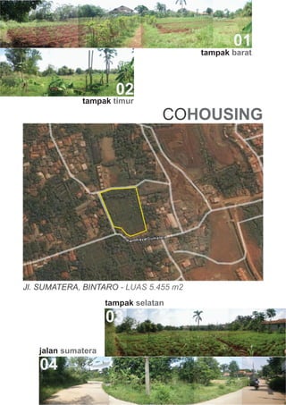
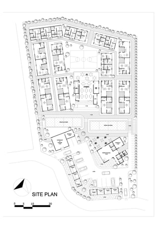
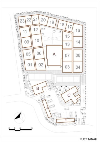
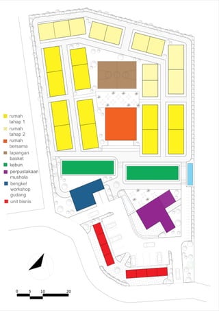
The document discusses cohousing, a type of collaborative housing where residents participate in the design and operation of their neighborhood. It provides a list of residents of the Klein Co-Housing community, their ages and occupations. It also includes a schedule of upcoming cohousing workshops and presentations from June to August 2009 to be held by the Rumah Bersama housing community.JAKARTA Multi Purpose Deep Tunnel
JAKARTA Multi Purpose Deep TunnelElisa Sutanudjaja
Ã˝
Proposal Deep Water Tunnel oleh Badan Regulasi Air Bersih DKI Jakarta. Proposal yang mengangankan adanya sistem sanitasi, pengendalian banjir dan jalan sekaligus.
Proposal yang tidak akan menyelesaikan masalah, dan hanya mengurangi dampak saja. 
Raperda rtrw terbaru
Raperda rtrw terbaruElisa Sutanudjaja
Ã˝
Peraturan Daerah ini mengatur tentang Rencana Tata Ruang Wilayah Provinsi Daerah Khusus Ibukota Jakarta 2030, yang meliputi pengelolaan ruang wilayah secara bijak dan berkelanjutan serta pengaturan penggunaan ruang untuk mencapai kualitas ruang yang baik hingga tahun 2030.101209 materi 1_prescon_kowar_jalan_layang_casablanca_antasari
101209 materi 1_prescon_kowar_jalan_layang_casablanca_antasariElisa Sutanudjaja
Ã˝
Dokumen tersebut membahas mengenai masalah kemacetan dan pencemaran udara di Jakarta yang disebabkan oleh pertumbuhan kendaraan bermotor yang pesat tanpa diimbangi dengan pengembangan infrastruktur transportasi yang memadai. Dokumen tersebut menyajikan statistik pertumbuhan kendaraan bermotor dan dampaknya terhadap kondisi lalu lintas serta kualitas udara di Jakarta. [/ringkasan]Introduction to theory and praxis of urban development concept part three
Introduction to theory and praxis of urban development concept part threeElisa Sutanudjaja
Ã˝
Dokumen tersebut membahas sejarah perkembangan peradaban urban manusia sejak 12.000 tahun lalu hingga saat ini, termasuk pengaruh ideologi, ilmu pengetahuan, dan teknologi terhadap perkembangan kota. Dokumen ini juga membahas dampak perkembangan peradaban urban terhadap masyarakat serta keraguan akan kemampuan manusia modern dalam memelihara kontinuitas keberadaan manusia di bumi.Introduction to theory and praxis of urban development (part one) power poin...
Introduction to theory and praxis of urban development (part one) power poin...Elisa Sutanudjaja
Ã˝
Proses transformasi urban mencakup perubahan struktural dan morfologi kota, baik fisik maupun non-fisik, yang direncanakan ataupun tidak.Introduction to theory and prxis of urban development concept part two power ...
Introduction to theory and prxis of urban development concept part two power ...Elisa Sutanudjaja
Ã˝
Around 90 million people or 45% of Indonesia's total population live in urban areas. The population of Jakarta, Indonesia's capital city, is around 20 million in the metropolitan area. Jakarta has experienced rapid urbanization and complex development over time as different ruling powers have shaped the city according to their agendas. As a result, Jakarta contains a mixture of urban characteristics from different historical periods, with elements from its indigenous pre-colonial foundations, the Dutch colonial era, Indonesia's independence movement, and modernization under President Sukarno in the mid-20th century. The document discusses the spatial transformations and cultural influences from each of these periods that collectively make Jakarta a heterogeneous city today.Green map icons_v3_definitions_stupa3
Green map icons_v3_definitions_stupa3Elisa Sutanudjaja
Ã˝
The document provides definitions for 170 icons in the Green Map System Icons Version 3. The icons are organized into 12 categories across 3 genres: Sustainable Living, Nature, and Culture & Society. The definitions describe what each icon represents, such as a farmers market, public transportation, green buildings, and more. Guidelines are provided for how mapmakers can utilize the icons on their Green Maps and related materials, with requirements to credit the Green Map System and include at least 50% of the global icons. Resources for the icons are available on the Green Map website.Green mapicons v3_chart_stupa3
Green mapicons v3_chart_stupa3Elisa Sutanudjaja
Ã˝
This document provides an overview of sustainability icons categorized into different themes such as green economy, nature, culture and society, and public works. It includes over 150 icons representing various sustainable sites, organizations, infrastructure, and activities. The icons are intended to be used on green maps to identify local ecological and social sustainability initiatives and resources.Map metro a3
Map metro a3Elisa Sutanudjaja
Ã˝
The document outlines a 25-year plan for Sydney, Australia that includes:
1) Accommodating over 1.1 million more residents and creating 640,000 new homes and 500,000 new jobs.
2) Developing five cities, three corridors, and a global city to better connect regions and strengthen economic ties.
3) Expanding the rail network and orbital motorway system to improve transportation between growth centers.2030 Vision Book 01
2030 Vision Book 01Elisa Sutanudjaja
Ã˝
The document presents a vision for a sustainable Sydney by 2030. It envisions a city that is green, globally significant, and well-connected. The green vision is for Sydney to be an environmental leader through reduced emissions, green infrastructure, and supporting new green industries. The global vision aims to maintain Sydney's status as Australia's most significant global city through world-class tourism, culture, and business. The connected vision outlines improving transportation networks to make Sydney easy to navigate as a pedestrian, cyclist, and public transit user both within the city and connecting to surrounding regions.Metro Strategy 0 Introduction
Metro Strategy 0 IntroductionElisa Sutanudjaja
Ã˝
The document presents a plan called the Metropolitan Strategy for Sydney's future growth over the next 25 years, which aims to strengthen Sydney's economy while balancing social and environmental impacts through managing anticipated population growth of 1.1 million people. The plan identifies priorities like enhancing liveability, economic competitiveness, fairness, environmental protection, and governance, and outlines strategies to achieve a vision of stronger regional cities and centres across Sydney that provide jobs, housing and services in growth areas.![Bahan Paparan Rtrw Dki 2010 2030 [Compatibility Mode]](https://cdn.slidesharecdn.com/ss_thumbnails/bahanpaparanrtrwdki2010-2030compatibilitymode-100104221956-phpapp01-thumbnail.jpg?width=560&fit=bounds)

Raperda RTRW Jakarta 2010-2030
Raperda RTRW Jakarta 2010-2030Elisa Sutanudjaja
Ã˝
Rancangan Peraturan Daerah ini membahas rencana tata ruang wilayah DKI Jakarta untuk periode 2010-2030 dengan mempertimbangkan perkembangan Jakarta sebagai kota metropolitan dan hubungannya dengan wilayah sekitar, serta menyesuaikan dengan peraturan baru tentang penataan ruang.PPT AMI Final
PPT AMI FinalElisa Sutanudjaja
Ã˝
The document describes the development of Jakarta's main road network and public transportation systems over the decades from the 1970s to 2000s. It notes the main roads and Kemayoran Airport in the 1970s, expanded main roads in the 1980s and 1990s, and then lists the various public transportation options that existed in Jakarta in the 2000s, including monorail, busway, MRT subway, and various stations and lines on the monorail and subway routes.
Hutan Bakau Kapuk
Hutan Bakau KapukElisa Sutanudjaja
Ã˝
1. Reklamasi lahan hutan bakau di Pantai Utara Jakarta untuk proyek perumahan mewah Pantai Indah Kapuk telah menghancurkan habitat alam dan meningkatkan risiko banjir.
2. Langkah reklamasi besar-besaran di lahan hutan bakau telah ditentang oleh para ahli lingkungan karena dampaknya yang merugikan.Wokshop Ami
Wokshop AmiElisa Sutanudjaja
Ã˝
Dokumen ini membahas tentang komuter di Jakarta dan ruang tinggal di kota. Jakarta mengalami pertumbuhan penduduk yang pesat sehingga jumlah komuter harian mencapai 6-7 juta orang. Namun ruang tinggal yang sebenarnya hanya di rumah, sementara sisa waktu dihabiskan di jalan karena kemacetan yang parah. Dokumen ini mengajak untuk memanfaatkan ruang kota sebagai ruang tinggal dan mengubah jalan tol menjadi tempat
More Related Content
More from Elisa Sutanudjaja (20)
JAKARTA Multi Purpose Deep Tunnel
JAKARTA Multi Purpose Deep TunnelElisa Sutanudjaja
Ã˝
Proposal Deep Water Tunnel oleh Badan Regulasi Air Bersih DKI Jakarta. Proposal yang mengangankan adanya sistem sanitasi, pengendalian banjir dan jalan sekaligus.
Proposal yang tidak akan menyelesaikan masalah, dan hanya mengurangi dampak saja. Raperda rtrw terbaru
Raperda rtrw terbaruElisa Sutanudjaja
Ã˝
Peraturan Daerah ini mengatur tentang Rencana Tata Ruang Wilayah Provinsi Daerah Khusus Ibukota Jakarta 2030, yang meliputi pengelolaan ruang wilayah secara bijak dan berkelanjutan serta pengaturan penggunaan ruang untuk mencapai kualitas ruang yang baik hingga tahun 2030.101209 materi 1_prescon_kowar_jalan_layang_casablanca_antasari
101209 materi 1_prescon_kowar_jalan_layang_casablanca_antasariElisa Sutanudjaja
Ã˝
Dokumen tersebut membahas mengenai masalah kemacetan dan pencemaran udara di Jakarta yang disebabkan oleh pertumbuhan kendaraan bermotor yang pesat tanpa diimbangi dengan pengembangan infrastruktur transportasi yang memadai. Dokumen tersebut menyajikan statistik pertumbuhan kendaraan bermotor dan dampaknya terhadap kondisi lalu lintas serta kualitas udara di Jakarta. [/ringkasan]Introduction to theory and praxis of urban development concept part three
Introduction to theory and praxis of urban development concept part threeElisa Sutanudjaja
Ã˝
Dokumen tersebut membahas sejarah perkembangan peradaban urban manusia sejak 12.000 tahun lalu hingga saat ini, termasuk pengaruh ideologi, ilmu pengetahuan, dan teknologi terhadap perkembangan kota. Dokumen ini juga membahas dampak perkembangan peradaban urban terhadap masyarakat serta keraguan akan kemampuan manusia modern dalam memelihara kontinuitas keberadaan manusia di bumi.Introduction to theory and praxis of urban development (part one) power poin...
Introduction to theory and praxis of urban development (part one) power poin...Elisa Sutanudjaja
Ã˝
Proses transformasi urban mencakup perubahan struktural dan morfologi kota, baik fisik maupun non-fisik, yang direncanakan ataupun tidak.Introduction to theory and prxis of urban development concept part two power ...
Introduction to theory and prxis of urban development concept part two power ...Elisa Sutanudjaja
Ã˝
Around 90 million people or 45% of Indonesia's total population live in urban areas. The population of Jakarta, Indonesia's capital city, is around 20 million in the metropolitan area. Jakarta has experienced rapid urbanization and complex development over time as different ruling powers have shaped the city according to their agendas. As a result, Jakarta contains a mixture of urban characteristics from different historical periods, with elements from its indigenous pre-colonial foundations, the Dutch colonial era, Indonesia's independence movement, and modernization under President Sukarno in the mid-20th century. The document discusses the spatial transformations and cultural influences from each of these periods that collectively make Jakarta a heterogeneous city today.Green map icons_v3_definitions_stupa3
Green map icons_v3_definitions_stupa3Elisa Sutanudjaja
Ã˝
The document provides definitions for 170 icons in the Green Map System Icons Version 3. The icons are organized into 12 categories across 3 genres: Sustainable Living, Nature, and Culture & Society. The definitions describe what each icon represents, such as a farmers market, public transportation, green buildings, and more. Guidelines are provided for how mapmakers can utilize the icons on their Green Maps and related materials, with requirements to credit the Green Map System and include at least 50% of the global icons. Resources for the icons are available on the Green Map website.Green mapicons v3_chart_stupa3
Green mapicons v3_chart_stupa3Elisa Sutanudjaja
Ã˝
This document provides an overview of sustainability icons categorized into different themes such as green economy, nature, culture and society, and public works. It includes over 150 icons representing various sustainable sites, organizations, infrastructure, and activities. The icons are intended to be used on green maps to identify local ecological and social sustainability initiatives and resources.Map metro a3
Map metro a3Elisa Sutanudjaja
Ã˝
The document outlines a 25-year plan for Sydney, Australia that includes:
1) Accommodating over 1.1 million more residents and creating 640,000 new homes and 500,000 new jobs.
2) Developing five cities, three corridors, and a global city to better connect regions and strengthen economic ties.
3) Expanding the rail network and orbital motorway system to improve transportation between growth centers.2030 Vision Book 01
2030 Vision Book 01Elisa Sutanudjaja
Ã˝
The document presents a vision for a sustainable Sydney by 2030. It envisions a city that is green, globally significant, and well-connected. The green vision is for Sydney to be an environmental leader through reduced emissions, green infrastructure, and supporting new green industries. The global vision aims to maintain Sydney's status as Australia's most significant global city through world-class tourism, culture, and business. The connected vision outlines improving transportation networks to make Sydney easy to navigate as a pedestrian, cyclist, and public transit user both within the city and connecting to surrounding regions.Metro Strategy 0 Introduction
Metro Strategy 0 IntroductionElisa Sutanudjaja
Ã˝
The document presents a plan called the Metropolitan Strategy for Sydney's future growth over the next 25 years, which aims to strengthen Sydney's economy while balancing social and environmental impacts through managing anticipated population growth of 1.1 million people. The plan identifies priorities like enhancing liveability, economic competitiveness, fairness, environmental protection, and governance, and outlines strategies to achieve a vision of stronger regional cities and centres across Sydney that provide jobs, housing and services in growth areas.Raperda RTRW Jakarta 2010-2030
Raperda RTRW Jakarta 2010-2030Elisa Sutanudjaja
Ã˝
Rancangan Peraturan Daerah ini membahas rencana tata ruang wilayah DKI Jakarta untuk periode 2010-2030 dengan mempertimbangkan perkembangan Jakarta sebagai kota metropolitan dan hubungannya dengan wilayah sekitar, serta menyesuaikan dengan peraturan baru tentang penataan ruang.PPT AMI Final
PPT AMI FinalElisa Sutanudjaja
Ã˝
The document describes the development of Jakarta's main road network and public transportation systems over the decades from the 1970s to 2000s. It notes the main roads and Kemayoran Airport in the 1970s, expanded main roads in the 1980s and 1990s, and then lists the various public transportation options that existed in Jakarta in the 2000s, including monorail, busway, MRT subway, and various stations and lines on the monorail and subway routes.Hutan Bakau Kapuk
Hutan Bakau KapukElisa Sutanudjaja
Ã˝
1. Reklamasi lahan hutan bakau di Pantai Utara Jakarta untuk proyek perumahan mewah Pantai Indah Kapuk telah menghancurkan habitat alam dan meningkatkan risiko banjir.
2. Langkah reklamasi besar-besaran di lahan hutan bakau telah ditentang oleh para ahli lingkungan karena dampaknya yang merugikan.Wokshop Ami
Wokshop AmiElisa Sutanudjaja
Ã˝
Dokumen ini membahas tentang komuter di Jakarta dan ruang tinggal di kota. Jakarta mengalami pertumbuhan penduduk yang pesat sehingga jumlah komuter harian mencapai 6-7 juta orang. Namun ruang tinggal yang sebenarnya hanya di rumah, sementara sisa waktu dihabiskan di jalan karena kemacetan yang parah. Dokumen ini mengajak untuk memanfaatkan ruang kota sebagai ruang tinggal dan mengubah jalan tol menjadi tempat