Saudi arabia
âĒ
0 likesâĒ414 views

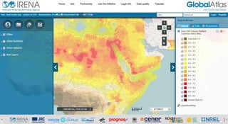
Saudi Arabia solar map shows GHI and DNI over Saudi Arabia with several areas of high potential. In this map, you would also find several other ancillary data layers such as, protected areas, hydrography grid, slope etc. This map was created by the German Aerospace Center (DLR) for educational purposes only. It shows an example of identification of solar opportunity areas based on exclusion criteria. The base solar dataset was developed by NREL for the SWERA programme (UNEP). The user can activate the various filters and view the remaining zones. Access the maps through: http://irena.masdar.ac.ae/?map=179