Globes and maps for class 6
- 1. Class 6
- 2. ’üĮ A globe is a small scale 3 dimensional model of the earth. ’üĮ It shows the exact shape of the earth. ’üĮ It also shows the shapes of the continents and the oceans.
- 3. ’üĮ It is bulky and cannot stored easily. ’üĮ Details regarding landforms, location of small town cannot be shown. ’üĮ It cannot provide detailed information about climate, vegetation, agriculture.
- 4. ’üĮ A diagrammatic representation of an area of land or sea showing physical features, cities, roads, etc.
- 6. Advantages (pros) ’āś It is easy to handle and carry. ’āś It can show continents, countries, cities and even a local area. Disadvantages (cons) ’āś It cannot show the curved surface of area. ’āś When it is drawn, the shapes and sizes of the continents and oceans get distorted.
- 7. ’üĮ He was a seventeenth century geographer, cartographer and mathematician.
- 8. ’üĮ A Dutch cartographer. ’üĮ He helped Mercator to made first attempt to publish a collection of maps in the form of a book.
- 10. ’üĮPolitical maps ’üĮPhysical maps ’üĮTopographical maps ’üĮClimatic maps ’üĮTourist maps ’üĮThepatic maps
- 11. ’üĮ Shows the boundaries of countries, states and districts.
- 12. ’üĮ Shows the landforms and water bodies on the earthŌĆÖs surface.
- 13. ’üĮ It shows great details of both natural and man- made features of a small area, with the help of conventional symbols.
- 14. ’üĮ It shows the different climate zones around the world. Climate is a particular combination of temperature and rainfall in any area over a long period of time.
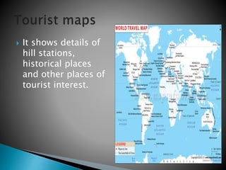
- 15. ’üĮ It shows details of hill stations, historical places and other places of tourist interest.
- 16. ’üĮ Shows distribution of forests, crops, minerals and industries.


