Systemwide2
0 likes113 views

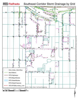
This document contains a table listing details of various storm drainage pipes located across the southeast corridor of an unspecified city. The table includes information such as pipe material, diameter, length, slope and location for over 30 separate storm drainage systems. A map is also referenced showing the locations of these storm drainage features in relation to key transportation, water and municipal boundaries. The document appears to be an inventory and analysis of existing storm drainage infrastructure for planning purposes.
1 of 1
Download to read offline
Recommended
Cuban Cigar Makers
Cuban Cigar MakersYuting Sun
?
The document summarizes census data from 1880 about the race of Cuban cigar makers in Manhattan, New York City. It shows that there were 66 Black Cuban cigar makers and 218 non-Black Cuban cigar makers. A map indicates the location of Manhattan and provides some historical context that Cuban cigar making was a prominent industry in New York City at that time.accident map improved
accident map improvedNathaniel Hougrand
?
This document contains a map of the Lower Connecticut River Valley region showing the locations of bicycle and pedestrian accidents from 2009 to 2013. The map includes symbols representing pedestrian accidents and bicycle accidents at their locations. It also shows the major roads and highways in the region, including interstate highways, US routes, and state routes.RIBEIR?O PIANC?- Mapa de representa??o das nascente e sedes das propriedades ...
RIBEIR?O PIANC?- Mapa de representa??o das nascente e sedes das propriedades ...Alexia Regine
?
This document contains a map and summary information about the Pianc©« River Basin located in Goi©ós, Brazil. The map shows the boundaries of the basin, surrounding municipalities, properties within the basin, and the locations of the river's headwaters. It was created by researchers from the ACQUAGEO project to illustrate geographical features of the basin including topography, hydrography, and administrative boundaries.Map of city managed natural areas
Map of city managed natural areassallybayliss
?
This map shows city-managed natural areas and parks on the Gold Coast in Queensland, Australia. It displays the boundaries of the local government areas (LGAs) of Gold Coast City, Logan City, Redland City, and Tweed Shire councils. Within the LGAs it shows areas managed by the cities including natural areas, parks, watercourses, and land managed by SEQ Water and the state including national parks. Major roads are also indicated for context. The map is intended to display the city-managed natural lands in the region.Mappatura delle asfaltature
Mappatura delle asfaltatureEstensecom
?
The document is a map of provincial roads in Ferrara, Italy. It shows the roads labeled with their route numbers and includes a color-coded index of the condition of the road surfaces. The index ranges from no degradation to critical degradation. This provides a summary of the conditions of the roads to help with monitoring and planning maintenance.Marzenia Www Alejaja Pl
Marzenia Www Alejaja Plgrabanna
?
The document appears to describe a tour of a model home, with the visitor expressing surprise, delight, and discomfort at what they encounter in each room before desperately trying to exit and return home, ultimately expressing shock and frustration at their inability to leave.Gimnasia cerebral
Gimnasia cerebralMonica Fronti
?
The document describes a group of girls building castles at the playground. They spent time constructing towers, turrets and bridges out of wood, rocks and plants. One girl's castle was destroyed, but they worked together to build another. The girls learned an important lesson about taking time to build things and helping each other.Artzigogoli appendigioielli
Artzigogoli appendigioielliartzigogoli
?
This document appears to be promoting a blog called "Artzigogoli.blogspot.com" as it is repeated 5 times without any other context or information provided. The blog seems to focus on arts and crafts projects based on the Italian word "Artzigogoli" which can be translated as "odds and ends" or "nicknacks".Shark
Sharkbquick
?
The document appears to be a script for a comedy video involving two people jumping into a pool with fake sharks. However, it is then revealed that real sharks were obtained for the video instead. The two people are attacked by the real sharks and call for help, but it turns out there were actually only two sharks. The rest of the script involves the characters discovering they have magical powers and transforming, with one character threatening to get the other at the end if the sharks didn't.ČĪ═ķąĪĄĄ░Ė
ČĪ═ķąĪĄĄ░Ėųą čļ╔ń
?
This document provides information on the chemical n-butane. It lists key details about n-butane including its chemical formula, CAS number, physical properties, exposure limits, flammability information, toxicological data, transportation classification and references. Specifically, it notes that n-butane is a colorless gas with a boiling point of -1 degree Celsius. It also lists the chemical's TWA, STEL and Ceiling exposure limits, flammability limits, autoignition temperature and density.Exploring the world
Exploring the worldguest25274f
?
The document describes a man's harrowing journey around the world. During his travels, he encounters many dangerous and bizarre situations in the jungle, including finding a mysterious walkway, being attacked by a bull, stung by a jellyfish, and having his canoe capsized by a creature. Throughout his ordeal, the man is constantly surprised and distressed by the events. By the end, the man is exhausted by his misadventures and relieved his journey has finally concluded.Auburn Gas Gathering System Map
Auburn Gas Gathering System MapMarcellus Drilling News
?
A map of the Auburn Gas Gathering System, located in northeastern Pennsylvania. The pipeline system is co-owned and operated by Williams, Epsilon Energy and Statoil. It is located in Susquehanna County, PA.Do you trust engineers
Do you trust engineersJatin Jindal
?
The document discusses a new engineering structure that appears to be a roller coaster based on its hanging 866 feet in the air, 70 degree tilt, and doing it at night too. It questions how much engineers can be trusted to build such an "out there" structure that hangs people high in the air and at steep angles for fun on a roller coaster. In the end, it expresses trust in the engineers to design and build such a daring ride.Do You Trust Engineers
Do You Trust Engineersnimiaazucena
?
The document discusses a new structure that was built by engineers that resembles a roller coaster but is meant for viewing. It hangs 866 feet high and tilts at a 70 degree angle. While it could be used for fun like a roller coaster, it is meant as an "out there" viewing platform or restaurant. The structure can also be experienced at night and reinforces trust in engineers to design and build such an impressive feat.Artzigogoli spaventapiccioni
Artzigogoli spaventapiccioniartzigogoli
?
This document appears to be a list of URLs for the same blog site artzigogoli.blogspot.com repeated multiple times. The blog likely focuses on creative activities and scarecrows based on its title "creAttivit©ż Spaventapiccioni". However, without visiting the listed URLs or having more context around the document, the key information that can be summarized is limited to the repeated listing of this single blog site URL.Choose Your Friends Wisely
Choose Your Friends WiselyGeorge Hutton
?
http://mindpersuasion.com/
On a deep level, your skills are thought of as companions. Choose wisely, and you'll not want for anything. http://mindpersuasion.com/charisma/Were you there
Were you thereLinnea Good
?
This African-American spiritual asks a series of questions about witnessing the crucifixion and burial of Jesus Christ. It expresses being moved to tremble at the thought of Jesus being crucified, nailed to the tree, the sun refusing to shine at his death, and being laid in the tomb. The spiritual is composed of repetitive lyrics that emphasize bearing witness to the suffering of Jesus.Aamyre Tarique - Design Portfolio
Aamyre Tarique - Design PortfolioAamyre Tarique
?
I have a keen interest in history, arts and technology. Furthermore, in my eleven years of work experience, I have developed outstanding interpersonal communication and time management skills.Arabic 301 Oral presentation
Arabic 301 Oral presentationCaron Creighton
?
A village elder shared a story with children about a traveler who became lost in the forest but was helped by animals. The animals worked together using their unique abilities to guide the man out of the forest safely. The elder's message was that cooperation and helping one another is important.???? ??????
???? ??????Sonu Khanna
?
The document appears to be in an unknown language and contains symbols and formatting that provide no discernible meaning in 3 sentences or less. The text strings are not in English and no context is provided to summarize the high-level ideas or essential information.Prepositions (Legal Writing)
Prepositions (Legal Writing)Mirea Mizushima
?
This document discusses the proper use of prepositions in the English language through examples of sentences containing ambiguous prepositions. It explores the different prepositions that can be used in various contexts and phrases, examining how subtle changes in prepositions can alter the meaning of sentences. Key prepositions discussed include in, at, of, for, to, with, by, from, on, about, against, among, over, of, into, onto and thereof/therefor/therefrom.CTM
CTMBloqInter
?
The document expresses extreme frustration and pain through repetitive exclamations of "CONCHETUMAAAAAARE!!" which can be translated to "motherfucker". Various emotions are conveyed such as "DOLOR" (pain), "ARGGHHH" (anguish), and stating that something has gone wrong by saying "KE ES ESTO" (what is this) and "ME CAGARON" (they screwed me). Overall the summary is expressing intense anger and distress through the repeated use of a Spanish swear word.Imagenes que te hace decir CONCHETUMAAAARE!!!
Imagenes que te hace decir CONCHETUMAAAARE!!!pacho54
?
The document expresses extreme frustration and pain through repetitive exclamations of "CONCHETUMAAAAAARE!!" which can be translated roughly as "motherfucker!". Various emotions are conveyed such as "DOLOR" (pain), "ARGGHHH" (anguish), and stating that something has gone wrong by saying "KE ES ESTO" (what is this) and "ME CAGARON" (they screwed me). Overall the summary is expressing intense anger and distress through colorful language.Fotos para decir conchetuma...
Fotos para decir conchetuma...maurycio
?
The document expresses extreme frustration and pain through repetitive exclamations of "CONCHETUMAAAAAARE!!" which can be translated to "motherfucker". Various emotions are conveyed such as "DOLOR" (pain), "ARGGHHH" (anguish), and stating that something has gone wrong by saying "KE ES ESTO" (what is this) and "ME CAGARON" (they screwed me). Overall the summary is a document expressing anger and distress through repetitive swearing in Spanish.Conchesumadre
Conchesumadrepolicecito
?
The document expresses extreme frustration and pain through repetitive exclamations of "CONCHETUMAAAAAARE!!" which can be translated roughly as "motherfucker". Various afflictions and annoyances are complained about, with no other context provided about the situation being referenced. The document provides little information due to its minimal and repetitious content.Lophii's Lantern - Storyboard Excerpt
Lophii's Lantern - Storyboard ExcerptAllie Vanaman
?
A young girl with a love for mechanics and robots travels to a strange city. A storyboard excerpt from a personal feature film idea.Miprimer slidehare
Miprimer slidehareAna Gonzalez Yepez
?
This document does not contain any meaningful information to summarize. It consists entirely of repeated letters and does not express a clear idea or topic that could be condensed into a 3 sentence summary.
PROGRAMA DE ESTUDIOS 2011frida-hdz
?
Este documento presenta el Plan de Estudios 2011 para la Educaci©«n B©ósica en M©”xico. Detalla los antecedentes de la Reforma Integral de la Educaci©«n B©ósica, incluyendo acuerdos previos para mejorar la calidad educativa. Describe los principios pedag©«gicos, competencias, perfil de egreso y mapa curricular que sustentan el plan. Finalmente, explica los campos de formaci©«n, est©óndares curriculares y aprendizajes esperados para cada nivel educativo.PSA- BIO100
PSA- BIO100rodriguez1990
?
Nine billion tons of litter is dumped into the oceans each year, with cigarette butts making up half of all littered items. Litter negatively impacts communities through lower property values and quality of life, as well as causing environmental contamination. To help address this problem, individuals should choose not to litter, not to smoke, and volunteer for community cleanups to prevent and remove litter.¦¬¦▀¦Ń¦õ¦Ō¦Õ¦▐¦ų¦▀¦õ¦Ē ¦▀¦č¦Ō¦Ó¦š¦▀¦Ó¦į¦Ó ¦Ó¦Ō¦▄¦ų¦Ń¦õ¦Ō¦č
¦¬¦▀¦Ń¦õ¦Ō¦Õ¦▐¦ų¦▀¦õ¦Ē ¦▀¦č¦Ō¦Ó¦š¦▀¦Ó¦į¦Ó ¦Ó¦Ō¦▄¦ų¦Ń¦õ¦Ō¦čdetsad55
?
¦┌¦▀¦Ń¦õ¦Ō¦Õ¦▐¦ų¦▀¦õ¦Ē ¦▀¦č¦Ō¦Ó¦š¦▀¦Ó¦į¦Ó ¦Ó¦Ō¦▄¦ų¦Ń¦õ¦Ō¦čMore Related Content
What's hot (19)
Shark
Sharkbquick
?
The document appears to be a script for a comedy video involving two people jumping into a pool with fake sharks. However, it is then revealed that real sharks were obtained for the video instead. The two people are attacked by the real sharks and call for help, but it turns out there were actually only two sharks. The rest of the script involves the characters discovering they have magical powers and transforming, with one character threatening to get the other at the end if the sharks didn't.ČĪ═ķąĪĄĄ░Ė
ČĪ═ķąĪĄĄ░Ėųą čļ╔ń
?
This document provides information on the chemical n-butane. It lists key details about n-butane including its chemical formula, CAS number, physical properties, exposure limits, flammability information, toxicological data, transportation classification and references. Specifically, it notes that n-butane is a colorless gas with a boiling point of -1 degree Celsius. It also lists the chemical's TWA, STEL and Ceiling exposure limits, flammability limits, autoignition temperature and density.Exploring the world
Exploring the worldguest25274f
?
The document describes a man's harrowing journey around the world. During his travels, he encounters many dangerous and bizarre situations in the jungle, including finding a mysterious walkway, being attacked by a bull, stung by a jellyfish, and having his canoe capsized by a creature. Throughout his ordeal, the man is constantly surprised and distressed by the events. By the end, the man is exhausted by his misadventures and relieved his journey has finally concluded.Auburn Gas Gathering System Map
Auburn Gas Gathering System MapMarcellus Drilling News
?
A map of the Auburn Gas Gathering System, located in northeastern Pennsylvania. The pipeline system is co-owned and operated by Williams, Epsilon Energy and Statoil. It is located in Susquehanna County, PA.Do you trust engineers
Do you trust engineersJatin Jindal
?
The document discusses a new engineering structure that appears to be a roller coaster based on its hanging 866 feet in the air, 70 degree tilt, and doing it at night too. It questions how much engineers can be trusted to build such an "out there" structure that hangs people high in the air and at steep angles for fun on a roller coaster. In the end, it expresses trust in the engineers to design and build such a daring ride.Do You Trust Engineers
Do You Trust Engineersnimiaazucena
?
The document discusses a new structure that was built by engineers that resembles a roller coaster but is meant for viewing. It hangs 866 feet high and tilts at a 70 degree angle. While it could be used for fun like a roller coaster, it is meant as an "out there" viewing platform or restaurant. The structure can also be experienced at night and reinforces trust in engineers to design and build such an impressive feat.Artzigogoli spaventapiccioni
Artzigogoli spaventapiccioniartzigogoli
?
This document appears to be a list of URLs for the same blog site artzigogoli.blogspot.com repeated multiple times. The blog likely focuses on creative activities and scarecrows based on its title "creAttivit©ż Spaventapiccioni". However, without visiting the listed URLs or having more context around the document, the key information that can be summarized is limited to the repeated listing of this single blog site URL.Choose Your Friends Wisely
Choose Your Friends WiselyGeorge Hutton
?
http://mindpersuasion.com/
On a deep level, your skills are thought of as companions. Choose wisely, and you'll not want for anything. http://mindpersuasion.com/charisma/Were you there
Were you thereLinnea Good
?
This African-American spiritual asks a series of questions about witnessing the crucifixion and burial of Jesus Christ. It expresses being moved to tremble at the thought of Jesus being crucified, nailed to the tree, the sun refusing to shine at his death, and being laid in the tomb. The spiritual is composed of repetitive lyrics that emphasize bearing witness to the suffering of Jesus.Aamyre Tarique - Design Portfolio
Aamyre Tarique - Design PortfolioAamyre Tarique
?
I have a keen interest in history, arts and technology. Furthermore, in my eleven years of work experience, I have developed outstanding interpersonal communication and time management skills.Arabic 301 Oral presentation
Arabic 301 Oral presentationCaron Creighton
?
A village elder shared a story with children about a traveler who became lost in the forest but was helped by animals. The animals worked together using their unique abilities to guide the man out of the forest safely. The elder's message was that cooperation and helping one another is important.???? ??????
???? ??????Sonu Khanna
?
The document appears to be in an unknown language and contains symbols and formatting that provide no discernible meaning in 3 sentences or less. The text strings are not in English and no context is provided to summarize the high-level ideas or essential information.Prepositions (Legal Writing)
Prepositions (Legal Writing)Mirea Mizushima
?
This document discusses the proper use of prepositions in the English language through examples of sentences containing ambiguous prepositions. It explores the different prepositions that can be used in various contexts and phrases, examining how subtle changes in prepositions can alter the meaning of sentences. Key prepositions discussed include in, at, of, for, to, with, by, from, on, about, against, among, over, of, into, onto and thereof/therefor/therefrom.CTM
CTMBloqInter
?
The document expresses extreme frustration and pain through repetitive exclamations of "CONCHETUMAAAAAARE!!" which can be translated to "motherfucker". Various emotions are conveyed such as "DOLOR" (pain), "ARGGHHH" (anguish), and stating that something has gone wrong by saying "KE ES ESTO" (what is this) and "ME CAGARON" (they screwed me). Overall the summary is expressing intense anger and distress through the repeated use of a Spanish swear word.Imagenes que te hace decir CONCHETUMAAAARE!!!
Imagenes que te hace decir CONCHETUMAAAARE!!!pacho54
?
The document expresses extreme frustration and pain through repetitive exclamations of "CONCHETUMAAAAAARE!!" which can be translated roughly as "motherfucker!". Various emotions are conveyed such as "DOLOR" (pain), "ARGGHHH" (anguish), and stating that something has gone wrong by saying "KE ES ESTO" (what is this) and "ME CAGARON" (they screwed me). Overall the summary is expressing intense anger and distress through colorful language.Fotos para decir conchetuma...
Fotos para decir conchetuma...maurycio
?
The document expresses extreme frustration and pain through repetitive exclamations of "CONCHETUMAAAAAARE!!" which can be translated to "motherfucker". Various emotions are conveyed such as "DOLOR" (pain), "ARGGHHH" (anguish), and stating that something has gone wrong by saying "KE ES ESTO" (what is this) and "ME CAGARON" (they screwed me). Overall the summary is a document expressing anger and distress through repetitive swearing in Spanish.Conchesumadre
Conchesumadrepolicecito
?
The document expresses extreme frustration and pain through repetitive exclamations of "CONCHETUMAAAAAARE!!" which can be translated roughly as "motherfucker". Various afflictions and annoyances are complained about, with no other context provided about the situation being referenced. The document provides little information due to its minimal and repetitious content.Lophii's Lantern - Storyboard Excerpt
Lophii's Lantern - Storyboard ExcerptAllie Vanaman
?
A young girl with a love for mechanics and robots travels to a strange city. A storyboard excerpt from a personal feature film idea.Miprimer slidehare
Miprimer slidehareAna Gonzalez Yepez
?
This document does not contain any meaningful information to summarize. It consists entirely of repeated letters and does not express a clear idea or topic that could be condensed into a 3 sentence summary.Viewers also liked (11)
PROGRAMA DE ESTUDIOS 2011frida-hdz
?
Este documento presenta el Plan de Estudios 2011 para la Educaci©«n B©ósica en M©”xico. Detalla los antecedentes de la Reforma Integral de la Educaci©«n B©ósica, incluyendo acuerdos previos para mejorar la calidad educativa. Describe los principios pedag©«gicos, competencias, perfil de egreso y mapa curricular que sustentan el plan. Finalmente, explica los campos de formaci©«n, est©óndares curriculares y aprendizajes esperados para cada nivel educativo.PSA- BIO100
PSA- BIO100rodriguez1990
?
Nine billion tons of litter is dumped into the oceans each year, with cigarette butts making up half of all littered items. Litter negatively impacts communities through lower property values and quality of life, as well as causing environmental contamination. To help address this problem, individuals should choose not to litter, not to smoke, and volunteer for community cleanups to prevent and remove litter.¦¬¦▀¦Ń¦õ¦Ō¦Õ¦▐¦ų¦▀¦õ¦Ē ¦▀¦č¦Ō¦Ó¦š¦▀¦Ó¦į¦Ó ¦Ó¦Ō¦▄¦ų¦Ń¦õ¦Ō¦č
¦¬¦▀¦Ń¦õ¦Ō¦Õ¦▐¦ų¦▀¦õ¦Ē ¦▀¦č¦Ō¦Ó¦š¦▀¦Ó¦į¦Ó ¦Ó¦Ō¦▄¦ų¦Ń¦õ¦Ō¦čdetsad55
?
¦┌¦▀¦Ń¦õ¦Ō¦Õ¦▐¦ų¦▀¦õ¦Ē ¦▀¦č¦Ō¦Ó¦š¦▀¦Ó¦į¦Ó ¦Ó¦Ō¦▄¦ų¦Ń¦õ¦Ō¦čBuilding Products and Materials Industry Insights - Q1 2016
Building Products and Materials Industry Insights - Q1 2016Duff & Phelps
?
2015 was the most active year for the housing market since the economic downturn. Housing starts increased 10.8% and finished the year with nine consecutive months above the one million mark (annual rate). New and existing home sales reached their highest levels since 2007 and 2006, respectively, while home prices continued to climb. The favorable trends drove increased M&A activity with 161 transactions completed in 2015.
Capital Markets Insights: Credit Availability for the Middle Market Remains R...
Capital Markets Insights: Credit Availability for the Middle Market Remains R...Duff & Phelps
?
Recent trimming in first lien debt appetite resulted in a higher proportion of second lien and junior debt in capital structures. The fuller covenant packages typical of the private market, combined with unabated growth in private investor capital formation, have served to differentiate middle market conditions from those of the broader liquid markets. While the weighted average cost of debt for middle market issuers has increased modestly, credit availability Ī¬ both in terms of leverage multiples and cost Ī¬ is robust.Plant Pathogen Booklet
Plant Pathogen BookletAli Mahmoudpour, Ph.D.
?
This document provides information about a plant pathogen detection kit from Norgen Biotek Corp. that allows for the isolation and detection of fungal pathogens from plant samples using PCR. The kit contains components for isolating DNA from plant tissues using spin column chromatography. It also contains master mixes for amplifying fungal DNA, as well as controls. The kit is a ready-to-use system for detecting pathogens like Aspergillus niger, Botrytis cinerea, Cladosporium cladosporioides, Penicillium sp., and others from plant samples in under 3 hours.Buckling of a beam with two ended s
Buckling of a beam with two ended smaryam ghasemzadeh
?
this file analising the buckling of a simply supported beam in two cases. first case eigen value method for analisig a ideal beam under compressive load and in case two the beam has imperfection .
the imperfection of beam is in the sacles of the mood that the eigen values method gives.
2.3 - Inicio y Definicion del ProyectoVladimir Columna, MDGDP
?
El documento presenta una introducci©«n al curso de gerencia de proyectos. Explica los conceptos clave de inicio y definici©«n del proyecto, identificaci©«n de partes interesadas, y creaci©«n de la carta del proyecto. El objetivo es familiarizar a los estudiantes con los principios fundamentales de la gerencia de proyectos.2016 The Agile Museum: Innovative Leadership for the 21st Century
2016 The Agile Museum: Innovative Leadership for the 21st CenturyThe Metropolitan Museum of Art
?
║▌║▌▀Ż deck from presentation at joint AMM/MAM Conference, July 2016, Minneapolis.
Session Abstract:
Organizations across sectors are succeeding by adopting innovative leadership practices, described variously as Lean, Agile, Radical, and Open. Using specific examples, this session will present the thinking and practice of these new approaches as applied in the cultural heritage sector via open discussion and active debate.
#AMM2016
Edfisica generoLorena Flores
?
Este documento presenta una gu©¬a did©óctica sobre la educaci©«n f©¬sica desde un enfoque de g©”nero. Explica que la educaci©«n f©¬sica es un espacio importante para trabajar temas de g©”nero y promover la igualdad. Define los conceptos de sexo, g©”nero e identidad de g©”nero, y c©«mo a trav©”s de la socializaci©«n se aprenden roles de g©”nero que pueden limitar a ni?os y ni?as. El objetivo es sensibilizar a docentes para que cuestionen estereotipos de g©”nero y promuevanSimilar to Systemwide2 (20)
sepaku1.pdf
sepaku1.pdfArief Rahman
?
The document is a map showing geographic coordinates and distances. It depicts an area bounded by the coordinates 468600, 468800, 469000, 469200, 469400 easting and 9891800, 9892000, 9892200 northing. A scale bar indicates that 0.025 miles is equal to 0.05 units on the map.Mariah_WindFarm_Detail_091115
Mariah_WindFarm_Detail_091115Robert Fritz
?
This document provides an overview of the Mariah South wind farm project located in Parmer and Castro Counties, Texas. It details that there are 78 total wind turbines planned for the project, ranging in model from GE 2.3MW turbines. The turbines will be organized into 8 collector circuits (A-H) that will feed into the main substation. A transmission line will connect the substation to the regional electric grid. The map shown outlines the turbine locations, collector circuit configurations, substation site, and surrounding area.27.pdf
27.pdfZuberJinodi
?
This document provides a map of the administrative divisions of Maharashtra state in India for the year 2011. It shows the state divided into 36 districts, which are further divided into talukas or tahsils. Notes are provided to indicate where district and tahsil headquarters differ from the place names and to clarify administrative arrangements in certain areas. Key at the bottom explains symbols on the map for districts, tahsils, railways, and state/territory boundaries.PreviousWorkArchaeologicalSites
PreviousWorkArchaeologicalSitesMohamad Chibli
?
This document discusses criteria for mapping lands suitable for residential development near archaeological sites along Alligator Alley in Florida. It identifies existing residential areas and calculates the average distance and standard deviation from archaeological sites to determine how close new residential development should be located for economic viability and cultural preservation. The goal is to identify economically suitable lands for housing while also considering people's preference to live near historic and cultural amenities like archaeological sites.
dengue-1.pdf
dengue-1.pdfMonishabasavaraj
?
The document is a map showing reported cases of Dengue fever in the Mysuru district of Karnataka, India. The map divides the district into color-coded zones based on the number of reported Dengue cases, with red indicating the highest levels of cases over 50,000. It also shows the locations of major towns and cities within the district boundaries.Carmarthenshire Photographic Archives
Carmarthenshire Photographic ArchivesMontessori Centre Wales
?
The launch of a new photographic archive in St. Clears, Carmarthenshire aims to digitize tens of thousands of images documenting daily life in the area from the early 1900s to the late 1970s. Volunteers are cataloging photos from the archives of five local photographers. Lists of names and event details will be published online and in local areas to reconnect people with lost photos of family, friends and community events. The collection will showcase the region's history and be preserved for future generations.Oryoki by Les Kaye
Oryoki by Les KayeEfra©¬n Su©órez-Arce, M.Ed
?
The document describes the oryoki, eating bowls used by Zen students. Using oryoki during meals provides an opportunity to deepen practice by paying careful attention to how one takes their meals. The bowls have been used in Chinese and Japanese monasteries for over 1000 years and are part of the Buddhist tradition of giving and non-attachment. The oryoki and the relationship between laypeople offering food and monks receiving it reflect important Buddhist concepts.Gaza 2014
Gaza 2014Melanie De Campos
?
This document summarizes the findings of an independent medical fact-finding mission to Gaza in 2014 following the armed conflict. The mission conducted interviews with injured patients in hospitals, performed forensic pathology examinations, and visited the town of Khuza'a. The mission found multiple types of injuries resulting in death, including those from shelling and airstrikes. Hospitals were severely overloaded with many casualties from incidents where no warnings were given. Medical personnel and facilities also came under attack. The long-term impact included widespread destruction of homes and trauma. The mission calls for accountability and improved health and social conditions.Figure 4-5. Zoning District
Figure 4-5. Zoning DistrictHeritage Wind
?
This document is a figure from a report on the Heritage Wind Project located in the Town of Barre, Orleans County, New York. It shows a map of the zoning districts in the town and surrounding 5-mile study area. There are several types of zoning districts identified, including agricultural, business, commercial, industrial, and residential districts. It also indicates where various project components like wind turbines, access roads, and substations would be located within the zoning map. The purpose is to analyze how the proposed wind project fits within the existing land use and zoning plans.Carretera de Apurimac 2
Carretera de Apurimac 2Estudio Ingenier©¬a Civil
?
The document is composed of symbols including !, $, and . in no discernible pattern, along with place names written in an unknown language. It does not contain any coherent sentences, paragraphs, or other standard elements of a document. The content and intent are unable to be determined from the symbols and placenames provided.Map of PGEC Territory
Map of PGEC TerritoryDwain Miller Jr., GISP
?
The document contains a series of random special characters and punctuation marks with no discernible meaning or pattern. There are no words, sentences, or identifiable concepts that could be summarized in 3 sentences or less. The document appears to be nonsense text without any essential information that could be extracted.▒¹Ž®ąĪĄĄ░Ė
▒¹Ž®ąĪĄĄ░Ėųą čļ╔ń
?
This document provides safety and handling information for propylene (propene, methylethylene). It lists identifying information including the CAS number and chemical formula. It outlines physical properties such as boiling point and vapor pressure. Exposure limits from sources like NIOSH and ACGI are cited. Health hazard data like lethal dose values are presented. Transportation classification numbers from agencies like DOT and IATA are provided. References conclude the document.Recomanacions nadal 2010
Recomanacions nadal 2010Albaricpena
?
The document discusses several people and places. It mentions the names of people like Tomoaki Ishii and locations such as Fukuoka. It provides brief descriptions of some individuals, including what they do for a living. The writing moves quickly between many different subjects in a non-linear fashion.More Time Now
More Time NowKhalil Aleker
?
This document discusses ways to free up more time by reducing wasted time. It argues that traditional time management techniques do not work because time cannot be managed, but one's mindset can be changed. It recommends focusing less on productivity and more on reducing unnecessary activities in order to focus on goals that are truly important. Specific behaviors to change include wasting time by avoiding meaningful tasks and engaging in escapist activities instead of true recreation. The goal is to make small, continuous improvements in reducing wasted time rather than expecting overnight changes.Bori Map (Routing) Rev 02
Bori Map (Routing) Rev 02Shola O. Aribido
?
This document discusses the optimization of solid waste collection and transportation in Bori, Khana Local Government Area, Rivers State, Nigeria. It presents a map showing the locations of existing waste collection bins and proposed new bin locations, along with the optimized routes for waste collection vehicles labeled as Routes A and B. The map also features the road network classification and locations of transfer stations and other facilities.Comparing the Severity of International Crime
Comparing the Severity of International CrimeAlixandra Greenman
?
This thesis examines whether there is a perceived hierarchy of severity among the charges of genocide, crimes against humanity, and war crimes under international law. The author conducts a mixed-methods analysis, first interpreting the definitions of these crimes in international treaties and statutes. Next, the author performs a content analysis of 122 cases and 186 defendants from the ICTY, ICTR, and SCSL to determine if one crime category receives longer sentences on average. The findings have implications for establishing consistency in sentencing across international tribunals and domestic courts applying international criminal law.NCC Constitution.
NCC Constitution.Nalinie Singh
?
This document outlines the constitution for the New College Council student government at York University. It establishes the council's name, mission, and defines key terms. The constitution details the council's membership, executive roles and responsibilities, meetings, elections, and amendments process. The goal is to govern the council in a democratic and responsible manner to represent students and enrich their educational experience.Andr©” Rieu: an Educational Appreciation
Andr©” Rieu: an Educational AppreciationWorld Appreciative Inquiry Conference 2012
?
1) Thirty-two educators from a South African secondary school participated in an appreciative workshop viewing a concert of Andre Rieu and his orchestra.
2) Through reflection questions, appreciative interviews, and discussion of themes, the educators sought to identify strengths from the performance that could improve their own teaching practices.
3) Key positive themes that emerged included passion and enthusiasm, teamwork, inclusivity, preparation and personal development, compassion, and appreciation.Mapa Ruta
Mapa RutaEder Gamarra Ccanri
?
This document provides a map and route description from Abancay to Cruzpata and Llicchivilca in Peru. The route from Abancay to Cruzpata involves traveling for 4 hours on an affirmed dirt road and then 2.5 hours on a trail. The route from Abancay to Llicchivilca takes approximately 4 hours entirely on an affirmed dirt road. Key locations along the routes are marked on the map.Systemwide2
- 1. !. !.!. !. !.!. !. !. !.!. !. !. !.!. !. !. !. !.!. !.!.!. !.!.!. !. !. !.!. !. !. !.!. !. !. !. !. !. !. !. !. !. !.!. !.!.!. !.!. !. !. !. !.!. !.!.!. !. !. !. !. !.!. !. !. !. !. !. !. !.!. !. !.!. !. !. !. !.!. !. !. !. !. !. !. !( !( !( !( !( !( !( !( !( !( !( !( !( !( !( !( !( !( !( !( !(!( !( !( !( !( !(!( !(!( !(!( !( !( !( !( !( !( !( !(!(!( !( !( !( !( !( !( !( E4 D4 E5 D5D3 EVANS UNIVERSITY BUCHTEL TURN LANE TURN LANE BUCHTEL 503'-24"-CMP 656'-33"-RCP-0.4% 449'-18"-RCP 565.'-24"-RCP-.7% 662.8'-21"-RCP-0.92% 617.71'-54"-RCP-0.38% 574.56' - 72" - RCP - 0.66% 140.43' 350' - 6" - CP - 0.7% 415.61' - 42" - RCP - 0.4% 438.58' - 21" - RCP - 0.85% 355.'-24"-RCP-.75% 349' - 24" - RCP - 0.4% 336.' - 30" - RCP - .53% 330' - 12" - VCP - 1.52% 320'-15"-PVC-1.09% 325.2'-24"-RCP-0.5% 301.'-36"-RCP-.13% 336.4' - 24" - RCP - 1.85% 304.'-24"-RCP-1.33%353.'-24"-RCP-2.% 254' - 24" - RCP - 0.4% 265'-12"-PVC-1% 273.56'-18"-PVC-1.39% 225'-12"-VCP-0.4% Grid_Index_StormSys StormMains RTD.Highways RTD.MajorStreets RTD.WaterBodies RTD.WaterFeatures RTD.RTDBoundary_Line 0 0.06 0.12 0.18 0.240.03 Miles ? Southeast Corridor Storm Drainage by Grid DocumentPath:N:PlanningAndDevelopmentEngineeringSystemwideGISArcMap10_Spatial_SystemwideSystemwide2.mxd Author: Clark J. Eckel - FasTracks Engineering