Por que no los dos
0 likes38 views

The document discusses the pros and cons of print maps versus digital maps. It notes that print maps can be accessed offline, help with cognitive comprehension, and provide a better big picture view, but are static and difficult to update. Digital maps allow for easy updating, dynamic filtering and scaling of data, translation to different languages, and interactive information, but require an online connection. The document concludes by suggesting using both print and digital maps together for their complementary benefits.
1 of 32
Download to read offline


Ad
Recommended
A3 Portsmouth Takeover 30:09:14
A3 Portsmouth Takeover 30:09:14Tom J Stirling
╠²
The document appears to be a flyer advertising a music festival called "Oxjam" taking place on October 18th, 2014 at the Southsea Social Club in Portsmouth. It lists over 20 musical artists and bands scheduled to perform, including The Fat Blacks, Attenborough, Sombulance, Waifs&Strays, Bluebird, Ollie Goodwin, Ryan James, Villiers, Megan Linford, Kodiak Jack, The Sixes & Sevens, El Capitan, TheArrivals, Barn Society, and WeCaptureKings and his imaginary friends. Advance tickets cost ┬Ż8 with tickets at the door costing ┬Ż10.C Y P Volunteers Rock Flyer F I N A L
C Y P Volunteers Rock Flyer F I N A Ljess5877
╠²
Volunteers Rock is a concert on November 3rd at Hard Rock Live in Biloxi that will give complimentary tickets to 500 volunteers from organizations along the Mississippi Gulf Coast in recognition of their service. Additional tickets sold will support the philanthropic projects of Coast Young Professionals. The concert featuring will provide entertainment starting at 8pm, with doors opening at 7pm. Tickets can be purchased starting at $15 from Ticketmaster or at the venue box office.2016 Korus passport
2016 Korus passportLuna Boleum Lee
╠²
This document provides information about the 14th Annual KORUS Festival that will take place on October 1-2, 2016 at the Tysons Corner Center in Northern Virginia. It will feature Korean music, dance, and food performances and activities to celebrate Korean culture. Over 30,000 people are expected to attend along with participation from over 50 vendors and community groups. The festival is organized by the Korean American Association of the Washington Metropolitan Area to showcase Korean heritage.Dice run flyer 30 sep 2012
Dice run flyer 30 sep 2012VFW Post 684
╠²
Veterans of Foreign Wars Post 684 is hosting a dice run on October 7th to raise funds for veterans programs and the VFW National Home for Children. Riders pay $20 per bike and $5 for a second rider to participate in the dice run. Riders will leave the VFW post between 11:30 am and 12:30 pm and return by 4 pm, making stops at four sponsor locations. Prizes will be awarded for 1st, 2nd, and worst scores. Food and drinks will be provided for participants.KTTC Page
KTTC PageGrant Gaar
╠²
Nearly 600 guests attended the 2013 Saks Fifth Avenue Key to the Cure black-tie gala held at the Fashion Mall at Keystone on October 11th. The event included cocktails, a silent auction, fashion show, dinner and dancing provided by DJ Gabby Love and The Flying Toasters band. More than $480,000 was raised to benefit female cancer patients at St. Vincent Cancer Care.30 years of women in District 7950
30 years of women in District 7950ChuckSauer1
╠²
This document celebrates 30 years of women in Rotary and lists the names of over 100 women who were among the earliest inducted into Rotary clubs in Massachusetts and Rhode Island between 1986-2016. It recognizes some of these women as the first female district governors and notes clubs chartered in 1989 that inducted multiple women on their first day allowing women to join.Sports Presentation
Sports PresentationTanner Huffman
╠²
This document discusses Ouachita Athletics at the university. It provides a brief history of sports programs starting in 1907, including football, basketball, baseball, women's basketball, track, and tennis. It notes Ouachita Athletics competes in Division II. The document outlines problems with low media coverage and fan base for Ouachita sports. It highlights some benefits of the athletics program to campus life, including events like Homecoming week and intramurals, as well as contributions to diversity and community fundraising.15 Westwoods Lane Charles Town WV 25414
15 Westwoods Lane Charles Town WV 25414Heather Harley
╠²
The document repeatedly lists the address 15 Westwoods Lane, Charles Town, WV 25414. It provides a contact for more information about the property, which is Kevin Coomler at ERA Liberty Realty, with a phone number of (304) 728-2000. The document primarily focuses on this address and the contact details for inquiries.Weld symbolsproof
Weld symbolsproofchander_sek
╠²
This document lists contact information for Mississippi Welders Supply Co., Inc. locations in Decorah, IA, Red Wing, MN, Rochester, MN, Winona, MN, Altoona, WI, Hudson, WI, La Crosse, WI, and Marshfield, WI, including addresses, phone numbers, and fax numbers. It also mentions that Mississippi Welders Supply Co., Inc. specializes in American Welding Society welding symbols.Facts&figures
Facts&figuresmvmfmarketing
╠²
Over 8 out of 10 victims of crime want more constructive activities for youth to prevent criminal engagement. On average 498 people sleep rough each night in the UK, with 248 in London. As of August 2011, there were 86,821 prisoners in the UK, most of whom were men. Various initiatives funded by donations engage at-risk youth and former prisoners through activities like life skills training, anger management, rehabilitation programs, and sports to reduce reoffending and homelessness. Donations were raised through events like balls, walks, concerts, and sporting activities.Daily Presentation [7 of 9]
Daily Presentation [7 of 9]S.C. Press Association
╠²
This document appears to be a list of award winners for various photo categories from newspapers of different circulation sizes. It provides the names of photographers and newspapers that won first, second, third place or honorable mentions for categories including general news photo, feature photo, sports action photo, sports feature photo, and personality/portrait photo. Awards are broken down by newspaper's daily circulation of under 20,000, 20,000-50,000, and over 50,000.Greater Pike Community Foundation Grants
Greater Pike Community Foundation GrantsHeron's Eye Communications
╠²
The Greater Pike Community Foundation has awarded over $75,000 in grants within two and a half years to support various local programs and services. Grant recipients include organizations such as the Black Bear Film Festival, the Center for Developmental Disabilities, and the Milford Community House. The foundation aims to enhance community resources and foster development in the region.'Brass Bands - An Undervalued Social Community Art'.
'Brass Bands - An Undervalued Social Community Art'. Andy Goodwin
╠²
Brass bands were a popular social activity for workers in the UK in the early 20th century, with an estimated 20,000 brass bands in existence. They provided musical entertainment at community events and helped bring communities together. However, brass bands declined dramatically due to a lack of funding and support, especially following the closure of mines and pits in the 1980s. Despite their cultural significance, brass bands receive significantly less funding than opera - for every ┬Ż1 given to brass bands, opera receives over ┬Ż1,000. Brass bands are still important today in rural communities and for developing skills in children through junior brass bands.FRSA Flash 16 August 2012
FRSA Flash 16 August 2012Redleg36
╠²
This document is a newsletter from the 3-6 Field Artillery Regiment at Fort Drum announcing upcoming community events from August 16 to September 15, including concerts by the 10th Mountain Division Band, workshops on employment, car buying and anger management, a Division picnic, and the New York State Fair. It also lists dates for Strong Bonds relationship programs and notifications about road closures and parking lot repaving at the Veteran's Clinic.tempest poster nov 7
tempest poster nov 7Mathew Houston
╠²
Middlesex Community College's Theater Department will present a production of William Shakespeare's play on December 4th and 5th at 7pm and December 6th and 7th at 2pm and 7pm in the Burgoyne Theater located at 40 page street in Lowell, Massachusetts. Tickets are $10 for MCC students and faculty and $15 for general admission, and can be purchased by calling 978-458-5429.Population Change: St. Louis County, MO
Population Change: St. Louis County, MONancy Cole
╠²
The document discusses population changes in St. Louis County, Missouri, highlighting numerical data from 1950 to 2010 for both the city and county. It notes specific municipalities that have experienced population loss and declines in median household income between 2000 and 2010. Additionally, it addresses the methodology and limitations involved in the population data analysis, including issues with municipal boundary geometry.Casino night ticket
Casino night ticketpdennis65
╠²
A casino night fundraiser will be held on September 28th, 2013 at Maylands Golf Club in Romford to benefit Macmillan Cancer Support. Attendees will receive a welcome drink, buffet, and 5 free casino chips for playing games starting at 8pm after a 7:30pm arrival. The event encourages black tie or James Bond costumes and tickets cost ┬Ż20 each.Lunch with a punch 2
Lunch with a punch 2Gradwoh2
╠²
The document provides information about events and activities in Old Town Lansing, Michigan. It discusses the history of Old Town Lansing and lists upcoming community events throughout the summer, including the Scrapfest collection day and auction in June, the Festival of the Moon and Sun in late June, and the Turner Street Outdoor Theater series in July. It encourages residents to get involved by volunteering, becoming members, or sponsoring events and thanks the community for coming together to support Old Town.School-Fort Bend ISD- Sugar Land, Richmond & surrounding cities, TX.
School-Fort Bend ISD- Sugar Land, Richmond & surrounding cities, TX. Champions Real Estate Group
╠²
This document lists contact information for all elementary, middle, high, and specialized schools in the Fort Bend Independent School District, including school addresses, telephone numbers, and web links. It provides a directory of over 70 schools in the district with their location and phone number. The source is the Fort Bend ISD website where readers can independently verify and get updated information.LUNCH WITH A PUNCH 2012
LUNCH WITH A PUNCH 2012Gradwoh2
╠²
The document provides information about events and activities in Old Town Lansing, Michigan. It discusses the history of Old Town Lansing and lists upcoming community events throughout the summer, including the Scrapfest Collection Day in June, the Festival of the Moon and Sun in June, and the Turner Street Outdoor Theater in July. It encourages readers to get involved by volunteering, becoming a member of the Old Town Community Association, or sponsoring events.Turtle Lake Inter-County Fair 2014 Sponsored by the Turtle Lake Lions Club
Turtle Lake Inter-County Fair 2014 Sponsored by the Turtle Lake Lions ClubLocust and Honey Productions
╠²
The document provides a schedule of events for the Turtle Lake Lions Club festival held from July 11-13, 2014. Events included a dairy cattle and sheep show, pedal tractor pull, cribbage and queen pageant on Friday. Saturday featured a pancake breakfast, fun run, truck and tractor pulls, queen coronation and live music. Sunday included a community church service, kids parade, chicken dinner, parade down Main Street, old fashioned tractor pull and kids races. Entertainment was provided each evening.KFP_Jully2016_MonthlyAccomp_v4
KFP_Jully2016_MonthlyAccomp_v4Rivka Goldstein
╠²
This document summarizes the accomplishments of a kosher food pantry for the month of July 2016. It distributed a total of 4,282 bags and served people across multiple neighborhoods in Cleveland and nearby cities. The pantry held regular distributions in local housing buildings and neighborhoods each week, in addition to its open pantry and outdoor produce distributions where it served over 200 people total.GRTHM Launch 2013
GRTHM Launch 2013Phil Regan
╠²
The V&A Museum in London will host an event on June 1st from 1-4:30pm to launch Gypsy Roma and Traveller History Month 2013. The event, funded by NIACE, will include an exhibition of art, artifacts and mini caravans, performances of poetry, song and dance, the launch of a new book, a film screening, and drinks and refreshments. Admission is ┬Ż3 per person.Exploring the Diverse Types of Textual Aids
Exploring the Diverse Types of Textual Aidsjenicahmendoza1
╠²
Exploring the Diverse Types of Textual AidsQuectel M10 AT commands Arduino Microcontroller
Quectel M10 AT commands Arduino MicrocontrollerAdamSunusiHaruna1
╠²
Quectel M10 AT commands Arduino Microcontroller More Related Content
What's hot (15)
Weld symbolsproof
Weld symbolsproofchander_sek
╠²
This document lists contact information for Mississippi Welders Supply Co., Inc. locations in Decorah, IA, Red Wing, MN, Rochester, MN, Winona, MN, Altoona, WI, Hudson, WI, La Crosse, WI, and Marshfield, WI, including addresses, phone numbers, and fax numbers. It also mentions that Mississippi Welders Supply Co., Inc. specializes in American Welding Society welding symbols.Facts&figures
Facts&figuresmvmfmarketing
╠²
Over 8 out of 10 victims of crime want more constructive activities for youth to prevent criminal engagement. On average 498 people sleep rough each night in the UK, with 248 in London. As of August 2011, there were 86,821 prisoners in the UK, most of whom were men. Various initiatives funded by donations engage at-risk youth and former prisoners through activities like life skills training, anger management, rehabilitation programs, and sports to reduce reoffending and homelessness. Donations were raised through events like balls, walks, concerts, and sporting activities.Daily Presentation [7 of 9]
Daily Presentation [7 of 9]S.C. Press Association
╠²
This document appears to be a list of award winners for various photo categories from newspapers of different circulation sizes. It provides the names of photographers and newspapers that won first, second, third place or honorable mentions for categories including general news photo, feature photo, sports action photo, sports feature photo, and personality/portrait photo. Awards are broken down by newspaper's daily circulation of under 20,000, 20,000-50,000, and over 50,000.Greater Pike Community Foundation Grants
Greater Pike Community Foundation GrantsHeron's Eye Communications
╠²
The Greater Pike Community Foundation has awarded over $75,000 in grants within two and a half years to support various local programs and services. Grant recipients include organizations such as the Black Bear Film Festival, the Center for Developmental Disabilities, and the Milford Community House. The foundation aims to enhance community resources and foster development in the region.'Brass Bands - An Undervalued Social Community Art'.
'Brass Bands - An Undervalued Social Community Art'. Andy Goodwin
╠²
Brass bands were a popular social activity for workers in the UK in the early 20th century, with an estimated 20,000 brass bands in existence. They provided musical entertainment at community events and helped bring communities together. However, brass bands declined dramatically due to a lack of funding and support, especially following the closure of mines and pits in the 1980s. Despite their cultural significance, brass bands receive significantly less funding than opera - for every ┬Ż1 given to brass bands, opera receives over ┬Ż1,000. Brass bands are still important today in rural communities and for developing skills in children through junior brass bands.FRSA Flash 16 August 2012
FRSA Flash 16 August 2012Redleg36
╠²
This document is a newsletter from the 3-6 Field Artillery Regiment at Fort Drum announcing upcoming community events from August 16 to September 15, including concerts by the 10th Mountain Division Band, workshops on employment, car buying and anger management, a Division picnic, and the New York State Fair. It also lists dates for Strong Bonds relationship programs and notifications about road closures and parking lot repaving at the Veteran's Clinic.tempest poster nov 7
tempest poster nov 7Mathew Houston
╠²
Middlesex Community College's Theater Department will present a production of William Shakespeare's play on December 4th and 5th at 7pm and December 6th and 7th at 2pm and 7pm in the Burgoyne Theater located at 40 page street in Lowell, Massachusetts. Tickets are $10 for MCC students and faculty and $15 for general admission, and can be purchased by calling 978-458-5429.Population Change: St. Louis County, MO
Population Change: St. Louis County, MONancy Cole
╠²
The document discusses population changes in St. Louis County, Missouri, highlighting numerical data from 1950 to 2010 for both the city and county. It notes specific municipalities that have experienced population loss and declines in median household income between 2000 and 2010. Additionally, it addresses the methodology and limitations involved in the population data analysis, including issues with municipal boundary geometry.Casino night ticket
Casino night ticketpdennis65
╠²
A casino night fundraiser will be held on September 28th, 2013 at Maylands Golf Club in Romford to benefit Macmillan Cancer Support. Attendees will receive a welcome drink, buffet, and 5 free casino chips for playing games starting at 8pm after a 7:30pm arrival. The event encourages black tie or James Bond costumes and tickets cost ┬Ż20 each.Lunch with a punch 2
Lunch with a punch 2Gradwoh2
╠²
The document provides information about events and activities in Old Town Lansing, Michigan. It discusses the history of Old Town Lansing and lists upcoming community events throughout the summer, including the Scrapfest collection day and auction in June, the Festival of the Moon and Sun in late June, and the Turner Street Outdoor Theater series in July. It encourages residents to get involved by volunteering, becoming members, or sponsoring events and thanks the community for coming together to support Old Town.School-Fort Bend ISD- Sugar Land, Richmond & surrounding cities, TX.
School-Fort Bend ISD- Sugar Land, Richmond & surrounding cities, TX. Champions Real Estate Group
╠²
This document lists contact information for all elementary, middle, high, and specialized schools in the Fort Bend Independent School District, including school addresses, telephone numbers, and web links. It provides a directory of over 70 schools in the district with their location and phone number. The source is the Fort Bend ISD website where readers can independently verify and get updated information.LUNCH WITH A PUNCH 2012
LUNCH WITH A PUNCH 2012Gradwoh2
╠²
The document provides information about events and activities in Old Town Lansing, Michigan. It discusses the history of Old Town Lansing and lists upcoming community events throughout the summer, including the Scrapfest Collection Day in June, the Festival of the Moon and Sun in June, and the Turner Street Outdoor Theater in July. It encourages readers to get involved by volunteering, becoming a member of the Old Town Community Association, or sponsoring events.Turtle Lake Inter-County Fair 2014 Sponsored by the Turtle Lake Lions Club
Turtle Lake Inter-County Fair 2014 Sponsored by the Turtle Lake Lions ClubLocust and Honey Productions
╠²
The document provides a schedule of events for the Turtle Lake Lions Club festival held from July 11-13, 2014. Events included a dairy cattle and sheep show, pedal tractor pull, cribbage and queen pageant on Friday. Saturday featured a pancake breakfast, fun run, truck and tractor pulls, queen coronation and live music. Sunday included a community church service, kids parade, chicken dinner, parade down Main Street, old fashioned tractor pull and kids races. Entertainment was provided each evening.KFP_Jully2016_MonthlyAccomp_v4
KFP_Jully2016_MonthlyAccomp_v4Rivka Goldstein
╠²
This document summarizes the accomplishments of a kosher food pantry for the month of July 2016. It distributed a total of 4,282 bags and served people across multiple neighborhoods in Cleveland and nearby cities. The pantry held regular distributions in local housing buildings and neighborhoods each week, in addition to its open pantry and outdoor produce distributions where it served over 200 people total.GRTHM Launch 2013
GRTHM Launch 2013Phil Regan
╠²
The V&A Museum in London will host an event on June 1st from 1-4:30pm to launch Gypsy Roma and Traveller History Month 2013. The event, funded by NIACE, will include an exhibition of art, artifacts and mini caravans, performances of poetry, song and dance, the launch of a new book, a film screening, and drinks and refreshments. Admission is ┬Ż3 per person.Turtle Lake Inter-County Fair 2014 Sponsored by the Turtle Lake Lions Club
Turtle Lake Inter-County Fair 2014 Sponsored by the Turtle Lake Lions ClubLocust and Honey Productions
╠²
Recently uploaded (20)
Exploring the Diverse Types of Textual Aids
Exploring the Diverse Types of Textual Aidsjenicahmendoza1
╠²
Exploring the Diverse Types of Textual AidsQuectel M10 AT commands Arduino Microcontroller
Quectel M10 AT commands Arduino MicrocontrollerAdamSunusiHaruna1
╠²
Quectel M10 AT commands Arduino Microcontroller PowerISO Crack 9.0 + Serial Key Free Download 2025
PowerISO Crack 9.0 + Serial Key Free Download 2025Ayesha khan
╠²
COPY & PASTE LINK ¤æē¤æē¤æē
https://pcsoftsfull.org/dl/
PowerISO is a powerful and versatile software that allows you to create, edit, extract, convert, compress, encrypt, split and mount CD/DVD image files.3D-IC Design Kits for Drop-in Chiplets MDK, ADK, TDK - 20250121_PreConH_Wong_...
3D-IC Design Kits for Drop-in Chiplets MDK, ADK, TDK - 20250121_PreConH_Wong_...huyth14
╠²
3D-IC Design Kits for Drop-in Chiplets MDK, ADK, TDKAVA-fundamentals-Gavin-Ambrose-Paul-Harris-The-fundamentals-of-typography-AVA...
AVA-fundamentals-Gavin-Ambrose-Paul-Harris-The-fundamentals-of-typography-AVA...FaisalNurWibowo
╠²
Belajar Typegraphy designSimone Laubscher ABC: Redefining Sustainable Luxury in the UAE Fashion Scene
Simone Laubscher ABC: Redefining Sustainable Luxury in the UAE Fashion SceneSimone Laubscher ABC
╠²
Visionary designer Simone Laubscher ABC is making waves in the United Arab Emirates with her groundbreaking approach to fashion that combines haute couture with conscious living. Known for her eco-luxury ethos and innovative textile work, Simone is fast becoming a household name in the UAEŌĆÖs rapidly evolving fashion industry.
Rooted in her global upbringing and commitment to sustainability, Simone Laubscher ABC brings a fresh perspective to the Middle Eastern fashion landscape. Her label seamlessly fuses the refinement of European tailoring with the rich cultural vibrancy of the Gulf, creating collections that are not only elegant but environmentally responsible.
Speaking at the launch of her latest collection in Dubai, Simone said:
ŌĆ£Fashion should empower both the wearer and the world around us. My designs reflect a deep respect for craftsmanship, sustainability, and individuality ŌĆö values that resonate deeply with the modern UAE consumer.ŌĆØ
From runway showcases in Abu Dhabi to private fashion experiences in DubaiŌĆÖs luxury districts, Simone has cultivated a loyal following among high-profile clients, eco-conscious influencers, and industry insiders. Her brand has become synonymous with timeless design, ethical sourcing, and inclusive silhouettes tailored for confident, forward-thinking women.
Simone Laubscher ABC journey began in London, where she trained in both design and nutrition ŌĆö an unusual combination that now defines her holistic brand philosophy: style with substance. In the UAE, she has found a perfect platform to expand her influence and elevate conversations around conscious luxury in a region known for opulence and innovation.
As the UAE emerges as a hub for sustainable innovation, Simone is proud to be at the forefront of this movement, collaborating with local artisans and utilizing biodegradable fabrics, plant-based dyes, and zero-waste production methods.
Her upcoming showcase, ŌĆ£The Desert Renaissance,ŌĆØ is slated to take place at Dubai Design District later this year, promising a sensorial journey through eco-futuristic fashion rooted in ancient Arabian elegance.
About Simone Laubscher ABC
Simone Laubscher ABC is a fashion designer and thought leader based in the UAE, known for her sustainable luxury label that champions ethical design and holistic living. Her collections are available through exclusive showrooms and private appointments across the GCC.Aimee White Visual Thinking, Graphic Design, Livermore
Aimee White Visual Thinking, Graphic Design, Livermoreaimeewhite13
╠²
Why Hire a professional Graphic Designer? Learn what makes great design and what it can do for your business.
Unified: Consistency brings trust, recognition, and recall.
If all your work can be recognized by the viewer as coming from you, they will more easily recognize you, gain a sense of trust in your business, and remember you and your message better.
Organized: Well designed content is clean and easy to take in. You want the audience to be able to quickly get your message
and have their eye drawn to elements in the order you choose by placement and scale.
White space is a good thing. It gives the eye room to rest
between elements and see your message as a whole.
Meaningful: Define your goals, your audience, and what critical information they need to know in order to act.
Genuine: Tell your story and engage your audience to
make them care about that information. The emotional
connection or human component is a powerful
compliment to analytical content.
Concept: With clear insight into your intent and your target audienceŌĆÖs needs and issues, design to solve the problems and bring clarity with a solution thatŌĆÖs valuable to the viewer.
Aimee White, Visual Thinking
for Design that Connects.Ad
Por que no los dos
- 1. Print maps or Digital maps ┬┐Por qu├® no los dos? Matthew Hampton Practical Cartography Day NACIS 2019 ~ Tacoma
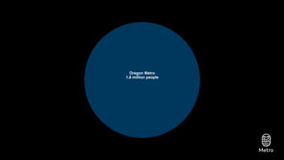
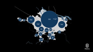
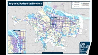
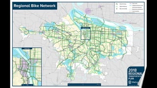
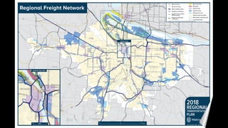
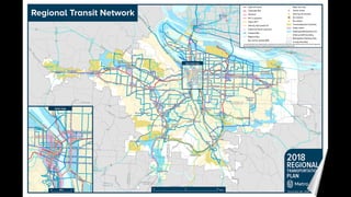
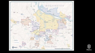
- 2. Oregon Metro 1.8 million people
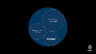
- 3. Oregon Metro 1.8 million people Oregon Metro 1.8 million people Clackamas County 419,425 people Multnomah County 813,300 people Washington County 606,280 people
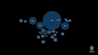
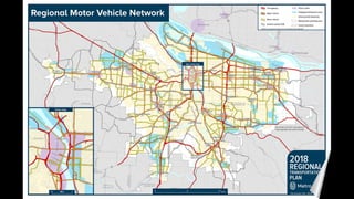
- 4. Oregon Metro 1.8 million people Clackamas County 419,425 people Multnomah County 813,300 people Washington County 606,280 people Rivergrove 505 Durham 1,880 Tigard 52,785 Gladstone 11,880 Happy Valley 20,945 Gresham 110,505 Cornelius 11,935 Beaverton 97,000 Fairview 8,990Forest Grove 24,125 Hillsboro 101,920 Johnson City 560King City 3,700 Lake Oswego 38,215 Maywood Park 750 Milwaukie 20,525 Oregon City 34,860 Portland 648,740 Sherwood 19,505 Troutdale 16,185 Tualatin 27,055 West Linn 25,830 Wilsonville 25,250 Wood Village 3,920 Tigard 52,785 Gladstone 11,880 Happy Valley 20,945 Gresham 110,505 Cornelius 11,935 Beaverton 97,000 Fairview 8,990Forest Grove 24,125 Hillsboro 101,920 Lake Oswego 38,215 Maywood Park 750 Milwaukie 20,525 Oregon City 34,860 Portland 648,740 Sherwood 19,505 Troutdale 16,185 Tualatin 27,055 West Linn 25,830 Wilsonville 25,250 Wood Village
- 5. 0 3 6 Miles Rivergrove 505 Durham 1,880 Tigard 52,785 Gladstone 11,880 Happy Valley 20,945 Gresham 110,505 Cornelius 11,935 Beaverton 97,000 Fairview 8,990Forest Grove 24,125 Hillsboro 101,920 Johnson City 560King City 3,700 Durham 1,880 Johnson City 560King City 3,700 Lake Oswego 38,215 Maywood Park 750 Milwaukie 20,525 Oregon City 34,860 Portland 648,740 Sherwood 19,505 Troutdale 16,185 Tualatin 27,055 West Linn 25,830 Wilsonville 25,250 Wood Village 3,920 Tigard 52,785 Gladstone 11,880 Happy Valley 20,945 Gresham 110,505 Cornelius 11,935 Beaverton 97,000 Fairview 8,990Forest Grove 24,125 Hillsboro 101,920 Lake Oswego 38,215 Maywood Park 750 Milwaukie 20,525 Oregon City 34,860 Portland 648,740 Sherwood 19,505 Troutdale 16,185 Tualatin 27,055 West Linn 25,830 Wilsonville 25,250 Wood Village
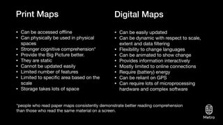
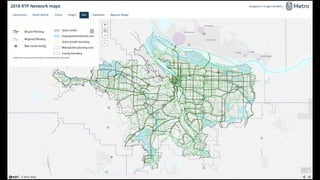
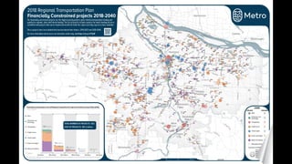
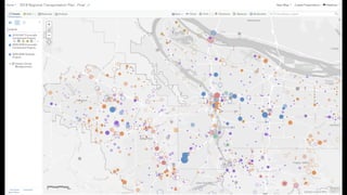
- 6. Print Maps ŌĆó Can be accessed o’¼äine ŌĆó Can physically be used in physical spaces ŌĆó Stronger cognitive comprehension* ŌĆó Provide the Big Picture better. ŌĆó They are static ŌĆó Cannot be updated easily ŌĆó Limited number of features ŌĆó Limited to speci’¼üc area based on the scale ŌĆó Storage takes lots of space ŌĆó Can be easily updated ŌĆó Can be dynamic with respect to scale, extent and data ’¼ültering ŌĆó Flexibility to change languages ŌĆó Can be animated to show change ŌĆó Provides information interactively ŌĆó Mostly limited to online connections ŌĆó Require (battery) energy ŌĆó Can be reliant on GPS ŌĆó Can require lots of microprocessing hardware and complex software Digital Maps *people who read paper maps consistently demonstrate better reading comprehension than those who read the same material on a screen.
- 7. ┬┐Por qu├® no los dos?
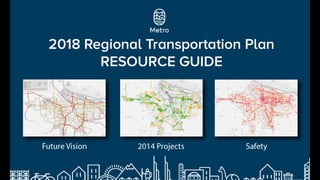
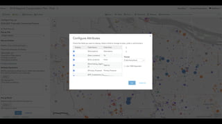
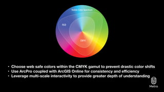
- 30. ŌĆó Choose web safe colors within the CMYK gamut to prevent drastic color shifts ŌĆó Use ArcPro coupled with ArcGIS Online for consistency and e’¼āciency ŌĆó Leverage multi-scale interactivity to provide greater depth of understanding
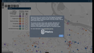
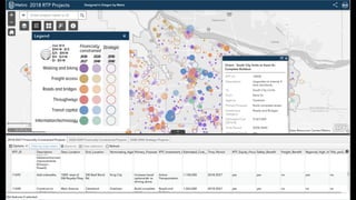
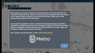
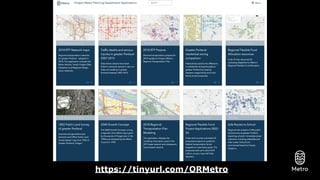
- 31. Gallery of applications now being featured https://tinyurl.com/ORMetro