PPT_Wei
Download as pptx, pdf0 likes193 views

The document analyzes sunlight data from June to August 2010 in Lubbock, Texas and Taipei, Taiwan. It finds that Lubbock had more total hours of sunlight during this period than Taipei. This supports the author's perception that summers seem to never end in Lubbock compared to their home country of Taiwan. Daylight hours vary based on a location's latitude and whether it observes daylight saving time. While the US uses DST, Taiwan has not implemented it since 1976 due to its subtropical location.


PPT_Wei
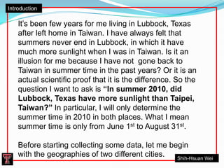
- 1. IntroductionItŌĆÖs been few years for me living in Lubbock, Texas after left home in Taiwan. I have always felt that summers never end in Lubbock, in which it have much more sunlight when I was in Taiwan. Is it an illusion for me because I have not gone back to Taiwan in summer time in the past years? Or it is an actual scientific proof that it is the difference. So the question I want to ask is ŌĆ£In summer 2010, did Lubbock, Texas have more sunlight than Taipei, Taiwan?ŌĆØ In particular, I will only determine the summer time in 2010 in both places. What I mean summer time is only from June 1st to August 31st. Before starting collecting some data, let me begin with the geographies of two different cities. Shih-Hsuan Wei
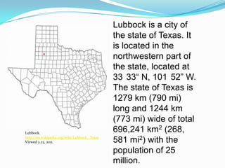
- 2. Lubbock is a city of the state of Texas. It is located in the northwestern part of the state, located at 33┬░33ŌĆ£ N, 101┬░52ŌĆØ W. The state of Texas is 1279 km (790 mi) long and 1244 km (773 mi) wide of total 696,241 km2 (268, 581 mi2) with the population of 25 million. Lubbock. http://en.wikipedia.org/wiki/Lubbock,_TexasViewed 2.23, 2011.
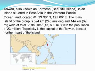
- 3. Taiwan, also known as Formosa (Beautiful Island), is an island situated in East Asia in the Western Pacific Ocean, and located at 23┬░30ŌĆ£ N, 121┬░00ŌĆØ E. The main island of the group is 394 km (245 mi) long and 144 km (89 mi) wide of total 35,980 km2 (13, 892 mi2) with the population of 23 million. Taipei city is the capital of the Taiwan, located northern part of the island. Taiwan.http://en.wikipedia.org/wiki/TaiwanViewed. 2,23, 2011.
- 4. Now we have some idea where Lubbock, Texas and Taipei, Taiwan are. Then we can start finding some data about sunrise and sunset in both cities in 2010. The best resource to collect these data is the Naval Oceanography Portal website http://aa.usno.navy.mil/data/docs/RS_OneYear.php.The U.S. Naval Observatory (USNO) provides a wide range of astronomical data, in particular, you can find table of sunrise/ sunset for an entire year for any location in the world.
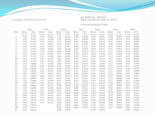
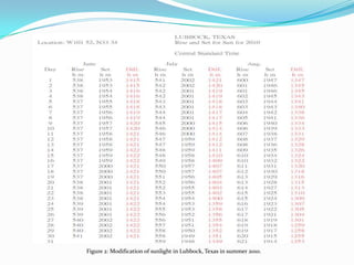
- 5. Start with Lubbock, Texas: Lubbock, sunrise/set.http://aa.usno.navy.mil/data/docs/RS_OneYear.phpViewed. 2,23, 2011.
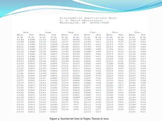
- 7. Figure 1: Sunrise/set time in Lubbock, Texas in 2010.
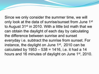
- 8. Since we only consider the summer time, we will only look at the data of sunrise/sunset from June 1st to August 31st in 2010. With a little bid math that we can obtain the daylight of each day by calculating the difference between sunrise and sunset everyday i.e. subtract the sunrise from sunset. For instance, the daylight on June 1st, 2010 can be calculated by 1953 ŌĆō 538 = 1416, i.e. it had a 14 hours and 16 minutes of daylight on June 1st, 2010.
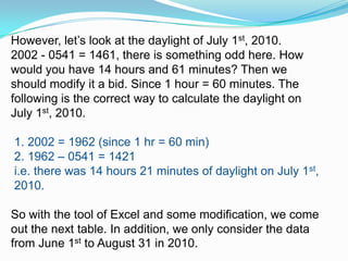
- 9. However, letŌĆÖs look at the daylight of July 1st, 2010. 2002 - 0541 = 1461, there is something odd here. How would you have 14 hours and 61 minutes? Then we should modify it a bid. Since 1 hour = 60 minutes. The following is the correct way to calculate the daylight on July 1st, 2010. 1. 2002 = 1962 (since 1 hr = 60 min) 2. 1962 ŌĆō 0541 = 1421 i.e. there was 14 hours 21 minutes of daylight on July 1st, 2010. So with the tool of Excel and some modification, we come out the next table. In addition, we only consider the data from June 1st to August 31 in 2010.
- 10. Figure 2: Modification of sunlight in Lubbock, Texas in summer 2010.
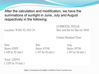
- 11. After the calculation and modification, we have the summations of sunlight in June, July and August respectively in the following. Figure 3: Summation of sunlight in Lubbock, Texas in summer 2010.
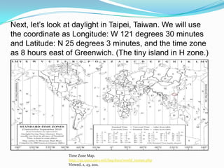
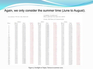
- 12. Next, letŌĆÖs look at daylight in Taipei, Taiwan. We will use the coordinate as Longitude: W 121 degrees 30 minutes and Latitude: N 25 degrees 3 minutes, and the time zone as 8 hours east of Greenwich. (The tiny island in H zone.) Time Zone Map.http://aa.usno.navy.mil/faq/docs/world_tzones.phpViewed. 2, 23, 2011.
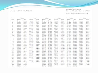
- 15. Figure 4: Sunrise/set time in Taipei, Taiwan in 2010.
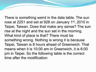
- 16. There is something weird in the data table. The sun rose at 2251 and set at 928 on January 1st, 2010 in Taipei, Taiwan. Does that make any sense? The sun rise at the night and the sun set in the morning. What kind of place is that? There must be something wrong. Nothing is wrong it is because Taipei, Taiwan is 8 hours ahead of Greenwich. That means when it is 10:00 am in Greenwich, it is 6:00 pm in Taipei. So the following table is the correct time after the modification.
- 17. Again, we only consider the summer time (June to August). Figure 5: Sunlight in Taipei, Taiwan in summer 2010.
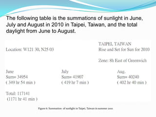
- 18. The following table is the summations of sunlight in June, July and August in 2010 in Taipei, Taiwan, and the total daylight from June to August. Figure 6: Summation of sunlight in Taipei, Taiwan in summer 2010.
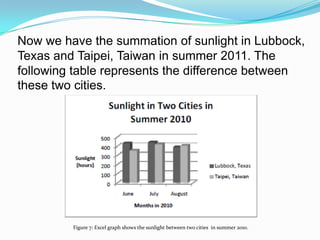
- 19. Now we have the summation of sunlight in Lubbock, Texas and Taipei, Taiwan in summer 2011. The following table represents the difference between these two cities. Figure 7: Excel graph shows the sunlight between two cities in summer 2010.
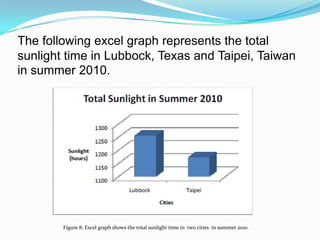
- 20. The following excel graph represents the total sunlight time in Lubbock, Texas and Taipei, Taiwan in summer 2010. Figure 8: Excel graph shows the total sunlight time in two cities in summer 2010.
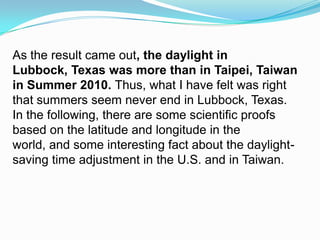
- 21. As the result came out, the daylight in Lubbock, Texas was more than in Taipei, Taiwan in Summer 2010. Thus,what I have felt was right that summers seem never end in Lubbock, Texas. In the following, there are some scientific proofs based on the latitude and longitude in the world, and some interesting fact about the daylight-saving time adjustment in the U.S. and in Taiwan.
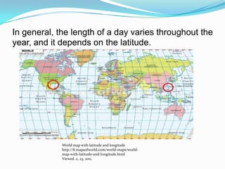
- 22. In general, the length of a day varies throughout the year, and it depends on the latitude.World map with latitude and longitudehttp://fr.mapsofworld.com/world-maps/world-map-with-latitude-and-longitude.htmlViewed. 2, 23, 2011.
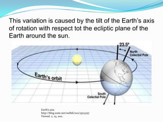
- 23. This variation is caused by the tilt of the EarthŌĆÖs axis of rotation with respect tot the ecliptic plane of the Earth around the sun. EarthŌĆÖs axis. http://blog.xuite.net/wellsli/002/35113257Viewed. 2, 23, 2011.
- 24. Because the EarthŌĆÖs revolution around the sun on one side, while around its axis. The axis with the public-axis orbital plane into 66.5 degrees angle, making the EarthŌĆÖs movement in orbit, and with different relative position of the sun that varies the existence point between the Tropic of Cancer. Before coming to the U.S., I know the time difference between the U.S. and Taiwan would be adjusted for summers and winters. For example, the time difference between California and Taiwan in summer is 15 hours, but it becomes 16 hours in the winter.
- 25. When I needed to call my friends in Los Angles, California, I had to call at midnight in Taiwan, and IŌĆÖd have to call around 1 in morning in the winter. This is because of the daylight-saving time (DST) adjustment, the summer sunlight has longer time in higher latitudes. Typically clocks are adjusted forward one hour in the spring and are adjusted backward in autumn . It is the practice of temporarily advancing clocks during the summertime so that afternoons have more daylight and mornings have less.
- 26. Currently, there are about 110 countries around the world using daylight-saving time. Since the season in southern hemisphere is opposite to the northern hemisphere, DST are adjusted oppositely during the seasons. The countries in low-latitude have relatively fixed duration of sunshine, there is no need for DST. Does the small island like Taiwan have DST? No, no any more. But there were some researches said Taiwan had DST before.
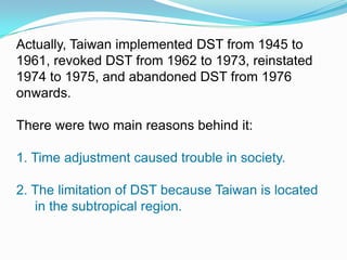
- 27. Actually, Taiwan implemented DST from 1945 to 1961, revoked DST from 1962 to 1973, reinstated 1974 to 1975, and abandoned DST from 1976 onwards. There were two main reasons behind it:1. Time adjustment caused trouble in society.2. The limitation of DST because Taiwan is located in the subtropical region.
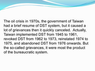
- 28. The oil crisis in 1970s, the government of Taiwan had a brief resume of DST system, but it caused a lot of grievances then it quickly canceled. Actually, Taiwan implemented DST from 1945 to 1961, revoked DST from 1962 to 1973, reinstated 1974 to 1975, and abandoned DST from 1976 onwards. But the so-called grievances, it were most the product of the bureaucratic system.
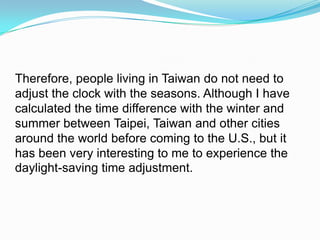
- 29. Therefore, people living in Taiwan do not need to adjust the clock with the seasons. Although I have calculated the time difference with the winter and summer between Taipei, Taiwan and other cities around the world before coming to the U.S., but it has been very interesting to me to experience the daylight-saving time adjustment.
- 30. ReferencesDay length. Retrieved February 25, 2011, from http://en.wikipedia.org/wiki/Day_length .Geographic Names Information System. Retrieved February 23, 2011, from http://geonames.usgs.gov/pls/gnispublic/f?p=154:1:413510313315132 Geography of Lubbock, Texas. Retrieved February 22, 2011, from http://en.wikipedia.org/wiki/Lubbock,_Texas. Geography of Taiwan. Retrieved February 22, 2011, from http://en.wikipedia.org/wiki/Geography_of_Taiwan. Latitude and Longitude. Retrieved February 23, 2011, from http://blog.xuite.net/wellsli/002/35113257.
- 31. ReferencesMap of World.com. Retrieved February 21, 2011, from http://fr.mapsofworld.com/world-maps/world-map-with-latitude-and-longitude.html .National Geospatial-Intelligence Agency. Retrieved February 22, 2011, from http://earth-info.nga.mil/gns/html/index.html.National Science Teachers Association. Retrieved February 22, 2011, from http://learningcenter.nsta.org/?lid=tnavhp.U. S. Naval Observatory. Retrieved February 24, 2011, from http://aa.usno.navy.mil/ data/. Time difference between Taipei and Greenwich. Retrieved February 23, 2011, from http://www.happyzebra.com/timezones-worldclock/difference-between-Taipei-and-Greenwich%20Borough.php.