
Site Analysis
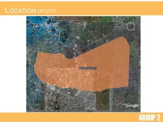
- 2. L OCATION OF CITY
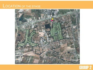
- 3. L OCATION OF THE STAGE
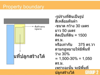
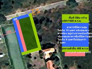
- 6. - ÓĖŻÓĖ╣ÓĖøÓĖŻÓ╣łÓĖ▓ÓĖćÓĖŚÓĖĄÓ╣łÓĖöÓĖ┤ÓĖÖÓ╣ĆÓĖøÓ╣ćÓĖÖÓĖŻÓĖ╣ÓĖøÓĖ¬ÓĖĄÓ╣łÓ╣ĆÓĖ½ÓĖźÓĖĄÓ╣łÓĖóÓĖĪÓĖ£ÓĖĘÓĖÖÓĖ£Ó╣ēÓĖ▓ - ÓĖéÓĖÖÓĖ▓ÓĖö ÓĖüÓĖ¦Ó╣ēÓĖ▓ÓĖć 30 Ó╣ĆÓĖĪÓĖĢÓĖŻ ÓĖóÓĖ▓ÓĖ¦ 50 Ó╣ĆÓĖĪÓĖĢÓĖŻ ÓĖäÓĖ┤ÓĖöÓ╣ĆÓĖøÓ╣ćÓĖÖÓĖŚÓĖĄÓ╣łÓĖöÓĖ┤ÓĖÖ = 1500 ÓĖĢÓĖŻ . ÓĖĪ . ÓĖ½ÓĖŻÓĖĘÓĖŁÓ╣ĆÓĖŚÓ╣łÓĖ▓ÓĖüÓĖ▒ÓĖÜ 375 ÓĖĢÓĖŻ . ÓĖ¦ÓĖ▓ ÓĖĢÓĖ▓ÓĖĪÓĖüÓĖÄÓĖ½ÓĖĪÓĖ▓ÓĖóÓ╣āÓĖ½Ó╣ēÓĖĪÓĖĄÓĖ×ÓĖĘÓ╣ēÓĖÖÓĖŚÓĖĄÓ╣łÓĖ¦Ó╣łÓĖ▓ÓĖć 30 % = 1 , 500-30% = 1,050 ÓĖĢÓĖŻ . ÓĖĪ . Ó╣ĆÓĖ×ÓĖŻÓĖ▓ÓĖ░ÓĖēÓĖ░ÓĖÖÓĖ▒Ó╣ēÓĖÖ ÓĖłÓĖ░ÓĖĪÓĖĄÓĖ×ÓĖĘÓ╣ēÓĖÖÓĖŚÓĖĄÓ╣łÓĖøÓĖźÓĖ╣ÓĖüÓĖ¬ÓĖŻÓ╣ēÓĖ▓ÓĖćÓ╣äÓĖöÓ╣ē = 1 , 050 ÓĖĢÓĖŻ . ÓĖĪ . ÓĖ½ÓĖŻÓĖĘÓĖŁÓ╣ĆÓĖŚÓ╣łÓĖ▓ÓĖüÓĖ▒ÓĖÜ 262.5 ÓĖĢÓĖŻ . ÓĖ¦ÓĖ▓ ÓĖ×ÓĖĘÓ╣ēÓĖÖÓĖŚÓĖĄÓ╣łÓĖĢÓ╣ēÓĖŁÓĖćÓ╣ĆÓĖøÓ╣ćÓĖÖÓĖŚÓĖĄÓ╣łÓĖ¦Ó╣łÓĖ▓ÓĖćÓĖĢÓĖ▓ÓĖĪÓĖüÓĖÄÓĖ½ÓĖĪÓĖ▓ÓĖó Ó╣ĆÓĖŚÓ╣łÓĖ▓ÓĖüÓĖ▒ÓĖÜ 450 ÓĖĢÓĖŻ . ÓĖĪ . ÓĖ½ÓĖŻÓĖĘÓĖŁ 112.5 ÓĖĢÓĖŻ . ÓĖ¦ÓĖ▓ ÓĖ×ÓĖĘÓ╣ēÓĖÖÓĖŚÓĖĄÓ╣łÓĖ¦Ó╣łÓĖ▓ÓĖćÓĖĢÓĖ▓ÓĖĪÓĖüÓĖÄÓĖ½ÓĖĪÓĖ▓ÓĖó ÓĖ×ÓĖĘÓ╣ēÓĖÖÓĖŚÓĖĄÓ╣łÓĖøÓĖźÓĖ╣ÓĖüÓĖ¬ÓĖŻÓ╣ēÓĖ▓ÓĖćÓ╣äÓĖöÓ╣ē Property boundary
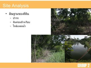
- 7. Site Analysis ÓĖ¬ÓĖ▒ÓĖōÓĖÉÓĖ▓ÓĖÖÓĖéÓĖŁÓĖćÓĖŚÓĖĄÓ╣łÓĖöÓĖ┤ÓĖÖ ÓĖøÓ╣łÓĖ▓ÓĖŻÓĖü ÓĖöÓĖ┤ÓĖÖÓĖäÓ╣łÓĖŁÓĖÖÓĖéÓ╣ēÓĖ▓ÓĖćÓ╣ĆÓĖŻÓĖĄÓĖóÓĖÜ Ó╣āÓĖüÓĖźÓ╣ēÓ╣üÓĖ½ÓĖźÓ╣łÓĖćÓĖÖÓ╣ēÓĖ│
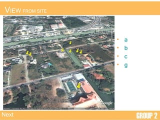
- 8. V IEW FROM SITE a b c g Next
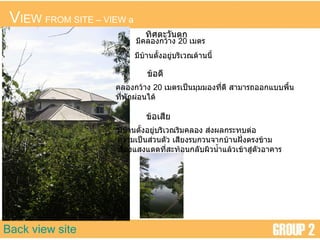
- 9. V IEW FROM SITE ŌĆō VIEW a Back view site ÓĖŚÓĖ┤ÓĖ©ÓĖĢÓĖ░ÓĖ¦ÓĖ▒ÓĖÖÓĖĢÓĖü ÓĖĪÓĖĄÓĖäÓĖźÓĖŁÓĖćÓĖüÓĖ¦Ó╣ēÓĖ▓ÓĖć 20 Ó╣ĆÓĖĪÓĖĢÓĖŻ ÓĖĪÓĖĄÓĖÜÓ╣ēÓĖ▓ÓĖÖÓĖĢÓĖ▒Ó╣ēÓĖćÓĖŁÓĖóÓĖ╣Ó╣łÓĖÜÓĖŻÓĖ┤Ó╣ĆÓĖ¦ÓĖōÓĖöÓ╣ēÓĖ▓ÓĖÖÓĖÖÓĖĄÓ╣ē ÓĖéÓ╣ēÓĖŁÓĖöÓĖĄ ÓĖäÓĖźÓĖŁÓĖćÓĖüÓĖ¦Ó╣ēÓĖ▓ÓĖć 20 Ó╣ĆÓĖĪÓĖĢÓĖŻÓ╣ĆÓĖøÓ╣ćÓĖÖÓĖĪÓĖĖÓĖĪÓĖĪÓĖŁÓĖćÓĖŚÓĖĄÓ╣łÓĖöÓĖĄ ÓĖ¬ÓĖ▓ÓĖĪÓĖ▓ÓĖŻÓĖ¢ÓĖŁÓĖŁÓĖüÓ╣üÓĖÜÓĖÜÓĖ×ÓĖĘÓ╣ēÓĖÖ ÓĖŚÓĖĄÓ╣łÓĖ×ÓĖ▒ÓĖüÓĖ£Ó╣łÓĖŁÓĖÖÓ╣äÓĖöÓ╣ē ÓĖéÓ╣ēÓĖŁÓ╣ĆÓĖ¬ÓĖĄÓĖó ÓĖĪÓĖĄÓĖÜÓ╣ēÓĖ▓ÓĖÖÓĖĢÓĖ▒Ó╣ēÓĖćÓĖŁÓĖóÓĖ╣Ó╣łÓĖÜÓĖŻÓĖ┤Ó╣ĆÓĖ¦ÓĖōÓĖŻÓĖ┤ÓĖĪÓĖäÓĖźÓĖŁÓĖć ÓĖ¬Ó╣łÓĖćÓĖ£ÓĖźÓĖüÓĖŻÓĖ░ÓĖŚÓĖÜÓĖĢÓ╣łÓĖŁ ÓĖäÓĖ¦ÓĖ▓ÓĖĪÓ╣ĆÓĖøÓ╣ćÓĖÖÓĖ¬Ó╣łÓĖ¦ÓĖÖÓĖĢÓĖ▒ÓĖ¦ Ó╣ĆÓĖ¬ÓĖĄÓĖóÓĖćÓĖŻÓĖÜÓĖüÓĖ¦ÓĖÖÓĖłÓĖ▓ÓĖüÓĖÜÓ╣ēÓĖ▓ÓĖÖÓĖØÓĖ▒Ó╣łÓĖćÓĖĢÓĖŻÓĖćÓĖéÓ╣ēÓĖ▓ÓĖĪ Ó╣ĆÓĖŻÓĖĘÓ╣łÓĖŁÓĖćÓ╣üÓĖ¬ÓĖćÓ╣üÓĖöÓĖöÓĖŚÓĖĄÓ╣łÓĖ¬ÓĖ░ÓĖŚÓ╣ēÓĖŁÓĖÖÓĖüÓĖźÓĖ▒ÓĖÜÓĖ£ÓĖ┤ÓĖ¦ÓĖÖÓ╣ēÓĖ│Ó╣üÓĖźÓ╣ēÓĖ¦Ó╣ĆÓĖéÓ╣ēÓĖ▓ÓĖ¬ÓĖ╣Ó╣łÓĖĢÓĖ▒ÓĖ¦ÓĖŁÓĖ▓ÓĖäÓĖ▓ÓĖŻ
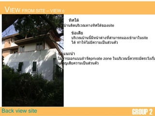
- 10. V IEW FROM SITE ŌĆō VIEW c Back view site ÓĖŚÓĖ┤ÓĖ©Ó╣āÓĖĢÓ╣ē ÓĖĪÓĖĄÓĖÜÓ╣ēÓĖ▓ÓĖÖÓĖĢÓĖ┤ÓĖöÓĖÜÓĖŻÓĖ┤Ó╣ĆÓĖ¦ÓĖōÓĖŚÓĖ▓ÓĖćÓĖŚÓĖ┤ÓĖ©Ó╣āÓĖĢÓ╣ēÓĖéÓĖŁÓĖć site ÓĖéÓ╣ēÓĖŁÓ╣ĆÓĖ¬ÓĖĄÓĖó ÓĖÜÓĖŻÓĖ┤Ó╣ĆÓĖ¦ÓĖōÓĖÜÓ╣ēÓĖ▓ÓĖÖÓĖÖÓĖĄÓ╣ēÓĖĪÓĖĄÓĖ½ÓĖÖÓ╣ēÓĖ▓ÓĖĢÓ╣łÓĖ▓ÓĖćÓĖŚÓĖĄÓ╣łÓĖ¬ÓĖ▓ÓĖĪÓĖ▓ÓĖŻÓĖ¢ÓĖĪÓĖŁÓĖćÓ╣ĆÓĖéÓ╣ēÓĖ▓ÓĖĪÓĖ▓Ó╣āÓĖÖ site Ó╣äÓĖöÓ╣ē ÓĖŚÓĖ│Ó╣āÓĖ½Ó╣ēÓ╣äÓĖĪÓ╣łÓĖĪÓĖĄÓĖäÓĖ¦ÓĖ▓ÓĖĪÓ╣ĆÓĖøÓ╣ćÓĖÖÓĖ¬Ó╣łÓĖ¦ÓĖÖÓĖĢÓĖ▒ÓĖ¦ ÓĖéÓ╣ēÓĖŁÓ╣üÓĖÖÓĖ░ÓĖÖÓĖ│ Ó╣āÓĖÖÓĖüÓĖ▓ÓĖŻÓĖŁÓĖŁÓĖüÓ╣üÓĖÜÓĖÜÓĖ¢Ó╣ēÓĖ▓ÓĖłÓĖ▒ÓĖö private zone Ó╣āÓĖÖÓĖÜÓĖŻÓĖ┤Ó╣ĆÓĖ¦ÓĖōÓĖÖÓĖĄÓ╣ēÓĖäÓĖ¦ÓĖŻÓĖŻÓĖ░ÓĖĪÓĖ▒ÓĖöÓĖŻÓĖ░ÓĖ¦ÓĖ▒ÓĖćÓ╣ĆÓĖŻÓĖĘÓ╣łÓĖŁÓĖć ÓĖłÓĖ░ÓĖ¬ÓĖ╣ÓĖŹÓ╣ĆÓĖ¬ÓĖĄÓĖóÓĖäÓĖ¦ÓĖ▓ÓĖĪÓ╣ĆÓĖøÓ╣ćÓĖÖÓĖ¬Ó╣łÓĖ¦ÓĖÖÓĖĢÓĖ▒ÓĖ¦
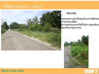
- 11. V IEW FROM SITE ŌĆō VIEW g Back view site ÓĖŚÓĖ┤ÓĖ©Ó╣ĆÓĖ½ÓĖÖÓĖĘÓĖŁ ÓĖÜÓĖŻÓĖ┤Ó╣ĆÓĖ¦ÓĖōÓĖ¢ÓĖÖÓĖÖÓĖŚÓĖ▓ÓĖćÓ╣ĆÓĖéÓ╣ēÓĖ▓ÓĖŚÓĖ▒Ó╣ēÓĖćÓĖ¬ÓĖŁÓĖćÓĖéÓ╣ēÓĖ▓ÓĖćÓĖŚÓĖ▓ÓĖćÓĖĪÓĖĄÓĖźÓĖ▒ÓĖüÓĖ®ÓĖōÓĖ░ Ó╣ĆÓĖøÓ╣ćÓĖÖÓĖøÓ╣łÓĖ▓ÓĖŻÓĖüÓ╣üÓĖźÓĖ░Ó╣ĆÓĖøÓĖźÓĖĄÓ╣łÓĖóÓĖ¦ Ó╣āÓĖÖÓĖüÓĖ▓ÓĖŻÓĖŁÓĖŁÓĖüÓ╣üÓĖÜÓĖÜÓĖäÓĖ¦ÓĖŻÓ╣āÓĖ½Ó╣ēÓĖŻÓĖ▒Ó╣ēÓĖ¦ÓĖĪÓĖĄÓĖäÓĖ¦ÓĖ▓ÓĖĪÓĖ¬ÓĖ╣ÓĖćÓ╣ĆÓĖ×ÓĖĄÓĖóÓĖćÓĖ×ÓĖŁ Ó╣ĆÓĖ×ÓĖĘÓ╣łÓĖŁÓĖøÓ╣ēÓĖŁÓĖćÓĖüÓĖ▒ÓĖÖÓĖŁÓĖ▓ÓĖŖÓĖŹÓĖ▓ÓĖüÓĖŻÓĖŻÓĖĪ
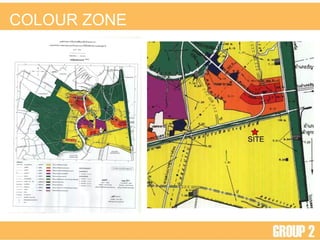
- 13. LAW
- 14. COLOUR ZONE
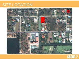
- 15. SITE LOCATION
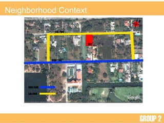
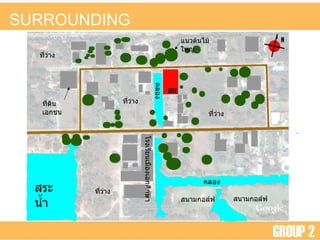
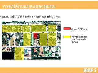
- 16. SURROUNDING Ó╣éÓĖŻÓĖćÓ╣ĆÓĖŻÓĖĄÓĖóÓĖÖÓ╣ĆÓĖĪÓĖĘÓĖŁÓĖćÓ╣ĆÓĖŁÓĖüÓĖ©ÓĖČÓĖüÓĖ®ÓĖ▓ Ó╣üÓĖÖÓĖ¦ÓĖĢÓ╣ēÓĖÖÓ╣äÓĖĪÓ╣ēÓ╣āÓĖ½ÓĖŹÓ╣ł ÓĖ¬ÓĖÖÓĖ▓ÓĖĪÓĖüÓĖŁÓĖźÓ╣īÓĖ¤ ÓĖ¬ÓĖŻÓĖ░ÓĖÖÓ╣ēÓĖ│ ÓĖäÓĖźÓĖŁÓĖć ÓĖäÓĖźÓĖŁÓĖć ÓĖŚÓĖĄÓ╣łÓĖöÓĖ┤ÓĖÖÓ╣ĆÓĖŁÓĖüÓĖŖÓĖÖ ÓĖŚÓĖĄÓ╣łÓĖ¦Ó╣łÓĖ▓ÓĖć ÓĖŚÓĖĄÓ╣łÓĖ¦Ó╣łÓĖ▓ÓĖć ÓĖŚÓĖĄÓ╣łÓĖ¦Ó╣łÓĖ▓ÓĖć ÓĖŚÓĖĄÓ╣łÓĖ¦Ó╣łÓĖ▓ÓĖć ÓĖ¬ÓĖÖÓĖ▓ÓĖĪÓĖüÓĖŁÓĖźÓ╣īÓĖ¤
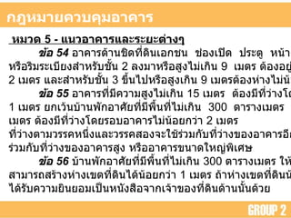
- 17. ÓĖüÓĖÄÓĖ½ÓĖĪÓĖ▓ÓĖóÓĖäÓĖ¦ÓĖÜÓĖäÓĖĖÓĖĪÓĖŁÓĖ▓ÓĖäÓĖ▓ÓĖŻ ÓĖ½ÓĖĪÓĖ¦ÓĖö 5 - Ó╣üÓĖÖÓĖ¦ÓĖŁÓĖ▓ÓĖäÓĖ▓ÓĖŻÓ╣üÓĖźÓĖ░ÓĖŻÓĖ░ÓĖóÓĖ░ÓĖĢÓ╣łÓĖ▓ÓĖćÓ╣å ÓĖéÓ╣ēÓĖŁ 54 ÓĖŁÓĖ▓ÓĖäÓĖ▓ÓĖŻÓĖöÓ╣ēÓĖ▓ÓĖÖÓĖŖÓĖ┤ÓĖöÓĖŚÓĖĄÓ╣łÓĖöÓĖ┤ÓĖÖÓ╣ĆÓĖŁÓĖüÓĖŖÓĖÖ ÓĖŖÓ╣łÓĖŁÓĖćÓ╣ĆÓĖøÓĖ┤ÓĖö ÓĖøÓĖŻÓĖ░ÓĖĢÓĖ╣ ÓĖ½ÓĖÖÓ╣ēÓĖ▓ÓĖĢÓ╣łÓĖ▓ÓĖć ÓĖŖÓ╣łÓĖŁÓĖćÓĖŻÓĖ░ÓĖÜÓĖ▓ÓĖóÓĖŁÓĖ▓ÓĖüÓĖ▓ÓĖ© ÓĖ½ÓĖŻÓĖĘÓĖŁÓĖŻÓĖ┤ÓĖĪÓĖŻÓĖ░Ó╣ĆÓĖÜÓĖĄÓĖóÓĖćÓĖ¬ÓĖ│ÓĖ½ÓĖŻÓĖ▒ÓĖÜÓĖŖÓĖ▒Ó╣ēÓĖÖ 2 ÓĖźÓĖćÓĖĪÓĖ▓ÓĖ½ÓĖŻÓĖĘÓĖŁÓĖ¬ÓĖ╣ÓĖćÓ╣äÓĖĪÓ╣łÓ╣ĆÓĖüÓĖ┤ÓĖÖ 9 Ó╣ĆÓĖĪÓĖĢÓĖŻ ÓĖĢÓ╣ēÓĖŁÓĖćÓĖŁÓĖóÓĖ╣Ó╣łÓĖ½Ó╣łÓĖ▓ÓĖćÓ╣ĆÓĖéÓĖĢÓĖŚÓĖĄÓ╣łÓĖöÓĖ┤ÓĖÖÓ╣äÓĖĪÓ╣łÓĖÖÓ╣ēÓĖŁÓĖóÓĖüÓĖ¦Ó╣łÓĖ▓ 2 Ó╣ĆÓĖĪÓĖĢÓĖŻ Ó╣üÓĖźÓĖ░ÓĖ¬ÓĖ│ÓĖ½ÓĖŻÓĖ▒ÓĖÜÓĖŖÓĖ▒Ó╣ēÓĖÖ 3 ÓĖéÓĖČÓ╣ēÓĖÖÓ╣äÓĖøÓĖ½ÓĖŻÓĖĘÓĖŁÓĖ¬ÓĖ╣ÓĖćÓ╣ĆÓĖüÓĖ┤ÓĖÖ 9 Ó╣ĆÓĖĪÓĖĢÓĖŻÓĖĢÓ╣ēÓĖŁÓĖćÓĖ½Ó╣łÓĖ▓ÓĖćÓ╣äÓĖĪÓ╣łÓĖÖÓ╣ēÓĖŁÓĖóÓĖüÓĖ¦Ó╣łÓĖ▓ 3 Ó╣ĆÓĖĪÓĖĢÓĖŻ ÓĖéÓ╣ēÓĖŁ 55 ÓĖŁÓĖ▓ÓĖäÓĖ▓ÓĖŻÓĖŚÓĖĄÓ╣łÓĖĪÓĖĄÓĖäÓĖ¦ÓĖ▓ÓĖĪÓĖ¬ÓĖ╣ÓĖćÓ╣äÓĖĪÓ╣łÓ╣ĆÓĖüÓĖ┤ÓĖÖ 15 Ó╣ĆÓĖĪÓĖĢÓĖŻ ÓĖĢÓ╣ēÓĖŁÓĖćÓĖĪÓĖĄÓĖŚÓĖĄÓ╣łÓĖ¦Ó╣łÓĖ▓ÓĖćÓ╣éÓĖöÓĖóÓĖŻÓĖŁÓĖÜÓĖŁÓĖ▓ÓĖäÓĖ▓ÓĖŻÓ╣äÓĖĪÓ╣łÓĖÖÓ╣ēÓĖŁÓĖóÓĖüÓĖ¦Ó╣łÓĖ▓ 1 Ó╣ĆÓĖĪÓĖĢÓĖŻ ÓĖóÓĖüÓ╣ĆÓĖ¦Ó╣ēÓĖÖÓĖÜÓ╣ēÓĖ▓ÓĖÖÓĖ×ÓĖ▒ÓĖüÓĖŁÓĖ▓ÓĖ©ÓĖ▒ÓĖóÓĖŚÓĖĄÓ╣łÓĖĪÓĖĄÓĖ×ÓĖĘÓ╣ēÓĖÖÓĖŚÓĖĄÓ╣łÓ╣äÓĖĪÓ╣łÓ╣ĆÓĖüÓĖ┤ÓĖÖ 300 ÓĖĢÓĖ▓ÓĖŻÓĖ▓ÓĖćÓ╣ĆÓĖĪÓĖĢÓĖŻ ÓĖŁÓĖ▓ÓĖäÓĖ▓ÓĖŻÓĖŚÓĖĄÓ╣łÓĖĪÓĖĄÓĖäÓĖ¦ÓĖ▓ÓĖĪÓĖ¬ÓĖ╣ÓĖćÓ╣ĆÓĖüÓĖ┤ÓĖÖ 15 Ó╣ĆÓĖĪÓĖĢÓĖŻ ÓĖĢÓ╣ēÓĖŁÓĖćÓĖĪÓĖĄÓĖŚÓĖĄÓ╣łÓĖ¦Ó╣łÓĖ▓ÓĖćÓ╣éÓĖöÓĖóÓĖŻÓĖŁÓĖÜÓĖŁÓĖ▓ÓĖäÓĖ▓ÓĖŻÓ╣äÓĖĪÓ╣łÓĖÖÓ╣ēÓĖŁÓĖóÓĖüÓĖ¦Ó╣łÓĖ▓ 2 Ó╣ĆÓĖĪÓĖĢÓĖŻ ÓĖŚÓĖĄÓ╣łÓĖ¦Ó╣łÓĖ▓ÓĖćÓĖĢÓĖ▓ÓĖĪÓĖ¦ÓĖŻÓĖŻÓĖäÓĖ½ÓĖÖÓĖČÓ╣łÓĖćÓ╣üÓĖźÓĖ░ÓĖ¦ÓĖŻÓĖŻÓĖäÓĖ¬ÓĖŁÓĖćÓĖłÓĖ░Ó╣āÓĖŖÓ╣ēÓĖŻÓ╣łÓĖ¦ÓĖĪÓĖüÓĖ▒ÓĖÜÓĖŚÓĖĄÓ╣łÓĖ¦Ó╣łÓĖ▓ÓĖćÓĖéÓĖŁÓĖćÓĖŁÓĖ▓ÓĖäÓĖ▓ÓĖŻÓĖŁÓĖĄÓĖüÓĖ½ÓĖźÓĖ▒ÓĖćÓĖ½ÓĖÖÓĖČÓ╣łÓĖćÓ╣äÓĖĪÓ╣łÓ╣äÓĖöÓ╣ē Ó╣ĆÓĖ¦Ó╣ēÓĖÖÓ╣üÓĖĢÓ╣łÓ╣āÓĖŖÓ╣ē ÓĖŻÓ╣łÓĖ¦ÓĖĪÓĖüÓĖ▒ÓĖÜÓĖŚÓĖĄÓ╣łÓĖ¦Ó╣łÓĖ▓ÓĖćÓĖéÓĖŁÓĖćÓĖŁÓĖ▓ÓĖäÓĖ▓ÓĖŻÓĖ¬ÓĖ╣ÓĖć ÓĖ½ÓĖŻÓĖĘÓĖŁÓĖŁÓĖ▓ÓĖäÓĖ▓ÓĖŻÓĖéÓĖÖÓĖ▓ÓĖöÓ╣āÓĖ½ÓĖŹÓ╣łÓĖ×ÓĖ┤Ó╣ĆÓĖ©ÓĖ® ÓĖéÓ╣ēÓĖŁ 56 ÓĖÜÓ╣ēÓĖ▓ÓĖÖÓĖ×ÓĖ▒ÓĖüÓĖŁÓĖ▓ÓĖ©ÓĖ▒ÓĖóÓĖŚÓĖĄÓ╣łÓĖĪÓĖĄÓĖ×ÓĖĘÓ╣ēÓĖÖÓĖŚÓĖĄÓ╣łÓ╣äÓĖĪÓ╣łÓ╣ĆÓĖüÓĖ┤ÓĖÖ 300 ÓĖĢÓĖ▓ÓĖŻÓĖ▓ÓĖćÓ╣ĆÓĖĪÓĖĢÓĖŻ Ó╣āÓĖ½Ó╣ēÓĖ£ÓĖÖÓĖ▒ÓĖćÓĖöÓ╣ēÓĖ▓ÓĖÖÓĖŚÓĖĄÓ╣łÓ╣äÓĖĪÓ╣łÓĖĪÓĖĄÓĖŖÓ╣łÓĖŁÓĖćÓ╣ĆÓĖøÓĖ┤ÓĖö ÓĖ¬ÓĖ▓ÓĖĪÓĖ▓ÓĖŻÓĖ¢ÓĖ¬ÓĖŻÓ╣ēÓĖ▓ÓĖćÓĖ½Ó╣łÓĖ▓ÓĖćÓ╣ĆÓĖéÓĖĢÓĖŚÓĖĄÓ╣łÓĖöÓĖ┤ÓĖÖÓ╣äÓĖöÓ╣ēÓĖÖÓ╣ēÓĖŁÓĖóÓĖüÓĖ¦Ó╣łÓĖ▓ 1 Ó╣ĆÓĖĪÓĖĢÓĖŻ ÓĖ¢Ó╣ēÓĖ▓ÓĖ½Ó╣łÓĖ▓ÓĖćÓ╣ĆÓĖéÓĖĢÓĖŚÓĖĄÓ╣łÓĖöÓĖ┤ÓĖÖÓĖÖÓ╣ēÓĖŁÓĖóÓĖüÓĖ¦Ó╣łÓĖ▓ 50 Ó╣ĆÓĖŗÓĖÖÓĖĢÓĖ┤Ó╣ĆÓĖĪÓĖĢÓĖŻ ÓĖĢÓ╣ēÓĖŁÓĖć Ó╣äÓĖöÓ╣ēÓĖŻÓĖ▒ÓĖÜÓĖäÓĖ¦ÓĖ▓ÓĖĪÓĖóÓĖ┤ÓĖÖÓĖóÓĖŁÓĖĪÓ╣ĆÓĖøÓ╣ćÓĖÖÓĖ½ÓĖÖÓĖ▒ÓĖćÓĖ¬ÓĖĘÓĖŁÓĖłÓĖ▓ÓĖüÓ╣ĆÓĖłÓ╣ēÓĖ▓ÓĖéÓĖŁÓĖćÓĖŚÓĖĄÓ╣łÓĖöÓĖ┤ÓĖÖÓĖöÓ╣ēÓĖ▓ÓĖÖÓĖÖÓĖ▒Ó╣ēÓĖÖÓĖöÓ╣ēÓĖ¦ÓĖó
- 18. ÓĖŁÓĖ▓ÓĖäÓĖ▓ÓĖŻÓĖŚÓĖĄÓ╣łÓĖüÓ╣łÓĖŁ ÓĖ¬ÓĖŻÓ╣ēÓĖ▓ÓĖć ÓĖ½ÓĖŻÓĖĘÓĖŁ ÓĖöÓĖ▒ÓĖöÓ╣üÓĖøÓĖźÓĖć Ó╣āÓĖüÓĖźÓ╣ēÓ╣üÓĖ½ÓĖźÓ╣łÓĖć ÓĖÖÓ╣ēÓĖ│ÓĖ¬ÓĖ▓ÓĖśÓĖ▓ÓĖŻ - ÓĖōÓĖ░ Ó╣ĆÓĖŖÓ╣łÓĖÖ Ó╣üÓĖĪÓ╣łÓĖÖÓ╣ēÓĖ│ ÓĖäÓĖ╣ ÓĖäÓĖźÓĖŁÓĖć ÓĖźÓĖ│ÓĖśÓĖ▓ÓĖŻ ÓĖŚÓĖĄÓ╣łÓĖŚÓĖĄÓ╣ł ÓĖäÓĖ¦ÓĖ▓ÓĖĪÓĖüÓĖ¦Ó╣ēÓĖ▓ÓĖć 10 Ó╣ĆÓĖĪÓĖĢÓĖŻ ÓĖéÓĖČÓ╣ēÓĖÖÓ╣äÓĖø ÓĖĢÓ╣ēÓĖŁÓĖćÓĖŻÓ╣łÓĖÖÓ╣üÓĖÖÓĖ¦ ÓĖŁÓĖ▓ÓĖäÓĖ▓ÓĖŻÓĖ½Ó╣łÓĖ▓ÓĖćÓĖłÓĖ▓ÓĖü Ó╣ĆÓĖéÓĖĢ Ó╣üÓĖ½ÓĖźÓ╣łÓĖćÓĖÖÓ╣ēÓĖ│ÓĖ¬ÓĖ▓ÓĖśÓĖ▓ÓĖŻÓĖōÓĖĪÓĖ▓ ÓĖÖÓ╣ēÓĖŁÓĖóÓĖüÓĖ¦Ó╣łÓĖ▓ 6 Ó╣ĆÓĖĪÓĖĢÓĖŻ ( ÓĖüÓĖÄÓĖüÓĖŻÓĖ░ÓĖŚÓĖŻÓĖ¦ÓĖćÓĖēÓĖÜÓĖ▒ÓĖÜÓĖŚÓĖĄÓ╣ł 55 ( ÓĖ× . ÓĖ© . 2543) ÓĖéÓ╣ēÓĖŁ 42) ÓĖŚÓĖĄÓ╣łÓĖöÓĖ┤ÓĖÖÓĖøÓĖŻÓĖ░Ó╣ĆÓĖĀÓĖŚÓĖŚÓĖĄÓ╣łÓĖŁÓĖóÓĖ╣Ó╣ł ÓĖŁÓĖ▓ÓĖ©ÓĖ▒ÓĖóÓĖ½ÓĖÖÓĖ▓Ó╣üÓĖÖÓ╣łÓĖÖÓĖÖÓ╣ēÓĖŁÓĖó ( ÓĖ¬ÓĖĄÓ╣ĆÓĖ½ÓĖźÓĖĘÓĖŁÓĖć ) ÓĖŁÓĖ▓ÓĖäÓĖ▓ÓĖŻÓĖĢÓ╣ēÓĖŁÓĖćÓĖŻÓ╣łÓĖÖÓ╣üÓĖÖÓĖ¦ ÓĖŁÓĖ▓ÓĖäÓĖ▓ÓĖŻÓĖ½Ó╣łÓĖ▓ÓĖćÓĖłÓĖ▓ÓĖüÓ╣ĆÓĖéÓĖĢÓĖ¢ÓĖÖÓĖÖÓĖ¬ÓĖ▓ÓĖśÓĖ▓ÓĖŻ ÓĖōÓĖ░ÓĖöÓĖ▒ÓĖćÓĖÖÓĖĄÓ╣ē ÓĖ¢ÓĖÖÓĖÖÓĖŚÓĖĄÓ╣łÓĖĪÓĖĄÓĖäÓĖ¦ÓĖ▓ÓĖĪÓĖüÓĖ¦Ó╣ēÓĖ▓ÓĖć ÓĖÖÓ╣ēÓĖŁÓĖóÓĖüÓĖ¦Ó╣łÓĖ▓ 10 Ó╣ĆÓĖĪÓĖĢÓĖŻ ÓĖĢÓ╣ēÓĖŁÓĖćÓĖŻÓ╣łÓĖÖÓ╣üÓĖÖÓĖ¦ ÓĖŁÓĖ▓ÓĖäÓĖ▓ÓĖŻÓĖ½Ó╣łÓĖ▓ÓĖćÓĖłÓĖ▓ÓĖüÓĖ©ÓĖ╣ÓĖÖÓĖóÓ╣īÓĖüÓĖźÓĖ▓ÓĖćÓĖ¢ÓĖÖÓĖÖ ÓĖ¬ÓĖ▓ÓĖśÓĖ▓ÓĖŻÓĖōÓĖ░ÓĖŁÓĖóÓ╣łÓĖ▓ÓĖćÓĖÖÓ╣ēÓĖŁÓĖó 6 Ó╣ĆÓĖĪÓĖĢÓĖŻ ( ÓĖüÓĖÄÓĖüÓĖŻÓĖ░ÓĖŚÓĖŻÓĖ¦ÓĖć ÓĖēÓĖÜÓĖ▒ÓĖÜÓĖŚÓĖĄÓ╣ł 55 ( ÓĖ× . ÓĖ© . 2543) ÓĖéÓ╣ēÓĖŁ 34 ) 20M 6M 2M 2M 8M ÓĖ×ÓĖĘÓ╣ēÓĖÖÓĖŚÓĖĄÓ╣ł ÓĖŚÓĖĄÓ╣łÓĖöÓĖ┤ÓĖÖ ÓĖüÓĖ¦Ó╣ēÓĖ▓ÓĖć 30 x 50 = 1500 ÓĖĢ . ÓĖŻ . ÓĖĪ . ÓĖĢÓĖ▓ÓĖĪÓĖüÓĖÄÓĖ½ÓĖĪÓĖ▓ÓĖóÓĖÜÓĖŁÓĖüÓĖ¦Ó╣łÓĖ▓ ÓĖĢÓ╣ēÓĖŁÓĖćÓĖĪÓĖĄÓĖ×ÓĖĘÓ╣ēÓĖÖÓĖŚÓĖĄÓ╣łÓ╣éÓĖźÓ╣łÓĖć ÓĖŁÓĖóÓ╣łÓĖ▓ÓĖćÓĖÖÓ╣ēÓĖŁÓĖó 30% - Ó╣ĆÓĖ×ÓĖŻÓĖ▓ÓĖ░ÓĖēÓĖÖÓĖ▒ÓĖÖ ÓĖĢÓ╣ēÓĖŁÓĖćÓĖĪÓĖĄÓĖ×ÓĖĘÓ╣ēÓĖÖÓĖŚÓĖĄÓ╣łÓ╣éÓĖźÓ╣łÓĖć ÓĖŁÓĖóÓ╣łÓĖ▓ÓĖćÓĖÖÓ╣ēÓĖŁÓĖó 450 ÓĖĢ . ÓĖŻ . ÓĖĪ . - ÓĖŗÓĖČÓ╣ēÓĖćÓĖĪÓĖĄÓĖ×ÓĖĘÓ╣ēÓĖÖÓĖŚÓĖĄÓ╣łÓ╣éÓĖźÓ╣łÓĖćÓĖŚÓĖĄÓ╣łÓ╣ĆÓĖüÓĖ┤ÓĖöÓĖéÓĖČÓ╣ēÓĖÖÓĖłÓĖ▓ÓĖü ÓĖüÓĖÄÓĖ½ÓĖĪÓĖ▓ÓĖóÓĖĢÓĖ▒ÓĖ¦ÓĖŁÓĖĘÓ╣łÓĖÖ 488 ÓĖĢ . ÓĖŻ . ÓĖĪ . 6M ÓĖŁÓĖ▓ÓĖäÓĖ▓ÓĖŻÓĖŚÓĖĄÓ╣łÓĖĪÓĖĄÓĖäÓĖ¦ÓĖ▓ÓĖĪÓĖ¬ÓĖ╣ÓĖć Ó╣äÓĖĪÓ╣łÓ╣ĆÓĖüÓĖ┤ÓĖÖ 15 Ó╣ĆÓĖĪÓĖĢÓĖŻ ÓĖ£ÓĖÖÓĖ▒ÓĖćÓĖéÓĖŁÓĖćÓĖŁÓĖ▓ - ÓĖäÓĖ▓ÓĖŻÓĖĢÓ╣ēÓĖŁÓĖć ÓĖŁÓĖóÓĖ╣Ó╣łÓĖ½Ó╣łÓĖ▓ÓĖćÓĖłÓĖ▓ÓĖüÓĖ£ÓĖÖÓĖ▒ÓĖćÓĖ½ÓĖŻÓĖĘÓĖŁÓĖŻÓĖ░ Ó╣ĆÓĖÜÓĖĄÓĖóÓĖćÓĖéÓĖŁÓĖćÓĖŁÓĖ▓ÓĖäÓĖ▓ÓĖŻÓĖŁÓĖĘÓ╣łÓĖÖÓĖŚÓĖĄÓ╣łÓĖĪÓĖĄÓĖäÓĖ¦ÓĖ▓ÓĖĪÓĖ¬ÓĖ╣ÓĖć Ó╣äÓĖĪÓ╣łÓ╣ĆÓĖüÓĖ┤ÓĖÖ 9 Ó╣ĆÓĖĪÓĖĢÓĖŻÓ╣äÓĖĪÓ╣łÓĖÖÓ╣ēÓĖŁÓĖóÓĖüÓĖ¦Ó╣łÓĖ▓ 2 Ó╣ĆÓĖĪÓĖĢÓĖŻ
- 19. Member MR. PATANA RATTANANAVATHONG 497183 MR. THARIN PHATSORPINYOSAKUL 495386 MR. YOOTTHANA KARNMANDEE 490973 MR. SUPAWAT SIRIVORSIL 495079 MR. SARANIWAT HATTIYA 495456 MR. THITI YIMCHAROEN 493769 MR. AKAWIN PAOSONGRIT 492712 MR. PATTARA KONGSUK 491551 MR. PUMITHAT LIMPIYAPRAPAN 491540 MR. BOONYALIT JAIPANG 495727 MR. CHAIYAPOL LEECHAROEN 495061 MR. WUTTISAK THARDBARAMEE 495116 MR. WITTAWAT WITTAYAVIRANON 494927 MR. ALONGKORN CHUTIKITDEACHA 493092
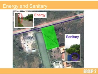
- 20. Energy and Sanitary
- 21. ÓĖüÓĖ▓ÓĖŻÓ╣ĆÓĖøÓĖźÓĖĄÓ╣łÓĖóÓĖÖÓ╣üÓĖøÓĖźÓĖćÓĖéÓĖŁÓĖćÓĖŖÓĖĖÓĖĪÓĖŖÓĖÖÓ╣āÓĖÖÓĖŁÓĖÖÓĖ▓ÓĖäÓĖĢ ÓĖłÓĖ▓ÓĖüÓĖäÓĖ¦ÓĖ▓ÓĖĪÓ╣ĆÓĖøÓ╣ćÓĖÖÓ╣äÓĖøÓ╣äÓĖöÓ╣ēÓ╣āÓĖÖÓĖŁÓĖÖÓĖ▓ÓĖäÓĖĢ ÓĖłÓĖ▓ÓĖüÓĖŻÓĖ╣ÓĖøÓĖŖÓĖĖÓĖĪÓĖŖÓĖÖÓ╣ĆÓĖŻÓĖ┤Ó╣łÓĖĪÓĖĪÓĖĄÓĖüÓĖ▓ÓĖŻÓĖéÓĖóÓĖ▓ÓĖóÓĖĢÓĖ▒ÓĖ¦ ÓĖéÓĖČÓ╣ēÓĖÖÓ╣ĆÓĖŻÓĖĘÓ╣łÓĖŁÓĖóÓ╣åÓ╣äÓĖĪÓ╣łÓĖÖÓĖ▓ÓĖÖÓĖŖÓĖĖÓĖĪÓĖŖÓĖÖÓ╣ĆÓĖ½ÓĖźÓ╣łÓĖ▓ÓĖÖÓĖ▒Ó╣ēÓĖÖÓĖüÓ╣ćÓĖłÓĖ░ÓĖéÓĖóÓĖ▓ÓĖóÓĖĪÓĖ▓ÓĖ¢ÓĖČÓĖć SITE ÓĖŚÓĖĄÓ╣łÓĖĢÓĖ▒Ó╣ēÓĖćÓĖéÓĖŁÓĖćÓĖÜÓ╣ēÓĖ▓ÓĖÖ ÓĖŁÓĖ▓ÓĖłÓĖüÓ╣łÓĖŁÓ╣āÓĖ½Ó╣ēÓ╣ĆÓĖüÓĖ┤ÓĖöÓĖøÓĖ▒ÓĖŹÓĖ½ÓĖ▓ÓĖöÓĖ▒ÓĖćÓĖÖÓĖĄÓ╣ē 1. ÓĖäÓĖ¦ÓĖ▓ÓĖĪÓĖ½ÓĖÖÓĖ▓ÓĖÖÓ╣üÓĖÖÓ╣łÓĖÖÓĖéÓĖŁÓĖćÓĖøÓĖŻÓĖ░ÓĖŖÓĖ▓ÓĖüÓĖŻ 2. ÓĖäÓĖ¦ÓĖ▓ÓĖĪÓ╣ĆÓĖøÓ╣ćÓĖÖÓĖ¬Ó╣łÓĖ¦ÓĖÖÓĖĢÓĖ▒ÓĖ¦ ÓĖłÓĖ▓ÓĖüÓĖüÓĖ▓ÓĖŻÓĖŚÓĖĄÓ╣łÓĖĪÓĖĄÓĖüÓĖ▓ÓĖŻÓĖéÓĖóÓĖ▓ÓĖóÓĖĢÓĖ▒ÓĖ¦Ó╣ĆÓĖéÓ╣ēÓĖ▓ÓĖĪÓĖ▓Ó╣ĆÓĖüÓĖ┤ÓĖöÓ╣ĆÓĖøÓ╣ćÓĖÖÓĖŖÓĖĖÓĖĪÓĖŖÓĖÖÓ╣āÓĖ½ÓĖĪÓ╣łÓ╣å ÓĖŚÓĖ│Ó╣āÓĖ½Ó╣ēÓĖ£ÓĖ╣Ó╣ēÓĖŁÓĖóÓĖ╣Ó╣łÓĖŁÓĖ▓ÓĖ©ÓĖ▒ÓĖó ÓĖĪÓĖĄÓĖäÓĖ¦ÓĖ▓ÓĖĪÓ╣ĆÓĖøÓ╣ćÓĖÖÓĖ¬Ó╣łÓĖ¦ÓĖÖÓĖĢÓĖ▒ÓĖ¦ÓĖÖÓ╣ēÓĖŁÓĖóÓĖźÓĖć 3. Ó╣ĆÓĖ¬ÓĖĄÓĖóÓĖć Ó╣ĆÓĖĪÓĖĘÓ╣łÓĖŁÓĖĪÓĖĄÓĖüÓĖ▓ÓĖŻÓĖéÓĖóÓĖ▓ÓĖóÓĖĢÓĖ▒ÓĖ¦ÓĖéÓĖŁÓĖćÓĖŖÓĖĖÓĖĪÓĖŖÓĖÖ ÓĖŚÓĖ│Ó╣āÓĖ½Ó╣ēÓĖüÓĖ▓ÓĖŻÓĖäÓĖĪÓĖÖÓĖ▓ÓĖäÓĖĪÓĖóÓĖ┤Ó╣łÓĖćÓĖĪÓĖĄÓĖÜÓĖŚÓĖÜÓĖ▓ÓĖŚÓĖĪÓĖ▓ÓĖüÓĖéÓĖČÓ╣ēÓĖÖ Ó╣āÓĖÖÓĖÜÓĖŻÓĖ┤Ó╣ĆÓĖ¦ÓĖōÓĖÖÓĖ▒Ó╣ēÓĖÖ ÓĖŁÓĖ▓ÓĖłÓĖüÓ╣łÓĖŁÓ╣āÓĖ½Ó╣ēÓ╣ĆÓĖüÓĖ┤ÓĖöÓ╣ĆÓĖ¬ÓĖĄÓĖóÓĖćÓĖŚÓĖĄÓ╣łÓĖłÓĖ░ÓĖĪÓĖ▓ÓĖŻÓĖÜÓĖüÓĖ¦ÓĖÖÓĖ£ÓĖ╣Ó╣ēÓĖŁÓĖóÓĖ╣Ó╣łÓĖŁÓĖ▓ÓĖ©ÓĖ▒ÓĖó
- 22. ÓĖüÓĖ▓ÓĖŻÓ╣ĆÓĖøÓĖźÓĖĄÓ╣łÓĖóÓĖÖÓ╣üÓĖøÓĖźÓĖćÓĖéÓĖŁÓĖćÓĖŖÓĖĖÓĖĪÓĖŖÓĖÖÓ╣āÓĖÖÓĖŁÓĖÖÓĖ▓ÓĖäÓĖĢ ÓĖÖÓĖĄÓ╣łÓĖäÓĖĘÓĖŁÓĖĀÓĖ▓ÓĖ×ÓĖéÓĖŁÓĖćÓĖäÓĖ¦ÓĖ▓ÓĖĪÓ╣ĆÓĖøÓ╣ćÓĖÖÓ╣äÓĖøÓ╣äÓĖöÓ╣ēÓĖŚÓĖĄÓ╣łÓĖłÓĖ░Ó╣ĆÓĖüÓĖ┤ÓĖöÓĖüÓĖ▓ÓĖŻÓĖüÓ╣łÓĖŁÓĖ¬ÓĖŻÓ╣ēÓĖ▓ÓĖćÓĖĀÓĖ▓ÓĖóÓ╣āÓĖÖÓĖŁÓĖÖÓĖ▓ÓĖäÓĖĢ ÓĖŚÓĖĄÓ╣łÓĖĢÓĖ▒Ó╣ēÓĖćÓĖéÓĖŁÓĖć SITE ÓĖćÓĖ▓ÓĖÖ ÓĖ×ÓĖĘÓ╣ēÓĖÖÓĖŚÓĖĄÓ╣łÓĖĪÓĖĄÓ╣üÓĖÖÓĖ¦Ó╣éÓĖÖÓ╣ēÓĖĪÓĖłÓĖ░Ó╣ĆÓĖüÓĖ┤ÓĖöÓ╣ĆÓĖøÓ╣ćÓĖÖÓĖŖÓĖĖÓĖĪÓĖŖÓĖÖÓ╣āÓĖÖÓĖŁÓĖÖÓĖ▓ÓĖäÓĖĢ
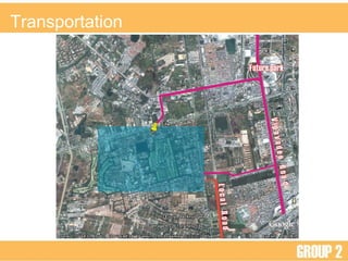
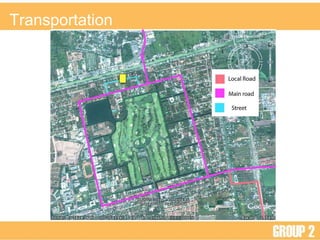
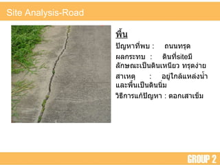
- 23. Site Analysis-Road ÓĖ×ÓĖĘÓ╣ēÓĖÖ ÓĖøÓĖ▒ÓĖŹÓĖ½ÓĖ▓ÓĖŚÓĖĄÓ╣łÓĖ×ÓĖÜ : ÓĖ¢ÓĖÖÓĖÖÓĖŚÓĖŻÓĖĖÓĖö ÓĖ£ÓĖźÓĖüÓĖŻÓĖ░ÓĖŚÓĖÜ : ÓĖöÓĖ┤ÓĖÖÓĖŚÓĖĄÓ╣ł site ÓĖĪÓĖĄÓĖźÓĖ▒ÓĖüÓĖ®ÓĖōÓĖ░Ó╣ĆÓĖøÓ╣ćÓĖÖÓĖöÓĖ┤ÓĖÖÓ╣ĆÓĖ½ÓĖÖÓĖĄÓĖóÓĖ¦ ÓĖŚÓĖŻÓĖĖÓĖöÓĖćÓ╣łÓĖ▓ÓĖó ÓĖ¬ÓĖ▓Ó╣ĆÓĖ½ÓĖĢÓĖĖ : ÓĖŁÓĖóÓĖ╣Ó╣łÓ╣āÓĖüÓĖźÓ╣ēÓ╣üÓĖ½ÓĖźÓ╣łÓĖćÓĖÖÓ╣ēÓĖ│Ó╣üÓĖźÓĖ░ÓĖ×ÓĖĘÓ╣ēÓĖÖÓ╣ĆÓĖøÓ╣ćÓĖÖÓĖöÓĖ┤ÓĖÖÓĖÖÓĖ┤Ó╣łÓĖĪ ÓĖ¦ÓĖ┤ÓĖśÓĖĄÓĖüÓĖ▓ÓĖŻÓ╣üÓĖüÓ╣ēÓĖøÓĖ▒ÓĖŹÓĖ½ÓĖ▓ : ÓĖĢÓĖŁÓĖüÓ╣ĆÓĖ¬ÓĖ▓Ó╣ĆÓĖéÓ╣ćÓĖĪ