際際滷

際際滷Share a Scribd company logo
Dutch East Indiesto the
A Journey
I
magine boarding a sailing ship of
the Dutch East India Company in the
1700s and heading through the English
Channel bound for the Indies. Your ship is the
Diemermeer, a heavily armed cargo vessel that
the Vereenigde Oost-Indische Compagnie (VOC)
built at its shipyards in Amsterdam. At about
40 metres in length, the Diemermeer is laden
with textiles, wine, stone ballast, cannon,
domestic goods and many chests of silver and
gold coins, for trade with the principalities and
kingdoms of the East. The whole cargo would
be worth several million euros in modern
money. The ship has already made several
voyages to the Indies, though the skipper is
a first timer. Your survival, and that of your
fellow crew members and passengers, depends
on the skill of the skipper and navigator,
aided by a few navigational devices and some
paper and calfskin (vellum) sea charts. If the
destination is reached in the prescribed five to
eight months (shipwrecks are not uncommon
and mortality from disease is high), the charts
will be returned to their pewter canisters and
later used on the return voyage. If not and
some mishap were to befall the Diemermeer,
the VOC would investigate the disaster, one
of over 300 losses recorded by the company
over its lifetime (16021800). As it happened,
and it is graphically described on one of these
charts, the Diemermeer was very nearly another
such statistic.
Though there are many printed reproductions
of Dutch maps, little remains of the working
charts used on board to guide the ships. Hand-
drawn charts referred to by the skippers of
VOC ships, especially those from sea voyages to
the East Indies and Australia, are extremely rare
and valuable. None is to be found in Australian
museums or librariesthe four navigation
charts, which Kerry Stokes AO has loaned to
the Library, are unique artefacts of this era of
exploration. Drawn on vellum in the 1730s
and still in perfect condition, the charts came to
light in the 1980s, through the publisher Nico
Israel of Amsterdam.
The four vellum navigational charts were
issued with other equipment to ships captains
Martin Woods explains the
importance of rare early
documents, on loan to the
Library, relating to the
exploration of the Dutch
East Indies and Australia
below left
Johan de Baen
Six of the Gentlemen
Governors of the Hoorn
Chamber 1682
oil; 123.0 x 140.0 cm
Courtesy Westfries Museum,
Hoorn, the Netherlands
below right
Gregory van Raalte
A replica of the seventeenth-
century sailing ship
Amsterdam in Amsterdam
harbour
Photo: iStockphoto #1573566
24::
bound for the East Indies. Three of the charts
were drawn in 1735 in Amsterdam by Isaac de
Graaf (16671743), the official cartographer
of the VOC, and were used for voyages to
the East Indies, and one of these has been
associated with a known voyage, thanks to
remarkably clear remnant pencil tracks of
the voyage drawn by the skipper, losing his
bearings on several occasions as he struggled
to keep the ship on course in a storm. One of
the three is a detailed chart of the Netherlands
ports, and the other two are of the Indian
Ocean (including western and northern
Australia). The fourth chart is of the Dutch
bases in Java and Borneo and was drawn about
the same time in the cartographic workshops
of Batavia (now Jakarta), the centre of Dutch
trade and exploration in the East. Together,
the charts are an excellent set of discovery
documents for Australia and the region.
They depict the VOC experience from home
country to colony, showing how difficult it was
in the period before chronometers to accurately
determine position.
In the seventeenth and eighteenth centuries,
the VOC was the largest trading and shipping
enterprise in the world, operating in countries
from the Netherlands to China and Japan. The
history of the first multinational began at
the end of the sixteenth century when Dutch
merchants were excluded from the lucrative
trade in spices. The response by the leaders in
the seven Dutch provinces that were not under
the sway of Spain was to break the Portuguese
monopoly and establish a joint venture of their
own: so in 1602 they
formed the VOC, which
received a monopoly
on all Dutch trade and
shipping.
Although a business,
the company operated as
an arm of government.
In the name of the
Dutch Estates-General
(the Dutch parliament),
the VOC could wage
war on other nations,
enter into treaties with
foreign monarchs, build
forts and trading posts,
appoint administrators
and enlist soldiers.
Thus, the interests of
the VOC were not only
those of merchants and
craftsmen and their families, but also of the
Dutch nation, which in the mid-1700s was
the wealthiest and most urbanised region of
Europe. Through Amsterdam, the Dutch
dominated world trade, securing a vast colonial
empire and operating the largest fleet of
merchantmen of all Western nations.
Knowledge is power, and the informational
hub of VOC revolved around a single
individual, the chief cartographer, who
controlled the companys strategic mapping.
From 1705 until his death in 1743, the
position was held by Isaac de Graaf. The
charts were drawn at the height of his
left
Unknown cartographer
Chart of the Java Sea c.1700
(detail)
Loan courtesy Mr Kerry Stokes AO
below
Homann Erben
Der Hollaendisch-
Ostindianischen Compagnie
weltberuhmte Haupt-
Handels und Niederlags-Stadt
Batavia油 1762
coloured map; 45.8 x 54.1 cm
Maps Collection
nla.map-rm270
the national library magazine :: september 2009 :: 25
powers, with navigational refinements based
on 30 years of voyage accounts and charts.
By the time de Graaf assumed the mantle
of chief cartographer, VOC navigators had
mapped most of the eastern hemisphere,
including parts of New Holland (Australia).
De Graaf and his team of mapmakers in
Amsterdam supplied the outward bound
ships with navigational charts, supplemented
with the knowledge supplied by returning
skippers. They would draw reference charts
of all countries, islands, coasts and other
areas, providing important knowledge of the
ports, towns, islands and hazards essential
for a safe journey. The cartographers were
sworn to secrecy and forbidden to disclose
any information regarding their activities
to third parties. The charts, containing the
entire geographical knowledge base of the
VOC, were returned to East India House
in Amsterdam for safe-keeping. There most
remained until the disbanding of the
VOC in 1800.
In the 1730s, there were over 160 VOC
ships in regular use, with nearly 400 voyages
to Asia completed each year. The volume and
value of freight was immense. Indian textiles,
tea and tin in China, copper from Japan, gold
from Persia and much more made its way
through Asia and between Asia and Europe.
The focus to Australias near north was on
the myriad Indonesian islands, where the
most valuable of all cargoes, spices, seemed
ever abundantcloves from the Ambonese
islands, mace and nutmeg from Banda and
pepper from the gardens of Jambi, Palembang,
Bantam and Malabar. It was virtually
impossible to move an Indonesian clove
without the VOCs permission.
Voyages to the East Indies generally started
from Amsterdams Port Texel and progressed
through the English Channel to Madeira.
One of the three de Graaf charts on loan to
the Library was the official Dutch East Indies
Company navigation chart of the North
Sea and the Netherlands, providing detailed
coastal charting of the Netherlands and
England. Exiting the Channel, ships made
for Tenerife, off the Moroccan coast, then
past the Cape Verde Islands, south-easterly
across the equator, eventually arriving at the
Cape of Good Hope. Here the small-scale
Indian Ocean charts would be taken from
their pewter canister. These maps of the open
sea indicate the key navigational points to be
referenced until the Sunda Strait (between
Java and Sumatra) was reached, with careful
warnings to avoid the west Australian coast.
One of the two Indian Ocean charts is
clean, as if unused. The other was drawn and
signed by de Graaf in 1735 and was used in
1745 and 1746 on the Diemermeer, skippered
by Christiaan Boord, when it sailed for the
Malabar Coast and Ceylon (now Sri Lanka),
before reloading and continuing to Batavia.
This chart bears De Graafs inked instructions,
which are clear in their intent: proceed to the
south of the Cape of Good Hope until the
trade winds are encountered, sail east to the
islands of St Paul and Amsterdam (roughly
equidistant from Africa, India and Australia),
sail north-east towards the Sunda Strait or, in
this case, north to Ceylon first. However, as
many had found previously, adhering to these
instructions was easier said than done. The
ships progress during the two journeys is told
through the pencil tracks faithfully recorded
by Boord and includes the most hazardous
part of the journey, from the Cape across the
Indian Ocean.
It can be seen from the chart that this
skipper, like others before him, took great care
to record his progress, including observations
on the weather, the dates and daily position
of the ship. What emerges clearly in these
on-board recordings are clues to the difficulties
the Dutch faced in estimating longitude.
above
Isaac de Graaf (16671743)
From the Netherlands to the
English Channel (detail)
Loan courtesy Mr Kerry Stokes AO
26::
The chief problem facing Boord on the
leg from the Cape to Amsterdam and St
Paul Islands, in the middle of the southern
Indian Ocean and traditionally the northward
turning point, was not the weather but lack
of knowledge. Although latitude could be
calculated quite accurately, the measurement
of distances eastwest was an inexact science
and was one of the reasons why Dutch ships
occasionally ran aground on the reefs and
shoals of Australias west coast.
In the eighteenth century, East Indiamen
sailed virtually all year round, such was the
volume of cargo. The Diemermeer was one of
several that departed the Cape in February
1745. Having made good time with the
prevailing winds, it is clear from this chart
that Boord, on his first voyage as skipper to
the Indies, fell well short of these tiny islands.
This was always a challenge for a first-time
skipper, who could not rely on past observation
of prevailing winds and currents. The chart
tracks reveal that the ship then spent several
days circling to the east before finally arriving
at Amsterdam Island on 10 April. The delay
was compounded as the ship turned north and
caught a southerly storm . The chart shows
that the ship, identified as the Diemermeer
from the dates on the chart, encountered the
storm in the mid-Indian Ocean, causing it
to turn and run, resulting in a further, more
significant delay.
The tracks show that, having paused on
Amsterdam Island for a day or so to search
for food and water, Boord made fair progress
northward, but at about 29 degrees south
the Diemermeer apparently encountered
the last of the strong winds that blow
south of the equator from October until
April. For nearly a week, the ship sped
southward. The abating winds finally
allowed Boord a gradual tack to the
north-east, before resuming the northerly
route to Ceylon. He must have been
greatly relieved when the winds died
down; the skippers punishment for loss
of ship or cargo, presuming he survived,
would be dismissal and prosecution.
In all, Boord had lost nearly a month.
When he eventually arrived at the
Malabar coast, where there was a Dutch
base at Cape Cormorin (Tamil Nadu),
the longitude he recorded placed Boord
far to the west of his actual position.
There is no record of the ships voyage
other than this chart, but it may be
assumed that any delay was costly, both in
terms of the health of the crew and trading
arrangements at port.
A second sequence of daily positions from
Ceylon, starting the following May, is also
present on the chart. We do not know if
Boord was the skipper, but the same hand is
evident on the chart. It took the Diemermeer,
now presumably laden with textiles from
Coromandel and pepper from Ceylon, past
Sumatra and through the Sunda Strait safely
to Bantam, about 80 kilometres west of the
administrative capital of Batavia on Java, and
where its cargo was traded on, before returning
to the Dutch Republic with spices.
According to printed information, we
know that the Diemermeer was wrecked on
its homeward voyage off New Guinea. The
chart was most likely handed in at Batavia,
where there was a cartographic workshop. The
survival of Boords tracks remains as mysterious
as the man, for whom there is no record after
the loss of the Diemermeer. It was customary
to transfer the skippers track information at
Batavia onto paper charts, while the vellum
chart was cleaned for re-use. The survival of
these tracks, such a rare occurrence, helps us
gain insight into the difficulties of navigation,
and the early charting of our region.
DR MARTIN WOODS is President of the
Australian and New Zealand Map Society, and
Curator of Maps at the National Library
below
Isaac de Graaf (16671743)
From the Cape to Sunda Straits
c.1735 (detail)
Loan courtesy Mr Kerry Stokes AO
the national library magazine :: september 2009 :: 27
Ad

Recommended

Columbus Had A Map
Columbus Had A Map
Graeme Boyce
Portuguese Explorers
cjreed
Chinese Lesson 2
Chinese Lesson 2
thejamiesherman
DANUM MAPHARFIL REPORT
Randy Nobleza
Gema Intermulia Sejahtera - Jakarta Office Market in 2015
Jakarta Business Networkers
Ifrastructure Asia - presented by Alex Hawkes
Jakarta Business Networkers
Cats with pretty eyes
erica-tang
C担ng ty v畛 sinh m担i tr動畛ng 担 thi h n畛i2
toantam777
One asia group - JBN - September 2014
Jakarta Business Networkers
New new media
New new media
Randy Nobleza
Trasplante de 坦rganos
aslaneto
Practicas html (1)
blascott
Hong Kong Trade - Jakarta Business Networkers
Jakarta Business Networkers
Smart Law - Understanding Business Contracts
Jakarta Business Networkers
p4 statistic no.0001709
jmhia
Cfs background
Cfs background
Randy Nobleza
Ism x msc for pathos
Randy Nobleza
Sari husada presentation
Jakarta Business Networkers
Nonja peters aapi ccat lecture may 2014
suesummers
Dutch East India Company.ppt
ssuserca85f7
Scanning_Dutch_Asian_Maritime_Heritage
Nico Vriend
Dutch
Dutch
000175031
Voc (dutch east india company)
000175031
Global Sailing: Ships, Pilots and Cosmographers
留溜了侶 留粒粒竜了溜隆侶
Dutch east india company....
Ian Pascual
English east india company
Ian Pascual
Shanti Travel Sustainability Report - 2022-2023 (2).pdf
stephane265758
Delhi to Patiala Cab | Delhi to Patiala Taxi
Cab Bazar
Preparation for Langtang Valley Trek.docx
Haven Holidays Pvt. Ltd.
Flights to Hyderabad: Where History Meets Modern India
Travelopod

More Related Content

Viewers also liked (10)

One asia group - JBN - September 2014
Jakarta Business Networkers
New new media
New new media
Randy Nobleza
Trasplante de 坦rganos
aslaneto
Practicas html (1)
blascott
Hong Kong Trade - Jakarta Business Networkers
Jakarta Business Networkers
Smart Law - Understanding Business Contracts
Jakarta Business Networkers
p4 statistic no.0001709
jmhia
Cfs background
Cfs background
Randy Nobleza
Ism x msc for pathos
Randy Nobleza
Sari husada presentation
Jakarta Business Networkers
Trasplante de 坦rganos
aslaneto
Practicas html (1)
blascott
Hong Kong Trade - Jakarta Business Networkers
Jakarta Business Networkers
p4 statistic no.0001709
jmhia
Ism x msc for pathos
Randy Nobleza

Similar to A journey to the dutch east indies (8)

Nonja peters aapi ccat lecture may 2014
suesummers
Dutch East India Company.ppt
ssuserca85f7
Scanning_Dutch_Asian_Maritime_Heritage
Nico Vriend
Dutch
Dutch
000175031
Voc (dutch east india company)
000175031
Global Sailing: Ships, Pilots and Cosmographers
留溜了侶 留粒粒竜了溜隆侶
Dutch east india company....
Ian Pascual
English east india company
Ian Pascual
Nonja peters aapi ccat lecture may 2014
suesummers
Dutch East India Company.ppt
ssuserca85f7
Scanning_Dutch_Asian_Maritime_Heritage
Nico Vriend
Voc (dutch east india company)
000175031
Dutch east india company....
Ian Pascual
English east india company
Ian Pascual
Ad

Recently uploaded (20)

Shanti Travel Sustainability Report - 2022-2023 (2).pdf
stephane265758
Delhi to Patiala Cab | Delhi to Patiala Taxi
Cab Bazar
Preparation for Langtang Valley Trek.docx
Haven Holidays Pvt. Ltd.
Flights to Hyderabad: Where History Meets Modern India
Travelopod
Corporate Visa Sponsorship Letter Format Guide with Sample 2025
ajitmanewgblindia
Delhi to Haldwani Cab | Delhi to Haldwani Taxi
Cab Bazar
The Best Day Trips from Washington DC - Article
Etiquette Cruises
Top Student Group Tour Packages Trusted & Safe
Tafri Travel
Travel with Karthik - Tourism Places in Kadapa
Gowtham Karthik
Corporate Visa Support for Global Events 2025 Complete Assistance Guide
ajitmanewgblindia
Indian IT Sector Drives Surge in Schengen Business Visas 2025 Insights
ajitmanewgblindia
Delhi to Katra Cab | Delhi to Katra Taxi
Cab Bazar
PACAYA SAMIRIA NATIONAL RESERVE PERU WORLD
DeanT800
Delhi to Mussoorie Cab | Delhi to Mussoorie Taxi
Cab Bazar
Eric Albuja Share Top 5 Benefits of Contactless Travel Tech.pdf
Eric Albuja
A-Z Travel Guide To Witness Perfume Pagoda In Hanoi
threelandt25
Budget-Friendly Travel Tips for Seeing the World by Chris Janese
Chris Janese
Corporate Gift Vouchers for Employees: A Modern Approach to Workplace Rewards
Dreamedays.ae
Akshat Sethi Pilot Leadership and Excellence in Indian Aviation
Akshat Sethi
How to Track Your Train's Location with Live Train Status
RailRestro: Order Food in Train
Ad

A journey to the dutch east indies

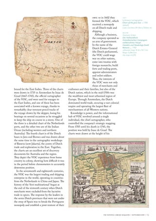
  • 1. Dutch East Indiesto the A Journey I magine boarding a sailing ship of the Dutch East India Company in the 1700s and heading through the English Channel bound for the Indies. Your ship is the Diemermeer, a heavily armed cargo vessel that the Vereenigde Oost-Indische Compagnie (VOC) built at its shipyards in Amsterdam. At about 40 metres in length, the Diemermeer is laden with textiles, wine, stone ballast, cannon, domestic goods and many chests of silver and gold coins, for trade with the principalities and kingdoms of the East. The whole cargo would be worth several million euros in modern money. The ship has already made several voyages to the Indies, though the skipper is a first timer. Your survival, and that of your fellow crew members and passengers, depends on the skill of the skipper and navigator, aided by a few navigational devices and some paper and calfskin (vellum) sea charts. If the destination is reached in the prescribed five to eight months (shipwrecks are not uncommon and mortality from disease is high), the charts will be returned to their pewter canisters and later used on the return voyage. If not and some mishap were to befall the Diemermeer, the VOC would investigate the disaster, one of over 300 losses recorded by the company over its lifetime (16021800). As it happened, and it is graphically described on one of these charts, the Diemermeer was very nearly another such statistic. Though there are many printed reproductions of Dutch maps, little remains of the working charts used on board to guide the ships. Hand- drawn charts referred to by the skippers of VOC ships, especially those from sea voyages to the East Indies and Australia, are extremely rare and valuable. None is to be found in Australian museums or librariesthe four navigation charts, which Kerry Stokes AO has loaned to the Library, are unique artefacts of this era of exploration. Drawn on vellum in the 1730s and still in perfect condition, the charts came to light in the 1980s, through the publisher Nico Israel of Amsterdam. The four vellum navigational charts were issued with other equipment to ships captains Martin Woods explains the importance of rare early documents, on loan to the Library, relating to the exploration of the Dutch East Indies and Australia below left Johan de Baen Six of the Gentlemen Governors of the Hoorn Chamber 1682 oil; 123.0 x 140.0 cm Courtesy Westfries Museum, Hoorn, the Netherlands below right Gregory van Raalte A replica of the seventeenth- century sailing ship Amsterdam in Amsterdam harbour Photo: iStockphoto #1573566 24::
  • 2. bound for the East Indies. Three of the charts were drawn in 1735 in Amsterdam by Isaac de Graaf (16671743), the official cartographer of the VOC, and were used for voyages to the East Indies, and one of these has been associated with a known voyage, thanks to remarkably clear remnant pencil tracks of the voyage drawn by the skipper, losing his bearings on several occasions as he struggled to keep the ship on course in a storm. One of the three is a detailed chart of the Netherlands ports, and the other two are of the Indian Ocean (including western and northern Australia). The fourth chart is of the Dutch bases in Java and Borneo and was drawn about the same time in the cartographic workshops of Batavia (now Jakarta), the centre of Dutch trade and exploration in the East. Together, the charts are an excellent set of discovery documents for Australia and the region. They depict the VOC experience from home country to colony, showing how difficult it was in the period before chronometers to accurately determine position. In the seventeenth and eighteenth centuries, the VOC was the largest trading and shipping enterprise in the world, operating in countries from the Netherlands to China and Japan. The history of the first multinational began at the end of the sixteenth century when Dutch merchants were excluded from the lucrative trade in spices. The response by the leaders in the seven Dutch provinces that were not under the sway of Spain was to break the Portuguese monopoly and establish a joint venture of their own: so in 1602 they formed the VOC, which received a monopoly on all Dutch trade and shipping. Although a business, the company operated as an arm of government. In the name of the Dutch Estates-General (the Dutch parliament), the VOC could wage war on other nations, enter into treaties with foreign monarchs, build forts and trading posts, appoint administrators and enlist soldiers. Thus, the interests of the VOC were not only those of merchants and craftsmen and their families, but also of the Dutch nation, which in the mid-1700s was the wealthiest and most urbanised region of Europe. Through Amsterdam, the Dutch dominated world trade, securing a vast colonial empire and operating the largest fleet of merchantmen of all Western nations. Knowledge is power, and the informational hub of VOC revolved around a single individual, the chief cartographer, who controlled the companys strategic mapping. From 1705 until his death in 1743, the position was held by Isaac de Graaf. The charts were drawn at the height of his left Unknown cartographer Chart of the Java Sea c.1700 (detail) Loan courtesy Mr Kerry Stokes AO below Homann Erben Der Hollaendisch- Ostindianischen Compagnie weltberuhmte Haupt- Handels und Niederlags-Stadt Batavia油 1762 coloured map; 45.8 x 54.1 cm Maps Collection nla.map-rm270 the national library magazine :: september 2009 :: 25
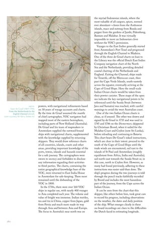
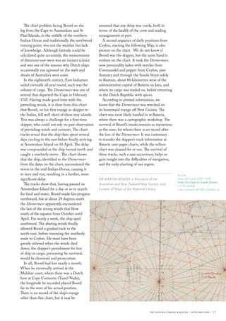
  • 3. powers, with navigational refinements based on 30 years of voyage accounts and charts. By the time de Graaf assumed the mantle of chief cartographer, VOC navigators had mapped most of the eastern hemisphere, including parts of New Holland (Australia). De Graaf and his team of mapmakers in Amsterdam supplied the outward bound ships with navigational charts, supplemented with the knowledge supplied by returning skippers. They would draw reference charts of all countries, islands, coasts and other areas, providing important knowledge of the ports, towns, islands and hazards essential for a safe journey. The cartographers were sworn to secrecy and forbidden to disclose any information regarding their activities to third parties. The charts, containing the entire geographical knowledge base of the VOC, were returned to East India House in Amsterdam for safe-keeping. There most remained until the disbanding of the VOC in 1800. In the 1730s, there were over 160 VOC ships in regular use, with nearly 400 voyages to Asia completed each year. The volume and value of freight was immense. Indian textiles, tea and tin in China, copper from Japan, gold from Persia and much more made its way through Asia and between Asia and Europe. The focus to Australias near north was on the myriad Indonesian islands, where the most valuable of all cargoes, spices, seemed ever abundantcloves from the Ambonese islands, mace and nutmeg from Banda and pepper from the gardens of Jambi, Palembang, Bantam and Malabar. It was virtually impossible to move an Indonesian clove without the VOCs permission. Voyages to the East Indies generally started from Amsterdams Port Texel and progressed through the English Channel to Madeira. One of the three de Graaf charts on loan to the Library was the official Dutch East Indies Company navigation chart of the North Sea and the Netherlands, providing detailed coastal charting of the Netherlands and England. Exiting the Channel, ships made for Tenerife, off the Moroccan coast, then past the Cape Verde Islands, south-easterly across the equator, eventually arriving at the Cape of Good Hope. Here the small-scale Indian Ocean charts would be taken from their pewter canister. These maps of the open sea indicate the key navigational points to be referenced until the Sunda Strait (between Java and Sumatra) was reached, with careful warnings to avoid the west Australian coast. One of the two Indian Ocean charts is clean, as if unused. The other was drawn and signed by de Graaf in 1735 and was used in 1745 and 1746 on the Diemermeer, skippered by Christiaan Boord, when it sailed for the Malabar Coast and Ceylon (now Sri Lanka), before reloading and continuing to Batavia. This chart bears De Graafs inked instructions, which are clear in their intent: proceed to the south of the Cape of Good Hope until the trade winds are encountered, sail east to the islands of St Paul and Amsterdam (roughly equidistant from Africa, India and Australia), sail north-east towards the Sunda Strait or, in this case, north to Ceylon first. However, as many had found previously, adhering to these instructions was easier said than done. The ships progress during the two journeys is told through the pencil tracks faithfully recorded by Boord and includes the most hazardous part of the journey, from the Cape across the Indian Ocean. It can be seen from the chart that this skipper, like others before him, took great care to record his progress, including observations on the weather, the dates and daily position of the ship. What emerges clearly in these on-board recordings are clues to the difficulties the Dutch faced in estimating longitude. above Isaac de Graaf (16671743) From the Netherlands to the English Channel (detail) Loan courtesy Mr Kerry Stokes AO 26::
  • 4. The chief problem facing Boord on the leg from the Cape to Amsterdam and St Paul Islands, in the middle of the southern Indian Ocean and traditionally the northward turning point, was not the weather but lack of knowledge. Although latitude could be calculated quite accurately, the measurement of distances eastwest was an inexact science and was one of the reasons why Dutch ships occasionally ran aground on the reefs and shoals of Australias west coast. In the eighteenth century, East Indiamen sailed virtually all year round, such was the volume of cargo. The Diemermeer was one of several that departed the Cape in February 1745. Having made good time with the prevailing winds, it is clear from this chart that Boord, on his first voyage as skipper to the Indies, fell well short of these tiny islands. This was always a challenge for a first-time skipper, who could not rely on past observation of prevailing winds and currents. The chart tracks reveal that the ship then spent several days circling to the east before finally arriving at Amsterdam Island on 10 April. The delay was compounded as the ship turned north and caught a southerly storm . The chart shows that the ship, identified as the Diemermeer from the dates on the chart, encountered the storm in the mid-Indian Ocean, causing it to turn and run, resulting in a further, more significant delay. The tracks show that, having paused on Amsterdam Island for a day or so to search for food and water, Boord made fair progress northward, but at about 29 degrees south the Diemermeer apparently encountered the last of the strong winds that blow south of the equator from October until April. For nearly a week, the ship sped southward. The abating winds finally allowed Boord a gradual tack to the north-east, before resuming the northerly route to Ceylon. He must have been greatly relieved when the winds died down; the skippers punishment for loss of ship or cargo, presuming he survived, would be dismissal and prosecution. In all, Boord had lost nearly a month. When he eventually arrived at the Malabar coast, where there was a Dutch base at Cape Cormorin (Tamil Nadu), the longitude he recorded placed Boord far to the west of his actual position. There is no record of the ships voyage other than this chart, but it may be assumed that any delay was costly, both in terms of the health of the crew and trading arrangements at port. A second sequence of daily positions from Ceylon, starting the following May, is also present on the chart. We do not know if Boord was the skipper, but the same hand is evident on the chart. It took the Diemermeer, now presumably laden with textiles from Coromandel and pepper from Ceylon, past Sumatra and through the Sunda Strait safely to Bantam, about 80 kilometres west of the administrative capital of Batavia on Java, and where its cargo was traded on, before returning to the Dutch Republic with spices. According to printed information, we know that the Diemermeer was wrecked on its homeward voyage off New Guinea. The chart was most likely handed in at Batavia, where there was a cartographic workshop. The survival of Boords tracks remains as mysterious as the man, for whom there is no record after the loss of the Diemermeer. It was customary to transfer the skippers track information at Batavia onto paper charts, while the vellum chart was cleaned for re-use. The survival of these tracks, such a rare occurrence, helps us gain insight into the difficulties of navigation, and the early charting of our region. DR MARTIN WOODS is President of the Australian and New Zealand Map Society, and Curator of Maps at the National Library below Isaac de Graaf (16671743) From the Cape to Sunda Straits c.1735 (detail) Loan courtesy Mr Kerry Stokes AO the national library magazine :: september 2009 :: 27