Airphoto anomilies
1 like941 views

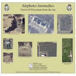
This document provides a summary of various airphoto anomalies spotted from aerial views of different locations in Wisconsin. It was prepared by the North Central Wisconsin Regional Planning Commission and thanks regional planning commissions of East Central, Bay Lake, and Dane County. The anomalies spotted include a prescribed fire burn area in Juneau County, a corn maze in the Town of Scott in Lincoln County, a funky pond design in Wood County, a field layout near an airport runway in the Town of Grand Chute in Outagamie County, farming activity in Juneau County, and a horse showing track and hop field in Dane County.
1 of 1
Download to read offline
Ad
Recommended
Final sean
Final seanseangarner
Ěý
Louisiana State University is a public university located in Baton Rouge, Louisiana. It was established in 1853 and its main building was completed in 1859. The university offers bachelor's, nursing, and doctorate degrees. Major programs include engineering, for which the curriculum spans four years and includes courses in biology, chemistry, physics, mathematics, and engineering design. Notable alumni of LSU include Shaquille O'Neal, Will Wright, and Hubert Humphrey. The document provides tuition costs for the Tiger Bridge Program and reasons for wanting to attend LSU, such as its proximity to home and the football team.Earl Prize Board
Earl Prize BoardThomas McCormick
Ěý
The Kickapoo Cabin Village in Illinois seeks to provide an immersive camping experience through six cabins nestled in the woods along a ravine and pond. The village includes a communal shelter for cooking and gathering, and a dock providing kayak access. The cabins are designed to take advantage of the natural landscape, redefining the traditional cabin village concept.Mackay's Country House Collection
Mackay's Country House CollectionMellisa Turner
Ěý
PLAN YOUR VACATION FOR SCOTLAND AND ENJOY THE LEISURE OF SCOTLAND BEAUTY AND CLIMATE BUT ALSO ENJOY A KING STYLE INDEPENDENT SCOTTISH COTTAGES.Wilson's Prom National Park
Wilson's Prom National Parkseriata
Ěý
Wilson's Prom National Park offers various camping facilities including flushed toilets, fresh drinking water, and hot showers. Recreational activities at the park include surfing, swimming, biking, and hiking. Visitors can access the park by car or bus. Fees for access and activities vary. The park features natural attractions like scenic views and birdwatching. Camping equipment like tents, sleeping bags, lanterns, and cooking supplies are required, and the weather is usually around 20°C.Weekend family holiday home
Weekend family holiday homeBirchgrove Farm
Ěý
Are you searching family holiday rental houses or vacation destination at Berry, NSW? Birchgrove farm is a destination where you can relax in the absolute peaceful environment. Birchgrove Farm is ideal for romantic getaways and family holidays. The expansive and manicured gardens provide complete privacy. Visit our site http://www.birchgrovefarm.com.au for more details.7 Thanksgiving Fun Facts
7 Thanksgiving Fun FactsEmmett Brennan
Ěý
This document presents 7 fun facts about Thanksgiving: 1) Americans eat around 500 million pounds of turkey each Thanksgiving. 2) The average person consumes 4,500 calories of food on Thanksgiving. 3) Abraham Lincoln established the original date for celebrating Thanksgiving. 4) There are 3 towns and 9 townships in the US named after turkey. 5) Parts of a turkey that are not edible include the gobble and wattle. 6) Turkeys can have heart attacks and drown if they look up during rain. 7) Items missing from the original Thanksgiving feast included pumpkin pie, milk, bread, and butter.Location scouting sheet
Location scouting sheetmcdoh
Ěý
The document contains location scouting sheets for three potential filming locations for a music video: Fairlop waters park, a private house in Buckhurst Hill, and Buckhurst Hill park. Fairlop waters is available on Mondays mornings and has a power socket. The private house is available on Fridays evenings and has a power socket. Buckhurst Hill park is available on Fridays evenings but does not have power capabilities.Locationscoutingsheet
Locationscoutingsheetbentheman21
Ěý
The document contains location scouting sheets for three potential filming locations for a music video: Fairlop waters park which is available on Mondays mornings and has a power socket, a private house in Buckhurst Hill available on Fridays evenings with a power socket, and Buckhurst Hill park available on Fridays evenings without power capabilities.A wikimap of landscape values in the bad river watershed carl sack
A wikimap of landscape values in the bad river watershed carl sackWisconsin Land Information Association
Ěý
This document summarizes a wikimapping project in the Bad River Watershed that allowed local residents to share their landscape values online. The project was designed with user-centered and stakeholder input to empower local voices in land use decisions. A web-based wikimap was created for residents to identify important landscape features. Workshops were held to demonstrate the map and get public feedback. The project was evaluated based on how users engaged with the mapping system and whether it impacted perceptions of landscape values in the community. Funding was provided by the Cartography Specialty Group with special thanks to Dr. Robert E. Roth.Workshop using open source software for mobile data collection workshop - a...
Workshop using open source software for mobile data collection workshop - a...Wisconsin Land Information Association
Ěý
Open Data Kit (ODK) is an open-source suite of tools that allows for mobile data collection and submission to an online server. It includes ODK Collect for mobile data entry, ODK Aggregate as a backend server for storage and analysis, and tools for building custom forms like ODK Build. The presentation provides an overview of installing and using the ODK system, including deploying Aggregate on Google App Engine or a local server, designing forms, collecting and analyzing data, and exporting it to formats like CSV, KML, and publishing to Google Fusion Tables. Examples are given of displaying collected data on maps and with charts through the ODK Aggregate interface.Wigicc's role in wisconsin jon schwitchtenberg
Wigicc's role in wisconsin jon schwitchtenbergWisconsin Land Information Association
Ěý
The Wisconsin Geographic Information Coordination Council (WIGICC) was created to coordinate geographic information statewide. It is comprised of 19 voting members from state and local government, tribal, private, non-profit, and education sectors. WIGICC works to improve access, utility, and value of geographic data through leadership, collaboration, data sharing, and advising decision-makers. Recent accomplishments include supporting statewide initiatives and representing geospatial interests to legislators.
Surveying and land records management dean roth
Surveying and land records management dean rothWisconsin Land Information Association
Ěý
This document discusses the land records review process in one county to identify common mistakes. It describes how the county assistant surveyor reviews Certified Survey Maps (CSMs), subdivision plats, and condominium plats submitted for recording, though not plats of survey. The review aims to ensure compliance with regulations and address issues like accurate parcel boundaries, public safety, and environmental concerns before updating tax and land records. The surveyor drafts parcel boundaries in CAD software and checks for errors in distances, areas, and legal descriptions compared to the submitted survey. Comments are provided to the applicant and other county departments for revision before recording.Mapping spatial patterns of whai finder usage to measure community outreach e...
Mapping spatial patterns of whai finder usage to measure community outreach e...Wisconsin Land Information Association
Ěý
This document summarizes research analyzing spatial patterns of usage of the WHAIFinder mapping tool to measure the effectiveness of community outreach. Usage data from over 16,000 visits by nearly 10,000 unique visitors over one year was collected and analyzed. Results found relatively uniform usage across Wisconsin with some underserved areas. A statistical model found a moderate relationship between visitor numbers and county population, and a stronger relationship with broadband access, though some variance remained unexplained. The research provides a quantitative method to evaluate information delivery and identify opportunities to improve outreach goals.Local gis in the statewide voter registration system sarah whitt
Local gis in the statewide voter registration system sarah whittWisconsin Land Information Association
Ěý
This document discusses mapping tools in the SVRS system, the benefits and problems of mapping, and provides contact information for Zachary Robinson and Sarah Whitt at the Wisconsin government who can provide assistance with mapping in SVRS. It also thanks county and municipal GIS partners for their data assistance throughout the year.Li dar quality control a client's perspective - tyler grosshuesch
Li dar quality control a client's perspective - tyler grosshueschWisconsin Land Information Association
Ěý
Li dar meets wisconsinview jc nelson
Li dar meets wisconsinview jc nelsonWisconsin Land Information Association
Ěý
The document discusses a collaboration between various Wisconsin organizations to coordinate LiDAR data access through hosting the data on WisconsinView. It notes the need for a centralized location for LiDAR data in Wisconsin. Through collaboration between Wisconsin organizations including WIGICC, WI DNR, WisconsinView, and others, LiDAR data collected by counties will be hosted on WisconsinView for public access. The objective is for WisconsinView to serve as a single location to access Wisconsin LiDAR data, starting with derived products and working towards hosting all collected LiDAR data.Lakesheds and riverscapes extending wisconsin's hydro database with landsca...
Lakesheds and riverscapes extending wisconsin's hydro database with landsca...Wisconsin Land Information Association
Ěý
The document summarizes efforts by the Wisconsin DNR to extend Wisconsin's hydrologic database with landscape attributes. Key points include:
- The DNR delineated HUC16 watersheds and 24K riparian zones for Wisconsin streams and lakes, assigning over 997 attributes to each.
- A neural network model was developed to estimate historic and future daily stream temperatures using watershed characteristics and weather data.
- The enhanced hydrologic database allows modeling of fish communities, nutrient loading, and how stream biology may be impacted by climate change.Lake habitat mapping with side scan sonar in nine wisconsin lakes - christine...
Lake habitat mapping with side scan sonar in nine wisconsin lakes - christine...Wisconsin Land Information Association
Ěý
Integrative mapping strategies jeremy bixby
Integrative mapping strategies jeremy bixbyWisconsin Land Information Association
Ěý
This document discusses strategies for creating integrative mapping applications. It provides three key takeaways: 1) Integrative apps increase ROI by extending app lifespan, optimizing existing apps, and streamlining processes; 2) Technology should enhance business processes to optimize resource utilization; 3) Customers expect superior mobile experiences with standardized UIs, organizational branding integration, and emotional connections. It then discusses decreasing investment costs through tools like Esri FlexViewer and increasing value by ensuring usability, usefulness, and desirability.Integrating sanitary televising data with utility gis data within the city of...
Integrating sanitary televising data with utility gis data within the city of...Wisconsin Land Information Association
Ěý
Matt Eitrem has been the GIS Coordinator for the City of Ashland, Wisconsin since 2008. In 2011-2012, 22% of the city's sanitary sewer mains were video inspected using GIS throughout the project. GIS was used in all phases from the request for proposals, implementation, quality assurance/quality control, and integrating the data. The contractor delivered data in an Access database and flat files that were directly imported into the GIS. Relationship classes and routing were set up to analyze the inspection and observation data in the GIS.Integrating high accuracy gps with esri's arc gis for windows mobile field so...
Integrating high accuracy gps with esri's arc gis for windows mobile field so...Wisconsin Land Information Association
Ěý
Implementing arc gis 10.1 for the wisconsin dnr nhi portal levi felling
Implementing arc gis 10.1 for the wisconsin dnr nhi portal levi fellingWisconsin Land Information Association
Ěý
Gis in parks and recreation the proragis website - trish nau
Gis in parks and recreation the proragis website - trish nauWisconsin Land Information Association
Ěý
PRORAGIS is a national database launched in 2011 by the National Recreation and Park Association (NRPA) that allows park and recreation agencies to input data about their operations to benchmark against peers. It merged two previous NRPA tools - an operating ratio study and a GIS mapping model. Agencies can use PRORAGIS to compare budgets, facilities, and programs with similar agencies, assist with master planning, and help justify funding requests. Inputting data is free for agencies and involves filling out an online profile with information about jurisdiction, departments, programs, budgets, personnel, facilities, and maps of parks, trails, and amenities.Geo moose project update brian fischer
Geo moose project update brian fischerWisconsin Land Information Association
Ěý
The document provides a summary of the top 10 accomplishments for the GeoMoose project in 2012. Key points include establishing a project steering committee and request for comments process, completing the OSGEO incubation process, rewriting code to be more extensible, integrating the Dojo toolkit, improving documentation, developing more extensions and hooks, rewriting vector and feature editing layers, contributions from volunteers and funding partners, and plans for continued collaboration and a 2013 roadmap.Elevation hydrology tools kent pena
Elevation hydrology tools kent penaWisconsin Land Information Association
Ěý
This document presents elevation hydrology tools that simplify watershed delineation and analysis. The tools allow for clipping data to an area of interest to reduce size, and streamlining processes like flow direction, accumulation, and stream network derivation. They also enable watershed delineation and attribute calculation, including area, average slope, and runoff curve number. The document provides an overview of Python scripting solutions used and defines the runoff curve number as an empirical parameter for predicting runoff or infiltration from rainfall excess that is widely used to determine approximate direct runoff from rainfall events based on land cover and soil group.
City of ashland an analysis of mobile gis through amazon elastic cloud comp...
City of ashland an analysis of mobile gis through amazon elastic cloud comp...Wisconsin Land Information Association
Ěý
This document discusses how the City of Ashland, Wisconsin used Amazon EC2 cloud servers and ESRI's ArcGIS platform to provide mobile GIS access to field crews. Key points:
- Utility crews were issued Android tablets but needed access to GIS maps in the field. An Amazon EC2 server was set up within a week to serve map services to the tablets using the ArcGIS for Android app.
- The EC2 server allowed weekly updates of file geodatabases to be published as map services for field access. Data replication was set up between the on-premise server and EC2 to synchronize changes.
- Web maps were authored using the EC2 map services and shared privately with tabletMore Related Content
More from Wisconsin Land Information Association (20)
A wikimap of landscape values in the bad river watershed carl sack
A wikimap of landscape values in the bad river watershed carl sackWisconsin Land Information Association
Ěý
This document summarizes a wikimapping project in the Bad River Watershed that allowed local residents to share their landscape values online. The project was designed with user-centered and stakeholder input to empower local voices in land use decisions. A web-based wikimap was created for residents to identify important landscape features. Workshops were held to demonstrate the map and get public feedback. The project was evaluated based on how users engaged with the mapping system and whether it impacted perceptions of landscape values in the community. Funding was provided by the Cartography Specialty Group with special thanks to Dr. Robert E. Roth.Workshop using open source software for mobile data collection workshop - a...
Workshop using open source software for mobile data collection workshop - a...Wisconsin Land Information Association
Ěý
Open Data Kit (ODK) is an open-source suite of tools that allows for mobile data collection and submission to an online server. It includes ODK Collect for mobile data entry, ODK Aggregate as a backend server for storage and analysis, and tools for building custom forms like ODK Build. The presentation provides an overview of installing and using the ODK system, including deploying Aggregate on Google App Engine or a local server, designing forms, collecting and analyzing data, and exporting it to formats like CSV, KML, and publishing to Google Fusion Tables. Examples are given of displaying collected data on maps and with charts through the ODK Aggregate interface.Wigicc's role in wisconsin jon schwitchtenberg
Wigicc's role in wisconsin jon schwitchtenbergWisconsin Land Information Association
Ěý
The Wisconsin Geographic Information Coordination Council (WIGICC) was created to coordinate geographic information statewide. It is comprised of 19 voting members from state and local government, tribal, private, non-profit, and education sectors. WIGICC works to improve access, utility, and value of geographic data through leadership, collaboration, data sharing, and advising decision-makers. Recent accomplishments include supporting statewide initiatives and representing geospatial interests to legislators.Surveying and land records management dean roth
Surveying and land records management dean rothWisconsin Land Information Association
Ěý
This document discusses the land records review process in one county to identify common mistakes. It describes how the county assistant surveyor reviews Certified Survey Maps (CSMs), subdivision plats, and condominium plats submitted for recording, though not plats of survey. The review aims to ensure compliance with regulations and address issues like accurate parcel boundaries, public safety, and environmental concerns before updating tax and land records. The surveyor drafts parcel boundaries in CAD software and checks for errors in distances, areas, and legal descriptions compared to the submitted survey. Comments are provided to the applicant and other county departments for revision before recording.Mapping spatial patterns of whai finder usage to measure community outreach e...
Mapping spatial patterns of whai finder usage to measure community outreach e...Wisconsin Land Information Association
Ěý
This document summarizes research analyzing spatial patterns of usage of the WHAIFinder mapping tool to measure the effectiveness of community outreach. Usage data from over 16,000 visits by nearly 10,000 unique visitors over one year was collected and analyzed. Results found relatively uniform usage across Wisconsin with some underserved areas. A statistical model found a moderate relationship between visitor numbers and county population, and a stronger relationship with broadband access, though some variance remained unexplained. The research provides a quantitative method to evaluate information delivery and identify opportunities to improve outreach goals.Local gis in the statewide voter registration system sarah whitt
Local gis in the statewide voter registration system sarah whittWisconsin Land Information Association
Ěý
This document discusses mapping tools in the SVRS system, the benefits and problems of mapping, and provides contact information for Zachary Robinson and Sarah Whitt at the Wisconsin government who can provide assistance with mapping in SVRS. It also thanks county and municipal GIS partners for their data assistance throughout the year.Li dar quality control a client's perspective - tyler grosshuesch
Li dar quality control a client's perspective - tyler grosshueschWisconsin Land Information Association
Ěý
Li dar meets wisconsinview jc nelson
Li dar meets wisconsinview jc nelsonWisconsin Land Information Association
Ěý
The document discusses a collaboration between various Wisconsin organizations to coordinate LiDAR data access through hosting the data on WisconsinView. It notes the need for a centralized location for LiDAR data in Wisconsin. Through collaboration between Wisconsin organizations including WIGICC, WI DNR, WisconsinView, and others, LiDAR data collected by counties will be hosted on WisconsinView for public access. The objective is for WisconsinView to serve as a single location to access Wisconsin LiDAR data, starting with derived products and working towards hosting all collected LiDAR data.Lakesheds and riverscapes extending wisconsin's hydro database with landsca...
Lakesheds and riverscapes extending wisconsin's hydro database with landsca...Wisconsin Land Information Association
Ěý
The document summarizes efforts by the Wisconsin DNR to extend Wisconsin's hydrologic database with landscape attributes. Key points include:
- The DNR delineated HUC16 watersheds and 24K riparian zones for Wisconsin streams and lakes, assigning over 997 attributes to each.
- A neural network model was developed to estimate historic and future daily stream temperatures using watershed characteristics and weather data.
- The enhanced hydrologic database allows modeling of fish communities, nutrient loading, and how stream biology may be impacted by climate change.Lake habitat mapping with side scan sonar in nine wisconsin lakes - christine...
Lake habitat mapping with side scan sonar in nine wisconsin lakes - christine...Wisconsin Land Information Association
Ěý
Integrative mapping strategies jeremy bixby
Integrative mapping strategies jeremy bixbyWisconsin Land Information Association
Ěý
This document discusses strategies for creating integrative mapping applications. It provides three key takeaways: 1) Integrative apps increase ROI by extending app lifespan, optimizing existing apps, and streamlining processes; 2) Technology should enhance business processes to optimize resource utilization; 3) Customers expect superior mobile experiences with standardized UIs, organizational branding integration, and emotional connections. It then discusses decreasing investment costs through tools like Esri FlexViewer and increasing value by ensuring usability, usefulness, and desirability.Integrating sanitary televising data with utility gis data within the city of...
Integrating sanitary televising data with utility gis data within the city of...Wisconsin Land Information Association
Ěý
Matt Eitrem has been the GIS Coordinator for the City of Ashland, Wisconsin since 2008. In 2011-2012, 22% of the city's sanitary sewer mains were video inspected using GIS throughout the project. GIS was used in all phases from the request for proposals, implementation, quality assurance/quality control, and integrating the data. The contractor delivered data in an Access database and flat files that were directly imported into the GIS. Relationship classes and routing were set up to analyze the inspection and observation data in the GIS.Integrating high accuracy gps with esri's arc gis for windows mobile field so...
Integrating high accuracy gps with esri's arc gis for windows mobile field so...Wisconsin Land Information Association
Ěý
Implementing arc gis 10.1 for the wisconsin dnr nhi portal levi felling
Implementing arc gis 10.1 for the wisconsin dnr nhi portal levi fellingWisconsin Land Information Association
Ěý
Gis in parks and recreation the proragis website - trish nau
Gis in parks and recreation the proragis website - trish nauWisconsin Land Information Association
Ěý
PRORAGIS is a national database launched in 2011 by the National Recreation and Park Association (NRPA) that allows park and recreation agencies to input data about their operations to benchmark against peers. It merged two previous NRPA tools - an operating ratio study and a GIS mapping model. Agencies can use PRORAGIS to compare budgets, facilities, and programs with similar agencies, assist with master planning, and help justify funding requests. Inputting data is free for agencies and involves filling out an online profile with information about jurisdiction, departments, programs, budgets, personnel, facilities, and maps of parks, trails, and amenities.Geo moose project update brian fischer
Geo moose project update brian fischerWisconsin Land Information Association
Ěý
The document provides a summary of the top 10 accomplishments for the GeoMoose project in 2012. Key points include establishing a project steering committee and request for comments process, completing the OSGEO incubation process, rewriting code to be more extensible, integrating the Dojo toolkit, improving documentation, developing more extensions and hooks, rewriting vector and feature editing layers, contributions from volunteers and funding partners, and plans for continued collaboration and a 2013 roadmap.Elevation hydrology tools kent pena
Elevation hydrology tools kent penaWisconsin Land Information Association
Ěý
This document presents elevation hydrology tools that simplify watershed delineation and analysis. The tools allow for clipping data to an area of interest to reduce size, and streamlining processes like flow direction, accumulation, and stream network derivation. They also enable watershed delineation and attribute calculation, including area, average slope, and runoff curve number. The document provides an overview of Python scripting solutions used and defines the runoff curve number as an empirical parameter for predicting runoff or infiltration from rainfall excess that is widely used to determine approximate direct runoff from rainfall events based on land cover and soil group.City of ashland an analysis of mobile gis through amazon elastic cloud comp...
City of ashland an analysis of mobile gis through amazon elastic cloud comp...Wisconsin Land Information Association
Ěý
This document discusses how the City of Ashland, Wisconsin used Amazon EC2 cloud servers and ESRI's ArcGIS platform to provide mobile GIS access to field crews. Key points:
- Utility crews were issued Android tablets but needed access to GIS maps in the field. An Amazon EC2 server was set up within a week to serve map services to the tablets using the ArcGIS for Android app.
- The EC2 server allowed weekly updates of file geodatabases to be published as map services for field access. Data replication was set up between the on-premise server and EC2 to synchronize changes.
- Web maps were authored using the EC2 map services and shared privately with tabletA wikimap of landscape values in the bad river watershed carl sack
A wikimap of landscape values in the bad river watershed carl sackWisconsin Land Information Association
Ěý
Workshop using open source software for mobile data collection workshop - a...
Workshop using open source software for mobile data collection workshop - a...Wisconsin Land Information Association
Ěý
Mapping spatial patterns of whai finder usage to measure community outreach e...
Mapping spatial patterns of whai finder usage to measure community outreach e...Wisconsin Land Information Association
Ěý
Local gis in the statewide voter registration system sarah whitt
Local gis in the statewide voter registration system sarah whittWisconsin Land Information Association
Ěý
Li dar quality control a client's perspective - tyler grosshuesch
Li dar quality control a client's perspective - tyler grosshueschWisconsin Land Information Association
Ěý
Lakesheds and riverscapes extending wisconsin's hydro database with landsca...
Lakesheds and riverscapes extending wisconsin's hydro database with landsca...Wisconsin Land Information Association
Ěý
Lake habitat mapping with side scan sonar in nine wisconsin lakes - christine...
Lake habitat mapping with side scan sonar in nine wisconsin lakes - christine...Wisconsin Land Information Association
Ěý
Integrating sanitary televising data with utility gis data within the city of...
Integrating sanitary televising data with utility gis data within the city of...Wisconsin Land Information Association
Ěý
Integrating high accuracy gps with esri's arc gis for windows mobile field so...
Integrating high accuracy gps with esri's arc gis for windows mobile field so...Wisconsin Land Information Association
Ěý
Implementing arc gis 10.1 for the wisconsin dnr nhi portal levi felling
Implementing arc gis 10.1 for the wisconsin dnr nhi portal levi fellingWisconsin Land Information Association
Ěý
Gis in parks and recreation the proragis website - trish nau
Gis in parks and recreation the proragis website - trish nauWisconsin Land Information Association
Ěý
City of ashland an analysis of mobile gis through amazon elastic cloud comp...
City of ashland an analysis of mobile gis through amazon elastic cloud comp...Wisconsin Land Information Association
Ěý
Airphoto anomilies
- 1. Airphoto Anomalies Views of Wisconsin from the Air Thanks to East Central, Bay Lake, and Dane County Regional Planning Commissions 210 McClellan St., Suite 210, Wausau, WI 54403 715-849-5510 - staff@ncwrpc.org - www.ncwrpc.org Prepared By: North Central Wisconsin Regional Planning CommissionNCWRPC Juneau County - Prescribied Fire Burn Area Town of Pensaukee in Oconto County, just north of the Pensaukee River along Green Bay. Town of Scott in Lincoln County - Corn Maze Wood County - Funky design around a pond Town of Grand Chute in Outagamie County - In line with the runway for the Outagamie County Airport Juneau County - Farming in Action Juneau County - Track for showing horses Dane County - Field of hops