ºÝºÝߣ

ºÝºÝߣShare a Scribd company logo
PRESENTATION SUMMARY
© 2017 AVEVA Solutions Limited and its subsidiaries. All rights reserved.
For many years, LFM Server has been the leader in
providing laser scan software solutions for Terrestrial Laser
Scan data capture market. LFM Server provides a platform
for users to visualize and interact with point cloud data within
most engineering design tool applications used in the
industry.
This presentation demonstrates the functionality of two
different point cloud formats (i.e. Terrestrial and Aerial). We
will demonstrate how this type of functionality will provide
new opportunities for users who use multiple point cloud
formats, but need one common platform to visualize and
work with the integrated data.
â–² Exporting sub-datasets
▲ Solid Pointcloud – Volume tools
harmonisation
â–² Identify pipe route and store volumes
(semi-automatic)
â–² Rotation of volumes
â–² Display angle
â–² Rotation point
VOLUME MANAGEMENT
© 2017 AVEVA Solutions Limited and its subsidiaries. All rights reserved.
â–² Scan to model measurement
â–² Edge snapping
â–² Visual variation analysis
â–² Cloud to cloud
â–² Cloud to model
â–² Continual coordinate reporting with cursor
â–² Nozzle (3D lasso)
MEASUREMENT
© 2017 AVEVA Solutions Limited and its subsidiaries. All rights reserved.
â–² Workflow improvements
â–² Cylindrical demolition
â–² Phased demolition reporting
â–² Colours
â–² Filter by date
VOLUME DEMOLITION
© 2017 AVEVA Solutions Limited and its subsidiaries. All rights reserved.
▲ Clash numbering – not unique
â–² Clash detail improvements
â–² Clash reporting
â–² User configurable
â–² Documented
â–² Persistent clash checking
â–² 3D coloured points
â–² Navisworks clashing
â–² PDS clashing
CLASHING
© 2017 AVEVA Solutions Limited and its subsidiaries. All rights reserved.
â–² S3D models inside LFM
â–² Opaque or translucent BubbleView display
MODELS & MODELLING
© 2017 AVEVA Solutions Limited and its subsidiaries. All rights reserved.
Grid
â–² Change height
â–² Change size
Floorplan
â–² Common CAD format import
â–² Multiple level support
â–² Use in conjunction with grid
Laser drawings
â–² Produced in LFM Server
â–² Produced in supported CAD
systems
FLOORPLANS & DRAWINGS
© 2017 AVEVA Solutions Limited and its subsidiaries. All rights reserved.
▲ Structural tie-in’s
â–² Planar selection and
segmentation
â–² Pipe over CAD link, not C/L
CAD LINKS
© 2017 AVEVA Solutions Limited and its subsidiaries. All rights reserved.
▲ No ‘green’ feedback for less than 5 targets
▲ ‘Red’ for not fully constrained viewpoints
â–² Automatic target extraction
â–² Apply colour spectrum for 3D registration analysis
â–² Update scan headers for use in other software
â–² Colourising scans from panoramic images
â–² Panoramic images project support
â–² Meta data
GATEWAY MODE
© 2017 AVEVA Solutions Limited and its subsidiaries. All rights reserved.
â–² Memory management
â–² User profiles
â–² Configurable mouse action
â–² Hot keys
â–² Project state stored on closure
â–² Orientation cube
â–² Crawl mode (Steering Mode)
â–² Colour/mono in 3D
â–² Power-wheel menu
SYSTEM & INTERFACE
© 2017 AVEVA Solutions Limited and its subsidiaries. All rights reserved.
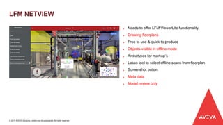
â–² Needs to offer LFM ViewerLite functionality
â–² Drawing floorplans
â–² Free to use & quick to produce
â–² Objects visible in offline mode
▲ Archetypes for markup’s
â–² Lasso tool to select offline scans from floorplan
â–² Screenshot button
â–² Meta data
â–² Model review only
LFM NETVIEW
© 2017 AVEVA Solutions Limited and its subsidiaries. All rights reserved.
FROM THE LAB - LFM NETVIEW 3D
© 2017 AVEVA Solutions Limited and its subsidiaries. All rights reserved.

More Related Content

Americas LFM User Meeting 2018 - Matt Craig, Becht

  • 1. PRESENTATION SUMMARY © 2017 AVEVA Solutions Limited and its subsidiaries. All rights reserved. For many years, LFM Server has been the leader in providing laser scan software solutions for Terrestrial Laser Scan data capture market. LFM Server provides a platform for users to visualize and interact with point cloud data within most engineering design tool applications used in the industry. This presentation demonstrates the functionality of two different point cloud formats (i.e. Terrestrial and Aerial). We will demonstrate how this type of functionality will provide new opportunities for users who use multiple point cloud formats, but need one common platform to visualize and work with the integrated data.
  • 2. â–² Exporting sub-datasets â–² Solid Pointcloud – Volume tools harmonisation â–² Identify pipe route and store volumes (semi-automatic) â–² Rotation of volumes â–² Display angle â–² Rotation point VOLUME MANAGEMENT © 2017 AVEVA Solutions Limited and its subsidiaries. All rights reserved.
  • 3. â–² Scan to model measurement â–² Edge snapping â–² Visual variation analysis â–² Cloud to cloud â–² Cloud to model â–² Continual coordinate reporting with cursor â–² Nozzle (3D lasso) MEASUREMENT © 2017 AVEVA Solutions Limited and its subsidiaries. All rights reserved.
  • 4. â–² Workflow improvements â–² Cylindrical demolition â–² Phased demolition reporting â–² Colours â–² Filter by date VOLUME DEMOLITION © 2017 AVEVA Solutions Limited and its subsidiaries. All rights reserved.
  • 5. â–² Clash numbering – not unique â–² Clash detail improvements â–² Clash reporting â–² User configurable â–² Documented â–² Persistent clash checking â–² 3D coloured points â–² Navisworks clashing â–² PDS clashing CLASHING © 2017 AVEVA Solutions Limited and its subsidiaries. All rights reserved.
  • 6. â–² S3D models inside LFM â–² Opaque or translucent BubbleView display MODELS & MODELLING © 2017 AVEVA Solutions Limited and its subsidiaries. All rights reserved.
  • 7. Grid â–² Change height â–² Change size Floorplan â–² Common CAD format import â–² Multiple level support â–² Use in conjunction with grid Laser drawings â–² Produced in LFM Server â–² Produced in supported CAD systems FLOORPLANS & DRAWINGS © 2017 AVEVA Solutions Limited and its subsidiaries. All rights reserved.
  • 8. â–² Structural tie-in’s â–² Planar selection and segmentation â–² Pipe over CAD link, not C/L CAD LINKS © 2017 AVEVA Solutions Limited and its subsidiaries. All rights reserved.
  • 9. â–² No ‘green’ feedback for less than 5 targets â–² ‘Red’ for not fully constrained viewpoints â–² Automatic target extraction â–² Apply colour spectrum for 3D registration analysis â–² Update scan headers for use in other software â–² Colourising scans from panoramic images â–² Panoramic images project support â–² Meta data GATEWAY MODE © 2017 AVEVA Solutions Limited and its subsidiaries. All rights reserved.
  • 10. â–² Memory management â–² User profiles â–² Configurable mouse action â–² Hot keys â–² Project state stored on closure â–² Orientation cube â–² Crawl mode (Steering Mode) â–² Colour/mono in 3D â–² Power-wheel menu SYSTEM & INTERFACE © 2017 AVEVA Solutions Limited and its subsidiaries. All rights reserved.
  • 11. â–² Needs to offer LFM ViewerLite functionality â–² Drawing floorplans â–² Free to use & quick to produce â–² Objects visible in offline mode â–² Archetypes for markup’s â–² Lasso tool to select offline scans from floorplan â–² Screenshot button â–² Meta data â–² Model review only LFM NETVIEW © 2017 AVEVA Solutions Limited and its subsidiaries. All rights reserved.
  • 12. FROM THE LAB - LFM NETVIEW 3D © 2017 AVEVA Solutions Limited and its subsidiaries. All rights reserved.