Appllications of Remote Sensing.ppt
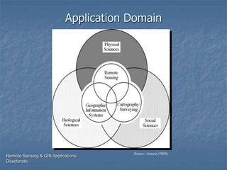
- 2. Remote Sensing & GIS Applications Directorate Source: Jensen (2000) Application Domain
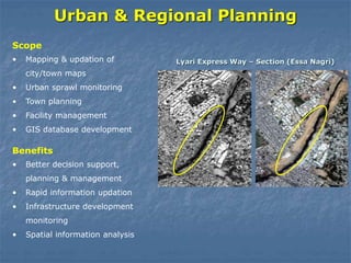
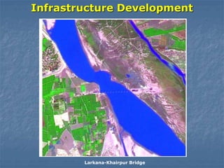
- 3. Urban & Regional Planning âĒ Mapping & updation of city/town maps âĒ Urban sprawl monitoring âĒ Town planning âĒ Facility management âĒ GIS database development Scope Lyari Express Way â Section (Essa Nagri) âĒ Better decision support, planning & management âĒ Rapid information updation âĒ Infrastructure development monitoring âĒ Spatial information analysis Benefits
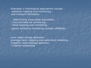
- 4. Examples of hydrological applications include: · .wetlands mapping and monitoring, · .soil moisture estimation, · · determining snow-water equivalent, · . river and lake ice monitoring, · . flood mapping and monitoring, · .glacier dynamics monitoring (surges, ablation) .river /delta change detection · .drainage basin mapping and watershed modelling · .irrigation canal leakage detection · . irrigation scheduling
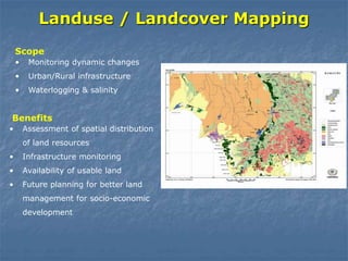
- 5. Landuse / Landcover Mapping âĒ Monitoring dynamic changes âĒ Urban/Rural infrastructure âĒ Waterlogging & salinity Scope âĒ Assessment of spatial distribution of land resources âĒ Infrastructure monitoring âĒ Availability of usable land âĒ Future planning for better land management for socio-economic development Benefits
- 7. Importance of remote sensing Remote Sensing allows data in locations that may be inaccessible or too large for in situ approaches ïŪ Interplanetary studies are an excellent example of where remote sensing is useful âĒ Sample and return missions are expensive and difficult âĒ Apollo missions were last fully successful sample and return missions (Genesis was partially successful) âĒ Still, remote sensing was critical even in those missions to determine where best to sample Meteorological applications âĒ Probably the clearest example with the widest audience and daily impact âĒ Meteorological satellites cover large areas that are inaccessible âĒ Can cover these areas repeatedly to look for changes over time ïŪ National Defense ïŪ Resource Mapping
- 8. Advantages and Limitations of Remote Sensing The major advantages of remote sensing over the ground - based methods are: 1.Synoptic view: Remote sensing process facilitates the study of various features of earth's surface in their spatial relation to each other and helps to delineate the required features and phenomenon. 2.Accessibility: Remote sensing process makes it possible to gather information about the inaccessible area when it is not possible to do ground survey like in mountainous areas or foreign lands. 3.Time: Since information about a large area can be gathered quickly, the techniques save time and efforts of human beings/ or mass. 4.Multi-disciplinary applications: The data gathered by remote sensing process can be used by the users of different disciplines like, geology, forestry land use etc.
- 9. Limitations of Remote Sensing Technology 1. Since resolution of the data from LISS-III is 23.5 M the linear forest cover along roads, canals, bunds, rail of the width less than the resolution are generally not be recorded. 2. young plantations and species having less chlorophyll contents in their crown do not give proper reflectance and as a result are difficult to be interpreted correctly. 3. considerable details on ground may be obscured in areas having clouds and shadows. It is difficult to interpret such areas without the help of collateral data. 4. variation in spectral reflectance during leaf less period poses problems in interpretation. 5. gregarious occurrence of bushy vegetation, such as lantana, sugarcane etc, often poses problems in delineation of forest cover, as their reflectance is similar to that of tree canopy.