Environmental Groundtruthing
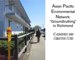
- 1. Asian Pacific Environmental Network: “Groundtruthing” in Richmond H azardous and Sensitive Sites
- 2. Hazardous & Problem Sites
- 4. Our Task • Verify presence and accurate location of existing hazards and sensitive land uses in “Official Sites” databases • Find and record the location of all hazards and sensitive land uses NOT included in “Official Sites” databases • Google Earth- longitudes and latitudes • Input to statewide databases
- 5. Barret & 23 St. rd Sample Data Chart Facility Name Address Description HAZ SR Active Latitude Longitude Contra Costa 2323 Barrett Ave. Richmond, CA Autobody X Yes 122°20'48.33"W Body Shop shop 37°56'19.19"N Arco Gas 2230 Barret & 23rd St. Active Gas X Yes 122°20'52.10"W Station Station 37°56'17.36"N MA Auto & 501 Barret & 23rd St. Autobody X Yes 122°20'52.00"W Tires shop 37°56'19.21"N Sam Auto 521 Barret & 23rd St. Smog Check X Yes 122°20'51.88"W Express 37°56'19.59"N GAO Tires N/A Brakes, X Yes 122°20'50.24"W Alignment, 37°56'22.12"N Shocks
- 6. Petroleum Pipeline near an Apartment Complex on Dover St. Richmond, CA
- 7. United Gas Station Happy Brown Bear Preschool
- 12. Auto Body Shop
- 13. Church Beauty Salon
- 14. Helms Middle school (pubs14, dtsc2)
- 17. McDonalds: A Problem Site


