Au 2008 Gs100 1 P Getting Spatial With
0 likes381 views

This document discusses how to use AutoCAD Map for spatial analysis and multi-user editing of geospatial data. It covers topics like working with vector and raster data, creating and managing feature attributes both internal and linked to external databases, performing common spatial analysis techniques like buffers, overlays, networks and more. Live demos are provided to illustrate working with topologies, joins, calculations and multi-step spatial analysis workflows in AutoCAD Map.
1 of 43
Download to read offline


Ad
Recommended
Mujungi Davis
Mujungi DavisSaid Mujungi
╠²
This document discusses vector GIS database structures. It explains that vector GIS represents the world using points, lines, and polygons. Vector models store discrete data like country borders and streets. Polygons are the basic unit and are created by connecting points with straight lines. Topology encodes spatial relationships between objects to accurately model real-world geometry. Topological rules govern connectivity and adjacency. Building topology involves calculating relationships between points, lines, and areas digitized in a GIS. Topological errors can occur if features do not perfectly connect. Vector databases are widely used in applications like transportation, utilities, and resource management.Datech2014-Session1-Document Representation Refinement for Precise Region Des...
Datech2014-Session1-Document Representation Refinement for Precise Region Des...IMPACT Centre of Competence
╠²
The document discusses the importance of precise region descriptions in document analysis and recognition, highlighting that the current outputs of OCR systems often use imprecise geometric representations. It proposes a polygonal fitting approach to refine these representations by tightly wrapping polygons around document objects, resulting in significantly improved performance in region overlaps and OCR accuracy. The findings indicate that this refinement can enhance the effectiveness of various applications, such as highlighting and cropping.Algorithms for Query Processing and Optimization of Spatial Operations
Algorithms for Query Processing and Optimization of Spatial OperationsNatasha Mandal
╠²
The document discusses algorithms for spatial joins and query processing, focusing on the unique challenges posed by spatial databases compared to traditional relational databases. It outlines various types of spatial queries and operations, highlights the importance of query optimization in terms of time efficiency, and introduces techniques such as spatial indexes and dynamic programming for effective query execution. Additionally, it covers the two-step query processing approach and provides examples of different spatial join methods and their optimizations.Exploiting the query structure for efficient join ordering in SPARQL queries
Exploiting the query structure for efficient join ordering in SPARQL queriesLuiz Henrique Zambom Santana
╠²
The document discusses an innovative join ordering algorithm for SPARQL queries, aiming to improve query optimization by simplifying complex query structures. It introduces techniques for decomposing queries into star-shaped and chain-shaped subqueries, and leverages characteristic sets and pairs to enhance estimation and selectivity in query planning. The analysis highlights the algorithm's efficiency and potential challenges in handling verbose RDF data and the complexity of optimization in SPARQL.Remote Sensing: Overlay Analysis
Remote Sensing: Overlay AnalysisKamlesh Kumar
╠²
The document discusses overlay operations in spatial analysis, highlighting feature and raster overlay methods. It details weighted overlay techniques, emphasizing the importance of assigning weights to criteria and using tools such as raster calculators for integration. Various layers such as rainfall, geology, and land use are mentioned, illustrating how to process and analyze spatial data effectively.Dfg & sg ppt (1)
Dfg & sg ppt (1)shrutishreya14
╠²
This document discusses data flow graphs and sequencing graphs, which are graphical representations used to model the flow of data and operations in digital circuits and information systems. A data flow graph models data dependencies between operations, while a sequencing graph additionally models control flow and hierarchy. Sequencing graphs can model constructs like subroutines, branches, loops, and parallelism. They are used to specify algorithms and simulate hardware. Attributes like delay can be associated with graph elements to estimate performance during synthesis.ML whitepaper v0.2
ML whitepaper v0.2Nathaniel Shimoni
╠²
The document outlines various techniques for automating processes and modeling data using tools like loops, nodes, and specific algorithms such as XGBoost and Random Forest. It explains the use of different node types for reading files, manipulating data, exploring trends, and evaluating model performance. Additionally, it highlights the importance of handling missing data, outliers, and partitioning datasets for training and testing in machine learning workflows.Join Algorithms in MapReduce
Join Algorithms in MapReduceShrihari Rathod
╠²
The document discusses various join algorithms that can be used in MapReduce frameworks. It begins by introducing MapReduce and Hadoop frameworks and explaining the map and reduce phases. It then outlines the objectives of comparing join algorithms. The document goes on to describe several join algorithms - map-side join, reduce-side join, repartition join, broadcast join, trojan join, and replicated join. It explains the process for each algorithm and compares their advantages and issues. Finally, it provides a decision tree for selecting the optimal join algorithm based on factors like schema knowledge, data size, and replication efficiency.Hadoop MapReduce joins
Hadoop MapReduce joinsShalish VJ
╠²
The document discusses different types of joins that can be performed in MapReduce including reduce-side joins, replicated joins, and composite joins. Reduce-side joins perform the join operation in the reducer by shuffling all the data to the reducers based on the join key. Replicated joins load smaller datasets into memory on the mapper to perform the join without a shuffle. Composite joins require preprocessed and sorted data to perform the join entirely on the mapper without a shuffle for inner and full outer joins.Network Analysis in ArcGIS
Network Analysis in ArcGISJohn Reiser
╠²
This document discusses network analysis in GIS. It describes how network analysis focuses on representing real-world networks as edge-node topologies. It discusses the basics of edges, nodes and network connectivity. It also outlines some key network properties like cost to traverse, restrictions, and temporal information. Finally, it discusses how to set up network analysis in ArcGIS and some common network analysis tasks.K-Means Algorithm Implementation In python
K-Means Algorithm Implementation In pythonAfzal Ahmad
╠²
The document presents a project on categorizing Stack Overflow users using the k-means clustering algorithm. It details the dataset obtained from Stack Exchange, focusing on user features such as age, reputation, upvotes, and downvotes, and explains the data preprocessing needed to convert XML data into CSV format for analysis. Insights derived from the analysis indicate that younger users are more active in terms of engagement compared to older users.Lec5 Pagerank
Lec5 PagerankJeff Hammerbacher
╠²
This document summarizes a lecture on graph algorithms and PageRank using MapReduce. It discusses representing graphs in MapReduce, performing breadth-first search, finding shortest paths, and calculating PageRank through an iterative process of redistributing PageRank values along edges in the graph. The PageRank algorithm is broken into phases that map nodes to PageRank fragments, reduce to calculate new PageRank values, and iterate until convergence is reached. While MapReduce has limitations for iterative algorithms, this approach allows processing graph partitions in parallel through multiple MapReduce jobs.presentation
presentationjie ren
╠²
This document presents a scheme for interactive communication between a base station and mobile stations to efficiently allocate resources. It models the problem and analyzes an approach where the base station broadcasts a threshold and mobile stations reply to indicate if their value is above or below it. Through multiple rounds of interaction, the base station can determine the mobile station with the maximum value with significantly less overhead than non-interactive schemes. Simulation results show the proposed approach of encoding the threshold or number of users at each round performs better than baselines. Extensions consider incorporating distortion and trading off communication costs versus time.Text to speech conversation in gujarati
Text to speech conversation in gujaratiAshvin Nakum
╠²
This document describes a text-to-speech conversion process using MATLAB. It involves 3 main steps: 1) Scanning text into a JPEG image, 2) Using optical character recognition on the image to recognize words, 3) Converting the recognized text into speech using pre-recorded audio files in MATLAB. Optical character recognition works by converting the image to grayscale, then binary, and matching characters to templates using correlation. This allows scanned text to be read aloud, helping blind people access written content through audio.[Seminar] 200508 hyunwook lee
[Seminar] 200508 hyunwook leeivaderivader
╠²
This document summarizes the Traffic Graph Convolutional Recurrent Neural Network framework for network-scale traffic learning and forecasting. The framework uses a graph convolutional layer to capture road properties in the graph structure using k-hop adjacency matrices. It then introduces a temporal graph convolutional LSTM cell that applies neighboring node importance to the cell state. This allows the model to easily expand and consider richer features than other models while remaining interpretable. The ability to include k-hop relationships and flexibility to model other tasks are cited as benefits over previous work in traffic prediction and modeling.Spatial
Spatialsqlserver.co.il
╠²
Spatial data types allow for location-based queries by representing geometric objects like points, lines, and polygons. SQL Server supports both flat (GEOMETRY) and round earth (GEOGRAPHY) spatial data types that adhere to Open Geospatial Consortium standards. Spatial data can be input and output in different formats and queried using spatial methods and indexed for performance with spatial indexes.Lecture+12+topology+2013 (3)
Lecture+12+topology+2013 (3)Mei Chi Lo
╠²
This document provides an overview of geographic information systems (GIS) and topology. It discusses how GIS uses topology to represent spatial relationships between geometric objects and define properties like connectivity, area definition, and contiguity. The document outlines sources of errors in GIS data and describes techniques for building and validating topology to identify errors. It provides examples of topological rules and explains how Esri's ArcGIS software is used to create, validate, and fix topology errors in GIS vector data.Repartition join in mapreduce
Repartition join in mapreduceUday Vakalapudi
╠²
This document discusses reduce-side joins in Hadoop. Reduce-side joins are performed by joining datasets in the reduce phase based on a join key. The data is organized by Hadoop to send identical keys to the same reducer, making reduce-side joins straightforward to implement. However, performance can suffer as all data is shuffled across the network. The document outlines the steps to perform a reduce-side join which include tagging each dataset with an identity, creating a composite key, partitioning and sorting the data, then joining in the reducer based on the key.008 20151221 Return of Frustrating Easy Domain Adaptation
008 20151221 Return of Frustrating Easy Domain AdaptationHa Phuong
╠²
The document proposes a simple and effective method called CORrelation ALignment (CORAL) for unsupervised domain adaptation. CORAL minimizes domain shift by aligning the second-order statistics of the source and target distributions without requiring any target labels. The method whitens the source distribution and recolors it with the target covariance matrix. Experiments on object recognition and sentiment analysis tasks show CORAL outperforms other unsupervised domain adaptation methods.Geographical information system
Geographical information systemSatya Prakash Dalei
╠²
This document discusses various GIS analysis techniques including buffering, overlay, and distance measurement. Buffering creates zones around features, which can be used for planning purposes like restricting certain land uses near schools. Overlay combines data layers by joining features that occupy the same space. Feature overlay splits features where they overlap, while raster overlay combines characteristics across layers. Overlay is useful for queries and modeling. Distance measurement finds straight-line distances between features for analysis and pattern detection.Geolectioxydata
Geolectioxydatadave west
╠²
This document provides a 3-step process for adding XY data to ArcMap:
1) Convert data from an XYZ format to a CSV format with column headers for X, Y, and Z coordinates
2) Open ArcMap, use the "Add XY Data" tool to browse and select the CSV file
3) Define the coordinate system by selecting the appropriate geographic or projected system to display the points in ArcMap.Vector data model
Vector data modelNaresh Kumar
╠²
Three fundamental vector types exist in GISs: points, lines, and polygons. Points contain a single coordinate pair and represent discrete features. Lines are composed of multiple connected points and represent linear features. Polygons are created by multiple lines that loop back and represent two-dimensional features bounded by closed lines.Big Data and Geospatial with HPCC Systems
Big Data and Geospatial with HPCC SystemsHPCC Systems
╠²
The document discusses the integration of geospatial data within HPCC Systems, emphasizing the importance of understanding data formats and projections. It outlines processes for ingesting and querying both vector and raster data, and highlights the challenges and solutions related to geospatial analysis. The document promotes the benefits of using HPCC for efficient data processing and spatial analysis in big data contexts.Introduction of data structure
Introduction of data structureeShikshak
╠²
This document introduces key concepts in data structures and algorithms. It defines an algorithm as a set of instructions to accomplish a task, and discusses how algorithms are evaluated based on their time and space complexity. It then defines data structures as organized data with relationships and permitted operations, and lists common examples like arrays, stacks and queues. The document also introduces abstract data types as mathematical models with defined operations.Hadoop Mapreduce joins
Hadoop Mapreduce joinsUday Vakalapudi
╠²
The document discusses different types of joins that can be performed in MapReduce including map-side joins and reduce-side joins. Map-side joins include replicated joins, where a small dataset is copied to each node and joined with the larger dataset, and semi-joins, where an initial large dataset is filtered before the join. Reduce-side joins, also called repartition joins, involve joining datasets in the reduce phase by setting the join key as the map output key so datasets are colocated for joining. Inequality joins are difficult to implement in MapReduce's key-equality paradigm.Understandung Firebird optimizer, by Dmitry Yemanov (in English)
Understandung Firebird optimizer, by Dmitry Yemanov (in English)Alexey Kovyazin
╠²
The document discusses Firebird's query optimizer. It explains that the optimizer analyzes statistical information to retrieve data in the most efficient way. It can use rule-based or cost-based strategies. Rule-based uses heuristics while cost-based calculates costs based on statistics. The optimizer prepares queries, calculates costs of different plans, and chooses the most efficient plan based on selectivity, cardinality, and cost metrics. It relies on up-to-date statistics stored in the database to estimate costs and make optimization decisions.Firebird: cost-based optimization and statistics, by Dmitry Yemanov (in English)
Firebird: cost-based optimization and statistics, by Dmitry Yemanov (in English)Alexey Kovyazin
╠²
This document discusses cost-based optimization and statistics in Firebird. It covers:
1) Rule-based optimization uses heuristics while cost-based optimization uses statistical data to estimate the cost of different access paths and choose the most efficient.
2) Statistics like selectivity, cardinality, and histograms help estimate costs by providing information on data distribution and amounts.
3) The optimizer aggregates costs from the bottom up and chooses the access path with the lowest total cost based on the statistical information.Network Analysis
Network Analysisami_01
╠²
This document discusses network analysis and its various types and applications. It provides an overview of network analysis, describes how ArcGIS Network Analyst can be used to perform different network analysis tasks like finding routes, service areas, closest facilities, and vehicle routing. It also explains key concepts in network analysis like network datasets, impedance, and location-allocation analysis.Au09 Presentation Ut118 1
Au09 Presentation Ut118 1Richard Chappell, GISP
╠²
The document outlines the integration of GIS (Geographic Information Systems) with AutoCAD Map 3D, highlighting methodologies for managing geospatial data, including various storage models and the design elements necessary for effective GIS implementation. It discusses essential concepts such as data normalization, entity-relationship modeling, and spatial relationships, alongside application examples across utilities. The aim is to provide insights for better decision-making in GIS design and applications to address business challenges efficiently.ÓĖäÓĖ╣Ó╣łÓĖĪÓĖĘÓĖŁÓĖüÓĖ▓ÓĖŻÓ╣āÓĖŖÓ╣ēÓĖćÓĖ▓ÓĖÖÓ╣ĆÓĖ¦Ó╣ćÓĖÜ Linkedin
ÓĖäÓĖ╣Ó╣łÓĖĪÓĖĘÓĖŁÓĖüÓĖ▓ÓĖŻÓ╣āÓĖŖÓ╣ēÓĖćÓĖ▓ÓĖÖÓ╣ĆÓĖ¦Ó╣ćÓĖÜ LinkedinGore Kittipoom
╠²
ÓĖäÓĖ╣Ó╣łÓĖĪÓĖĘÓĖŁÓĖüÓĖ▓ÓĖŻÓ╣āÓĖŖÓ╣ēÓĖćÓĖ▓ÓĖÖÓ╣ĆÓĖ¦Ó╣ćÓĖÜ LinkedinMore Related Content
What's hot (20)
Hadoop MapReduce joins
Hadoop MapReduce joinsShalish VJ
╠²
The document discusses different types of joins that can be performed in MapReduce including reduce-side joins, replicated joins, and composite joins. Reduce-side joins perform the join operation in the reducer by shuffling all the data to the reducers based on the join key. Replicated joins load smaller datasets into memory on the mapper to perform the join without a shuffle. Composite joins require preprocessed and sorted data to perform the join entirely on the mapper without a shuffle for inner and full outer joins.Network Analysis in ArcGIS
Network Analysis in ArcGISJohn Reiser
╠²
This document discusses network analysis in GIS. It describes how network analysis focuses on representing real-world networks as edge-node topologies. It discusses the basics of edges, nodes and network connectivity. It also outlines some key network properties like cost to traverse, restrictions, and temporal information. Finally, it discusses how to set up network analysis in ArcGIS and some common network analysis tasks.K-Means Algorithm Implementation In python
K-Means Algorithm Implementation In pythonAfzal Ahmad
╠²
The document presents a project on categorizing Stack Overflow users using the k-means clustering algorithm. It details the dataset obtained from Stack Exchange, focusing on user features such as age, reputation, upvotes, and downvotes, and explains the data preprocessing needed to convert XML data into CSV format for analysis. Insights derived from the analysis indicate that younger users are more active in terms of engagement compared to older users.Lec5 Pagerank
Lec5 PagerankJeff Hammerbacher
╠²
This document summarizes a lecture on graph algorithms and PageRank using MapReduce. It discusses representing graphs in MapReduce, performing breadth-first search, finding shortest paths, and calculating PageRank through an iterative process of redistributing PageRank values along edges in the graph. The PageRank algorithm is broken into phases that map nodes to PageRank fragments, reduce to calculate new PageRank values, and iterate until convergence is reached. While MapReduce has limitations for iterative algorithms, this approach allows processing graph partitions in parallel through multiple MapReduce jobs.presentation
presentationjie ren
╠²
This document presents a scheme for interactive communication between a base station and mobile stations to efficiently allocate resources. It models the problem and analyzes an approach where the base station broadcasts a threshold and mobile stations reply to indicate if their value is above or below it. Through multiple rounds of interaction, the base station can determine the mobile station with the maximum value with significantly less overhead than non-interactive schemes. Simulation results show the proposed approach of encoding the threshold or number of users at each round performs better than baselines. Extensions consider incorporating distortion and trading off communication costs versus time.Text to speech conversation in gujarati
Text to speech conversation in gujaratiAshvin Nakum
╠²
This document describes a text-to-speech conversion process using MATLAB. It involves 3 main steps: 1) Scanning text into a JPEG image, 2) Using optical character recognition on the image to recognize words, 3) Converting the recognized text into speech using pre-recorded audio files in MATLAB. Optical character recognition works by converting the image to grayscale, then binary, and matching characters to templates using correlation. This allows scanned text to be read aloud, helping blind people access written content through audio.[Seminar] 200508 hyunwook lee
[Seminar] 200508 hyunwook leeivaderivader
╠²
This document summarizes the Traffic Graph Convolutional Recurrent Neural Network framework for network-scale traffic learning and forecasting. The framework uses a graph convolutional layer to capture road properties in the graph structure using k-hop adjacency matrices. It then introduces a temporal graph convolutional LSTM cell that applies neighboring node importance to the cell state. This allows the model to easily expand and consider richer features than other models while remaining interpretable. The ability to include k-hop relationships and flexibility to model other tasks are cited as benefits over previous work in traffic prediction and modeling.Spatial
Spatialsqlserver.co.il
╠²
Spatial data types allow for location-based queries by representing geometric objects like points, lines, and polygons. SQL Server supports both flat (GEOMETRY) and round earth (GEOGRAPHY) spatial data types that adhere to Open Geospatial Consortium standards. Spatial data can be input and output in different formats and queried using spatial methods and indexed for performance with spatial indexes.Lecture+12+topology+2013 (3)
Lecture+12+topology+2013 (3)Mei Chi Lo
╠²
This document provides an overview of geographic information systems (GIS) and topology. It discusses how GIS uses topology to represent spatial relationships between geometric objects and define properties like connectivity, area definition, and contiguity. The document outlines sources of errors in GIS data and describes techniques for building and validating topology to identify errors. It provides examples of topological rules and explains how Esri's ArcGIS software is used to create, validate, and fix topology errors in GIS vector data.Repartition join in mapreduce
Repartition join in mapreduceUday Vakalapudi
╠²
This document discusses reduce-side joins in Hadoop. Reduce-side joins are performed by joining datasets in the reduce phase based on a join key. The data is organized by Hadoop to send identical keys to the same reducer, making reduce-side joins straightforward to implement. However, performance can suffer as all data is shuffled across the network. The document outlines the steps to perform a reduce-side join which include tagging each dataset with an identity, creating a composite key, partitioning and sorting the data, then joining in the reducer based on the key.008 20151221 Return of Frustrating Easy Domain Adaptation
008 20151221 Return of Frustrating Easy Domain AdaptationHa Phuong
╠²
The document proposes a simple and effective method called CORrelation ALignment (CORAL) for unsupervised domain adaptation. CORAL minimizes domain shift by aligning the second-order statistics of the source and target distributions without requiring any target labels. The method whitens the source distribution and recolors it with the target covariance matrix. Experiments on object recognition and sentiment analysis tasks show CORAL outperforms other unsupervised domain adaptation methods.Geographical information system
Geographical information systemSatya Prakash Dalei
╠²
This document discusses various GIS analysis techniques including buffering, overlay, and distance measurement. Buffering creates zones around features, which can be used for planning purposes like restricting certain land uses near schools. Overlay combines data layers by joining features that occupy the same space. Feature overlay splits features where they overlap, while raster overlay combines characteristics across layers. Overlay is useful for queries and modeling. Distance measurement finds straight-line distances between features for analysis and pattern detection.Geolectioxydata
Geolectioxydatadave west
╠²
This document provides a 3-step process for adding XY data to ArcMap:
1) Convert data from an XYZ format to a CSV format with column headers for X, Y, and Z coordinates
2) Open ArcMap, use the "Add XY Data" tool to browse and select the CSV file
3) Define the coordinate system by selecting the appropriate geographic or projected system to display the points in ArcMap.Vector data model
Vector data modelNaresh Kumar
╠²
Three fundamental vector types exist in GISs: points, lines, and polygons. Points contain a single coordinate pair and represent discrete features. Lines are composed of multiple connected points and represent linear features. Polygons are created by multiple lines that loop back and represent two-dimensional features bounded by closed lines.Big Data and Geospatial with HPCC Systems
Big Data and Geospatial with HPCC SystemsHPCC Systems
╠²
The document discusses the integration of geospatial data within HPCC Systems, emphasizing the importance of understanding data formats and projections. It outlines processes for ingesting and querying both vector and raster data, and highlights the challenges and solutions related to geospatial analysis. The document promotes the benefits of using HPCC for efficient data processing and spatial analysis in big data contexts.Introduction of data structure
Introduction of data structureeShikshak
╠²
This document introduces key concepts in data structures and algorithms. It defines an algorithm as a set of instructions to accomplish a task, and discusses how algorithms are evaluated based on their time and space complexity. It then defines data structures as organized data with relationships and permitted operations, and lists common examples like arrays, stacks and queues. The document also introduces abstract data types as mathematical models with defined operations.Hadoop Mapreduce joins
Hadoop Mapreduce joinsUday Vakalapudi
╠²
The document discusses different types of joins that can be performed in MapReduce including map-side joins and reduce-side joins. Map-side joins include replicated joins, where a small dataset is copied to each node and joined with the larger dataset, and semi-joins, where an initial large dataset is filtered before the join. Reduce-side joins, also called repartition joins, involve joining datasets in the reduce phase by setting the join key as the map output key so datasets are colocated for joining. Inequality joins are difficult to implement in MapReduce's key-equality paradigm.Understandung Firebird optimizer, by Dmitry Yemanov (in English)
Understandung Firebird optimizer, by Dmitry Yemanov (in English)Alexey Kovyazin
╠²
The document discusses Firebird's query optimizer. It explains that the optimizer analyzes statistical information to retrieve data in the most efficient way. It can use rule-based or cost-based strategies. Rule-based uses heuristics while cost-based calculates costs based on statistics. The optimizer prepares queries, calculates costs of different plans, and chooses the most efficient plan based on selectivity, cardinality, and cost metrics. It relies on up-to-date statistics stored in the database to estimate costs and make optimization decisions.Firebird: cost-based optimization and statistics, by Dmitry Yemanov (in English)
Firebird: cost-based optimization and statistics, by Dmitry Yemanov (in English)Alexey Kovyazin
╠²
This document discusses cost-based optimization and statistics in Firebird. It covers:
1) Rule-based optimization uses heuristics while cost-based optimization uses statistical data to estimate the cost of different access paths and choose the most efficient.
2) Statistics like selectivity, cardinality, and histograms help estimate costs by providing information on data distribution and amounts.
3) The optimizer aggregates costs from the bottom up and chooses the access path with the lowest total cost based on the statistical information.Network Analysis
Network Analysisami_01
╠²
This document discusses network analysis and its various types and applications. It provides an overview of network analysis, describes how ArcGIS Network Analyst can be used to perform different network analysis tasks like finding routes, service areas, closest facilities, and vehicle routing. It also explains key concepts in network analysis like network datasets, impedance, and location-allocation analysis.Viewers also liked (7)
Au09 Presentation Ut118 1
Au09 Presentation Ut118 1Richard Chappell, GISP
╠²
The document outlines the integration of GIS (Geographic Information Systems) with AutoCAD Map 3D, highlighting methodologies for managing geospatial data, including various storage models and the design elements necessary for effective GIS implementation. It discusses essential concepts such as data normalization, entity-relationship modeling, and spatial relationships, alongside application examples across utilities. The aim is to provide insights for better decision-making in GIS design and applications to address business challenges efficiently.ÓĖäÓĖ╣Ó╣łÓĖĪÓĖĘÓĖŁÓĖüÓĖ▓ÓĖŻÓ╣āÓĖŖÓ╣ēÓĖćÓĖ▓ÓĖÖÓ╣ĆÓĖ¦Ó╣ćÓĖÜ Linkedin
ÓĖäÓĖ╣Ó╣łÓĖĪÓĖĘÓĖŁÓĖüÓĖ▓ÓĖŻÓ╣āÓĖŖÓ╣ēÓĖćÓĖ▓ÓĖÖÓ╣ĆÓĖ¦Ó╣ćÓĖÜ LinkedinGore Kittipoom
╠²
ÓĖäÓĖ╣Ó╣łÓĖĪÓĖĘÓĖŁÓĖüÓĖ▓ÓĖŻÓ╣āÓĖŖÓ╣ēÓĖćÓĖ▓ÓĖÖÓ╣ĆÓĖ¦Ó╣ćÓĖÜ LinkedinCivil 3 d overview general
Civil 3 d overview generalKushal Patel
╠²
The document discusses the user interface and tools in AutoCAD Civil 3D. It describes the standard AutoCAD tools and additional civil design tools in the interface. It then explains key tools for creating points, surfaces, alignments, parcels, profiles, assemblies, corridors, intersections, sample lines, section views, and pipe networks. Civil 3D allows users to design civil engineering projects with tools for terrain modeling, road design, pipe networks, and other tasks.Harness The Power Of Auto Cad Map And Esri
Harness The Power Of Auto Cad Map And EsriRichard Chappell, GISP
╠²
The document discusses harnessing the integrated power of AutoCAD Map 3D and ESRI software through Autodesk's interoperability tools. It introduces Richard Chappell, a geospatial application engineer, and outlines the objective to clarify the CAD to GIS discussion and understand Autodesk's interoperability solutions. The agenda includes identifying issues with CAD and GIS integration, reviewing the technologies, examining solutions, and practicing the solutions.Autocad Civil3d for Surveyors (Stringer)
Autocad Civil3d for Surveyors (Stringer)Jason_Coghlan16
╠²
This document summarizes AutoCAD Civil 3D software for surveyors. It discusses how Civil 3D simplifies data and allows for easy revision control and transfer of survey data between drafting and design software without data loss or need to recreate. It also lists the key components and capabilities of Civil 3D such as importing survey data, creating surfaces and volumes, labeling styles, and utilities for survey drafting. Finally, it promotes a survey utility developed in Australia that seamlessly integrates with Civil 3D to further help with tasks like managing survey data, creating breaklines, and editing point displays.Map Tools in AutoCAD Civil 3D
Map Tools in AutoCAD Civil 3DRichard Chappell, GISP
╠²
Richard Chappell, a Geospatial Application Engineer at Cadsoft Consulting, highlights the capabilities of the Map 3D tools in Civil 3D for enhancing planning, design, and management of infrastructure projects. The tools offer access to diverse data sets, improve workflow with advanced geometry editing, and provide powerful analysis capabilities. Additionally, the document discusses the importance of clean geometry and topology management for effective data usage in geospatial applications.Autodesk civil3 d_tutorail
Autodesk civil3 d_tutorailKushal Patel
╠²
This document discusses project management in AutoCAD Civil 3D. It describes three common ways to organize Civil 3D projects: a single design drawing, multiple drawings sharing data using shortcuts, or multiple drawings sharing data using Autodesk Vault. It also discusses how to use data shortcuts to share design data between drawings through XML files, allowing collaboration on a project. Updates to shared data are synchronized when drawings are opened.Ad
Similar to Au 2008 Gs100 1 P Getting Spatial With (20)
Topology in GIS
Topology in GISRohit Kumar
╠²
Topology refers to the spatial relationships between GIS features or objects. It is important for network routing and maintaining data quality and integrity when features are shared across layers. Geodatabases provide the strongest topological functionality, storing relationships in topology rules and feature classes. The node-arc data model represents the most common topology, with nodes at intersections and endpoints and arcs between nodes forming polygons. Topology allows for analysis without coordinate data but establishing topology is time-consuming.Agic 2009 Getting Spatial Map
Agic 2009 Getting Spatial MapRichard Chappell, GISP
╠²
The document provides an overview of spatial analysis tools in AutoCAD Map 3D. It discusses two approaches to spatial analysis - using topologies of AutoCAD objects or connecting to feature data using FDO. The hands-on exercises demonstrate how to create network and polygon topologies, perform network analysis, and analyze features using buffers and overlays both with and without topologies.Gis Concepts 5/5
Gis Concepts 5/5CIER Facultad de Agronom├Ła
╠²
The document covers the concepts and functionalities of Geographic Information Systems (GIS), detailing its role as an information technology that processes spatial data through various analyses. It explains methods such as spatial analysis, georeferencing, database management, and multi-criteria location analysis, emphasizing the importance of topological properties in vector and raster datasets. The presentation outlines various analytical functions used to derive information not inherently present in the datasets, highlighting their significance in answering complex geographic questions.Agic 2009 Losing My Religion Gis Interoperability
Agic 2009 Losing My Religion Gis InteroperabilityRichard Chappell, GISP
╠²
The document discusses interoperability between CAD and GIS software, aiming to clarify misconceptions and outline tools for effective data exchange. Key topics include data structure differences, integration barriers, and methods for data interchange, emphasizing the need for understanding data purpose and lifecycle requirements. It concludes by highlighting the importance of developing workflows that optimize data utilization.GIS_Data_models.ppt Dr. Rapanwad Sunil Ramrao
GIS_Data_models.ppt Dr. Rapanwad Sunil RamraoDrSunilRapanwad
╠²
The document provides an overview of GIS data models, focusing on vector and raster data models, their structures, and implications for data abstraction. It discusses key concepts such as points, lines, and polygons, as well as topology and the importance of understanding relationships in spatial data. Additionally, the document covers file formats, examples of GIS applications, and references for further reading.TerraWorld
TerraWorldMohammad Ullah Khan, MAusIMM (Ph.D)
╠²
This document discusses integrated analysis of spatial and non-spatial data in geographic information systems (GIS). It defines GIS and describes how spatial data includes location, shape and size attributes and can be represented as rasters or vectors, while non-spatial data provides additional information linked to spatial features. The document outlines common spatial analysis functions like overlay and neighborhood analysis that integrate both data types to answer questions about real-world features and relationships.Data Models - GIS I
Data Models - GIS IJohn Reiser
╠²
GIS models reality through abstraction using a mix of raster, vector, and attribute data tailored to specific functions. Topological vector models record shared geometries like points and lines only once, allowing features to be connected and ensuring integrity as changes propagate between related features. Object-oriented models represent real-world phenomena as interconnected objects with their own rules and relationships.GIS Data Types
GIS Data TypesJohn Reiser
╠²
The document discusses the two major families of GIS data: raster and vector, explaining their characteristics and applications. It covers the limitations of raster data, the representation of points, lines, and polygons with vector data, normalization in database design, and the best practices for managing GIS systems. Additionally, it introduces OpenStreetMap as an alternative GIS model with its unique data storage and collaborative updating features.Au 2007 ItŌĆÖS Not Cad To Gis Final
Au 2007 ItŌĆÖS Not Cad To Gis FinalRichard Chappell, GISP
╠²
This document discusses issues related to managing data across design and facility management organizations. It aims to dispel myths about CAD and GIS data and identify technical and non-technical integration barriers. While data transfer between CAD and GIS formats is technically possible, the primary barriers are related to how the data is organized and used for different purposes throughout the design and facility management lifecycle. The document recommends focusing on common data requirements and developing standards around layering, symbols, geometry, and attributes to better integrate CAD design data into GIS for facility management.Data models in geographical information system(GIS)
Data models in geographical information system(GIS)PRAMODA G
╠²
The document provides an overview of key concepts in geographic information systems (GIS) including common data models. It discusses the two main data models - raster and vector - explaining their characteristics, advantages, and disadvantages. Additionally, it covers triangulated irregular network (TIN) models and digital elevation models (DEMs) which are other important data representations in GIS. The document concludes that raster and vector are the basic GIS data models and explores their differences and various modeling approaches.Mujungi Davis
Mujungi DavisSaid Mujungi
╠²
This document discusses vector GIS database structures. It explains that vector GIS represents the world using points, lines, and polygons. Vector models store discrete data like country borders and streets. Polygons are the basic unit and are created by connecting points with straight lines. Topology encodes spatial relationships between objects to accurately model real-world geometry. Topological rules govern connectivity and adjacency. Building topology involves calculating relationships between points, lines, and areas digitized in a GIS. Topological errors can occur if features do not perfectly connect. Vector databases are widely used in applications like transportation, utilities, and resource management.Conceptual models of real world geographical phenomena (epm107_2007)
Conceptual models of real world geographical phenomena (epm107_2007)esambale
╠²
Conceptual models of geographical phenomena abstract and simplify aspects of reality for representation in geographic information systems (GIS). Data can be represented as discrete entities with boundaries or precise attributes, or as continuous fields that vary smoothly over space. GIS uses both vector and raster data structures, with vectors best for objects and topology but rasters more suitable for analysis of continuous surface variables like elevation.Arcgis training day_2
Arcgis training day_2yashasweesharma
╠²
The document discusses several GIS analysis tools and functions in ArcMap including adding XY data, buffering, selections, editing operations like sketching and modifying features, topology rules, and building a geometric network. Key steps are outlined for using tools like the buffer wizard, selections by location, sketch contexts, extending and trimming features, defining topology rules, and creating a geometric network by selecting layers and defining edges and junctions. Examples provided illustrate identifying buildings affected by road widening and selecting roads within or crossing a boundary.Arc gis desktop_and_geoprocessing
Arc gis desktop_and_geoprocessingEsri
╠²
This document provides an overview and introduction to ArcGIS Desktop. It summarizes the key components of ArcGIS Desktop including ArcMap for visualization and analysis, ArcCatalog for data management, and a variety of extensions for specific analysis types. It also discusses working with different data formats, editing data, geoprocessing tools and workflows, and options for sharing maps, layers and other resources. The document aims to give attendees an understanding of the capabilities and components of ArcGIS Desktop.Data input and transformation
Data input and transformationMohsin Siddique
╠²
This document provides an overview of remote sensing and geographical information systems (GIS) in civil engineering. It discusses key concepts like vector and raster data models, data coding, representation of geographic features as points, lines and areas, common vector data structures including topology and dual independent map encoding, and data compression techniques. The course will cover GIS software, spatial queries, analysis functions, and practice generating hydrological modeling inputs like digital elevation models and flow maps from terrain data.Four data models in GIS
Four data models in GISProf. A.Balasubramanian
╠²
The document discusses four data models in Geographic Information Systems (GIS): vector, raster, triangulated irregular network (TIN), and digital elevation models (DEM). Vector data represents geographic features as points, lines, and polygons, while raster data is a grid of cells representing continuous data. Each model has its advantages and disadvantages in terms of structure, complexity, and suitability for different types of analysis and representations of spatial phenomena.Spatial data for GIS
Spatial data for GISAl Nahian Avro
╠²
The document discusses spatial data, which identifies geographic locations and is used in Geographic Information Systems (GIS). It outlines two primary types of spatial data: vector data, characterized by points, lines, and polygons with advantages such as accurate representation of shape, and raster data, defined by pixel values suitable for continuously changing values. The document also highlights the advantages and disadvantages of both data types and sources for GIS data.Seminar on gis analysis functions
Seminar on gis analysis functionsPRAMODA G
╠²
This document provides an overview of geographic information system (GIS) analysis functions. It discusses several types of analysis that GIS is used for, including selection and measurement, overlay analysis, neighbourhood operations, and connectivity analysis. Overlay analysis allows for spatially interrelating multiple data layers and is one of the most important GIS functions. Neighbourhood operations consider characteristics of surrounding areas, such as through buffering or interpolation. Overall, the document outlines the key spatial analysis techniques that GIS provides for examining geographic data patterns and relationships.Modelo de dados vetorial e matricial - slides
Modelo de dados vetorial e matricial - slidesLuzianeRibeiroIndjai
╠²
1. Raster data models represent geographic space as a grid of cells, with each cell storing attribute values. Vector data models represent geographic features as points, lines, or polygons.
2. The vector topological data model explicitly stores the topological relationships between geometric features, enforcing planarity. The spaghetti vector model does not store topology.
3. Raster data can be stored in a database and linked to attribute tables. Vector data can also be stored in integrated geodatabases that implement both the topological and spaghetti models.Ad
Au 2008 Gs100 1 P Getting Spatial With
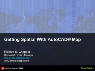
- 1. Getting Spatial With AutoCAD® Map Richard E. Chappell Geospatial Territory Manager Rick.Chappell@gmail.com www.richardchappell.com
- 2. Objectives After attending this session, you will be able to: ’é¦ Work with AutoCAD Map in multi-user environments ’é¦ Understand spatial analysis and some of its uses ’é¦ Understand how data is used for spatial analysis ’é¦ Create smarter AutoCAD Drawings for data mining ’é¦ Perform common types of spatial analysis with AutoCAD Map
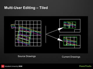
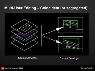
- 3. Teamwork: Multi-user editing Increase your effectiveness by sharing the load
- 4. Multi-User Editing ŌĆō Tiled Source Drawings Current Drawings
- 5. Multi-User Editing ŌĆō Coincident (or segregated) Source Drawings Current Drawings
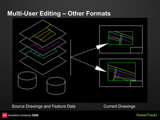
- 6. Multi-User Editing ŌĆō Other Formats Source Drawings and Feature Data Current Drawings
- 8. Spaghetti and Meatballs: Working with features Getting to know the parts and pieces
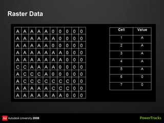
- 9. Raster Data
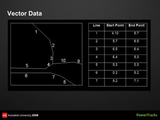
- 11. Vector Data
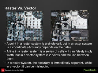
- 12. Raster Vs. Vector ’é¦ A point in a raster system is a single cell, but in a raster system is a coordinate (Accuracy depends on the data) ’é¦ A line in a raster system is a series of cells ŌĆō it can falsely imply width, but in a vector system is 2 points and the line between them ’é¦ In a raster system, the accuracy is immediately apparent, while in a vector, it can be misleading
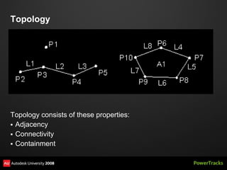
- 13. Topology Topology consists of these properties: ’é¦ Adjacency ’é¦ Connectivity ’é¦ Containment
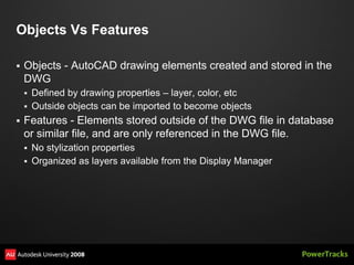
- 14. Objects Vs Features ’é¦ Objects - AutoCAD drawing elements created and stored in the DWG ’é¦ Defined by drawing properties ŌĆō layer, color, etc ’é¦ Outside objects can be imported to become objects ’é¦ Features - Elements stored outside of the DWG file in database or similar file, and are only referenced in the DWG file. ’é¦ No stylization properties ’é¦ Organized as layers available from the Display Manager
- 15. Topologies - Types Point (or Node) Topology ’é¦ Created from AutoCAD points, blocks or text ’é¦ A new object table gets created ŌĆō TPMNODE_topologyname Lines (or network, link or chain) Topology ’é¦ Created from lines, open polylines or arcs ’é¦ A new object table gets created ŌĆō TPMLINK_topologyname ’é¦ If you create nodes at the same time, a node object table gets created as well Polygon Topology ’é¦ Created from a set of lines, open polylines or arcs that enclose an area. It may or may not have a centroid ’é¦ A new object table gets created ŌĆō TPMCNTR_topologyname ’é¦ A link tabe is defined, and a node may be defined
- 18. It's not dumb data: Managing Attributes The heart of the matter is information
- 19. Object Data ’é¦ Data tables stored in the drawing ’é¦ AutoCAD Map 3D only ’é¦ Tables are automatically created during topology creation ’é¦ Tables are created for data imported from other formats, such as ESRI Shape files ’é¦ Create using ADEDEFDATA ’é¦ Add records and attach to object with ADEATTACHDATA ’é¦ View or edit the data with ADEEDITDATA ’é¦ Only accessible to Map users ’é¦ Best if data is relatively static, such as descriptive characteristics
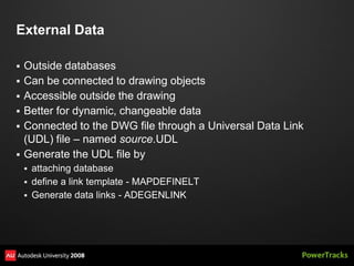
- 20. External Data ’é¦ Outside databases ’é¦ Can be connected to drawing objects ’é¦ Accessible outside the drawing ’é¦ Better for dynamic, changeable data ’é¦ Connected to the DWG file through a Universal Data Link (UDL) file ŌĆō named source.UDL ’é¦ Generate the UDL file by ’é¦ attaching database ’é¦ define a link template - MAPDEFINELT ’é¦ Generate data links - ADEGENLINK
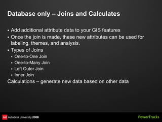
- 22. Database only ŌĆō Joins and Calculates ’é¦ Add additional attribute data to your GIS features ’é¦ Once the join is made, these new attributes can be used for labeling, themes, and analysis. ’é¦ Types of Joins ’é¦ One-to-One Join ’é¦ One-to-Many Join ’é¦ Left Outer Join ’é¦ Inner Join Calculations ŌĆō generate new data based on other data
- 23. Join and Calculation Demo
- 24. Where is it? Spatial Analysis Techniques The ŌĆ£NewŌĆØ Math
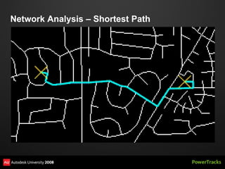
- 25. Network Analysis ŌĆō Shortest Path
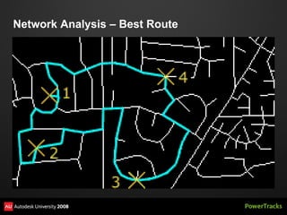
- 26. Network Analysis ŌĆō Best Route
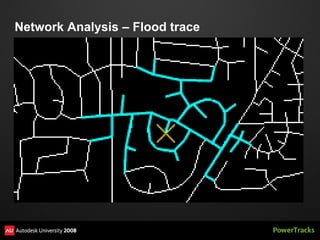
- 27. Network Analysis ŌĆō Flood trace
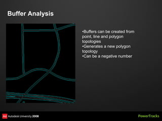
- 28. Buffer Analysis ŌĆóBuffers can be created from point, line and polygon topologies ŌĆóGenerates a new polygon topology ŌĆóCan be a negative number
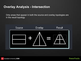
- 30. Overlay Analysis - Intersection Only areas that appear in both the source and overlay topologies are in the result topology
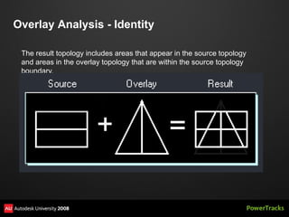
- 31. Overlay Analysis - Identity The result topology includes areas that appear in the source topology and areas in the overlay topology that are within the source topology boundary.
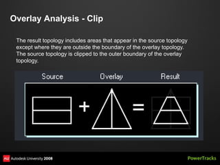
- 32. Overlay Analysis - Clip The result topology includes areas that appear in the source topology except where they are outside the boundary of the overlay topology. The source topology is clipped to the outer boundary of the overlay topology.
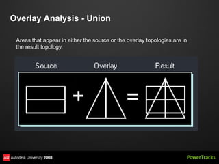
- 33. Overlay Analysis - Union Areas that appear in either the source or the overlay topologies are in the result topology.
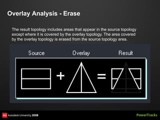
- 34. Overlay Analysis - Erase The result topology includes areas that appear in the source topology except where it is covered by the overlay topology. The area covered by the overlay topology is erased from the source topology area.
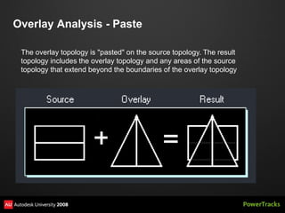
- 35. Overlay Analysis - Paste The overlay topology is "pasted" on the source topology. The result topology includes the overlay topology and any areas of the source topology that extend beyond the boundaries of the overlay topology
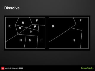
- 36. Dissolve
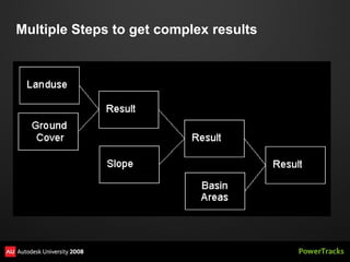
- 38. Multiple Steps to get complex results
- 40. Review Questions Topology is a synonym of topography. ’é¦ True ’é¦ False
- 41. Review Questions To find who owns the land where a new power pole is being installed, I could use a ’é¦ Polygon Intersection ’é¦ Line Buffer ’é¦ Point in Polygon ’é¦ Polygon Recode
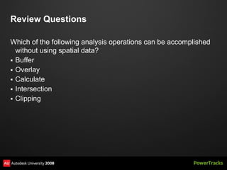
- 42. Review Questions Which of the following analysis operations can be accomplished without using spatial data? ’é¦ Buffer ’é¦ Overlay ’é¦ Calculate ’é¦ Intersection ’é¦ Clipping