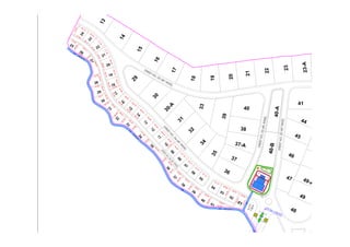
Baroha Farms map.pdf
- 1. 1 3 1 4 1 5 1 6 1 7 1 8 19 2 0 2 1 2 2 2 3 2 3 - A S T R E E T N O . 0 4 ( 4 0 ' W I D E ) S T R E E T N O . 0 3 ( 4 0 ' W ID E ) STREET NO. 05 (40' WIDE) S TR E E T N O . 0 2 (4 0 ' W ID E ) 49 49-A 50 44 45 46 41 Nallah ROW-08' N a l l a h R O W - 0 8 ' Nallah ROW -08' S . T . P 1 . 5 0 K 47 48 2 9 3 0 3 1 3 3 36 37 37-A 3 9 38 40 3 2 3 4 3 5 3 0 - A 50' 20.00 20.0 10.0 20.00 S T R E E T N O . 0 6 ( 2 5 ' W I D E ) 01 41 40 39 38 3 7 3 6 3 5 3 4 3 3 32 3 1 30 29 28 2 7 26 25 02 03 04 05 06 0 7 0 8 0 9 1 0 1 1 1 2 1 3 14 15 16 1 7 18 19 20 21 22 2 3 2 4 58.46 60.00 59.99 57.15 57.19 57.91 5 8 . 1 5 6 1 . 1 6 6 0 . 0 0 6 0 . 0 0 75.00 6 0 . 0 0 6 0 . 0 0 6 2 . 8 8 66.90 62.92 56.55 58.10 62.92 69.45 7 2 . 9 0 5 0 . 5 8 5 6 . 3 7 6 6 . 3 9 6 2 .7 3 6 2 .7 3 6 9 . 3 2 5 8 . 6 6 5 7 . 4 0 7 1 . 3 2 7 1 . 3 2 5 7 . 4 0 67.25 54.13 63.12 57.98 7 5 . 0 0 72.08 5 8 . 9 3 93.71 78.24 43.72 1 2 9 . 4 6 50.59 6 5 .4 3 75.80 5 6 . 3 7 79.01 5 3 . 3 6 60.49 7 8 . 3 9 6 8 . 6 9 58.97 6 7 . 0 5 92.79 43.82 1 1 1 . 0 6 36.24 1 4 3 . 0 3 36.23 9 5 . 0 0 62.77 6 4 . 0 4 6 8 . 9 6 69.73 5 7 . 5 5 80.23 6 3 . 4 4 63.99 6 3 . 3 9 138.97 154.92 8 7 . 7 3 1 0 3 . 4 7 7 5 . 0 0 75.00

