


More Related Content
Viewers also liked (18)
More from ce4710 (18)


Basel 3
- 1. Basel (Bahl, b├”z┬Ę╔Öl, ╦łbe╔¬┬Ęz╔Öl) By Chris Dionne, Ryan Wolpo, Mike DeJohn, Mike Disla, and Aldo Rodhani
- 2. Basel Overview -Located at the intersection of Germany, France, Switzerland -Dense population -Intermodal transportation
- 3. Judgement Principles (Jarrett Walker) 1.It takes me where I want to go 2.It takes me when I want to go 3.It is a good use of my time 4.It is a good use of my money 5.It respects me in the level of safety, comfort, and amenity it provides 6.I can trust it 7.It give me freedom to change my plans
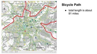
- 4. Bicycle Path ŌŚÅ total length is about 81 miles
- 10. ŌĆ£m┤Ū▓į▒▓ŌŌĆØ
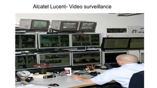
- 14. Alcatel Lucent- Video surveillance
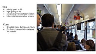
- 17. Pros ŌŚÅ priority given to PT ŌŚÅ high quality of PT ŌŚÅ sustainable transportation system ŌŚÅ Intermodal transportation system Cons ŌŚÅ Crowded trams during peak hours ŌŚÅ Confusing transportation network for tourists
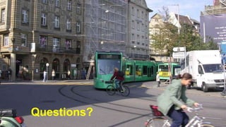
- 18. Questions?
- 19. Work Cited ŌŚÅ https://www.rhb.ch/en/leisure-travel-and-excursions/discover-graubuenden/graubuendenpass-bike ŌŚÅ http://www2.alcatel-lucent.com/enterprise-and-industries/_references/_files/pdf_sfr2.pdf ŌŚÅ http://urbact.eu/fileadmin/Projects/Egtc/documents_media/PPT_Launch_conf_Urbact.pdf ŌŚÅ http://iclrd.org/web/wp-content/uploads/2011/04/Basel-Metropolitan-Area-Three-Borders-One-Metropolitan-Area-Dec10.pdf ŌŚÅ http://www.ecf.com/wp-content/uploads/Auer-Barbara-Intermodal-Transport-Key-Factors-for-a-Successful-Cooperation____.pdf
Editor's Notes
- #3: (Ryan) Basel is a city in switzerland located on the border of France and Germany. Densely populated within the city. Things to talk aboot: Geographic location Dense population. NO SPECIFICS Presence of a downtown. Intermodal Transportation - define? maybe, if we need to fill time Focus on sustainable transportation Priority of transportation system. Fuck da automobiles.
- #4: (Ryan) We plan on using the principles proposed by Jarrett walker in his book ŌĆ£Human TransitŌĆØ as the basis for our judgement WalkerŌĆÖs method seemed best to asses the current state of a transportation system. We discussed the flaws of the three legged stool The nested box seems better used for planning rather than assessing.
- #5: ŌĆ£WhereŌĆØ (Disla) Bike Network extends into other countries and continues all the way to the airport Green lines are bike on road with light traffic Yellow lines road with heavy traffic Blue area towards the center has a ban on bicycles. red line shows border between countries Location of stops Connectivity
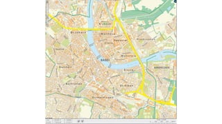
- #6: ŌĆ£WhereŌĆØ (DeJohn) - This is an overview of the street network in Basel, the yellow lines outline the major highway, - ItŌĆÖs important to note that cars do not play an important role in transportation in the city. - Other than the partial ban on cars in the center of the city, there are traffic calmed zones where the speed limit is 30 km/h (18.6 mph) in residential area, and over 60 shared zones where the pedestrians have the right of way, to improve safety for both pedestrians and cyclists. - Surrounding the city center, the streets have a grid shape making it well connected. The grid sections are split apart by various parks, farmland, and other open spaces that are spread all over the city. - Currently there are 5 bridges crossing the Rhine River, these bridges allow for pedestrian, bicycle, and automobile traffic, and some have trams that cross them. (Reference) - Schwarzwaldbr├╝cke..10 lanes (4 lanes highway), 2 footpaths - Wettsteinbr├╝cke..cars, pedestrians, tramways - Mittlere Br├╝cke.. - Johanniterbr├╝cke.. - Dreirosenbr├╝cke..
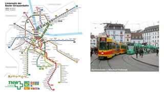
- #7: ŌĆ£WhereŌĆØ (Chris) Based on what mike said the connectivity (limited sprawl) of the street network allows for quick transfers between different modes Trams are the most prominent part approximately 48 miles of track Two main companies. BVB (Green), BLT (Yellow) Line 1 runs in a loop, which is unlike many cities which have a radial tram network, this make is much easier to get across the Rhein River (location of stops) Line runs perpendicular to radial routes, provides better access(?) Tram lines can take you around the city, into the suburbs, and into the surrounding french and german regions. Tram lines are criss crossed by bus routes that run throughout the city ŌĆ£As you can see from mikeŌĆÖs slides the street network is a gridded network with high connectivity. This physical feature of the city allows for greater access and high walkability. It also improves the effectiveness of networks for bikes, trams, and buses. As weŌĆÖve said before the tram network has approximately 48 miles of track. Tram lines in this system can bring people from the suburbs to the city center, circulate them through the city, or allow for international travel across the french and german borders. As you can see in the photo some of the lines, like the brown line, run perpendicular to radial routes which helps connect passengers to various parts of the city. The bus network also criss crosses this tram network which further connects the different areas in the city. The structure of this systems helps eliminate the need to travel first to the center and then travel back out (use photo).ŌĆØ
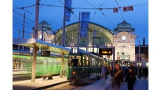
- #8: ŌĆ£W│¾▒▓įŌĆØ (DeJohn) SBB Rail station, main station in Basel Trams and buses in Basel run every 7.5 minutes on weekdays, 10 minutes on Sundays, and 15 minutes in the evenings
- #9: ŌĆ£W│¾▒▓įŌĆØ (DeJohn) Basel also offers a night tram and bus service On Fridays and Saturdays, that runs from 5:30 to Midnight, the area this network covers is located towards the center of the city (White is S-Bahn Train, Red is the Tram, And Blue is the bus network ) All good info but not needed, will only be covered by request
- #10: ŌĆ£TimeŌĆØ (Disla) The factors affecting speed of trip 1.Access time at beginning of trip ---> Walking, biking (Access time is short due to high street and bike network connectivity) 2.Wait time ---> Every 7-8 minutes (15 during the evening and 10 on sundays) 3.Number of stops ----> depends on the line 4.Dwell time at stops ---> passengers pay beforehand to reduce boarding times 5.Speed of the vehicles ---> 6.Connecting time ---> 7.Access time at end of trip ---> Walking, biking (reference street connectivity) bike stations facilities at railways are opened before the first and last train carry on bikes to transform from one transportation mode to the other
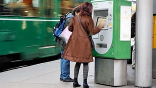
- #11: ŌĆ£MoneyŌĆØ (Chris) ŌĆ£Potential users compare transit fare to the cost of making the trip by other means. One thing that works against transit and in favor of cars is that most people do not compare apples to oranges. In other words, they compare the transit fare to the OUT-OF-POCKET cost of the trip by car (gas and, maybe, parking). ŌĆ£ ŌĆ£An important part of this system is that it allows for competition between public transit and private automobile ownership. As we have stated in previous presentations, the TNW controls the pricing of tickets and allows for the coordination of schedules between the companies that run the bus and tram services. This means that one ticket gets you access to all transportation modes the city has to offer as well as the ability to travel anywhere within the TNW area. The benefit of this system is that it allows citizens and visitors to easily compare the out of pocket cost of public transit to the costs associated with car ownership such as insurance, gas, maintenance and parking. There are many types of tickets available for purchase from single trips to yearly subscriptions which allows the user flexibility in out of pocket costs for travel.ŌĆØ
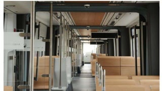
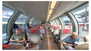
- #12: ŌĆ£RespectŌĆØ (Aldo) 1.Comfort ---> high quality on public transport, brand new trams. 2.Courtesy ---> wifi, air conditioning, very clean ambient in the transportation modes and around the stations, punctual system 3.Safety ---> Safe railway station surroundings because of their tidiness. Introduction of reduced-traffic areas (30 km/h = 18 miles/h), 66 bicycle accidents for 2012 compare to over 200 accidents in 2005. 4.Security ---> IP based video surveillance which offers objective and subjective security to passengers and station costumers. Camera Surveillance. Biking parking facilities offer protection from theft and damage.
- #14: ŌĆ£TrustŌĆØ (Aldo) Three main factors here include 1.Reliability---> Very reliable transportation. cyclists feel that they are taken seriously. Video surveillance 2.RedundancyŌåÆ 3.Frequency ŌåÆ 7/7 almost 24/24
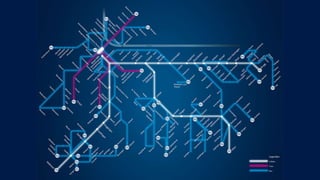
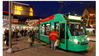
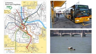
- #16: Freedom (DeJohn) This is a map of the tram and bus network over the city, there are many stops and routes all over the city that donŌĆÖt only run directly into the center but also around the city, as mentioned earlier with the tram, but notice the bus routes also do the same all around the. There are also buses that run directly from the train station to the airport located in France, and itŌĆÖs one of the only cities that has trams that cross the border into other countries daily. Along with the 5 bridges I mentioned earlier, Basel has 4 ferries located at the midpoint between the bridges, which use the current of the river to cross. (Reference) The main factors in freedom (to change plans) include 1.Span of service- With the night network running from 5:30-midnight on Fri. and Sat. 2.Frequency of service- Never have to wait more than 15 minutes at any time of day 3.Coverage and connection of service- the tram network and the bus network show that there is extensive coverage, and easy access to other countries and airport. 4.Good average speed 5.Legibility of service
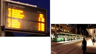
- #17: ŌĆ£FreedomŌĆØ (DeJohn) On the platforms for the trams and buses, the city has these digital signs that display the: Line // Destination // Departure TimeŌĆ”.of the next bus or tram these signs are always updating making the wait seem shorter because you know when the tram is coming, and make changing your plans very easy
- #18: (Ryan)