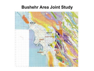
Bushehr Joint Study Blocks
- 1. SE Binak Lead âAâ Kutah Asan Buzpar (Helleh) Gisakan Char Pir (Leads âBâ&âCâ) (Bushehr) Bushehr Area Joint Study
- 2. I. AGHA JARI MISHAN GACHSARAN I. GACHSARAN ASMARI SARVAK DARIYAN NEYRIZ Line 78327A migration Datum 1600m ASL NE>Southeast Binak Line 78302 migration Datum 1600m ASL SE BINAK
- 3. SE Binak Lead â Top Asmari Depth Map 0.584 TCFGas 363 MMbblsOilPossible Volumes in place: Por=7%; Sw=20%; N:G=80% 1,416.17623.629-3,500-5,100 540.41712.269-3,450-5,050 112.4404.862-3,400-5,000 0.0020.007-3,350-4,950 0.0000.000-3,349-4,949 Gross Rock Volume (MM cu. m.) Area (sq. km.) Depth (mss) Depth (1,600 masl) N Length: 9.2 km Width: 4.0 km Vertical closure: 151 m
- 4. Lead A Line R-367 stack Datum 1600m ASL I. AGHA JARI MISHAN GACHSARAN I. GACHSARAN ASMARI SARVAK DARIYAN NEYRIZ NE> NARGESI TREND SURFACE LEAD A
- 5. Lead âAâ â Top Neyriz Depth Map N Length: 20.4 km Width: 8.4 km Vertical closure: 353 m 7.347 TCFGas 3,086 MMbblsOilPossible Volumes in place: Por=5%; Sw=20%; N:G=80% 16,863.332120.143-6,200-7,800 16,270.56596.476-6,150-7,750 14,634.78574.741-6,100-7,700 11,798.43352.353-6,050-7,650 7,655.84028.520-6,000-7,600 5,104.50817.171-5,950-7,550 2,470.3607.596-5,900-7,500 119.3200.339-5,850-7,450 0.0000.000-5,847-7,447 Gross Rock Volume (MM cu. m.) Area (sq. km.) Depth (mss) Depth (1,600 masl)
- 6. Gisakan â Topography, Surface Geology and Seismic Coverage
- 7. INTRA AGHA JARI MISHAN GACHSARAN INTRA GACHSARAN ASMARI SARVAK DARIYAN NEYRIZ E>Lead C and B Line 78322 migration Datum 1600m ASL LEAD C LEAD B
- 8. Leads âB & Câ â Top Sarvak Depth Map Perspectives N Kutah Lead âAâ Leads âB&Câ
- 9. Leads âB & Câ â Top Sarvak Depth Map Perspectives N
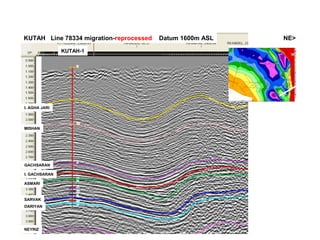
- 10. KUTAH Line 78334 migration-reprocessed Datum 1600m ASL I. AGHA JARI MISHAN GACHSARAN I. GACHSARAN ASMARI SARVAK DARIYAN NEYRIZ NE> KUTAH-1
- 11. Kutah â Top Sarvak Depth Map Perspectives Kutah Kutah-1 N
- 12. Seismic Reprocessing â overlay on Asmari depth Kesht/Gisakan detailing SE Binak â Lead âAâ â Kesht ties Lead âAâ detailing SE Binak detailing Helleh detailing Structural detail Total to reprocess = 491 km (409 km onshore + 82 km offshore)
- 15. Maturation Modelling Binak Helleh Char Pir Khurmuj Sea Level Maturity zones schematic only Immature for hydrocarbon generation? Mature for significant oil generation? Mature for mainly gas generation? Useful gases for soft-drinks and global warming?
- 16. Basin Modelling & Prospect Ranking Structural models Maturation & migration models Reservoir & seal models Seismic interpretation RANKING OF LEADS & PROSPECTS


