Cratp
ŌĆóDownload as PPT, PDFŌĆó
0 likesŌĆó371 views

The document discusses community risk assessment tools and processes. It explains that community risk assessment is a methodology used to determine hazards, vulnerabilities, and risks within a community. It involves analyzing potential hazards, existing vulnerabilities, and evaluating coping capacities for likely risk scenarios. The document also outlines the risk assessment process, which includes identifying hazards and at-risk areas, profiling affected residents, and designating evacuation sites. Hazard maps and recent weather data are presented. The importance of risk assessment is that it enables communities to better prepare and respond to disasters to reduce impacts on health, life and property.

Cratp
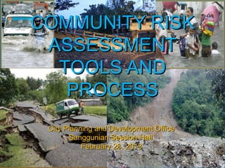
- 1. COMMUNITY RISKCOMMUNITY RISK ASSESSMENTASSESSMENT TOOLS ANDTOOLS AND PROCESSPROCESS City Planning and Development OfficeCity Planning and Development Office Sanggunian Session HallSanggunian Session Hall February 28, 2013February 28, 2013
- 2. REPUBLIC ACT NO. 10121REPUBLIC ACT NO. 10121 AN ACT STRENGTHENING THE PHILIPPINEAN ACT STRENGTHENING THE PHILIPPINE DISASTER RISK REDUCTION ANDDISASTER RISK REDUCTION AND MANAGEMENT SYSTEM, PROVIDING FOR THEMANAGEMENT SYSTEM, PROVIDING FOR THE NATIONAL DISASTER RISK REDUCTION ANDNATIONAL DISASTER RISK REDUCTION AND MANAGEMENT FRAMEWORK ANDMANAGEMENT FRAMEWORK AND INSTITUTIONALIZING THE NATIONAL DISASTERINSTITUTIONALIZING THE NATIONAL DISASTER RISK REDUCTION AND MANAGEMENT PLAN,RISK REDUCTION AND MANAGEMENT PLAN, APPROPRIATING FUNDS THEREFORAPPROPRIATING FUNDS THEREFOR AND FOR OTHER PURPOSESAND FOR OTHER PURPOSES
- 3. WHAT IS COMMUNITY RISKWHAT IS COMMUNITY RISK ASSESTMENT?ASSESTMENT? a methodology to determine the nature anda methodology to determine the nature and extent of risk within the community by analyzingextent of risk within the community by analyzing potential hazards and evaluating existingpotential hazards and evaluating existing conditions of vulnerability that together couldconditions of vulnerability that together could potentially harm exposed people, property,potentially harm exposed people, property, services, livelihood and the environment on whichservices, livelihood and the environment on which they depend. Risk assessments with associatedthey depend. Risk assessments with associated risk mapping include: a review of the technicalrisk mapping include: a review of the technical characteristics of hazards such as their location,characteristics of hazards such as their location, intensity, frequency and probability; the analysisintensity, frequency and probability; the analysis of exposure and vulnerability including theof exposure and vulnerability including the physical, social, health, economic andphysical, social, health, economic and environmental dimensions; and the evaluation ofenvironmental dimensions; and the evaluation of the effectiveness of prevailing and alternativethe effectiveness of prevailing and alternative coping capacities in respect to likely riskcoping capacities in respect to likely risk scenarios.scenarios.
- 4. WHY DO WE NEED COMMUNITYWHY DO WE NEED COMMUNITY RISK ASSESTMENT?RISK ASSESTMENT? Community disaster risk assessmentCommunity disaster risk assessment will be our main tool in formulatingwill be our main tool in formulating plans that will help us in responseplans that will help us in response and recovery when disaster occursand recovery when disaster occurs and may help us return to a normaland may help us return to a normal or near-normal living with a minimalor near-normal living with a minimal impact for a quick recovery of theimpact for a quick recovery of the community.community.
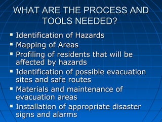
- 5. WHAT ARE THE PROCESS ANDWHAT ARE THE PROCESS AND TOOLS NEEDED?TOOLS NEEDED? ’ü« Identification of HazardsIdentification of Hazards ’ü« Mapping of AreasMapping of Areas ’ü« Profiling of residents that will beProfiling of residents that will be affected by hazardsaffected by hazards ’ü« Identification of possible evacuationIdentification of possible evacuation sites and safe routessites and safe routes ’ü« Materials and maintenance ofMaterials and maintenance of evacuation areasevacuation areas ’ü« Installation of appropriate disasterInstallation of appropriate disaster signs and alarmssigns and alarms
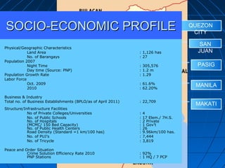
- 6. QUEZON CITY SAN JUAN MANILA PASIG MAKATI Physical/Geographic Characteristics Land Area : 1,126 has No. of Barangays : 27 Population 2007 Night Time : 305,576 Day time (Source: PNP) : 1.2 m Population Growth Rate : 1.29 Labor Force Oct. 2009 : 61.6% 2010 : 62.20% Business & Industry Total no. of Business Establishments (BPLO/as of April 2011) : 22,709 Structure/Infrastructure Facilities No of Private Colleges/Universities : 4 No. of Public Schools : 17 Elem./ 7H.S. No. of Hospitals : 2 Private (MCMC/ 150 Bed Capacity) : 1 GovŌĆÖt No. of Public Health Centers : 26 Road Density (Standard =1 km/100 has) : 9.96km/100 has. No. of PUJŌĆÖs : 7,444 No. of Tricycle : 3,819 Peace and Order Situation Crime Solution Efficiency Rate 2010 : 92% PNP Stations : 1 HQ / 7 PCP SOCIO-ECONOMIC PROFILESOCIO-ECONOMIC PROFILE
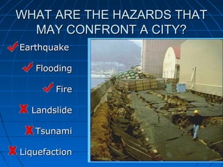
- 7. WHAT ARE THE HAZARDS THATWHAT ARE THE HAZARDS THAT MAY CONFRONT A CITY?MAY CONFRONT A CITY? EarthquakeEarthquake FloodingFlooding FireFire LandslideLandslide TsunamiTsunami LiquefactionLiquefaction
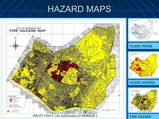
- 8. HAZARD MAPSHAZARD MAPS FIRE HAZARD FLOOD PRONE FLOOD HAZARD
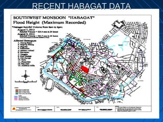
- 9. RECENT HABAGAT DATARECENT HABAGAT DATA
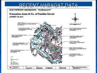
- 10. RECENT HABAGAT DATARECENT HABAGAT DATA
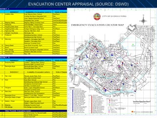
- 11. EVACUATION CENTER APPRAISAL (SOURCE: DSWD)EVACUATION CENTER APPRAISAL (SOURCE: DSWD)
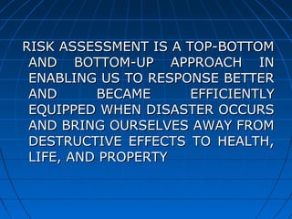
- 12. RISK ASSESSMENT IS A TOP-BOTTOMRISK ASSESSMENT IS A TOP-BOTTOM AND BOTTOM-UP APPROACH INAND BOTTOM-UP APPROACH IN ENABLING US TO RESPONSE BETTERENABLING US TO RESPONSE BETTER AND BECAME EFFICIENTLYAND BECAME EFFICIENTLY EQUIPPED WHEN DISASTER OCCURSEQUIPPED WHEN DISASTER OCCURS AND BRING OURSELVES AWAY FROMAND BRING OURSELVES AWAY FROM DESTRUCTIVE EFFECTS TO HEALTH,DESTRUCTIVE EFFECTS TO HEALTH, LIFE, AND PROPERTYLIFE, AND PROPERTY