1. Definition and uses of leveling
?Leveling is a type of surveying which is carried out for measuring the elevation of ground
points or near to it and to establish the elevation or heights of ground points which are vital
for engineering design
The elevation of points or heights of points is defined as its vertical distance above or below
a given reference, Level surface, Datum.
Leveling results are used to:
1. Design high ways, railways & canals having grade lines that best conform to the existing
topography
2. Layout construction works or projects according to planned elevations.
3. Calculate volumes of earth work.
4. Investigate drainage characteristics of an area.
5. Develop maps showing general ground configuration.
6. Determine the height (altitude) of the ground at a number of points along any desired
lines so that sections may be drown.
7. To set out level or horizontal surface such as floor slabs, foundation trenches and machine
bases etc
2. Types of leveling instrument
?Leveling is the term used for determining the height or difference in height above the
ground form a horizontal reference surface.
?The instrument used for leveling is called a' level.
? Leveling instruments can be classified under three categories, i.e
1. Dumpy level:-the line of sight is perpendicular to the vertical axes
2. Tilting level,:- The telescope is not rigidly attached with the tribrach as the dumpy level
3. Automatic level:- is leveled automatically by means of a compositor which ensures that
the line of sight viewed, through the telescope is horizontal
?it can be leveled with in assort period of time and shows an erect image through the
telescope.
4. Digital level
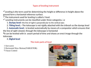
The main parts of level
1 foot screw
2 Horizontal Slow Motion(TARGETOR)
?3 focus Control
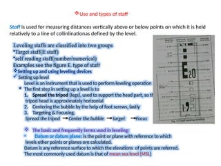
3. ?Use and types of staff
Staff is used for measuring distances vertically above or below points on which it is held
relatively to a line of collinlinationas defined by the level.
Leveling staffs are classified into two groups
?Target staff(E staff)
?self reading staff(number/numerical)
Examples see the figure E. type of staff
?Setting up and using leveling devices
? Setting up level
Level is an instrument that is used to perform leveling operation
? The first step in setting up a level is to
1. Spread the tripod (legs), used to support the head part, so that the
tripod head is approximately horizontal
2. Centering the bubble by the help of foot screws, lastly
3. Targeting & Focusing.
Spread the tripod Center the bubble target Focus
? The basic and frequently terms used in leveling:
? Datum or datum plane: is the point or plane with reference to which
levels other points or planes ore calculated.
Datum is any reference surface to which the elevations of points are referred.
The most commonly used datum is that of mean sea level (MSL)
4. ? Reduced level (R.L) the levels of various points takes 0$ heights above the surface or it is a
height of points stated with reference to the selected dot the work in hand.
It is height above or below reference datum.
ContĪŁ
?Level surface:- a curved surface that at every point is perpendicular to the plumb line (the
direction of gravity)
? Horizontal surface: - is any surface that is tangential to the level surface at given point & is
perpendicular to the vertical line.
? Horizontal line: - is a line in a horizontal plane or surface perpendicular to t~ vertical line.
? Vertical line: - is a line that follows the direction of gravity/plumb line.
? Elevation: - is the vertical distance from a datum to a point.
? Instrument station: - is the place where the instrument is set up for observe.
? Leveling rod (leveling staff) is a measuring instrument that is graduated for vertical
measurement.
? Staff station: - is the point where a leveling staff is held vertically for taken readings.
? Height of collimation (H. C)- is the vertical distance from the datum to the line sight of the
instrument
? Back sight (B.S) - is a staff reading taken on a point after the instrument is immediately set
up.
? Fore sight (F.S):- is the last reading or sight taken during leveling before the instrument is
moved.
5. CONTĪŁ
? Turning point (changing point) - (T.P or C.P) - is the station or point where both fore sight
&Back sight readings are taken it denotes the shifting of the instrument.
? Bench mark (B.M):- is a relative permanent & fixed reference point of known elevation
& after Elevation are determined from it. Permanent point of known elevation.
?There are four types of bench mark(B.M)
1. Temporary/transferred (TBM):- mark set up on stable points near construction
2. Arbitrary bench mark(ABM)
3. Permanent bench mark(PBM)
4. Great trigonometrical survey )
Note- leveling: - the process of determining of the elevation of points.
Level: ~ is the instrument used to take readings for elevation
?Some of the methods of leveling are
? Direct or Simple Leveling
? Differential leveling :- most efficiently performed by a party of five, viz.: an observer or
instrument man, an umbrella man, a note keeper and two staff men
? Profile leveling:- is the process of determining the elevations of points at short measured
intervals along a fixed line such as the center line of railway, highway, canal or sewer.
? Cross - section leveling
? Trigonometric leveling:- Used to measure vertical angle by theodolite instrument.
? Reciprocal leveling:- In carrying levels across deep valleys and across streams, it is
frequently impossible to keep the fore sight and back sight distances equal
? Barometric leveling