際際滷

際際滷Share a Scribd company logo
DELPH Mag
 General Presentation
           V2.9
        Spring 2012
2
     Introduction

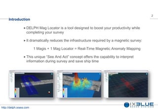
                  DELPH   Mag Locator is a tool designed to boost your productivity while
                   completing your survey

                  It    dramatically reduces the infrastructure required by a magnetic survey:

                           1 Magis + 1 Mag Locator = Real-Time Magnetic Anomaly Mapping

                  This unique See And Act concept offers the capability to interpret
                   information during survey and save ship time


http://delph.ixsea.com
3
     DELPH Mag Locator Components


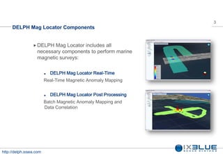
                  DELPH  Mag Locator includes all
                   necessary components to perform marine
                   magnetic surveys:

                            DELPH Mag Locator Real-Time
                         Real-Time Magnetic Anomaly Mapping


                            DELPH Mag Locator Post Processing
                         Batch Magnetic Anomaly Mapping and
                         Data Correlation


http://delph.ixsea.com
4
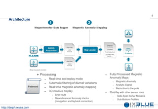
     Architecture


                            Processing                                            Fully Processed Magnetic
                                   Real time and replay mode                       Anomaly Maps
                                                                                          Magnetic Anomaly
                                    Automatic filtering of diurnal variations
                                                                                      
                                
                                                                                         Analytic Signal
                     Patented      Real time magnetic anomaly mapping                   Reduction to the pole
                                   3D intuitive display                           Overlay with other sensor data
                                         Ship route                                  o    Side-Scan Sonar Mosaics
                                         Georeferenced Anomaly Vector                o    Sub-Bottom Profiles
                                          (navigation and layback correction)

http://delph.ixsea.com
5
     DELPH Mag Locator


http://delph.ixsea.com
6
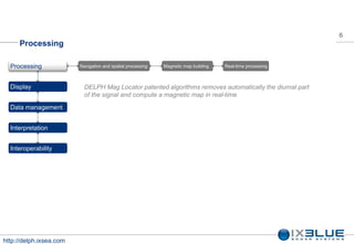
     Processing

  Processing             Navigation and spatial processing   Magnetic map building   Real-time processing


  Display                  DELPH Mag Locator patented algorithms removes automatically the diurnal part
                           of the signal and compute a magnetic map in real-time
  Data management


  Interpretation


  Interoperability


http://delph.ixsea.com
7
         Navigation and Spatial processing

                                 Firststage of the DELPH Mag Locator
   Processing
      Navigation and spatial     processing. Data is georeferenced by
   
       processing
       Magnetic map building
                                  taking into account:
      Real-time processing              Intrumental lag
                                         Cable length
                                         Winch to Gps offset
  Display

                                 Second stage removes the diurnal
  Data management                 component of the magnetic signal using
                                  one method of:
  Interpretation                         IXSEA spatial filter
                                         One shore reference station log (radio
                                          transmitted in real time)
  Interoperability


http://delph.ixsea.com
8
         Magnetic map building

                                 DELPH   Mag Locator helps you to
   Processing
      Navigation and spatial    produce magnetic maps in a
   
       processing
       Magnetic map building
                                 really simple way:
      Real-time processing          Define the 3 gridding parameters
                                     Define the auxiliary maps
                                      needed (reduction to the pole,
  Display                             analytic signal)
                                     Define the output filename
  Data management                    Click on the Process button
                                     Your map is available few
                                      seconds later
  Interpretation


  Interoperability


http://delph.ixsea.com
9
         Realtime processing

                                 DELPH Mag Locator is fully integrated with
   Processing
      Navigation and spatial    the IXSEA Magis magnetometer data
   
       processing
       Magnetic map building
                                 logger
      Real-time processing

                                 Magneticmaps are computed in real-time
  Display
                                 using IXSEA patented algorithms

                                 DELPH   Mag Locator helps you to lead your
  Data management
                                 magnetic survey with reactivity and
                                 efficiency. It hides complexity giving you
  Interpretation                 simplicity: You can focus on your survey

  Interoperability


http://delph.ixsea.com
10
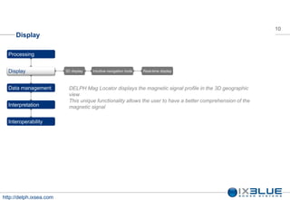
     Display

  Processing


  Display                3D display   Intuitive navigation tools   Real-time display


  Data management          DELPH Mag Locator displays the magnetic signal profile in the 3D geographic
                           view
                           This unique functionality allows the user to have a better comprehension of the
  Interpretation           magnetic signal

  Interoperability


http://delph.ixsea.com
11
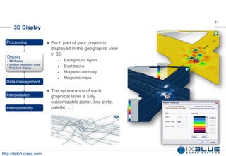
          3D Display

  Processing                        Each part of your project is
                                    displayed in the geographic view
                                    in 3D
  Display
     3D display                           Background layers
  
  
      Intuitive navigation tools
      Real-time display
                                           Boat tracks
                                           Magnetic anomaly
                                           Magnetic maps
  Data management

                                    Theappearance of each
  Interpretation                    graphical layer is fully
                                    customizable (color, line style,
  Interoperability                  palette, )


http://delph.ixsea.com
12
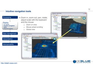
         Intuitive navigation tools

  Processing                  Zoom  in, zoom out, pan, rotate,
                              adjust scale with the keyboard
  Display                     and the mouse
     3D display                     Zoom on area
     Intuitive navigation
      tools                          Mouse wheel scrolling
     Real-time display
                                     Global view

  Data management


  Interpretation


  Interoperability


http://delph.ixsea.com
13   13
        Real-time display

  Processing                        Real-time  mapping provides See
                                    and Act capability not possible with
                                    traditional methods
  Display
     3D display
     Intuitive navigation tools
     Real-time display


  Data management


  Interpretation


  Interoperability


http://delph.ixsea.com
14
     Data management

  Processing
                         You can group your survey data file into a DELPH RoadMap project and then use
  Display                Mag Locator functionalities from a unique tool


  Data management        Organize and manage data files   Mag Locator integration


  Interpretation


  Interoperability


http://delph.ixsea.com
15
         Organize and manage data files

  Processing                     WithDELPH RoadMap you can
                                 load multiple lines, define
  Display                        geodesy, add some background
                                 layers and then store all your
                                 work in a RoadMap project that
  Data management                you can reload later
     Organize and manage
      data files
     Mag Locator integration
                                 The project is organized in a
                                 structured way
  Interpretation

                                 Each item of the project is
  Interoperability               configurable through a property
                                 sheet


http://delph.ixsea.com
16
        DELPH Mag Locator integration

  Processing                     DELPH RoadMap is especially
                                 designed to work in conjunction
  Display                        with DELPH Mag Locator

                                 Once a data file has been loaded
  Data management
     Organize and manage        into DELPH RoadMap you can
  
      data files
      Mag Locator integration
                                 process it using DELPH Mag
                                 Locator

  Interpretation
                                 Magnetic map generation can be
                                 activated from DELPH RoadMap
  Interoperability


http://delph.ixsea.com
17
     Interpretation

  Processing


  Display
                         You can group your survey data file into a DELPH RoadMap project and then use
                         Mag Locator functionalities from a unique tool
  Data management


  Interpretation         Measurement tools   Multi-sensor correlation


  Interoperability


http://delph.ixsea.com
18
         Measurement tool

  Processing                      Use the measurement tool
                                  to obtain the length of map
  Display                         features


  Data management                 DELPH RoadMap helps you
                                  to measure a single
                                  segment or a complete path
  Interpretation
     Measurement tools
     Multi-sensor correlation


  Interoperability


http://delph.ixsea.com
19
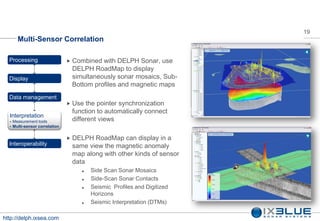
        Multi-Sensor Correlation

  Processing                      Combined with DELPH Sonar, use
                                  DELPH RoadMap to display
  Display                         simultaneously sonar mosaics, Sub-
                                  Bottom profiles and magnetic maps
  Data management
                                  Use the pointer synchronization
                                  function to automatically connect
  Interpretation
     Measurement tools           different views
     Multi-sensor correlation


                                  DELPH RoadMap can display in a
  Interoperability                same view the magnetic anomaly
                                  map along with other kinds of sensor
                                  data
                                        Side Scan Sonar Mosaics
                                        Side-Scan Sonar Contacts
                                        Seismic Profiles and Digitized
                                         Horizons
                                        Seismic Interpretation (DTMs)

http://delph.ixsea.com
20
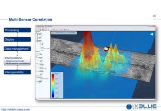
        Multi-Sensor Correlation

  Processing


  Display


  Data management


  Interpretation
     Measurement tools
     Multi-sensor correlation


  Interoperability


http://delph.ixsea.com
21
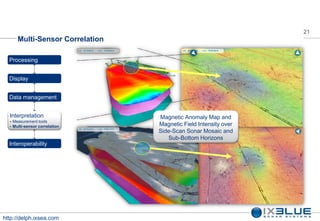
        Multi-Sensor Correlation

  Processing


  Display


  Data management


  Interpretation                   Magnetic Anomaly Map and
                                   Magnetic Field Intensity over
     Measurement tools
     Multi-sensor correlation
                                   Side-Scan Sonar Mosaic and
                                      Sub-Bottom Horizons
  Interoperability


http://delph.ixsea.com
22
      Interoperability - Export

  Processing              The on screen image can be
                          exported (with or without overlaid
  Display                 information) to geoTIFF or
                          bitmap image
  Data management
                          The resulting image can be
                          directly incorporated in your
  Interpretation
                          report

  Interoperability
                          Magnetic data can be converted
                          into raw text file to be post-
                          processed with third party
                          software

                          Maps can be converted to
                          various file formats (FLT, XY哦)


http://delph.ixsea.com
Questions ?
  Thank you.

More Related Content

Delph v29 3 - DELPH Mag

  • 1. DELPH Mag General Presentation V2.9 Spring 2012
  • 2. 2 Introduction DELPH Mag Locator is a tool designed to boost your productivity while completing your survey It dramatically reduces the infrastructure required by a magnetic survey: 1 Magis + 1 Mag Locator = Real-Time Magnetic Anomaly Mapping This unique See And Act concept offers the capability to interpret information during survey and save ship time http://delph.ixsea.com
  • 3. 3 DELPH Mag Locator Components DELPH Mag Locator includes all necessary components to perform marine magnetic surveys: DELPH Mag Locator Real-Time Real-Time Magnetic Anomaly Mapping DELPH Mag Locator Post Processing Batch Magnetic Anomaly Mapping and Data Correlation http://delph.ixsea.com
  • 4. 4 Architecture Processing Fully Processed Magnetic Real time and replay mode Anomaly Maps Magnetic Anomaly Automatic filtering of diurnal variations Analytic Signal Patented Real time magnetic anomaly mapping Reduction to the pole 3D intuitive display Overlay with other sensor data Ship route o Side-Scan Sonar Mosaics Georeferenced Anomaly Vector o Sub-Bottom Profiles (navigation and layback correction) http://delph.ixsea.com
  • 5. 5 DELPH Mag Locator http://delph.ixsea.com
  • 6. 6 Processing Processing Navigation and spatial processing Magnetic map building Real-time processing Display DELPH Mag Locator patented algorithms removes automatically the diurnal part of the signal and compute a magnetic map in real-time Data management Interpretation Interoperability http://delph.ixsea.com
  • 7. 7 Navigation and Spatial processing Firststage of the DELPH Mag Locator Processing Navigation and spatial processing. Data is georeferenced by processing Magnetic map building taking into account: Real-time processing Intrumental lag Cable length Winch to Gps offset Display Second stage removes the diurnal Data management component of the magnetic signal using one method of: Interpretation IXSEA spatial filter One shore reference station log (radio transmitted in real time) Interoperability http://delph.ixsea.com
  • 8. 8 Magnetic map building DELPH Mag Locator helps you to Processing Navigation and spatial produce magnetic maps in a processing Magnetic map building really simple way: Real-time processing Define the 3 gridding parameters Define the auxiliary maps needed (reduction to the pole, Display analytic signal) Define the output filename Data management Click on the Process button Your map is available few seconds later Interpretation Interoperability http://delph.ixsea.com
  • 9. 9 Realtime processing DELPH Mag Locator is fully integrated with Processing Navigation and spatial the IXSEA Magis magnetometer data processing Magnetic map building logger Real-time processing Magneticmaps are computed in real-time Display using IXSEA patented algorithms DELPH Mag Locator helps you to lead your Data management magnetic survey with reactivity and efficiency. It hides complexity giving you Interpretation simplicity: You can focus on your survey Interoperability http://delph.ixsea.com
  • 10. 10 Display Processing Display 3D display Intuitive navigation tools Real-time display Data management DELPH Mag Locator displays the magnetic signal profile in the 3D geographic view This unique functionality allows the user to have a better comprehension of the Interpretation magnetic signal Interoperability http://delph.ixsea.com
  • 11. 11 3D Display Processing Each part of your project is displayed in the geographic view in 3D Display 3D display Background layers Intuitive navigation tools Real-time display Boat tracks Magnetic anomaly Magnetic maps Data management Theappearance of each Interpretation graphical layer is fully customizable (color, line style, Interoperability palette, ) http://delph.ixsea.com
  • 12. 12 Intuitive navigation tools Processing Zoom in, zoom out, pan, rotate, adjust scale with the keyboard Display and the mouse 3D display Zoom on area Intuitive navigation tools Mouse wheel scrolling Real-time display Global view Data management Interpretation Interoperability http://delph.ixsea.com
  • 13. 13 13 Real-time display Processing Real-time mapping provides See and Act capability not possible with traditional methods Display 3D display Intuitive navigation tools Real-time display Data management Interpretation Interoperability http://delph.ixsea.com
  • 14. 14 Data management Processing You can group your survey data file into a DELPH RoadMap project and then use Display Mag Locator functionalities from a unique tool Data management Organize and manage data files Mag Locator integration Interpretation Interoperability http://delph.ixsea.com
  • 15. 15 Organize and manage data files Processing WithDELPH RoadMap you can load multiple lines, define Display geodesy, add some background layers and then store all your work in a RoadMap project that Data management you can reload later Organize and manage data files Mag Locator integration The project is organized in a structured way Interpretation Each item of the project is Interoperability configurable through a property sheet http://delph.ixsea.com
  • 16. 16 DELPH Mag Locator integration Processing DELPH RoadMap is especially designed to work in conjunction Display with DELPH Mag Locator Once a data file has been loaded Data management Organize and manage into DELPH RoadMap you can data files Mag Locator integration process it using DELPH Mag Locator Interpretation Magnetic map generation can be activated from DELPH RoadMap Interoperability http://delph.ixsea.com
  • 17. 17 Interpretation Processing Display You can group your survey data file into a DELPH RoadMap project and then use Mag Locator functionalities from a unique tool Data management Interpretation Measurement tools Multi-sensor correlation Interoperability http://delph.ixsea.com
  • 18. 18 Measurement tool Processing Use the measurement tool to obtain the length of map Display features Data management DELPH RoadMap helps you to measure a single segment or a complete path Interpretation Measurement tools Multi-sensor correlation Interoperability http://delph.ixsea.com
  • 19. 19 Multi-Sensor Correlation Processing Combined with DELPH Sonar, use DELPH RoadMap to display Display simultaneously sonar mosaics, Sub- Bottom profiles and magnetic maps Data management Use the pointer synchronization function to automatically connect Interpretation Measurement tools different views Multi-sensor correlation DELPH RoadMap can display in a Interoperability same view the magnetic anomaly map along with other kinds of sensor data Side Scan Sonar Mosaics Side-Scan Sonar Contacts Seismic Profiles and Digitized Horizons Seismic Interpretation (DTMs) http://delph.ixsea.com
  • 20. 20 Multi-Sensor Correlation Processing Display Data management Interpretation Measurement tools Multi-sensor correlation Interoperability http://delph.ixsea.com
  • 21. 21 Multi-Sensor Correlation Processing Display Data management Interpretation Magnetic Anomaly Map and Magnetic Field Intensity over Measurement tools Multi-sensor correlation Side-Scan Sonar Mosaic and Sub-Bottom Horizons Interoperability http://delph.ixsea.com
  • 22. 22 Interoperability - Export Processing The on screen image can be exported (with or without overlaid Display information) to geoTIFF or bitmap image Data management The resulting image can be directly incorporated in your Interpretation report Interoperability Magnetic data can be converted into raw text file to be post- processed with third party software Maps can be converted to various file formats (FLT, XY哦) http://delph.ixsea.com
  • 23. Questions ? Thank you.