Department Of Field And Data Management
Download as ppt, pdf1 like446 views

The document outlines the responsibilities and organizational structure of the county assessor's department, including the transition to a unified system under the elected county assessor in 2009. It emphasizes the department's commitment to accurate data management, effective customer service, and ongoing staff training to meet legislative changes and improve taxpayer support. Additionally, it details the department's diverse staff qualifications, technological tools used in assessment, and the current workload challenges associated with a growing number of parcels.


Department Of Field And Data Management
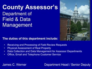
- 1. County AssessorÔÇÖs Department of Field & Data Management Receiving and Processing of Field Review Requests Physical Assessment of Real Property Data Collection and Data Management for Assessor Departments Office, Email and Telephone Customer Service The duties of this department include: James C. Werner Department Head / Senior Deputy
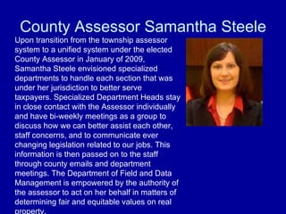
- 2. County Assessor Samantha Steele Upon transition from the township assessor system to a unified system under the elected County Assessor in January of 2009, Samantha Steele envisioned specialized departments to handle each section that was under her jurisdiction to better serve taxpayers. Specialized Department Heads stay in close contact with the Assessor individually and have bi-weekly meetings as a group to discuss how we can better assist each other, staff concerns, and to communicate ever changing legislation related to our jobs. This information is then passed on to the staff through county emails and department meetings. The Department of Field and Data Management is empowered by the authority of the assessor to act on her behalf in matters of determining fair and equitable values on real property.
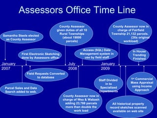
- 3. Assessors Office Time Line January 2007 Samantha Steele elected as County Assessor Parcel Sales and Data Search added to web. First Electronic Sketching done by Assessors office. Field Requests Converted to database County Assessor given duties of all 10 Rural Townships (about 19000 parcels) County Assessor now in charge of Wea & Wabash adding 23,788 parcels more than double the work load July 2008 Access (SQL) Data Management system in use by field staff January 2009 County Assessor now in charge of Fairfield Township 21,132 parcels. (3Xs original workload) All historical property record sketches scanned available on web site In House Trending Finished 1 st Commercial Mass Appraisal using Income Approach Staff Divided in to Specialized Departments
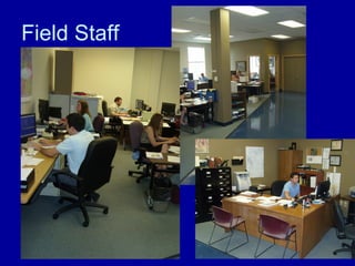
- 4. Field Staff
- 5. Office Demographics Our office staff comes from a variety of different backgrounds. They have different work experiences, education types, and political leanings. We have cultural and generational diversity and currently at least one Spanish speaking assessor. We have individuals with general practical experience such as customer service and data entry as well as specialized experience with construction, surveying, residential appraisal, real estate sales, and mortgage origination. Educationally, we have staff with Masters, Bachelors, and Associate Degrees in both technical and creative areas of emphasis, as well as professional licenses and certifications in addition to required state assessor certifications. Practical Experience Science and Technology Liberal Arts
- 6. Department Head James C. Werner Qualifications and Work History MA Purdue University, BFA American Academy Level II Assessor Prior Manager at United Parcels Service & Branch Manager for National Mortgage Banker United States Marine Corp Non Commissioned Officer Background in technical Drawing and Architecture College Professor (Ivy Tech, Purdue, American Academy) Real Estate Investor / Business Owner Association of Indiana County Assessors International Association of Assessing Officers Professional Memberships
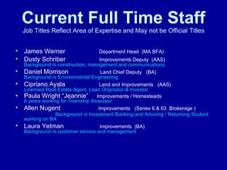
- 7. Current Full Time Staff Job Titles Reflect Area of Expertise and May not be Official Titles James Werner Department Head (MA BFA) Dusty Schriber Improvements Deputy (AAS) Background in construction, management and communications. Daniel Morrison Land Chief Deputy (BA) Background in Environmental Engineering Cipriano Ayala Land and Improvements (AAS) Licensed Real Estate Agent, Loan Originator & Investor Paula Wright ÔÇ£JeannieÔÇØ Improvements / Homesteads 6 years working for Township Assessor Allen Nugent Improvements (Series 6 & 63 Brokerage ) Background in Investment Banking and Advising / Returning Student working on BA Laura Yetman Improvements (BA) Background in customer service and management
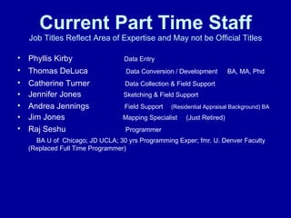
- 8. Current Part Time Staff Job Titles Reflect Area of Expertise and May not be Official Titles Phyllis Kirby Data Entry Thomas DeLuca Data Conversion / Development BA, MA, Phd Catherine Turner Data Collection & Field Support Jennifer Jones Sketching & Field Support Andrea Jennings Field Support (Residential Appraisal Background) BA Jim Jones Mapping Specialist (Just Retired) Raj Seshu Programmer BA U of Chicago; JD UCLA; 30 yrs Programming Exper; fmr. U. Denver Faculty (Replaced Full Time Programmer)
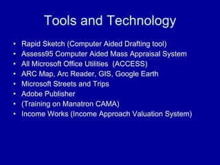
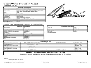
- 9. Tools and Technology Rapid Sketch (Computer Aided Drafting tool) Assess95 Computer Aided Mass Appraisal System All Microsoft Office Utilities (ACCESS) ARC Map, Arc Reader, GIS, Google Earth Microsoft Streets and Trips Adobe Publisher (Training on Manatron CAMA) Income Works (Income Approach Valuation System)
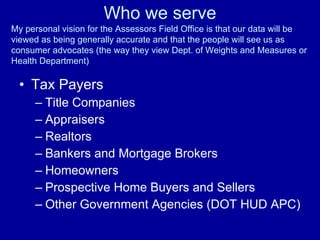
- 10. Who we serve Tax Payers Title Companies Appraisers Realtors Bankers and Mortgage Brokers Homeowners Prospective Home Buyers and Sellers Other Government Agencies (DOT HUD APC) My personal vision for the Assessors Field Office is that our data will be viewed as being generally accurate and that the people will see us as consumer advocates (the way they view Dept. of Weights and Measures or Health Department)
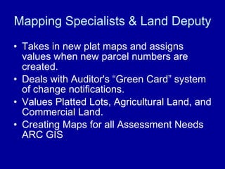
- 11. Mapping Specialists & Land Deputy Takes in new plat maps and assigns values when new parcel numbers are created. Deals with Auditor's ÔÇ£Green CardÔÇØ system of change notifications. Values Platted Lots, Agricultural Land, and Commercial Land. Creating Maps for all Assessment Needs ARC GIS
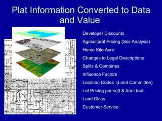
- 12. Plat Information Converted to Data and Value Developer Discounts Agricultural Pricing (Soil Analysis) Home Site Acre Changes to Legal Descriptions Splits & Combines Influence Factors Location Codes (Land Committee) Lot Pricing per sqft & front foot Land Class Customer Service
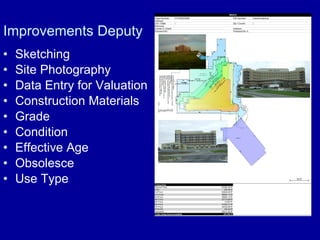
- 13. Improvements Deputy Sketching Site Photography Data Entry for Valuation Construction Materials Grade Condition Effective Age Obsolesce Use Type
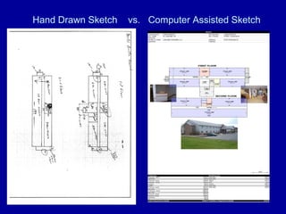
- 14. Hand Drawn Sketch vs. Computer Assisted Sketch
- 15. ╠²
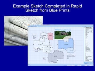
- 16. Example Sketch Completed in Rapid Sketch from Blue Prints
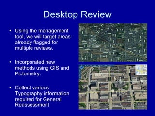
- 17. Desktop Review Using the management tool, we will target areas already flagged for multiple reviews. Incorporated new methods using GIS and Pictometry. Collect various Typography information required for General Reassessment
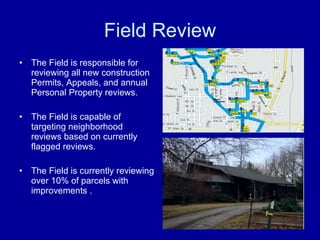
- 18. Field Review The Field is responsible for reviewing all new construction Permits, Appeals, and annual Personal Property reviews. The Field is capable of targeting neighborhood reviews based on currently flagged reviews. The Field is currently reviewing over 10% of parcels with improvements .
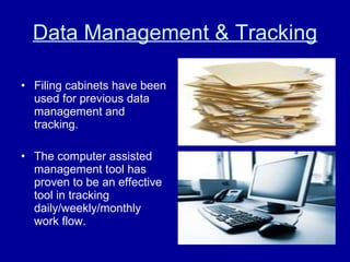
- 19. Data Management & Tracking Filing cabinets have been used for previous data management and tracking. The computer assisted management tool has proven to be an effective tool in tracking daily/weekly/monthly work flow.
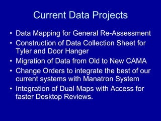
- 20. Current Data Projects Data Mapping for General Re-Assessment Construction of Data Collection Sheet for Tyler and Door Hanger Migration of Data from Old to New CAMA Change Orders to integrate the best of our current systems with Manatron System Integration of Dual Maps with Access for faster Desktop Reviews.
- 21. Triggers Receiving The Request Permits (New Construction) March 1 st-Trending Union Township (manual process contact twp) Lafayette (ftp site all permits are scanned but reports are limited) West Lafayette (Data Reports are excellent but we pick up from city) County Building Commission (Pick up down stairs limited data reports) Area Planning (Hand delivers permits to our in box, no data reports) Benton County ( Part of Otterbein is in Tipp.Co. City pulls permits in Benton) Other Triggers Appeals 133s filed by tax payers or Errors found by staff that need resolved Phone Calls Area Plan, Auditor, Highway Dept, Health Dept Real Estate Professionals Sales Disclosures (Sales that seem too high or low) GENERAL RE ASSESSMENT
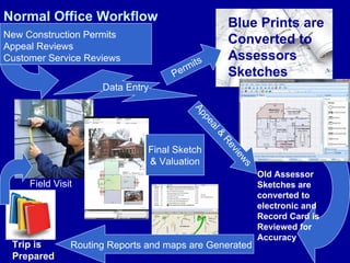
- 22. Normal Office Workflow New Construction Permits Appeal Reviews Customer Service Reviews Data Entry Permits Blue Prints are Converted to Assessors Sketches Old Assessor Sketches are converted to electronic and Record Card is Reviewed for Accuracy Routing Reports and maps are Generated Field Visit Trip is Prepared Appeal & Reviews Final Sketch & Valuation
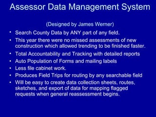
- 23. Assessor Data Management System (Designed by James Werner) Search County Data by ANY part of any field . This year there were no missed assessments of new construction which allowed trending to be finished faster. Total Accountability and Tracking with detailed reports Auto Population of Forms and mailing labels Less file cabinet work. Produces Field Trips for routing by any searchable field Will be easy to create data collection sheets, routes, sketches, and export of data for mapping flagged requests when general reassessment begins.
- 24. ╠²
- 25. ╠²
- 26. ╠²
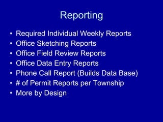
- 27. Reporting Required Individual Weekly Reports Office Sketching Reports Office Field Review Reports Office Data Entry Reports Phone Call Report (Builds Data Base) # of Permit Reports per Township More by Design
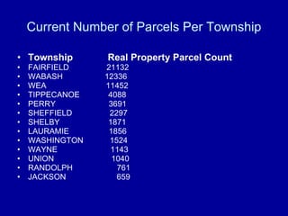
- 28. Current Number of Parcels Per Township Township Real Property Parcel Count FAIRFIELD 21132 WABASH 12336 WEA 11452 TIPPECANOE 4088 PERRY 3691 SHEFFIELD 2297 SHELBY 1871 LAURAMIE 1856 WASHINGTON 1524 WAYNE 1143 UNION 1040 RANDOLPH 761 JACKSON 659
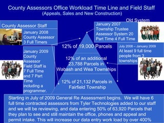
- 29. County Assessors Office Workload Time Line and Field Staff (Appeals, Sales and New Construction) January 2007 Township Trustee Assessor System 20 Part Time 4 Full Time July 2008 ÔÇô January 2009 At least 9 full time people from 3 townships January 2009 County Assessor Field Staff is 7 Full Time and 7 Part Time including a programmer. January 2008 County Assessor 3 Full Timers Starting in July of 2009 General Re Assessment begins. We will have 6 full time contracted assessors from Tyler Technologies added to our staff and we will be reviewing, and data entering 50% of 63,920 Parcels that they plan to see and still maintain the office, phones and appeal and permit intake. This will increase our data entry work load by over 400% County Assessor Staff Old System 12% of 19,000 Parcels 12% of an additional 23,788 Parcels in Wabash and Wea Townships 12% of 21,132 Parcels in Fairfield Township
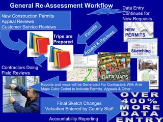
- 30. General Re-Assessment Workflow New Construction Permits Appeal Reviews Customer Service Reviews Data Entry Continues for New Requests Permits NEW PERMITS Reports and maps will be Generated For Contractors With Ariel Maps Color Coded to Indicate Permits, Appeals & Other. Trips are Prepared Appeal & Reviews Final Sketch Changes Valuation Entered by County Staff Contractors Doing Field Reviews Sketching DATA MAPS OVER 400% MORE DATA ENTRY Accountability Reporting