E Cognition User Summit2009 M Wurm Dlr Structure Types C
- 1. Mapping urban diversity Derivation of urban structure types by means of multisensoral remote sensing data Michael Wurm German Aerospace Center (DLR) German Remote Sensing Data Center (DFD) University of W¨ąrzburg, Department for Remote Sensing
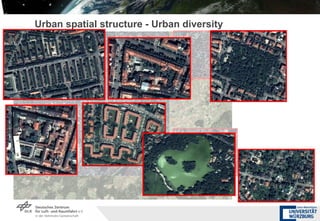
- 3. Urban spatial structure - Urban diversity
- 4. Characterisation of urban landscape for ˇ Physical furnishing of the urban area Mapping/Monitoring the urban landscape Comparability Urban planning Added-value analyses Risk- and vulnerability assessment Assessment of local heating potentials Socioeconomic data Discrimination of homogenous areas on block level ? Urban structure types
- 5. Landsat Ikonos/DSM Wickop, 1998 and Banzhaf, 2008
- 6. Image Analysis Segmentation Classification Aggregation Added-value Analysis Image Input Workflow Buildings SegOpt LCC BType DSM VHR.opt
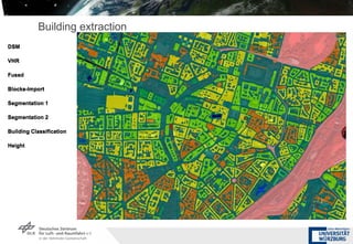
- 7. Building extraction DSM VHR Fused Blocks-Import Segmentation 1 Segmentation 2 Building Classification Height DSM VHR Fused Blocks-Import Segmentation 1 Segmentation 2 Building Classification Height DSM VHR Fused Blocks-Import Segmentation 1 Segmentation 2 Building Classification Height DSM VHR Fused Blocks-Import Segmentation 1 Segmentation 2 Building Classification Height DSM VHR Fused Blocks-Import Segmentation 1 Segmentation 2 Building Classification Height DSM VHR Fused Blocks-Import Segmentation 1 Segmentation 2 Building Classification Height DSM VHR Fused Blocks-Import Segmentation 1 Segmentation 2 Building Classification Height DSM VHR Fused Blocks-Import Segmentation 1 Segmentation 2 Building Classification Height
- 8. ?
- 9. Image Analysis Segmentation Classification Aggregation Added-value Analysis Image Input Workflow Buildings SegOpt LCC BType DSM VHR.opt
- 10. Buildings-VHR Input Basic Segmentation Optimzation Level 1 Optimization Level 2 Optimzation Level 3 Classification Building Classification Streets Import LCC .1 LCC .2 LCC .3 LCC .4 Final LCC Buildings-VHR Input Basic Segmentation Optimzation Level 1 Optimization Level 2 Optimzation Level 3 Classification Building Classification Streets Import LCC .1 LCC .2 LCC .3 LCC .4 Final LCC Buildings-VHR Input Basic Segmentation Optimzation Level 1 Optimization Level 2 Optimzation Level 3 Classification Building Classification Streets Import LCC .1 LCC .2 LCC .3 LCC .4 Final LCC Buildings-VHR Input Basic Segmentation Optimzation Level 1 Optimization Level 2 Optimzation Level 3 Classification Building Classification Streets Import LCC .1 LCC .2 LCC .3 LCC .4 Final LCC Segmentation-optimization Buildings-VHR Input Basic Segmentation Optimzation Level 1 Optimization Level 2 Optimzation Level 3 Classification Building Classification Streets Import LCC .1 LCC .2 LCC .3 LCC .4 Final LCC
- 11. Buildings-VHR Input Basic Segmentation Optimzation Level 1 Optimization Level 2 Optimzation Level 3 Classification Building Classification Streets Import LCC .1 LCC .2 LCC .3 LCC .4 Final LCC Buildings-VHR Input Basic Segmentation Optimzation Level 1 Optimization Level 2 Optimzation Level 3 Classification Building Classification Streets Import LCC .1 LCC .2 LCC .3 LCC .4 Final LCC Buildings-VHR Input Basic Segmentation Optimzation Level 1 Optimization Level 2 Optimzation Level 3 Classification Building Classification Streets Import LCC .1 LCC .2 LCC .3 LCC .4 Final LCC Buildings-VHR Input Basic Segmentation Optimzation Level 1 Optimization Level 2 Optimzation Level 3 Classification Building Classification Streets Import LCC .1 LCC .2 LCC .3 LCC .4 Final LCC Buildings-VHR Input Basic Segmentation Optimzation Level 1 Optimization Level 2 Optimzation Level 3 Classification Building Classification Streets Import LCC .1 LCC .2 LCC .3 LCC .4 Final LCC Buildings-VHR Input Basic Segmentation Optimzation Level 1 Optimization Level 2 Optimzation Level 3 Classification Building Classification Streets Import LCC .1 LCC .2 LCC .3 LCC .4 Final LCC Buildings-VHR Input Basic Segmentation Optimzation Level 1 Optimization Level 2 Optimzation Level 3 Classification Building Classification Streets Import LCC .1 LCC .2 LCC .3 LCC .4 Final LCC Classification parameter: Spectral Attributes Shape and area Features Neighborhood Texture Hierarchical Features
- 12. ?
- 13. ?
- 14. Image Analysis Segmentation Classification Aggregation Added-value Analysis Image Input Workflow Buildings SegOpt LCC BType DSM VHR.opt
- 15. Landcover Vegetation density [%] Building density Impervious surface [%]
- 16. Schrebergarten Einzel-/Doppelhausbebauung Freistehende Geschossbauten Reihenhaus Zeilenbebauung Offene Blockrandbebauung Geschlossene Blockrandbebauung Offene Blockbebauung Geschlossene Blockbebauung Geschossbaukomplexe Hallenbebauung Punkt-/Scheibenhochhaus Mischbebauung Shape parameters for classification Number of courtyards Sealed areas Vegetated areas Building elevation Building levels Compactness Volume Area Lenght/Width Length of main line Urban Structure Types
- 17. Image Analysis Segmentation Classification Aggregation Added-value Analysis Image Input Workflow Buildings SegOpt LCC BType DSM VHR.opt
- 18. Case Studies Integration of UST for social sciences Neighborhood Comparison Individual Household
- 19. Case studies Local level: Supportive analyses for district/local heating Annual heat demand / development costs Potential for district heating modeled via urban structure Buildings 0.0 ¨C 2.5 [achievable kWh/a per invested €] 2.5 ¨C 5.0 5.0 ¨C 10.0 10.0 ¨C 20.0 > 20
- 20. Summary VHR and DSM Detailed classification of urban spatial structure Urban structure types Homogenous areas Added-value analyses Local heating potentials Socioeconomic analysis [email_address]


![Landcover Vegetation density [%] Building density Impervious surface [%]](https://image.slidesharecdn.com/ecognitionusersummit2009mwurmdlrstructuretypesc-091208100620-phpapp01/85/E-Cognition-User-Summit2009-M-Wurm-Dlr-Structure-Types-C-15-320.jpg)


![Case studies Local level: Supportive analyses for district/local heating Annual heat demand / development costs Potential for district heating modeled via urban structure Buildings 0.0 ¨C 2.5 [achievable kWh/a per invested €] 2.5 ¨C 5.0 5.0 ¨C 10.0 10.0 ¨C 20.0 > 20](https://image.slidesharecdn.com/ecognitionusersummit2009mwurmdlrstructuretypesc-091208100620-phpapp01/85/E-Cognition-User-Summit2009-M-Wurm-Dlr-Structure-Types-C-19-320.jpg)
![Summary VHR and DSM Detailed classification of urban spatial structure Urban structure types Homogenous areas Added-value analyses Local heating potentials Socioeconomic analysis [email_address]](https://image.slidesharecdn.com/ecognitionusersummit2009mwurmdlrstructuretypesc-091208100620-phpapp01/85/E-Cognition-User-Summit2009-M-Wurm-Dlr-Structure-Types-C-20-320.jpg)