


More Related Content
Similar to Ermapper stitch (20)
Recently uploaded (20)


Ermapper stitch
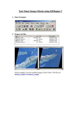
- 1. East Timor Images Mosaic using ERMapper 7 1. Open Ermapper 2. Prepare the files In this example, I use two satellite images of East Timor. The files are dataset_comp3 and dataset_comp4
- 2. 3. Run Image Display and Mosaic Method Click Browse 4. Find file (just select one of them)
- 3. 5. File(s) has been selected You can choose whatever you want. The step that I have done used the setting above. 6. Set files types and their properties. You can choose whatever you want. The step that I have done used the setting above.
- 4. 7. Select mosaic properties You can choose whatever you want. The step that I have done used the setting above. Stitch region can not be selected at the moment. 8. Select Display Method You can choose whatever you want. The step that I have done used the setting above.
- 5. 9. The result We have a terrible result. Black colour creates a bad blend. Next, we try use the (stitch) region. Close all windows except main ERMapper window 10. From ERMapper main window, Open file(s)
- 6. 11. This is one of the example files 12. Display its Algorithm 13. Open Map Composition (in Algorithm Window)
- 7. 14. I suggest, just select Raster Region mode 15. Edit the region Some files will have an automatic region. ERMapper kindly gives us the region. If you don’t like provided region just delete it by select the region and click this icon . Create a new region using this icon . Close the region with double-click.
- 8. 16. Do like this (or any shape you want) 17. Name the region using this icon 18. Type meaningful name in the box below, and press Apply
- 9. 19. Region has been named with ‘jahit’ (example) 20. Save map composition using this icon main ERMapper Window) Just press OK 21. Region ‘jahit’ has been created Just close (in map composition window, not in
- 10. 22. Do the same to another (other) image(s) In this example I have created one region on each image. The regions have the same name ‘jahit’ 23. Repeat Step 3 to Step 7 Select use stitch region, and name the region with jahit (or any name that you have given). Region name on all images has to be the same. The rest step is the same with step 8
- 11. 24. The result Overlapping region needs to be minimized. Thinner is better. The result depends on stitch regions. If we want to completely remove black colour (on the images above), we should change the region on the files. Adjust the region until overlapping region is minimised. A wide overlap creates unclear image along the edge. 25. Have a coffee and watch simpson. Thank to • University of New England for ERMapper License. • My brother Adalfredo Fereirra (Bio) for East Timor images Contact me at beni.raharjo@gmail.com