ETAP - pde gis - Data Exchange
- 1. ┬® 1996-2009 Operation Technology, Inc. ŌĆō Workshop Notes: Data Exchange Data Exchange
- 2. ║▌║▌▀Ż 2┬® 1996-2009 Operation Technology, Inc. ŌĆō Workshop Notes: Data Exchange ETAP Data Exchange ŌĆó Easy Setup ŌĆó Intelligent Mapping ŌĆó Expert Support ŌĆó International Standards ŌĆó Flexible Operation ŌĆó User Friendly
- 3. ║▌║▌▀Ż 3┬® 1996-2009 Operation Technology, Inc. ŌĆō Workshop Notes: Data Exchange ETAP Data Exchange Key Features ŌĆó Import/Export Data ŌĆó Data Synchronization ŌĆó Automatic Diagram Generator ŌĆó Intelligent Error Checking ŌĆó GIS Map Interface ŌĆó Real-Time Data Exchange
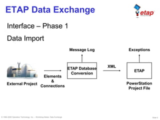
- 4. ║▌║▌▀Ż 4┬® 1996-2009 Operation Technology, Inc. ŌĆō Workshop Notes: Data Exchange ETAP Data Exchange Interface ŌĆō Phase 1 Data Import Elements & Connections XML External Project ETAP Database Conversion ETAP Message Log Exceptions PowerStation Project File
- 5. ║▌║▌▀Ż 5┬® 1996-2009 Operation Technology, Inc. ŌĆō Workshop Notes: Data Exchange ETAP Data Exchange Interface ŌĆō Phase 2 One-Way Synchronization Elements & Connections Add, Modify, & Delete Actions XML Data Mapping External Project ETAP Data Exchange ETAP Message Log Exceptions Existing Data User Confirmation
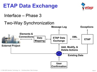
- 6. ║▌║▌▀Ż 6┬® 1996-2009 Operation Technology, Inc. ŌĆō Workshop Notes: Data Exchange ETAP Data Exchange Interface ŌĆō Phase 3 Two-Way Synchronization Add, Modify, & Delete Actions XMLData Mapping External Project ETAP Data Exchange Message Log Exceptions Existing Data User Confirmation Elements & Connections ETAP
- 7. ║▌║▌▀Ż 7┬® 1996-2009 Operation Technology, Inc. ŌĆō Workshop Notes: Data Exchange ETAP Data Exchange Database Mapping Equipment ETAP Element Equipment Attributes ETAP Element Properties
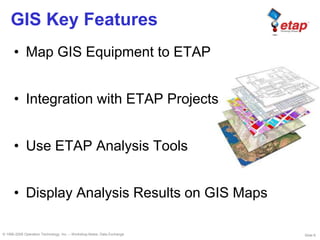
- 8. ║▌║▌▀Ż 8┬® 1996-2009 Operation Technology, Inc. ŌĆō Workshop Notes: Data Exchange GIS Key Features ŌĆó Map GIS Equipment to ETAP ŌĆó Integration with ETAP Projects ŌĆó Use ETAP Analysis Tools ŌĆó Display Analysis Results on GIS Maps
- 9. ║▌║▌▀Ż 9┬® 1996-2009 Operation Technology, Inc. ŌĆō Workshop Notes: Data Exchange GIS Capabilities ŌĆó Database mapping via a graphic user interface ŌĆó Display unlimited GIS presentations ŌĆó Perform add, modify, or delete actions ŌĆó View modifications and accept/reject action via graphical user interface ŌĆó Use map tools (zoom, pan, ŌĆ”) ŌĆó Full control of analysis results displayed on the GIS map
- 10. ║▌║▌▀Ż 10┬® 1996-2009 Operation Technology, Inc. ŌĆō Workshop Notes: Data Exchange GIS Data Exchange
- 11. ║▌║▌▀Ż 11┬® 1996-2009 Operation Technology, Inc. ŌĆō Workshop Notes: Data Exchange GIS Data Exchange
- 12. ║▌║▌▀Ż 12┬® 1996-2009 Operation Technology, Inc. ŌĆō Workshop Notes: Data Exchange GIS Data Exchange
- 13. ║▌║▌▀Ż 13┬® 1996-2009 Operation Technology, Inc. ŌĆō Workshop Notes: Data Exchange ETAP GIS Benefits ŌĆó Reduce cost by significantly reducing hours needed to perform system studies ŌĆó Avoid duplicate/incorrect data entry ŌĆó Direct communication with ESRI Geodatabase and map documents
- 14. ║▌║▌▀Ż 14┬® 1996-2009 Operation Technology, Inc. ŌĆō Workshop Notes: Data Exchange ETAP GIS Benefits ŌĆó Enter data in GIS and/or ETAP ŌĆó Flexibility to use all ETAP modules for analysis ŌĆó Multi-level graphical display of GIS and ETAP data
