


Exercise
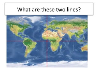
- 1. What are these two lines?
- 2. Where is the east and west? North and south?
- 3. Longitude and latitude TOKYO RÃo de Janeiro Galgari sydney
- 4. LIMA S W MONTEVIDEO S W SAN JOSÃ N W First latitude, Then longitude.
- 6. TYPE OF MAPS What kind of map projection is this?
- 7. TYPE OF MAPS What kind of map is this?
- 10. TYPE OF MAPS What kind of map is this?
- 11. TYPE OF MAPS What kind of map projection is this?
- 12. What kind of map projection is this? TYPE OF MAPS
- 13. The scale ÂŋCuÃĄnto es un cm. En este mapa? Distancia de Madrid a Lisboa: 2.7 cm. Distancia de Madrid a Zaragoza: 1.5 cm. Distancia de Madrid a CoruÃąa: 3 cm Distancia de Zaragoza a Barcelona: 1.75
- 14. THE SCALE
- 15. The scale How many km. are one cm. in this map? Distance between Madrid and Lisboa: 2.7 cm. 1 cm = 190 2.7 cm = x 1X = 190 x 2.7 X = 190 x 2.7 / 1 X= 513 / 1 X = 513 km.
- 16. The scale ÂŋCuÃĄnto es un cm. En este mapa? Distancia de Madrid a Zaragoza: 1.5 cm. 1 cm = 190 1.5 cm = X 1x = 190 x 1.5 X = 190x1.5 / 1 X= 285
- 17. TIME ZONES What is the time in Caracas if it is 9:00 PM are in the Canarias Islands? Santiago de Chile Caracas Canarias WEST EAST
- 18. TIME ZONES What is the time in Caracas if it is 9:00 PM are in the Canarias Islands? The difference: Four hours , because you count from the Greenwich meridian. And 4 hours less, because you go to the west. It means: 5:00 PM Santiago de Chile Caracas Canarias WEST EAST
- 19. TIME ZONES What time is in New York if it is 4:00 AM in Madagascar? Could you guess the season of the year in the map?
- 20. TIME ZONES What time is in New York if it is 4:00 AM in Madagascar? 8:00 PM Could you guess the season of the year in the map? Summer solstice.
- 21. TIME ZONES What is the time in Caracas if it is 9:00 PM are in the Canarias Islands? Santiago de Chile Caracas Canarias WEST EAST