Foss4 g諱íÓĂŁšČńÌïŁ©
Download as PPTX, PDF2 likes1,449 views

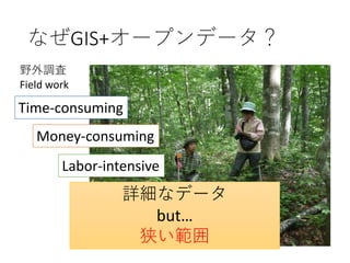
ÈŐ±Ÿ€Ç€ÏŐțžź€Î„Ș©`„Ś„ó„Ç©`„ż·œŐë€Ë»ù€Ć€Ąą”ŰĐ΀äÍÁ”ŰÀûÓĂĄąÈËżÚ·ÖČŒ€Ê€É€ÎĄ©€Ê„Ç©`„ż€Ź„€„ó„ż©`„Í„Ă„ÈÉÏ€Çč«żȘ€”€ì€Æ€€€Ț€čĄŁ€·€«€·Ąą€ł€ì€é€ÎĆòŽó€Ê„Ç©`„ż€òÓĂ€€€ÆĐ€ż€ÊÇ鱚€ò”À뀿€á€Ë€ÏĄąłÒ±őł§€äžé€Ë€è€ë„Ç©`„żIÀí€Ê€ÉĄ©€Ê耷ò€Ź±ŰÒȘ€Ç€čĄŁ±Ÿ°k±í€Ç€ÏĄą„Ș©`„Ś„ó„Ç©`„ż€ò»îÓĂ€·€ÆÈŐ±ŸčúÄÚ€ÎÉúÌŹÏ”„”©`„ӄ裚ŚÔÈ»€ŹÈËĄ©€ÎÄș€é€·€Ë€â€ż€é€č{€ßŁ©€ÎÆÀę?żÉÊÓ»Ż€òĐĐ€Ê€Ă€żÊÂÀę€òÉܜ逷€Ț€čĄŁ


More Related Content
Viewers also liked (9)
Similar to Foss4 g諱íÓĂŁšČńÌïŁ© (13)
More from OSgeo Japan (20)


Recently uploaded (15)


Foss4 g諱íÓĂŁšČńÌïŁ©
- 2. ŚÔŒșœBœé ? ČńÌï X (Rei Shibata) ? ŸtșÏ”ŰÇòhŸłŃ§ŃĐŸżËù ŃĐŸżT(2017.4 ?)(Research institute for Humanity and Nature) ? éTŁșÉÁÖÉúBѧĄąÉúBÏ”„”©`„Ó„č (Forest ecology, Ecological Services) ? €è€ŻÊ耊„œ„Ő„È„Š„§„ą (Software) ? R (2010?ŁșœyÓIÀíĄąCДѧÁĄ) ? STAN (2016?Łș„Ù„€„ș) ? QGIS (2016?) ? ArcGIS (2017.8?)
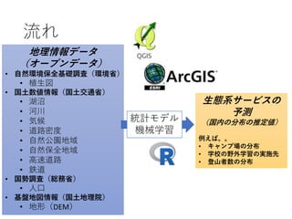
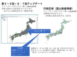
- 5. „Ș©`„Ś„ó„Ç©`„ż€ÎÀę ?ŚÔÈ»hŸł±ŁÈ«»ù”AŐ{ËŁšhŸłÊĄŁ© e.g.) Vegetation data ?čúÍÁÊęÇéóŁščúÍÁœ»ÍšÊĄŁ© ?čúĘŐ{ËŁšŸtŐÊĄŁ©e.g. )Population density ?»ù±P”ŰíÇéóŁščúÍÁ”ŰÀíÔșŁ©DEM ?ĐlĐÇ»ÏńŁšLandsat”ÈŁ© „Ù„Ż„È„ë„ż„€„룿
- 9. ÊÂÀę
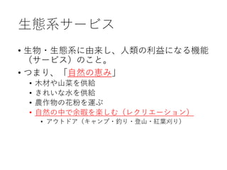
- 10. ÉúBÏ”„”©`„Ó„č ? ÉúÎï?ÉúBÏ”€ËÓÉÀŽ€·ĄąÈËî€ÎÀûÒæ€Ë€Ê€ëCÄÜ Łš„”©`„ӄ裩€Î€ł€ÈĄŁ ? €Ä€Ț€êĄąĄžŚÔÈ»€Î{€ßĄč ? ÄŸČÄ€äÉœČË€òč©œo ? €€ì€€€ÊËź€òč©œo ? ȚrŚśÎï€Î»š·Û€òß\€Ö ? ŚÔÈ»€ÎÖĐ€ÇÓàÏŸ€òS€·€àŁš„ì„Ż„ê„š©`„·„ç„óŁ© ? „ą„Š„È„É„ąŁš„„ă„ó„Ś?á€ê?”ÇÉœ?ŒtÈ~ŰŚ€êŁ©
- 11. „„ă„ó„Śö€Î·ÖČŒ€òÓèyŁż ? ÈŐ±ŸčúÄڀ΄„ă„ó„Śö€Î·ÖČŒ€òĄžŚÔÈ»hŸłĄč€È ĄžÉç»áhŸłĄč€«€éÓèy€č€ë€ł€È€Ź€Ç€€ë€«Łż ŚÔÈ»hŸł ? ÉÁÖ ? șț ? ö€·€€ ? ɜŽ Éç»áhŸł ? œü€€ ? žßËÙ”À· ? „ł„ó„Ó„Ë ? ÈË€ŹÉـʀ€
- 12. Áś€ì ”ŰÀíÇéó„Ç©`„ż Łš„Ș©`„Ś„ó„Ç©`„żŁ© ? ŚÔÈ»hŸł±ŁÈ«»ù”AŐ{ËŁšhŸłÊĄŁ© ? ÖČÉúí ? čúÍÁÊęÇéóŁščúÍÁœ»ÍšÊĄŁ© ? șțŐÓ ? șÓŽš ? Ęșò ? ”À·ĂÜ¶È ? ŚÔÈ»č«@”ŰÓò ? ŚÔÈ»±ŁÈ«”ŰÓò ? žßËÙ”À· ? â”À ? čúĘŐ{ËŁšŸtŐÊĄŁ© ? ÈËżÚ ? »ù±P”ŰíÇéóŁščúÍÁ”ŰÀíÔșŁ© ? ”ŰĐÎŁšDEMŁ© œyÓ„â„Ç„ë CДѧÁ ÉúBÏ”„”©`„Ó„č€Î Óèy ŁščúÄڀηÖČŒ€ÎÍƶšŁ© Àꀚ€ĐĄŁĄŁ ? „„ă„ó„Śö€Î·ÖČŒ ? ѧУ€ÎÒ°ÍâѧÁ€ÎgÊ©ÏÈ ? ”ÇÉœŐßÊę€Î·ÖČŒ
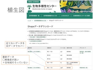
- 13. œń»Ű€ÏArcGIS€òÊčÓĂ ?ŽóÒÄŁ„Ç©`„ż€Ë€·€ÆQGIS€ÏĄ ? „ž„Ș„á„È„ê„š„é©`îl°kŁšÓËă€Ç€€Ê€€ŁĄŁ© ? UpdateCÄÜ€Źo€€Łż ? ÓË』ArcGIS€è€êßW€€Łż ? Âä€Á€ë€ł€È€Ź¶à€€ ArcGIS updateCÄÜ ŽóÒÄŁ„Ç©`„ż€Ë€·€Æ€Ïœń €Î€È€ł€íArcGIS€Ź„ê©`„ÉŁż ĄùPostGIS€òÊ耊€ÈÁŒ€€€é€·€€ŁĄ
- 23. II „ł„±„â„âŁ„È„Š„Ò„Ż„é„čÓòŚÔÈ»ÖČÉú 04žßÉœĄáÈ~äÁÖŁš±±șŁ”ÀŁ© 05žßÉœĄáÈ~äÁÖ 06žßÉœĄÚÈ~äÁÖ 07žßŸ„ČĘÔŒ°€ÓïLĐnČĘÔ V „Ö„Ê„Ż„é„čÓòŽúÖČÉú 22ÂäÈ~ÚÈ~ä¶țŽÎÁÖ 23łŁŸvä¶țŽÎÁÖ 24ÂäÈ~ÚÈ~”ÍÄŸÈșÂä 25¶țŽÎČĘÔ 26·„ńÛE”ŰÈșÂä VII „ä„Ö„Ä„Đ„„Ż„é„čÓòŽúÖČÉú 40łŁŸvÚÈ~ä¶țŽÎÁÖ 41ÂäÈ~ÚÈ~ä¶țŽÎÁÖ 42łŁŸváÈ~ä¶țŽÎÁÖ 43„ż„±?„”„”ÈșÂä 44”ÍÄŸÈșÂä 45¶țŽÎČĘÔ 46·„ńÛE”ŰÈșÂä I žßÉœĄŚÔÈ»ÖČÉúÓò 01žßÉœ”ÍÄŸÈșÂä 02žßÉœ„Ï„€„ÇŒ°€ÓïLĐnČĘÔ 03Ń©ÌïČĘÔ III „ł„±„â„âŁ„È„Š„Ò„Ż„é„čÓòŽúÖČÉú 08žßÉœĄ¶țŽÎÁÖ 09¶țŽÎČĘÔ 10·„ńÛE”ŰÈșÂä IV „Ö„Ê„Ż„é„čÓòŚÔÈ»ÖČÉú 11ÂäÈ~ÚÈ~äÁÖŁšÈŐ±ŸșŁĐÍŁ© 12ÏÂČżáڻ윻ÁÖ 13ÂäÈ~ÚÈ~äÁÖŁšÌ«ÆœŃóĐÍŁ© 14ÀäÎÂĄáÈ~äÁÖ 15ŃҜǔŰáÈ~äÁÖ 16lĆÏÁÖ 17ŐÓgÁÖ 18șÓȚxÁÖ 19ŃҜǔŰ?ïLĐn”Ű”ÍÄŸÈșÂä 20€Ê€À€ì”ŰŚÔÈ»”ÍÄŸÈșÂä 21ŚÔÈ»ČĘÔ VI „ä„Ö„Ä„Đ„„Ż„é„čÓòŚÔÈ»ÖČÉú 27łŁŸvÚÈ~äÁÖ 28ĆŻÎÂĄáÈ~äÁÖ 29ŃҜǔŰ?șŁ°¶¶ÏŃ”ŰáÈ~äÁÖ 30ÂäÈ~ÚÈ~äÁÖ 31ŐÓgÁÖ 32șÓȚxÁÖ 33ŚÔÈ»”ÍÄŸÈșÂä 34șŁ°¶ïLĐn”ÍÄŸÈșÂä 35ᥳŁŸvÚÈ~äÁÖ 36ᥳŁŸvÚÈ~äÁÖ ŁšÂĄÆđÊŻ»ÒŃÒÉÏŁ© 37áĄÊȘÉúÁÖ Łš„Ț„ó„°„í©`„ÖÁÖŁ© 38ᥳŁŸváÈ~äÁÖ 39ᥔÍÄŸÈșÂä VIII șÓȚx?ÊȘÔ?ŐÓg”Ű?É°ÇđÖČÉú 47ÊȘÔ?șÓŽš?łŰŐÓÖČÉú 48cŐÓ”ŰÖČÉú 49É°ÇđÖČÉú 50șŁ°¶¶ÏŃ”ŰÖČÉú 51ŃҜǔŰ?ÊŻ»ÒŃÒ”Ű?ÉߌyŃÒ”ŰÖČÉú 52»đÉœ»ÄÔÖČÉú?Áò»ÆżŚÔÖČÉú 53ÂĄÆđÉșșśœžÖČÉú X ÊĐœÖ”Ű”È 58ÊĐœÖ”Ű”È IX ÖČÁÖ”Ű?žûŚś”ŰÖČÉú 54ÖČÁÖ”Ű 55ÖńÁÖ 56ÄÁČĘ”Ű?„Ž„ë„Őö?Ö„”Ű 57žûŚś”Ű
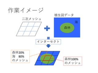
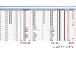
- 24. new.vg.group <- function(df) { primary <- c(1:7, 11:21, 27:39, 47:53) secondary <- c(8:10, 22:26, 40:46) plantation <- c(54, 55) pasture <- 56 cultivated <- 57 urban <- 58 sea <- 0 df$NEW <- ifelse( df$DAI_C %in% primary, "primary", ifelse( df$DAI_C %in% secondary, "secondary", ifelse( df$DAI_C %in% plantation, "plantation", ifelse( df$DAI_C %in% pasture, "pasture", ifelse( df$DAI_C %in% cultivated, "cultivated", ifelse( df$DAI_C %in% urban, "urban", ifelse(df$DAI_C %in% sea, "unknown", "unknown") ) ) ) ) ) ) df$NEW <- ifelse( df$NEW == "urban" & df$CHU_C == 6, "water", df$NEW ) df$NEW <- ifelse( df$NEW == "water", ifelse(df$LAND == 1, "inland.water", "sea.water"), df$NEW ) df$NEW <- ifelse( df$NEW == "unknown", ifelse(df$LAND == 1, "unknown", "sea.water"), df$NEW ) return(df) } R€ÇŒŻÓ R€Çcsv„Ő„Ą„€„ë€òŐi€ßȚz€ßĄąžś „á„Ă„·„怎€È€Î±»žČÂÊ€òŒŻÓ ?ŚÔÈ»ÖČÉú ?¶țŽÎÖČÉú ?ÖČÁÖ ?žûŚś”Ű ?ÄÁČĘ”Ű ?ÊĐœÖ”Ű ?êËź ?șŁ
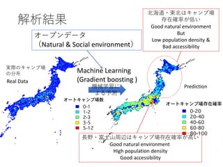
- 26. CДѧÁ€Ë €è€ëÓèy Machine Learning (Gradient boosting ) „Ș©`„Ś„ó„Ç©`„ż ŁšNatural & Social environmentŁ© ±±șŁ”À?|±±€Ï„„ă„ó„Śö ŽæÔÚŽ_ÂÊ€Ź”Í€€ Good natural environment But Low population density & Bad accessibility éLÒ°?ž»ÊżÉœÖÜȚx€Ï„„ă„ó„ŚöŽæÔÚŽ_ÂÊ€Źžß€€ Good natural environment High population density Good accessibility œâÎöœYčû Real Data Prediction gëH€Î„„ă„ó„Śö €Î·ÖČŒ
- 27. Thank you!! Research institute for Humanity and Nature(RIHN) Rei Shibata rei@chikyu.ac.jp