Geo enabling trade data analysis
Download as pptx, pdf1 like837 views

This document discusses using trade data and geospatial mapping to identify opportunities for foreign direct investment (FDI). It describes mapping import and export cargo volumes to reveal key global companies, industries, and trade routes. Linking trade data with contact and location information in a geospatial interface allows users to visualize trade flows and dynamics between countries to proactively pursue FDI prospects. The solution aims to provide intelligence on economic activities of companies for expansion opportunities.


Geo enabling trade data analysis
- 1. Geo Enabling International Trade Data Analysis Identifying FDI Opportunities
- 2. Page 2 Goal: Identify Prospects for FDI ? Our trade data reveals the foreign companies with significant and/or increasing cargo volumes. ? Mapping trade flows ¨C logistical details, destinations and recipients ¨C reveals opportunities (potential for transport hubs, industry clusters, trade zones, etc.) ? Data-driven intelligence about companiesˇŻ economic activities identifies top candidates for expansion in the US. ? Datamyne-Esri solution aims at making economic development proactive ˇ
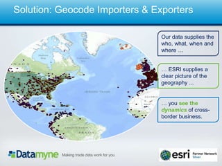
- 3. Page 3 Our data supplies the who, what, when and where ˇ ˇ ESRI supplies a clear picture of the geography ... ˇ you see the dynamics of cross- border business. Solution: Geocode Importers & Exporters
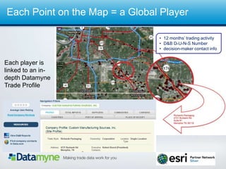
- 4. Each Point on the Map = a Global Player ? 12 monthsˇŻ trading activity ? D&B D-U-N-S Number ? decision-maker contact info Each player is linked to an in- depth Datamyne Trade Profile
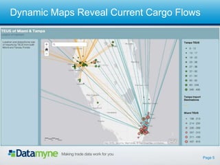
- 5. Page 5 Dynamic Maps Reveal Current Cargo Flows
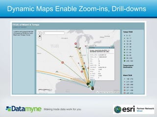
- 6. Page 6 Dynamic Maps Enable Zoom-ins, Drill-downs
- 7. Page 7 To Learn More: ? Visit: www.datamyne.com ? E-Mail: Mark Condon mark.condon@datamyne.com ? Call: Mark Condon (305) 455-3639 or (843) 670-4243 ? Write: Datamyne Inc. 703 Waterford Way, Suite 200 Miami, FL 33126 USA