Geohash
- 1. Geohash {lat/lon â string} Python Developer Nepal Meetup #6 March 19, 2015
- 2. Who am I? Narayan Kandel Developer at nLocate (Python/Django) Previously Java Developer at Deerwalk
- 3. What I Will Cover 1. Our requirements 2. What is a geohash? 3. How does it work? 4. How we use it?
- 4. Our Requirement â Analyze visitor from different location â different data 1. business data 2. user generated log â Duplication Check
- 5. What is Geohashing Simple way to encode lat/lng into a string Compact string encoding of geographic coordinate with arbitrary precision Kathmandu - tuut, Chitwan - tuuj Invented by Gustavo Niemeyer for geohash.org Available in public domain http://en.wikipedia.org/wiki/geohash/
- 6. Why do we need it when we have lat/lon Big address of venue ABC road Lalitpur Sub-Municipality -12, Kupondole Lalitpur, Bagmati Nepal Complicated Lat/Long {27.6830282799,85.3180309269}
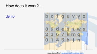
- 7. â Subdivides space into "buckets" of grid shape â Doesn't really represent a point, rather a bounding area in which the point is present â Hierarchical spatial structure with gradual degradation â Longer the geohash â Smaller the area snap taken from geohash.gofreerange.com
- 8. How does it work?
- 9. How does it work?
- 10. Mapping 5 bits (25 ) = 32 alpha-numeric 1-9 b-z except a, i, l, o *http://en.wikipedia.org/wiki/Geohash
- 11. How does it work?... demo snap taken from geohash.gofreerange.com
- 12. Lets come to our problem â Analyze visitor from different location Method 1: Polygon
- 13. Analyze visitor from different location ... Method 2 Geohashing Prefix Matching
- 14. Other Area Where we used it â To find duplicate Spot - O(n2 )
- 15. Other Application â twitter - location based tweet count/find trend on particular location â flickr/instagram - find location based photo with area selection on number of prefix â alerter system at telecommunication (integration of hardware location + customer complain location) â and many more...
- 16. References â Geohash - http://en.wikipedia.org/wiki/Geohash
- 17. Thank You twitter: @dearnarayan email: narayan@nlocate.com


