Gis for media election monitoring
â¢Download as PPTX, PDFâ¢
1 likeâ¢1,325 views

GeoIT Consult provides GIS and software development services. They have developed a National GIS Media Election Monitoring System to analyze election data and report results. This includes desktop, web, and mobile interfaces to view voting patterns, candidate performance, and other metrics at the national, constituency, and electoral area levels. The system aims to increase transparency and fact-based reporting of elections.


Gis for media election monitoring
- 1. GeoIT Consult NATIONAL GIS REPORTING SYSTEM & BEYOND Ebenezer Odoi Frederick Kofi Ansah Francis Ocansey CEO Project Manager Project Consultant ebenezer.odoi@gmail.com kofians2@yahoo.com kwamenath@yahoo.com Ghana: Box AT 2113 Achimota (0244231278/0245-346366) USA: 4770 Indianola Ave Ste 200 Columbus OH 43214 www.geoitconsult.com info@geoitconsult.com © 2011
- 2. OUR PHILOSOPHY At GeoIT Consult our mission is to provide clients with high quality, innovative and globally competitive solution models AREAS OF OPERATION ⢠*Geoinformatics (GIS/GPS/Remote Sensing) ⢠Software / Database Development ⢠Web and Graphic Designing ⢠Training ⢠Research * focus of this presentation © 2011
- 3. NATIONAL *GIS MEDIA ELECTION MONITORING SYSTEM who why where which when how what © 2011 * Geographic Information System
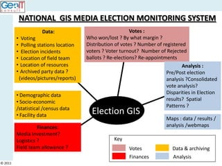
- 4. NATIONAL GIS MEDIA ELECTION MONITORING SYSTEM Data: Votes : ⢠Voting Who won/lost ? By what margin ? ⢠Polling stations location Distribution of votes ? Number of registered ⢠Election incidents voters ? Voter turnout? Number of Rejected ⢠Location of field team ballots ? Re-elections? Re-appointments ⢠Location of resources Analysis : ⢠Archived party data ? Pre/Post election (videos/pictures/reports) analysis ?Consolidated vote analysis? ⢠Demographic data Disparities in Election ⢠Socio-economic results? Spatial /statistical /census data Patterns ? ⢠Facility data Election GIS Maps : data / results / Finances: analysis /webmaps Media Investment? Logistics ? Key Field team allowance ? Votes Data & archiving Finances Analysis © 2011
- 5. Issues ..???? ⢠Rejected/valid Ballots ⢠Rigging ⢠Registered voters ⢠Non-voters ⢠Absent voters ⢠Voting patterns ⢠Population Density ⢠Local Govât elections © 2011
- 6. 1. Desktop Interfaces © 2011
- 7. Myths ..assumptions...National Level ?? © 2011
- 8. Myths ..assumptions...Constituency Level ?? © 2011
- 9. Myths ..assumptions...EA Level ?? © 2011
- 10. 2. Web Interfaces © 2011
- 11. Web Interfaces © 2011 http://www.gotmaps.biz/ghana.php
- 14. 3. Mobile Interfaces for media reporting © 2011
- 15. MONITORING REPORTING MOBILE APPLICATION © 2011
- 16. MONITORING REPORTING MOBILE APPLICATION Nana Akuffo Addo © 2011
- 17. Nana Addo Danquah Akuffo Addo © 2011
- 18. Nana Addo Danquah Akuffo Addo © 2011
- 19. Procedure repeated for Parliamentary elections © 2011
- 20. © 2011
- 21. © 2011
- 22. © 2011
- 23. © 2011
- 24. © 2011
- 25. Further involvement of GIS applications in Media service delivery © 2011
- 26. Understanding size and effect âmaps transform data into useful knowledge about the areas in which we work or Resource propose to work inâ Management Population Studies Public Information © 2011
- 27. Comparing and publishing results Community Planning Monitoring Development Facility Mapping © 2011
- 28. Analyzing trends Trends based on existing data
- 29. Analyzing Events
- 30. Presenting to the media GIS is becoming an integral way to convey the context and meaning of the news. GIS Provides: ï± Unbiased reporting â Display patterns and trends with clear infographics. ï± Use geospatial analysis to investigate stories. Quickly explore demographic data to provide human context to other data. ï± Localized news â Make the news personal by reporting on information from a neighborhood level.
- 31. THANK YOU We are looking forward to a great partnership www.geoitconsult.com info@geoitconsult.com Registration: Ghana (CA-65-478) USA (Ohio-201023600749)