
1 of 8
Download to read offline

Ad
Recommended
Platforma ArcGIS a pĆedstavenĂ ArcGIS Pro
Platforma ArcGIS a pĆedstavenĂ ArcGIS ProJan NovotnĂœ
Ìę
Platforma ArcGIS a pĆedstavenĂ ArcGIS Pro (Roll-out 2015)ArcGIS for Server a Portal for ArcGIS
ArcGIS for Server a Portal for ArcGISJan NovotnĂœ
Ìę
ArcGIS for Server a Portal for ArcGIS (Roll-out 2015)Registr sÄĂtacĂch obvodĆŻ ÄSĂ
Registr sÄĂtacĂch obvodĆŻ ÄSĂÄeskĂœ statistickĂœ ĂșĆad
Ìę
Prezentace ÄeskĂ©ho statistickĂ©ho ĂșĆadu o registru sÄĂtacĂch obvodĆŻ a jeho vyuĆŸĂtĂ v (geo)demografii. IndikĂĄtory pro ĂșzemnĂ plĂĄnovĂĄnĂ nejen v turistice na bĂĄzi otevĆenĂœch dat final
IndikĂĄtory pro ĂșzemnĂ plĂĄnovĂĄnĂ nejen v turistice na bĂĄzi otevĆenĂœch dat finalWirelessInfo
Ìę
1. nĂĄrodnĂ workshop projektu ATTRACTIVE DANUBE: NĂĄrodnĂ indikĂĄtory, Praha 8.6. 2017
Co vĆĄe dokĂĄĆŸete s mobilnĂmi aplikacemi.
Co vĆĄe dokĂĄĆŸete s mobilnĂmi aplikacemi.Jan NovotnĂœ
Ìę
Prezentace ARCDATA PRAHA na konferenci ISSS 2016.RastrovĂœ GIS â Roll-out 2019
RastrovĂœ GIS â Roll-out 2019Jan NovotnĂœ
Ìę
PĆedstavenĂ novinek v rastrovĂ©m GIS (Roll-out 2019)
Inka TesaĆovĂĄNovinky v ArcGIS â Roll-out 2019
Novinky v ArcGIS â Roll-out 2019Jan NovotnĂœ
Ìę
PĆedstavenĂ novinek v systĂ©mu ArcGIS (Roll-out 2019)
Radek Kuttelwascher
Vizualizace ve webovĂ©m GIS â Roll-out 2019
Vizualizace ve webovĂ©m GIS â Roll-out 2019Jan NovotnĂœ
Ìę
This document discusses various types of web GIS services and layers for visualizing and displaying geospatial data on the web. It outlines map services, tile services, feature services and image services that can power dynamic, tiled and feature layers. It provides examples of using map image layers, tiled layers, feature layers and tile services with different data types. The document also demonstrates services and layers in a web GIS portal and map viewer with examples of traffic incidents, addresses and real estate development data.GIS Ostrava 2018 â Insights for ArGIS
GIS Ostrava 2018 â Insights for ArGISJan NovotnĂœ
Ìę
This document discusses Insights for ArcGIS, a new tool for analyzing and visualizing data in ArcGIS. It can perform descriptive data analysis graphically and intuitively. Insights connects analysis and visualization through interactive cards. It works directly with individual data fields and generates a spatial or temporal model in the background. Results are created on relevant cards and can be shared, collaborated on, and embedded in Story Maps. Insights can be used online through ArcGIS Online or on-premises with ArcGIS Enterprise.Prostorove informace
v procesech verejne spravy
Prostorove informace
v procesech verejne spravyJan NovotnĂœ
Ìę
ProstorovĂ© informace zefektivĆujĂ komunikaci napĆĂÄ ĂșĆadem i mezi ĂșĆadem a obÄanem. Integrace garantovanĂœch referenÄnĂch prostorovĂœch dat zpĆesĆuje a tĂm i zrychluje ĆeĆĄenĂ Ășloh jednotlivĂœch agend. VĆĄechny potĆebnĂ© informace jsou zpĆĂstupĆovĂĄny formou sluĆŸeb umoĆŸĆujĂcĂch provoz aplikacĂ, kterĂ© ĂșĆadu pomĂĄhajĂ pĆi vĂœkonu jednotlivĂœch agend i v lepĆĄĂ komunikaci s obÄany. ObÄan mĂĄ snazĆĄĂ orientaci pĆi ĆeĆĄenĂ tÄch svĂœch ĆŸivotnĂch situacĂ, kterĂ© ĆeĆĄĂ pĆirozenÄ nad mapou a mĆŻĆŸe tak zĂĄroveĆ lĂ©pe poskytnout i zpÄtnou vazbu ĂșĆadu.
Jak zkrotit rastry - 2. dĂl (Lucie PatkovĂĄ)
Jak zkrotit rastry - 2. dĂl (Lucie PatkovĂĄ)Jan NovotnĂœ
Ìę
DruhĂœ dĂl firemnĂho workshopu na Sympoziu GIS Ostrava 2012.Jak zkrotit rastry - 1. dĂl (Radek Kuttelwascher)
Jak zkrotit rastry - 1. dĂl (Radek Kuttelwascher)Jan NovotnĂœ
Ìę
PrvnĂ dĂl firemnĂho workshopu na Sympoziu GIS Ostrava 2012.More Related Content
What's hot (6)
Co vĆĄe dokĂĄĆŸete s mobilnĂmi aplikacemi.
Co vĆĄe dokĂĄĆŸete s mobilnĂmi aplikacemi.Jan NovotnĂœ
Ìę
Prezentace ARCDATA PRAHA na konferenci ISSS 2016.RastrovĂœ GIS â Roll-out 2019
RastrovĂœ GIS â Roll-out 2019Jan NovotnĂœ
Ìę
PĆedstavenĂ novinek v rastrovĂ©m GIS (Roll-out 2019)
Inka TesaĆovĂĄMore from Jan NovotnĂœ (11)
Novinky v ArcGIS â Roll-out 2019
Novinky v ArcGIS â Roll-out 2019Jan NovotnĂœ
Ìę
PĆedstavenĂ novinek v systĂ©mu ArcGIS (Roll-out 2019)
Radek Kuttelwascher
Vizualizace ve webovĂ©m GIS â Roll-out 2019
Vizualizace ve webovĂ©m GIS â Roll-out 2019Jan NovotnĂœ
Ìę
This document discusses various types of web GIS services and layers for visualizing and displaying geospatial data on the web. It outlines map services, tile services, feature services and image services that can power dynamic, tiled and feature layers. It provides examples of using map image layers, tiled layers, feature layers and tile services with different data types. The document also demonstrates services and layers in a web GIS portal and map viewer with examples of traffic incidents, addresses and real estate development data.GIS Ostrava 2018 â Insights for ArGIS
GIS Ostrava 2018 â Insights for ArGISJan NovotnĂœ
Ìę
This document discusses Insights for ArcGIS, a new tool for analyzing and visualizing data in ArcGIS. It can perform descriptive data analysis graphically and intuitively. Insights connects analysis and visualization through interactive cards. It works directly with individual data fields and generates a spatial or temporal model in the background. Results are created on relevant cards and can be shared, collaborated on, and embedded in Story Maps. Insights can be used online through ArcGIS Online or on-premises with ArcGIS Enterprise.Prostorove informace
v procesech verejne spravy
Prostorove informace
v procesech verejne spravyJan NovotnĂœ
Ìę
ProstorovĂ© informace zefektivĆujĂ komunikaci napĆĂÄ ĂșĆadem i mezi ĂșĆadem a obÄanem. Integrace garantovanĂœch referenÄnĂch prostorovĂœch dat zpĆesĆuje a tĂm i zrychluje ĆeĆĄenĂ Ășloh jednotlivĂœch agend. VĆĄechny potĆebnĂ© informace jsou zpĆĂstupĆovĂĄny formou sluĆŸeb umoĆŸĆujĂcĂch provoz aplikacĂ, kterĂ© ĂșĆadu pomĂĄhajĂ pĆi vĂœkonu jednotlivĂœch agend i v lepĆĄĂ komunikaci s obÄany. ObÄan mĂĄ snazĆĄĂ orientaci pĆi ĆeĆĄenĂ tÄch svĂœch ĆŸivotnĂch situacĂ, kterĂ© ĆeĆĄĂ pĆirozenÄ nad mapou a mĆŻĆŸe tak zĂĄroveĆ lĂ©pe poskytnout i zpÄtnou vazbu ĂșĆadu.
Jak zkrotit rastry - 2. dĂl (Lucie PatkovĂĄ)
Jak zkrotit rastry - 2. dĂl (Lucie PatkovĂĄ)Jan NovotnĂœ
Ìę
DruhĂœ dĂl firemnĂho workshopu na Sympoziu GIS Ostrava 2012.Jak zkrotit rastry - 1. dĂl (Radek Kuttelwascher)
Jak zkrotit rastry - 1. dĂl (Radek Kuttelwascher)Jan NovotnĂœ
Ìę
PrvnĂ dĂl firemnĂho workshopu na Sympoziu GIS Ostrava 2012.Ad
VyuĆŸitĂ dat RĂIAN v praxi
- 1. VyuĆŸitĂ dat RĂIAN v praxi Petr Urban
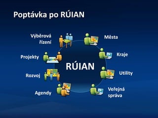
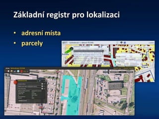
- 3. ZĂĄkladnĂ registr pro lokalizaci âą adresnĂ mĂsta âą parcely
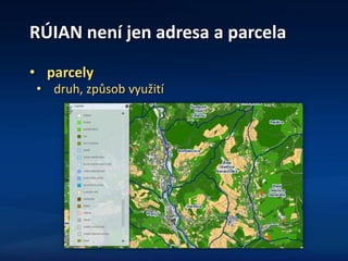
- 4. RĂIAN nenĂ jen adresa a parcela âą parcely âą druh, zpĆŻsob vyuĆŸitĂ
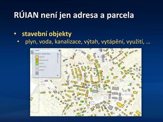
- 5. RĂIAN nenĂ jen adresa a parcela âą stavebnĂ objekty âą plyn, voda, kanalizace, vĂœtah, vytĂĄpÄnĂ, vyuĆŸitĂ, âŠ
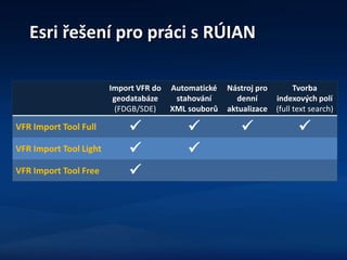
- 6. Esri ĆeĆĄenĂ pro prĂĄci s RĂIAN Import VFR do geodatabĂĄze (FDGB/SDE) AutomatickĂ© stahovĂĄnĂ XML souborĆŻ NĂĄstroj pro dennĂ aktualizace Tvorba indexovĂœch polĂ (full text search) VFR Import Tool Full ïŒ ïŒ ïŒ ïŒ VFR Import Tool Light ïŒ ïŒ VFR Import Tool Free ïŒ
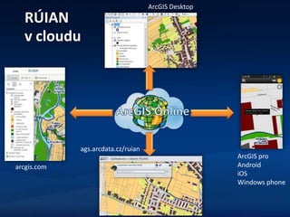
- 7. RĂIAN v cloudu ags.arcdata.cz/ruian arcgis.com ArcGIS pro Android iOS Windows phone ArcGIS Desktop