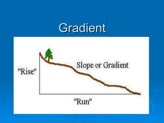
Gradient 091005034643-phpapp02
0 likes74 views

This document discusses how to measure and describe gradients on maps and in the field. It explains that gradient measures the steepness of a slope by calculating the rise over the run between two points. It provides examples of how to calculate gradient given measurements of rise and run in meters. Finally, it discusses how gradient relates to land use, providing the example of how steeper gradients can contribute to more severe bushfires.

Gradient 091005034643-phpapp02
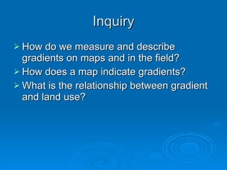
- 2. InquiryInquiry ï How do we measure and describeHow do we measure and describe gradients on maps and in the field?gradients on maps and in the field? ï How does a map indicate gradients?How does a map indicate gradients? ï What is the relationship between gradientWhat is the relationship between gradient and land use?and land use?
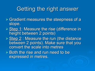
- 3. Getting the right answerGetting the right answer ï Gradient measures the steepness of aGradient measures the steepness of a slope.slope. ï Step 1Step 1: Measure the rise (difference in: Measure the rise (difference in height between 2 points)height between 2 points) ï Step 2Step 2 : Measure the run (the distance: Measure the run (the distance between 2 points). Make sure that youbetween 2 points). Make sure that you convert the scale into metresconvert the scale into metres ï Both the rise and run need to beBoth the rise and run need to be expressed in metres.expressed in metres.
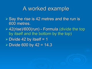
- 4. A worked exampleA worked example ï Say the rise is 42 metres and the run isSay the rise is 42 metres and the run is 600 metres.600 metres. ï 42(rise)/600(run) - Formula42(rise)/600(run) - Formula (divide the top(divide the top by itself and the bottom by the top)by itself and the bottom by the top) ï Divide 42 by itself = 1Divide 42 by itself = 1 ï Divide 600 by 42 = 14.3Divide 600 by 42 = 14.3
- 5. Expressing the answerExpressing the answer ï The answer can be expressed in threeThe answer can be expressed in three ways:ways: ï a) As a statement 1 in 14.3a) As a statement 1 in 14.3 ï b) As a ratio 1: 14.3b) As a ratio 1: 14.3 ï c) As a representative fraction 1/14.3c) As a representative fraction 1/14.3
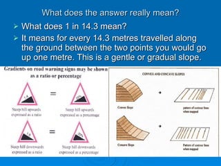
- 6. What does the answer really mean?What does the answer really mean? ï What does 1 in 14.3 mean?What does 1 in 14.3 mean? ï It means for every 14.3 metres travelled alongIt means for every 14.3 metres travelled along the ground between the two points you would gothe ground between the two points you would go up one metre. This is a gentle or gradual slope.up one metre. This is a gentle or gradual slope.
- 7. Now think of some examples ofNow think of some examples of how gradient relates to land usehow gradient relates to land use
- 8. How does the gradient of the slopeHow does the gradient of the slope contribute to the severity of bushfires?contribute to the severity of bushfires?
- 9. Create a question on gradient andCreate a question on gradient and test another studenttest another student ï Make sure you have the right answerMake sure you have the right answer before you test thembefore you test them