Gridded precipitation
1 like364 views

To use precipitation grids outside the US in HEC-HMS, two things are required: 1) loading the precipitation grids into a DSS file and 2) creating a file that associates grid cells with subbasins using GeoHMS. While GeoHMS was designed for the conterminous US, it can be used outside the US by modifying projection files to tell GeoHMS the watershed is in the US coordinate system and generating gridcell files using this "lie". Grids must also be loaded to DSS properly by understanding how row and column numbers relate to coordinates.


More Related Content
Viewers also liked (18)


Similar to Gridded precipitation (20)


More from Sikandar Ali (6)


Gridded precipitation
- 1. Using HEC-HMS and HEC-GeoHMS with Precipitation Grids Outside the Conterminous US To work with precipitation grids in HEC-HMS, two things are required. 1. A means to load your precipitation grids into records in an HEC-DSS file. 2. A file that associates cells in the grid with subbasins in the HMS basin model and assigns runoff parameters to those cells. The first of these can be the gageInterp program or one of several grid loading utilities. The second is the gridcell file created by GeoHMS. Within HMS, the cells in precipitation grids are identified by row and column number, rather than by geographic coordinates. As long as the row and column numbers in the precipitation grids are consistent with row and column numbers in the parameter file, the program will compute correctly, regardless of the watershed’s actual location. Although the GeoHMS functions that create the gridcell file were made for use in the conterminous United States, it is possible to work around this restriction and use HEC-HMS with precipitation inputs on grids outside the US. In brief, the trick is to build your watersheds in GeoHMS using GIS data in the same coordinate system that is used for your precipitation grids. To make the gridcell file, you lie to GeoHMS, telling it that your coordinate system is the US coordinate system that SHG is defined in. (See the following Appendix.) The grid parameters are calculated in rows and columns numbered from zero at the coordinate system origin. You also have to load your precipitation data into DSS. Our grid-loading programs read files written by the US National Weather Service, and is unlikely that grids generated by agencies outside the us will be available in those formats. As an alternative, HEC can provide a program that reads the text format used by ArcInfo to export grid data, and writes it to DSS. Instructions for tricking GeoHMS to create a gridcell file outside the US 1. If any of the grids used in your GeoHMS project contain projection information, remove it. This means deleting files named prj.adf from all grids (by grids, I mean the directories that hold the grid data). 2. Place a new projection file in the flow direction grid. The file must be named prj.adf and it should be ASCII text containing exactly the following lines Projection ALBERS Datum NAD83 Zunits NO Units METERS Spheroid GRS1980 Parameters 29 30 0.000 /* 1st standard parallel
- 2. 30 45 30 0.000 /* 2nd standard parallel -96 0 0.000 /* central meridian 0 0 0.000 /* latitude of projection's origin 0.00000 /* false easting (meters) 0.00000 /* false northing (meters) 3. Generate the gridcell file using the SHG grid type and a cell size to match the cells in your precipitation reporting grids. Note that SHG supports cell sizes of 10,000 m, 5,000 m, 1,000 m, 500 m, 200 m, 100 m, 50 m, 20 m, 10 m. Instructions for loading precipitation grids into DSS Grids in the form of text files can be loaded to DSS using the asc2dssGrid utility program. This program runs from the system command line, and can be embedded in a batch file or shell script for loading multiple file in one run. Instructions are included with the program. The instructions describe the both the SHG coordinate system and the format of the text file that ai2dssGrid reads. In loading grids to DSS, it is important to understand how northing and easting coordinates relate to row and column numbers in SHG. Row and column numbers are counted from the coordinate system origin, based on the assumption that the origin is the minimum-X, minimum-Y (lower left) corner of cell (0,0). If for example you are loading a grid of 1 km cells that covers a range of easting from 150 km to 175 km and northing from 500 km to 550 km, the origin cell for this grid would be in column 150, row 500, and the origin specified in the grid data file would be XLLCORNER 150000 YLLCORNER 500000.
- 3. Appendix: SHG grid system The standard hydrologic grid (SHG) is a variable-resolution square-celled map grid defined for the conterminous United States. The coordinate system of the grid is based on the Albers equal-area conic map projection with the following parameters. Units: Meters Datum: North American Datum, 1983 (NAD83) 1st Standard Parallel: 29º 30’ 0” North 2nd Standard Parallel: 45º 30’ 0” North Central Meridian: 96º 0’ 0” West Latitude of Origin: 23º 0’ 0” North False Easting: 0.0 False Northing: 0.0 Users of the grid can select a resolution suitable for the scale and scope of the study for which it is being used. For general-purpose hydrologic modeling with NEXRAD radar precipitation data, HEC recommends 2000m cells, and HEC computer programs that use the SHG for calculation will select this cell size as a default. HEC will also support the following grid resolutions: 10,000 m, 5,000 m, 1,000 m, 500 m, 200 m, 100 m, 50 m, 20 m, 10 m. The grids resulting from the different resolutions will be referred to as SHG-2km, SHG-1km, SHG-500m and so on. A grid identified as SHG with no cell-size indication will be assumed to have 2km cells For identification, each cell in the grid has a pair of integer indices (i, j) indicating the position, by cell count, of its southwest (or minimum-x, minimum-y) corner, relative to the grid’s origin at 96Ε W, 23Ε N. For example the southwest corner of cell (121, 346) in the SHG-2km grid is located at an easting of 242000 m and a northing of 692000 m. To find the indices of the cell in which a point is located, find the point’s easting and northing in the projected coordinate system defined above, and calculate the indices with the following formulas. i = floor( easting / cellsize ) j = floor( northing / cellsize ) Where floor(x) is the largest integer less than or equal to x.
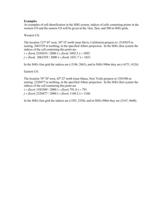
- 4. Examples As examples of cell identification in the SHG system, indices of cells containing points in the western US and the eastern US will be given in the 1km, 2km, and 500 m SHG grids. Western US: The location 121º 45′ west, 38º 35′ north (near Davis, California) projects to -2185019 m easting, 2063359 m northing, in the specified Albers projection. In the SHG-2km system the indices of the cell containing this point are i = floor( 2185019 / 2000 ) = floor( 1092.5 ) = 1093 j = floor( 2063359 / 2000 ) = floor( 1031.7 ) = 1031 In the SHG-1km grid the indices are (-2186, 2063), and in SHG-500m they are (-4371, 4126) Eastern US: The location 76º 30′ west, 42º 25′ north (near Ithaca, New York) projects to 1583506 m easting, 2320477 m northing, in the specified Albers projection. In the SHG-2km system the indices of the cell containing this point are i = floor( 1583509 / 2000 ) = floor( 791.8 ) = 791 j = floor( 2320477 / 2000 ) = floor( 1160.2 ) = 1160 In the SHG-1km grid the indices are (1583, 2320), and in SHG-500m they are (3167, 4640).