Holographic 3D Geographic Information System using Microsoft Hololens
- 1. Holo3D GIS Leveraging Microsoft HoloLens in 3D Geographic Information Yadev Jayachandran, Dept. of Computer Science & Engineering, TOC16CS059
- 2. Ever wondered how the world would be if holograms were real? 2
- 5. Mixed Reality ŌŚÅ Combining multiple realities ŌŚÅ Experiencing virtual as real 5
- 6. Microsoft HoloLens ŌŚÅ Head mount computer ŌŚÅ Gesture, gaze & voice controlled ŌŚÅ Combines multiple realities 6
- 7. Microsoft HoloLens 2: Intro video 7
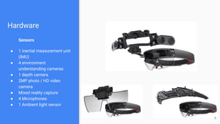
- 8. Hardware Sensors ŌŚÅ 1 inertial measurement unit (IMU) ŌŚÅ 4 environment understanding cameras ŌŚÅ 1 depth camera ŌŚÅ 2MP photo / HD video camera ŌŚÅ Mixed reality capture ŌŚÅ 4 Microphones ŌŚÅ 1 Ambient light sensor 8
- 10. Intro to Geographic Information System ŌŚÅ Store, manipulate, analyze, manage, and present spatial or geographic data ŌŚÅ Ortho-recti’¼üed imagery (from UAV, satellites etc.) ŌŚÅ Navigation & study of terrains 10
- 11. Current system Mapinfo Pro 11 GRASS GIS ArcGIS QGIS
- 12. What if we mix the two? 12
- 15. Final point A one-line description of it 15
- 16. 3D ASSET CREATION USING THE 2D DATA 16
- 17. Final point A one-line description of it 17
- 19. Final point A one-line description of it 19
- 21. Final point A one-line description of it 21
- 22. DEPLOYMENT 22
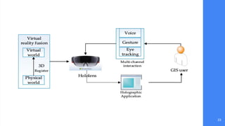
- 23. Final point A one-line description of it 23
- 25. NASA & Microsoft collaborative project: OnSight 25
- 26. Wait, thereŌĆÖs an issue... 26
- 27. ŌĆ£GIS is a huge amount of data, and when rendered realtime, it might crash the machineŌĆØ 27
- 29. Final point A one-line description of it 29
- 30. ŌŚÅ CPU utilization reduced from 71% to 47% ŌŚÅ GPU utilization reduced from 35% to 23% ŌŚÅ PC GPU utilization increased from 0% to 15% IMPACT 30
- 31. Real-world Applications ŌŚÅ Learning extra-terrestrial worlds ŌŚÅ Understanding places that are unreachable for man ŌŚÅ Deep-sea exploration & research 31
- 32. Conclusion 32
- 33. References ŌŚÅ https://www.jpl.nasa.gov/news/news.php?feature=4451 ŌŚÅ https://docs.microsoft.com/en-us/windows/mixed-reality/hololens- hardware-details ŌŚÅ https://docs.microsoft.com/en-us/windows/mixed-reality/gaze ŌŚÅ https://docs.microsoft.com/en-us/windows/mixed-reality/understa nding-performance-for-mixed-reality ŌŚÅ https://www.intel.com/content/www/us/en/tech-tips-and-tricks/virt ual-reality-vs-augmented-reality.html ŌŚÅ https://gis.usc.edu/blog/all-about-3d-gis/ 33
- 34. ŌĆ£WE ARE CHANGING THE WORLD WITH TECHNOLOGYŌĆØ - Bill Gates Co-Founder of Microsoft 34
- 35. Thank you. Presented by, Yadev Jayachandran 35


