際際滷

際際滷Share a Scribd company logo
Hybrid Positioning
The Challenge
As the adoption of location based services becomes more main-
stream, developers are looking for increased accuracy and availability
from positioning solutions. For example services that target
marketing messages need to know which display the user lingered at,
not merely which store they are in, and ideally they would know in
which direction the user is facing!

To provide ubiquitous positioning that reaches indoors and positively
identifies location and orientation in a multi-story building requires
blending the best of multiple sources of information, in other words,
a hybrid solution.


SPIRENT eBook                                                      Page   2
Ideally such a marriage of technologies allows the strengths of one to
counter the weaknesses of the other in a truly complementary way.
For example the high availability of local low cost inertial sensors
can offset GNSS which may not be available within buildings; whilst
the drift over time inherent in inertial systems can be managed using
regular high accuracy fixes from GNSS, when available.
And the sensors may not be those traditionally associated
with positioning. For example a tourist guide
application describing the scene presented to the
user answering the question What am I looking
at now ? may use the users smartphone camera
and cloud computing to overlay captions on the
display with links to appropriate informative
webpages in an augmented reality format.
SPIRENT eBook
By intelligently combining data from multiple sources the designer
aims to retain the best of each and to mitigate their weaknesses.
Truly a case of the whole exceeding the sum of the partsif it works!

The peculiar test challenge presented is that development of such a
system cannot be done one sensor at a time. The effective blending
of position information from disparate sources is predicated on an
understanding of their strengths and weaknesses, this will require
careful development and importantly, a test environment which
provides total control over multiple, coherent sources to facilitate
iterative improvement.

This e-book aims to introduce the technical challenges and
some of the ideas that Spirent has to provide the
development tools required.
SPIRENT eBook                                                     Page   4
Existing Technology
GNSS alone
Global Navigation Satellite Systems (GNSS) enable you
to locate your position anywhere on the earth  or around
it  to within millimetres. Now, you have to admit that is
an amazing statement, and in some cases it is perfectly
true, but there are limits to this incredible technologies
capability. Navigating, autonomously, using signals from
satellites orbiting some 12500km away is an almost
unbelievable technological achievement and has been the
solution to a myriad of application needs, where knowing
where and when you are is important. And, the list of
applications for GNSS navigation is growing all the time.

SPIRENT eBook                                                 Page   5
On the face of it, GNSS would appear to be the panacea for all
navigation and timing requirements. Relatively low cost, low power,
compact devices enable you to locate yourself and know the current
time with pinpoint precision. GNSS is brilliant but is it sufficient to
meet all positioning needs on its own.

While there is absolutely no doubt that GNSS is a must-have
technology for the where and when needs of todays applications,
it is not without its limitations and trade-offs. Going back to the
within millimetres statement, closer inspection reveals that to
achieve this level of accuracy takes some very sophisticated and
relatively expensive GNSS receiver technology. This is out of
the question for many of the applications that
need accurate timing and navigation.


SPIRENT eBook                                                        Page   6
So what are we left with? Accuracy of a metre? A few metres?
Hundreds of metres? The answer is yes to all of these, because the
performance of GNSS is so variable and depends on so many factors
that it is impossible to state exactly how it will perform in a generic
way. We can however consolidate performance into 4 measures:-

	Availability - The percentage of time a Position, Navigation and
   Time (PNT) solution is available
	 Continuity  Performance without non-scheduled interruptions
	 Integrity  The level of trust in the information provided
	Accuracy  The degree to which PNT data conforms to the
   actual position


SPIRENT eBook                                                         Page   7
There are many factors that alter how a GNSS receiver performs
against these measures, so lets restrict ourselves to the key issues
for consumer applications.

Availability is perhaps the most significant measure to consider given
the kinds of environments consumer devices have to operate in. The
urban scene is undoubtedly a hostile one for a GNSS receiver. Tall
buildings obscure the line of sight navigation signals, and in some
cases - if the obscuration is combined with poor satellite
geometry (not enough satellites in view)  there
wont be enough signals available to compute a
PNT solution. A minimum of 4 satellites in view
is required.


SPIRENT eBook
Go indoors, and things will probably get
much worse. The extremely weak
(c.-130dBm) signals arriving at
the Earths surface which are not
blocked by a building are further
attenuated by its fabric. Highly
sensitive receivers are required,
but these have to spend
longer and take more power
to extract the weaker signals
from the noise.


SPIRENT eBook
Accuracy is another measure which is significantly affected. The
satellite signals, even if they are not obscured, may be reflected, and
take multiple paths to the receiver antenna, much longer than the
direct path, causing false copies of the signals to arrive, late, at the
receiver corrupting the PNT calculations. Even worse is the case where
there is no line of sight signal, and the multi-path version is the only
one the receiver sees. Because the receiver uses the satellites signals
as radio tape-measures any distortion in the signals (e.g. time delay,
phase error) will degrade the PNT solution accuracy. In the case of
weak signals, a high sensitivity receiver may help, but they are more
susceptible to multipath signals.


SPIRENT eBook                                                       Page   10
So, in practice, the continuously-available millimetric accuracy
heralded at the start is rarely achieved, indeed, accuracy of several
metres can be a challenge. Therefore it is clear that GNSS alone is not
enough. We need to consider how to optimise its benefits and how
to bring the four measures of performance up to acceptable levels
for our application. This can only be achieved by augmenting GNSS.
Adding another system or multiple systems alongside GNSS to help it,
correct it or substitute for it is the practical way forward. Collectively,
this approach is known as Hybrid Positioning, the big opportunity
for performance improvement arising from the complementary nature
of the strengths and weaknesses of the various technologies. In
combination the technologies can perform better (more accurate,
higher availability etc) than any of the technologies independently.
Team work rather than competition is the way forward it seems!


SPIRENT eBook                                                         Page   11
The need for test.

With so many potential issues, testing of GNSS navigation systems is
essential. Spirent has been the leader in this field for over 25 years,
and has solutions for testing receivers on all existing and planned
GNSS systems, as well as new solutions for Hybrid Positioning.


SPIRENT eBook                                                      Page   12
Options: Sensors
A modern smartphone contains an array of sensors incorporated for a
number of purposes but all potentially available for positioning. MEMs
gyros and accelerometers, barometric sensors and magnetometers all
have a direct application in estimating position.

The inertial sensors can be used in the estimation of position by
sensing the movement of the body from a known initial position.
In this way GNSS technology, which provides accurate positions but
not all the time, and inertial technology which allows a position
estimate to be advanced in the absence of any external signals, form
a perfect partnership. The addition of magnetometers to provide
heading and barometric sensors to provide height completes a very
useful set of sensors.
SPIRENT eBook                                                    Page   13
Options: WiFi


As we have seen, the properties of radio wave propagation mean that
they lend themselves to being used for navigation  after all, thats
the foundational principle of GNSS.

SPIRENT eBook                                                   Page   14
So, with that in mind, what is to stop other radio-based techniques
being used for the same purpose? Well, actually, in some cases
nothing much. One such technique is Wi-Fi positioning. You have  in
most urban areas  many Wireless Access Points transmitting radio
signals with identifying properties. You can therefore determine your
position by looking for a fingerprint of Access Point visibility in a
large database of such devices. Combining this with a measure of
the power level received versus the databases record of the access
points transmit power to determine range, will enable
you to trilaterate from multiple Access Points.

This technique is gaining traction in the marketplace,
with both database technology suppliers and phone
handset/chipset manufacturers offering or looking         Spirent GSS5700
                                                          Wi-Fi Access Point
to offer solutions.                                       Positioning Simulator


SPIRENT eBook                                                             Page    15
Spirent is the only test equipment provider to offer a Wi-Fi test
solution. The GSS5700 Wi-Fi Access Point Positioning Simulator
consists of a smart signal generator using a core application
running on an internal CPU with touch-screen, remote MMI control
via Ethernet. Access Point Control includes the ability to specify/
change, MAC address, SSID, TX channel power level/dynamic path
loss and simulated visibility. Supporting up to 24 Access Points in
one chassis, and being able to operate with Spirents GSS6700 GNSS
simulators to give coherent GNSS/Wi-Fi test signals, makes
the GSS5700 Wi-Fi Access Point Positioning Simulator an
essential test solution for this positioning technology.


SPIRENT eBook                                                    Page   16
Options: Cellular
What is Cellular Positioning?

Cellular positioning utilizes the cellular network
infrastructure to compute position and obtain a fast
and coarse location estimate. Compared to A-GPS/A-
GLONASS, cellular network positioning is generally
faster (~5 seconds), but it is less accurate (50 meters
to several kilometres). It is quite often used as
fallback technology when GPS, GLONASS and Wi-Fi
signals are unavailable.


SPIRENT eBook                                             Page   17
Cell Identification (Cell-ID), the simplest location technology, locates
a user based on the cell they are using, though the accuracy of
this technique varies widely. Cell-ID positioning establishes the cell
to which a user equipment (UE) is currently connected and uses
that cell location as a rough estimate of the UE s current position.
Ecell-ID positioning extends the Cell-ID positioning technique with
supplementary information that narrows down the location within the
cell where the UE is located. This supplementary information includes
Timing advance and Neighbour cell measurements.

Cellular network triangulation, either signal strength-based or time-
based, can be used to improve accuracy and time-based methods
such as Time Difference of Arrival are common.


SPIRENT eBook                                                       Page   18
Cellular positioning methods currently in use comprise: Cell identity
(Cell-ID) positioning; Enhanced cell identity (Ecell-ID) positioning;
Assisted Global Positioning System (A-GPS) positioning; Advanced
Forward Link Trilateration (AFLT) in CDMA networks, Enhanced
Observed Time Difference (E-OTD) in WCDMA networks and Uplink
time difference of arrival (UTDOA) positioning. Observed downlink
time difference of arrival (OTDOA) positioning technique is currently
under discussion for LTE networks.


SPIRENT eBook                                                      Page   19
Why Cellular Network Positioning?
Pros:
 Cellular Networks cover majority of populated areas
  ellular technology is built into all mobile phones and increasing
  C
  number of other mobile devices (like connected PNDs)
 Works indoors and in urban environments
 Very fast response time
  omplementary to GNSS and
  C
  other Location Technologies
Cons:
 	Relatively poor accuracy


SPIRENT eBook                                                      Page   20
Even though all these techniques have some limitations, it is possible
to use some as stand-alone or in conjunction with GNSS and other
technologies to overcome the individual limitations. Considering the
global scale and spread of cellular networks, cellular positioning
would form an integral part of any hybrid strategy.


SPIRENT eBook                                                    Page   21
Other Sensors
The complications faced by engineers aiming to meet the ever
increasing requirements of emerging location based services (LBS)
on accuracy and availability of positioning solutions mean looking
for different and sometimes novel sources of positioning information.
Use of cell-id techniques, Wi-Fi and other sensors such as low cost
MEMs inertial are becoming more common and present unique
test challenges. The GSS6400 rises to the challenge by enabling
the user to record two channels of serial digital data alongside the
digitized GNSS spectra. Signals direct from sensors or via a bus such
as CANbus are captured and buried within the GNSS data ensuring
coherent playback. An alternative use of this facility is to record a
timing signal such as a GPS-derived 1pps which allows subsequent
synchronization of external systems such as rate tables etc.

SPIRENT eBook                                                    Page   22
Comprehensive, End-to-End Location Technology Testing
Spirents 8100 Location Technology is the evolution of the solution
known for years as the Spirent ULTS. It offers the most advanced,
comprehensive environment available for testing A-GPS/GLONASS-
enabled GSM, UMTS and LTE devices.

Location testing can be performed for standalone or hybrid location
technology using A-GPS and A-GLONASS with Wi-Fi, Cell ID and ECID.
This fully automated, flexible and configurable solution offers Control
and User Plane implementations, including complete SUPL support.

Spirent plays a major role in the development of test requirements
and specifications for location technologies within leading standards
organizations.

SPIRENT eBook                                                      Page   23
Blending
 a conclusion of sorts

An unfortunate but inescapable conclusion is that
whilst each technology has its strengths none are on
their own sufficient to satisfy the accuracy, availability,
integrity and cost requirements of the burgeoning
location based services market. A combination of
complementary technologies would appear to hold the
answer but blending the approaches to get the best
of each is a challenging technical task. Spirent aims
to support this endeavour by drawing on its extensive
experience and wide range of tools to provide bespoke
test solutions for hybrid positioning developers.
SPIRENT eBook                                                 Page   24
We hope you found this Hybrid Positioning E-Book of interest.
We are continually adding new content to our website
on a regular basis. Bookmark this link:
www.spirent.com/positioning

Visit the Spirent GNSS Blog, there are currently
more than 90 posts with 2 to 3 new posts added
per week. Catch up on whats new:
www.spirent.com/Blog/Positioning

Need more information?
gnss-solutions@spirent.com


Share?

Facebook   LinkedIn   Twitter   Technorati   Google Buzz   Digg   Delicious   Reddit   Stumbleupon   MCD00185
Spirent                       Spirent Federal Systems   Got a smartphone?
+44 1803 546325               +1 714 692 6565           Scan the QR
globalsales@spirent.com       info@spirentfederal.com   Code for more
www.spirent.com/positioning   www.spirentfederal.com    information
Ad

Recommended

Introduction to Location-Based Service (LBS)
Yi-Hsueh Tsai
Location based services
KARINA AGGARWAL
Location-based Technologies Explained
TechAhead
Presentation: Location in ubiquitous computing
Fatih zl端
Indoor Radio Positioning Systems
IEEEP Karachi
10 gps based location based services
ssasit_427
Location-based Services - Introduction
axelkuepper
Lecture 際際滷s for Location based Services [Android]
Nehil Jain
25 Years of GNSS Testing with Spirent
spirentgnss
Simulation vs. Real World Testing: How to undertake controlled testing of you...
spirentgnss
Fast Efficient Wireless Connectivity and GNSS Production Testing
spirentgnss
Testing Multi-GNSS in an R&D Environment: From GPS to Multi-GNSS
spirentgnss
Why Simulate? What is a GNSS Simulator? Why should you use one for testing?
spirentgnss
Choosing a GNSS simulator?
spirentgnss
Impact of cloud connected, location-aware, media-rich world on consumers, ent...
CSR
What is GNSS Simulation? And how can it reduce your time to market?
spirentgnss
Classical-vs-Satellite-and-Radar-Positioning-An-Overview.pptx
YrichJaneSy
Classical-vs-Satellite-and-Radar-Positioning-An-Overview.pptx
YrichJaneSy
Space Awareness Technologies for Service Discovery in Mobile Computing
Yurong (Kevin) Xu
Deep Indoors Location 1st August 2012
CSR
Ubiquitous Positioning The GNSS Technology and Applications 1st Edition Robin...
busmanracma31
Using powerful and precise location technology that enhances the user experience
HitReach
Using powerful and precise location technology that enhances the user experience
HitReach
ASSESSMENT OF ALTERNATIVE PRECISION POSITIONING SYSTEMS
ijitcs
Comparison of 7 Common Positioning Technologies.pdf
Antenna Manufacturer Coco
Securing Your Wearable Tech Brand
Simon Loe
Global positioning system(gps)
aman goel
Factors influencing the adoption of gps for land survey applications
JOSE ESPEJO VASQUEZ
Lessons Learned from Developing Secure AI Workflows.pdf
Priyanka Aash
Wenn alles versagt - IBM Tape sch端tzt, was z辰hlt! Und besonders mit dem neust...
Josef Weingand

More Related Content

Similar to Hybrid Positioning (20)

25 Years of GNSS Testing with Spirent
spirentgnss
Simulation vs. Real World Testing: How to undertake controlled testing of you...
spirentgnss
Fast Efficient Wireless Connectivity and GNSS Production Testing
spirentgnss
Testing Multi-GNSS in an R&D Environment: From GPS to Multi-GNSS
spirentgnss
Why Simulate? What is a GNSS Simulator? Why should you use one for testing?
spirentgnss
Choosing a GNSS simulator?
spirentgnss
Impact of cloud connected, location-aware, media-rich world on consumers, ent...
CSR
What is GNSS Simulation? And how can it reduce your time to market?
spirentgnss
Classical-vs-Satellite-and-Radar-Positioning-An-Overview.pptx
YrichJaneSy
Classical-vs-Satellite-and-Radar-Positioning-An-Overview.pptx
YrichJaneSy
Space Awareness Technologies for Service Discovery in Mobile Computing
Yurong (Kevin) Xu
Deep Indoors Location 1st August 2012
CSR
Ubiquitous Positioning The GNSS Technology and Applications 1st Edition Robin...
busmanracma31
Using powerful and precise location technology that enhances the user experience
HitReach
Using powerful and precise location technology that enhances the user experience
HitReach
ASSESSMENT OF ALTERNATIVE PRECISION POSITIONING SYSTEMS
ijitcs
Comparison of 7 Common Positioning Technologies.pdf
Antenna Manufacturer Coco
Securing Your Wearable Tech Brand
Simon Loe
Global positioning system(gps)
aman goel
Factors influencing the adoption of gps for land survey applications
JOSE ESPEJO VASQUEZ

Recently uploaded (20)

Lessons Learned from Developing Secure AI Workflows.pdf
Priyanka Aash
Wenn alles versagt - IBM Tape sch端tzt, was z辰hlt! Und besonders mit dem neust...
Josef Weingand
Tech-ASan: Two-stage check for Address Sanitizer - Yixuan Cao.pdf
caoyixuan2019
GenAI Opportunities and Challenges - Where 370 Enterprises Are Focusing Now.pdf
Priyanka Aash
FIDO Seminar: Targeting Trust: The Future of Identity in the Workforce.pptx
FIDO Alliance
Coordinated Disclosure for ML - What's Different and What's the Same.pdf
Priyanka Aash
9-1-1 Addressing: End-to-End Automation Using FME
Safe Software
FIDO Seminar: Perspectives on Passkeys & Consumer Adoption.pptx
FIDO Alliance
cnc-processing-centers-centateq-p-110-en.pdf
AmirStern2
PyCon SG 25 - Firecracker Made Easy with Python.pdf
Muhammad Yuga Nugraha
From Manual to Auto Searching- FME in the Driver's Seat
Safe Software
FIDO Alliance Seminar State of Passkeys.pptx
FIDO Alliance
Oh, the Possibilities - Balancing Innovation and Risk with Generative AI.pdf
Priyanka Aash
Securing AI - There Is No Try, Only Do!.pdf
Priyanka Aash
A Constitutional Quagmire - Ethical Minefields of AI, Cyber, and Privacy.pdf
Priyanka Aash
MuleSoft for AgentForce : Topic Center and API Catalog
shyamraj55
The Future of Technology: 2025-2125 by Saikat Basu.pdf
Saikat Basu
Securing Account Lifecycles in the Age of Deepfakes.pptx
FIDO Alliance
CapCut Pro Crack For PC Latest Version {Fully Unlocked} 2025
pcprocore
Techniques for Automatic Device Identification and Network Assignment.pdf
Priyanka Aash
Ad

Hybrid Positioning

  • 2. The Challenge As the adoption of location based services becomes more main- stream, developers are looking for increased accuracy and availability from positioning solutions. For example services that target marketing messages need to know which display the user lingered at, not merely which store they are in, and ideally they would know in which direction the user is facing! To provide ubiquitous positioning that reaches indoors and positively identifies location and orientation in a multi-story building requires blending the best of multiple sources of information, in other words, a hybrid solution. SPIRENT eBook Page 2
  • 3. Ideally such a marriage of technologies allows the strengths of one to counter the weaknesses of the other in a truly complementary way. For example the high availability of local low cost inertial sensors can offset GNSS which may not be available within buildings; whilst the drift over time inherent in inertial systems can be managed using regular high accuracy fixes from GNSS, when available. And the sensors may not be those traditionally associated with positioning. For example a tourist guide application describing the scene presented to the user answering the question What am I looking at now ? may use the users smartphone camera and cloud computing to overlay captions on the display with links to appropriate informative webpages in an augmented reality format. SPIRENT eBook
  • 4. By intelligently combining data from multiple sources the designer aims to retain the best of each and to mitigate their weaknesses. Truly a case of the whole exceeding the sum of the partsif it works! The peculiar test challenge presented is that development of such a system cannot be done one sensor at a time. The effective blending of position information from disparate sources is predicated on an understanding of their strengths and weaknesses, this will require careful development and importantly, a test environment which provides total control over multiple, coherent sources to facilitate iterative improvement. This e-book aims to introduce the technical challenges and some of the ideas that Spirent has to provide the development tools required. SPIRENT eBook Page 4
  • 5. Existing Technology GNSS alone Global Navigation Satellite Systems (GNSS) enable you to locate your position anywhere on the earth or around it to within millimetres. Now, you have to admit that is an amazing statement, and in some cases it is perfectly true, but there are limits to this incredible technologies capability. Navigating, autonomously, using signals from satellites orbiting some 12500km away is an almost unbelievable technological achievement and has been the solution to a myriad of application needs, where knowing where and when you are is important. And, the list of applications for GNSS navigation is growing all the time. SPIRENT eBook Page 5
  • 6. On the face of it, GNSS would appear to be the panacea for all navigation and timing requirements. Relatively low cost, low power, compact devices enable you to locate yourself and know the current time with pinpoint precision. GNSS is brilliant but is it sufficient to meet all positioning needs on its own. While there is absolutely no doubt that GNSS is a must-have technology for the where and when needs of todays applications, it is not without its limitations and trade-offs. Going back to the within millimetres statement, closer inspection reveals that to achieve this level of accuracy takes some very sophisticated and relatively expensive GNSS receiver technology. This is out of the question for many of the applications that need accurate timing and navigation. SPIRENT eBook Page 6
  • 7. So what are we left with? Accuracy of a metre? A few metres? Hundreds of metres? The answer is yes to all of these, because the performance of GNSS is so variable and depends on so many factors that it is impossible to state exactly how it will perform in a generic way. We can however consolidate performance into 4 measures:- Availability - The percentage of time a Position, Navigation and Time (PNT) solution is available Continuity Performance without non-scheduled interruptions Integrity The level of trust in the information provided Accuracy The degree to which PNT data conforms to the actual position SPIRENT eBook Page 7
  • 8. There are many factors that alter how a GNSS receiver performs against these measures, so lets restrict ourselves to the key issues for consumer applications. Availability is perhaps the most significant measure to consider given the kinds of environments consumer devices have to operate in. The urban scene is undoubtedly a hostile one for a GNSS receiver. Tall buildings obscure the line of sight navigation signals, and in some cases - if the obscuration is combined with poor satellite geometry (not enough satellites in view) there wont be enough signals available to compute a PNT solution. A minimum of 4 satellites in view is required. SPIRENT eBook
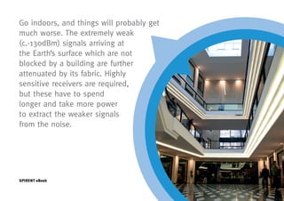
  • 9. Go indoors, and things will probably get much worse. The extremely weak (c.-130dBm) signals arriving at the Earths surface which are not blocked by a building are further attenuated by its fabric. Highly sensitive receivers are required, but these have to spend longer and take more power to extract the weaker signals from the noise. SPIRENT eBook
  • 10. Accuracy is another measure which is significantly affected. The satellite signals, even if they are not obscured, may be reflected, and take multiple paths to the receiver antenna, much longer than the direct path, causing false copies of the signals to arrive, late, at the receiver corrupting the PNT calculations. Even worse is the case where there is no line of sight signal, and the multi-path version is the only one the receiver sees. Because the receiver uses the satellites signals as radio tape-measures any distortion in the signals (e.g. time delay, phase error) will degrade the PNT solution accuracy. In the case of weak signals, a high sensitivity receiver may help, but they are more susceptible to multipath signals. SPIRENT eBook Page 10
  • 11. So, in practice, the continuously-available millimetric accuracy heralded at the start is rarely achieved, indeed, accuracy of several metres can be a challenge. Therefore it is clear that GNSS alone is not enough. We need to consider how to optimise its benefits and how to bring the four measures of performance up to acceptable levels for our application. This can only be achieved by augmenting GNSS. Adding another system or multiple systems alongside GNSS to help it, correct it or substitute for it is the practical way forward. Collectively, this approach is known as Hybrid Positioning, the big opportunity for performance improvement arising from the complementary nature of the strengths and weaknesses of the various technologies. In combination the technologies can perform better (more accurate, higher availability etc) than any of the technologies independently. Team work rather than competition is the way forward it seems! SPIRENT eBook Page 11
  • 12. The need for test. With so many potential issues, testing of GNSS navigation systems is essential. Spirent has been the leader in this field for over 25 years, and has solutions for testing receivers on all existing and planned GNSS systems, as well as new solutions for Hybrid Positioning. SPIRENT eBook Page 12
  • 13. Options: Sensors A modern smartphone contains an array of sensors incorporated for a number of purposes but all potentially available for positioning. MEMs gyros and accelerometers, barometric sensors and magnetometers all have a direct application in estimating position. The inertial sensors can be used in the estimation of position by sensing the movement of the body from a known initial position. In this way GNSS technology, which provides accurate positions but not all the time, and inertial technology which allows a position estimate to be advanced in the absence of any external signals, form a perfect partnership. The addition of magnetometers to provide heading and barometric sensors to provide height completes a very useful set of sensors. SPIRENT eBook Page 13
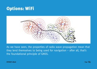
  • 14. Options: WiFi As we have seen, the properties of radio wave propagation mean that they lend themselves to being used for navigation after all, thats the foundational principle of GNSS. SPIRENT eBook Page 14
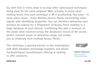
  • 15. So, with that in mind, what is to stop other radio-based techniques being used for the same purpose? Well, actually, in some cases nothing much. One such technique is Wi-Fi positioning. You have in most urban areas many Wireless Access Points transmitting radio signals with identifying properties. You can therefore determine your position by looking for a fingerprint of Access Point visibility in a large database of such devices. Combining this with a measure of the power level received versus the databases record of the access points transmit power to determine range, will enable you to trilaterate from multiple Access Points. This technique is gaining traction in the marketplace, with both database technology suppliers and phone handset/chipset manufacturers offering or looking Spirent GSS5700 Wi-Fi Access Point to offer solutions. Positioning Simulator SPIRENT eBook Page 15
  • 16. Spirent is the only test equipment provider to offer a Wi-Fi test solution. The GSS5700 Wi-Fi Access Point Positioning Simulator consists of a smart signal generator using a core application running on an internal CPU with touch-screen, remote MMI control via Ethernet. Access Point Control includes the ability to specify/ change, MAC address, SSID, TX channel power level/dynamic path loss and simulated visibility. Supporting up to 24 Access Points in one chassis, and being able to operate with Spirents GSS6700 GNSS simulators to give coherent GNSS/Wi-Fi test signals, makes the GSS5700 Wi-Fi Access Point Positioning Simulator an essential test solution for this positioning technology. SPIRENT eBook Page 16
  • 17. Options: Cellular What is Cellular Positioning? Cellular positioning utilizes the cellular network infrastructure to compute position and obtain a fast and coarse location estimate. Compared to A-GPS/A- GLONASS, cellular network positioning is generally faster (~5 seconds), but it is less accurate (50 meters to several kilometres). It is quite often used as fallback technology when GPS, GLONASS and Wi-Fi signals are unavailable. SPIRENT eBook Page 17
  • 18. Cell Identification (Cell-ID), the simplest location technology, locates a user based on the cell they are using, though the accuracy of this technique varies widely. Cell-ID positioning establishes the cell to which a user equipment (UE) is currently connected and uses that cell location as a rough estimate of the UE s current position. Ecell-ID positioning extends the Cell-ID positioning technique with supplementary information that narrows down the location within the cell where the UE is located. This supplementary information includes Timing advance and Neighbour cell measurements. Cellular network triangulation, either signal strength-based or time- based, can be used to improve accuracy and time-based methods such as Time Difference of Arrival are common. SPIRENT eBook Page 18
  • 19. Cellular positioning methods currently in use comprise: Cell identity (Cell-ID) positioning; Enhanced cell identity (Ecell-ID) positioning; Assisted Global Positioning System (A-GPS) positioning; Advanced Forward Link Trilateration (AFLT) in CDMA networks, Enhanced Observed Time Difference (E-OTD) in WCDMA networks and Uplink time difference of arrival (UTDOA) positioning. Observed downlink time difference of arrival (OTDOA) positioning technique is currently under discussion for LTE networks. SPIRENT eBook Page 19
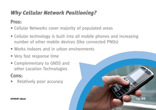
  • 20. Why Cellular Network Positioning? Pros: Cellular Networks cover majority of populated areas ellular technology is built into all mobile phones and increasing C number of other mobile devices (like connected PNDs) Works indoors and in urban environments Very fast response time omplementary to GNSS and C other Location Technologies Cons: Relatively poor accuracy SPIRENT eBook Page 20
  • 21. Even though all these techniques have some limitations, it is possible to use some as stand-alone or in conjunction with GNSS and other technologies to overcome the individual limitations. Considering the global scale and spread of cellular networks, cellular positioning would form an integral part of any hybrid strategy. SPIRENT eBook Page 21
  • 22. Other Sensors The complications faced by engineers aiming to meet the ever increasing requirements of emerging location based services (LBS) on accuracy and availability of positioning solutions mean looking for different and sometimes novel sources of positioning information. Use of cell-id techniques, Wi-Fi and other sensors such as low cost MEMs inertial are becoming more common and present unique test challenges. The GSS6400 rises to the challenge by enabling the user to record two channels of serial digital data alongside the digitized GNSS spectra. Signals direct from sensors or via a bus such as CANbus are captured and buried within the GNSS data ensuring coherent playback. An alternative use of this facility is to record a timing signal such as a GPS-derived 1pps which allows subsequent synchronization of external systems such as rate tables etc. SPIRENT eBook Page 22
  • 23. Comprehensive, End-to-End Location Technology Testing Spirents 8100 Location Technology is the evolution of the solution known for years as the Spirent ULTS. It offers the most advanced, comprehensive environment available for testing A-GPS/GLONASS- enabled GSM, UMTS and LTE devices. Location testing can be performed for standalone or hybrid location technology using A-GPS and A-GLONASS with Wi-Fi, Cell ID and ECID. This fully automated, flexible and configurable solution offers Control and User Plane implementations, including complete SUPL support. Spirent plays a major role in the development of test requirements and specifications for location technologies within leading standards organizations. SPIRENT eBook Page 23
  • 24. Blending a conclusion of sorts An unfortunate but inescapable conclusion is that whilst each technology has its strengths none are on their own sufficient to satisfy the accuracy, availability, integrity and cost requirements of the burgeoning location based services market. A combination of complementary technologies would appear to hold the answer but blending the approaches to get the best of each is a challenging technical task. Spirent aims to support this endeavour by drawing on its extensive experience and wide range of tools to provide bespoke test solutions for hybrid positioning developers. SPIRENT eBook Page 24
  • 25. We hope you found this Hybrid Positioning E-Book of interest. We are continually adding new content to our website on a regular basis. Bookmark this link: www.spirent.com/positioning Visit the Spirent GNSS Blog, there are currently more than 90 posts with 2 to 3 new posts added per week. Catch up on whats new: www.spirent.com/Blog/Positioning Need more information? gnss-solutions@spirent.com Share? Facebook LinkedIn Twitter Technorati Google Buzz Digg Delicious Reddit Stumbleupon MCD00185
  • 26. Spirent Spirent Federal Systems Got a smartphone? +44 1803 546325 +1 714 692 6565 Scan the QR globalsales@spirent.com info@spirentfederal.com Code for more www.spirent.com/positioning www.spirentfederal.com information