Ignite Dublin: Mapping Change: Changing Maps
Editor's Notes
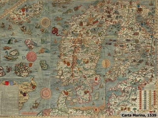
- #2: Maps from cartographyŌĆÖs ŌĆśGolden AgeŌĆÖ are works of art; owned and seen by the few, made by the even fewer.
- #3: As time marched on maps have become more ubiquitous, becoming part of the machinery of the state, such as this ŌĆśGriffith ValuationŌĆÖ map which was used for Tax gathering in Ireland 150 years ago.
- #4: The computer age has seen this process speed up immensely. Maps have always been out of date the minute theyŌĆÖre made, but production times have fallen massively.
- #5: And maps are everywhere now, thanks to the likes of Google. Google Maps wasnŌĆÖt necessarily hugely innovative, but Google took existing technologies and executed superbly.
- #6: We are now beginning to see real-time information on maps, everything from traffic like this map, or where your friends are from social networking services like FourSquare. And there are many other examples.
- #7: There are also many new sources of GeoData ŌĆō like geocoded Flickr photographs as shown here.
- #8: But maps are always changing. Particularly in our cities. Cities are engines of change.
- #9: Things get built, or not in this case of the Anglo Irish Bank HQ ŌĆō a poster child for the Celtic Tiger years.
- #10: But sometimes change is horrific, as in Haiti two years ago.
- #11: The earthquake killed 220,000 people, and prompted a huge humanitarian crisis.
- #12: Aid agencies swung into action. But they needed information about what was on the ground; where were the collapsed buildings, makeshift camps etc.
- #13: The kind of information that is shown on a map. But existing maps were poor, like this OpenStreetMap map of Port-au-Prince from the day before the earthquake.
- #14: The call went out to OSM contributors, satellite image providers and others: Help us improve the map.
- #15: Within two days, and after hundreds of editing sessions from across the globe, the map looked like this and continued to get much more detailed.
- #16: Apps were built or repurposed to allow those on the ground to use and improve the map data gathered by the community. Two way feedback was critical, and the maps became supremely useful in the short, medium and long term.
- #17: Because the data was very liberally licensed the issue of copyright wasnŌĆÖt a problem for the remixing and re-use of this data for medium and long-term planning in Haiti.
- #18: But liberally licensed data, and the kind of community that can be built around it has many other benefits. Mappers create richly detailed maps aimed at more than just motorists.
- #19: The data itself is regularly updated and kept current by the community.
- #20: New kinds of cartography are emerging. Indeed, the whole science of Geography is changing before our eyes.
- #21: Many of the initiatives springing up around OSM, like this OpenIrishMap, are very interesting and useful. I encourage you to check out OpenStreetMap.org.


