Kanada
Download as pptx, pdf0 likes4,707 views

EKF - TTK - TengerentÚli fÃķldrÃĐszek tÃĄrsadalomfÃķldrajza ÃģrÃĄra kÃĐszÞlt


Kanada
- 1. Kanada âA Mari Usque Ad Mareâ - tengertÅl tengerig Tolnai DÃģra
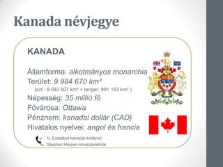
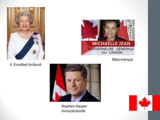
- 2. Kanada nÃĐvjegye KANADA Ãllamforma: alkotmÃĄnyos monarchia TerÞlet: 9 984 670 kmÂē (szf.: 9 093 507 kmÂē + tenger: 891 163 kmÂē ) NÃĐpessÃĐg: 35 milliÃģ fÅ FÅvÃĄrosa: Ottawa PÃĐnznem: kanadai dollÃĄr (CAD) Hivatalos nyelvei: angol ÃĐs francia II. ErzsÃĐbet kanadai kirÃĄlynÅ Stephen Harper miniszterelnÃķk
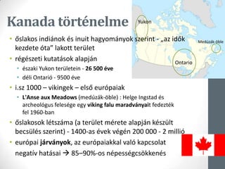
- 4. Kanada tÃķrtÃĐnelme âĒ Åslakos indiÃĄnok ÃĐs inuit hagyomÃĄnyok szerint - âaz idÅk kezdete Ãģtaâ lakott terÞlet âĒ rÃĐgÃĐszeti kutatÃĄsok alapjÃĄn âĒ ÃĐszaki Yukon terÞletein - 26 500 ÃĐve âĒ dÃĐli OntariÃģ - 9500 ÃĐve âĒ i.sz 1000 â vikingek â elsÅ eurÃģpaiak âĒ L'Anse aux Meadows (medÚzÃĄk-Ãķble) : Helge Ingstad ÃĐs archeolÃģgus felesÃĐge egy viking falu maradvÃĄnyait fedeztÃĐk fel 1960-ban âĒ Åslakosok lÃĐtszÃĄma (a terÞlet mÃĐrete alapjÃĄn kÃĐszÞlt becsÞlÃĐs szerint) - 1400-as ÃĐvek vÃĐgÃĐn 200 000 - 2 milliÃģ âĒ eurÃģpai jÃĄrvÃĄnyok, az eurÃģpaiakkal valÃģ kapcsolat negatÃv hatÃĄsai ï 85â90%-os nÃĐpessÃĐgcsÃķkkenÃĐs Yukon Ontario MedÚzÃĄk-Ãķble
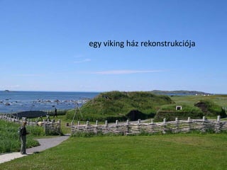
- 5. Kanada tÃķrtÃĐnelme forrÃĄs : www.wikipedia.hu forrÃĄs : www.wikipedia.hu L'Anse aux Meadows TÃķrtÃĐnelmi Nemzeti Park egy viking hÃĄz rekonstrukciÃģja
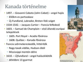
- 6. Kanada tÃķrtÃĐnelme âĒ 1497. â Giovanni Caboto (John Cabot) â angol hajÃģs âĒ 650km-es partszakasz âĒ Ãj-Fundland, Labrador, Breton-foki-sziget âĒ 1534-1542. â Jacques Cartier â francia felfedezÅ âĒ 1603. â Samuel de Champlain â elsÅ ÃĄllandÃģ eurÃģpai telepÞlÃĐsek âĒ 1605. Port Royal â Acadia fÅvÃĄrosa âĒ 1608. QuÃĐbec â Kanada fÅvÃĄrosa âĒ francia szÅrmekereskedÅk, hittÃĐrÃtÅk âĒ Nagy-tavak vidÃĐke, Hudson-ÃķbÃķl âĒ Mississippi mentÃĐn dÃĐlre âĒ 1610. â Ãjfundland â angol halÃĄszkikÃķtÅk âĒ dÃĐlebbre 13 gyarmat
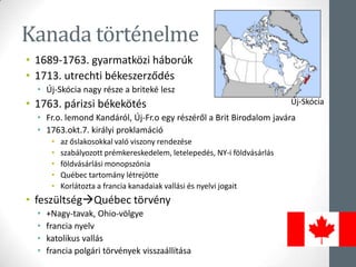
- 7. Kanada tÃķrtÃĐnelme âĒ 1689-1763. gyarmatkÃķzi hÃĄborÚk âĒ 1713. utrechti bÃĐkeszerzÅdÃĐs âĒ Ãj-SkÃģcia nagy rÃĐsze a britekÃĐ lesz âĒ 1763. pÃĄrizsi bÃĐkekÃķtÃĐs âĒ Fr.o. lemond KandÃĄrÃģl, Ãj-Fr.o egy rÃĐszÃĐrÅl a Brit Birodalom javÃĄra âĒ 1763.okt.7. kirÃĄlyi proklamÃĄciÃģ âĒ az Åslakosokkal valÃģ viszony rendezÃĐse âĒ szabÃĄlyozott prÃĐmkereskedelem, letelepedÃĐs, NY-i fÃķldvÃĄsÃĄrlÃĄs âĒ fÃķldvÃĄsÃĄrlÃĄsi monopszÃģnia âĒ QuÃĐbec tartomÃĄny lÃĐtrejÃķtte âĒ KorlÃĄtozta a francia kanadaiak vallÃĄsi ÃĐs nyelvi jogait âĒ feszÞltsÃĐgï QuÃĐbec tÃķrvÃĐny âĒ +Nagy-tavak, Ohio-vÃķlgye âĒ francia nyelv âĒ katolikus vallÃĄs âĒ francia polgÃĄri tÃķrvÃĐnyek visszaÃĄllÃtÃĄsa Ãj-SkÃģcia
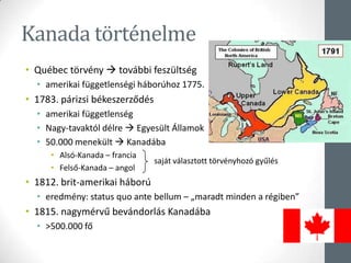
- 8. Kanada tÃķrtÃĐnelme âĒ QuÃĐbec tÃķrvÃĐny ï tovÃĄbbi feszÞltsÃĐg âĒ amerikai fÞggetlensÃĐgi hÃĄborÚhoz 1775. âĒ 1783. pÃĄrizsi bÃĐkeszerzÅdÃĐs âĒ amerikai fÞggetlensÃĐg âĒ Nagy-tavaktÃģl dÃĐlre ï EgyesÞlt Ãllamok âĒ 50.000 menekÞlt ï KanadÃĄba âĒ AlsÃģ-Kanada â francia âĒ FelsÅ-Kanada â angol âĒ 1812. brit-amerikai hÃĄborÚ âĒ eredmÃĐny: status quo ante bellum â âmaradt minden a rÃĐgibenâ âĒ 1815. nagymÃĐrvÅą bevÃĄndorlÃĄs KanadÃĄba âĒ >500.000 fÅ sajÃĄt vÃĄlasztott tÃķrvÃĐnyhozÃģ gyÅąlÃĐs
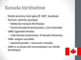
- 9. Kanada tÃķrtÃĐnelme âĒ felelÅs kormÃĄny irÃĄnti igÃĐnyï 1837. lÃĄzadÃĄsok âĒ Durham- jelentÃĐs javaslatai âĒ felelÅs kormÃĄnyzat lÃĐtrehozÃĄsa âĒ francia kanadaiak beolvasztÃĄsa a brit kultÚrÃĄba âĒ 1840. EgyesÃtÃĐsi tÃķrvÃĐny âĒ a kÃĐt Kanada ÃķsszevonÃĄsa ï Kanada TartomÃĄny âĒ 1846. oregoni szerzÅdÃĐs âĒ hatÃĄrkiterjesztÃĐs â Vancouver irÃĄnyÃĄba âĒ 1849-re az Ãķsszes brit tartomÃĄnyban van felelÅs kormÃĄnyzat
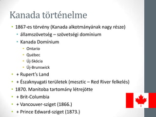
- 10. Kanada tÃķrtÃĐnelme âĒ 1867-es tÃķrvÃĐny (Kanada alkotmÃĄnyÃĄnak nagy rÃĐsze) âĒ ÃĄllamszÃķvetsÃĐg â szÃķvetsÃĐgi domÃnium âĒ Kanada DomÃnium âĒ Ontario âĒ QuÃĐbec âĒ Ãj-SkÃģcia âĒ Ãj-Brunswick âĒ + Rupertâs Land âĒ + Ãszaknyugati terÞletek (mesztic â Red River felkelÃĐs) âĒ 1870. Manitoba tartomÃĄny lÃĐtrejÃķtte âĒ + Brit-Columbia âĒ + Vancouver-sziget (1866.) âĒ + Prince Edward-sziget (1873.)
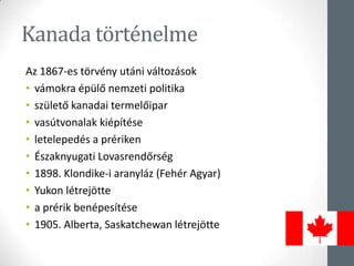
- 11. Kanada tÃķrtÃĐnelme Az 1867-es tÃķrvÃĐny utÃĄni vÃĄltozÃĄsok âĒ vÃĄmokra ÃĐpÞlÅ nemzeti politika âĒ szÞletÅ kanadai termelÅipar âĒ vasÚtvonalak kiÃĐpÃtÃĐse âĒ letelepedÃĐs a prÃĐriken âĒ Ãszaknyugati LovasrendÅrsÃĐg âĒ 1898. Klondike-i aranylÃĄz (FehÃĐr Agyar) âĒ Yukon lÃĐtrejÃķtte âĒ a prÃĐrik benÃĐpesÃtÃĐse âĒ 1905. Alberta, Saskatchewan lÃĐtrejÃķtte
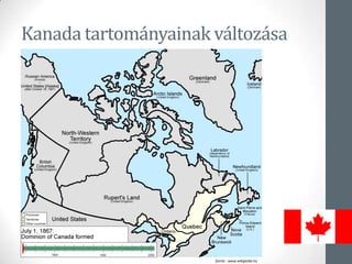
- 12. Kanada tartomÃĄnyainak vÃĄltozÃĄsa forrÃĄs : www.wikipedia.hu
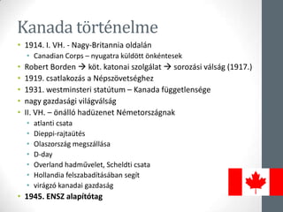
- 13. Kanada tÃķrtÃĐnelme âĒ 1914. I. VH. - Nagy-Britannia oldalÃĄn âĒ Canadian Corps â nyugatra kÞldÃķtt ÃķnkÃĐntesek âĒ Robert Borden ï kÃķt. katonai szolgÃĄlat ï sorozÃĄsi vÃĄlsÃĄg (1917.) âĒ 1919. csatlakozÃĄs a NÃĐpszÃķvetsÃĐghez âĒ 1931. westminsteri statÚtum â Kanada fÞggetlensÃĐge âĒ nagy gazdasÃĄgi vilÃĄgvÃĄlsÃĄg âĒ II. VH. â ÃķnÃĄllÃģ hadÞzenet NÃĐmetorszÃĄgnak âĒ atlanti csata âĒ Dieppi-rajtaÞtÃĐs âĒ OlaszorszÃĄg megszÃĄllÃĄsa âĒ D-day âĒ Overland hadmÅąvelet, Scheldti csata âĒ Hollandia felszabadÃtÃĄsÃĄban segÃt âĒ virÃĄgzÃģ kanadai gazdasÃĄg âĒ 1945. ENSZ alapÃtÃģtag
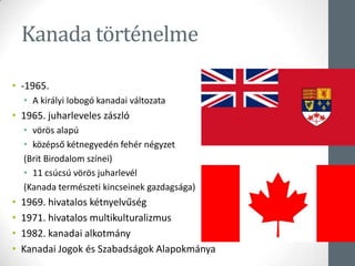
- 14. Kanada tÃķrtÃĐnelme âĒ -1965. âĒ A kirÃĄlyi lobogÃģ kanadai vÃĄltozata âĒ 1965. juharleveles zÃĄszlÃģ âĒ vÃķrÃķs alapÚ âĒ kÃķzÃĐpsÅ kÃĐtnegyedÃĐn fehÃĐr nÃĐgyzet (Brit Birodalom szÃnei) âĒ 11 csÚcsÚ vÃķrÃķs juharlevÃĐl (Kanada termÃĐszeti kincseinek gazdagsÃĄga) âĒ 1969. hivatalos kÃĐtnyelvÅąsÃĐg âĒ 1971. hivatalos multikulturalizmus âĒ 1982. kanadai alkotmÃĄny âĒ Kanadai Jogok ÃĐs SzabadsÃĄgok AlapokmÃĄnya
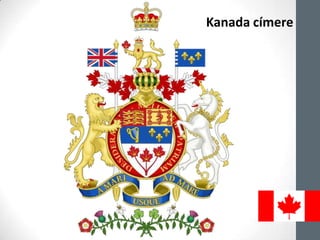
- 15. Kanada cÃmere
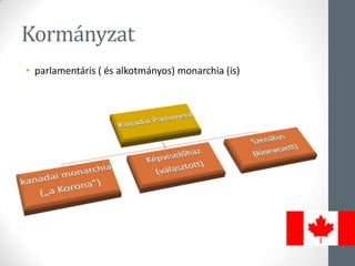
- 16. KormÃĄnyzat âĒ parlamentÃĄris ( ÃĐs alkotmÃĄnyos) monarchia (is)
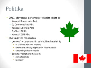
- 17. Politika âĒ 2011. szÃķvetsÃĐgi parlament â Ãķt pÃĄrt jutott be âĒ Kanadai KonzervatÃv PÃĄrt âĒ Ãj Demokratikus PÃĄrt âĒ Kanadai LiberÃĄlis PÃĄrt âĒ QuÃĐbeci Blokk âĒ Kanadai ZÃķld PÃĄrt âĒ alkotmÃĄnyos monarchia âĒ âKoronaâ â ceremoniÃĄlis, szimbolikus hatalmi ÃĄg âĒ II. ErzsÃĐbet kanadai kirÃĄlynÅ âĒ kinevezett alkirÃĄlyi kÃĐpviselÅ = fÅkormÃĄnyzÃģ âĒ tartomÃĄnyi alkormÃĄnyzÃģk âĒ politikai vÃĐgrehajtÃģ hatalom âĒ miniszterelnÃķk âĒ kormÃĄny
- 18. fÅkormÃĄnyzÃģ II. ErzsÃĐbet kirÃĄlynÅ Stephen Harper miniszterelnÃķk
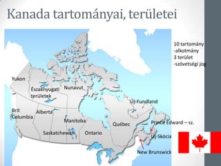
- 19. Kanada tartomÃĄnyai, terÞletei Yukon Ãszaknyugati terÞletek Nunavut Brit Columbia Alberta Saskatchewan Manitoba Ontario QuÃĐbec Ãj-Fundland Ãj-SkÃģcia Prince Edward â sz. New Brunswick 10 tartomÃĄny -alkotmÃĄny 3 terÞlet -szÃķvetsÃĐgi jog
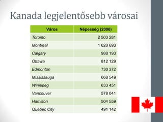
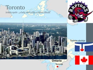
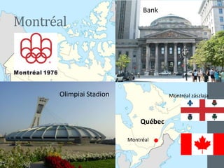
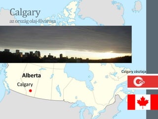
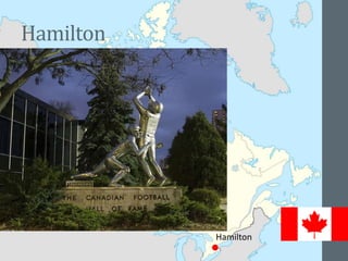
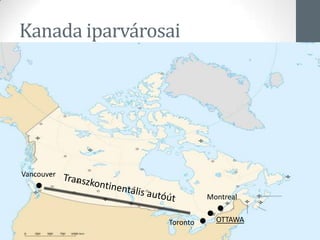
- 21. Kanada legjelentÅsebb vÃĄrosai VÃĄros NÃĐpessÃĐg (2006) Toronto 2 503 281 Montreal 1 620 693 Calgary 988 193 Ottawa 812 129 Edmonton 730 372 Mississauga 668 549 Winnipeg 633 451 Vancouver 578 041 Hamilton 504 559 QuÃĐbec City 491 142
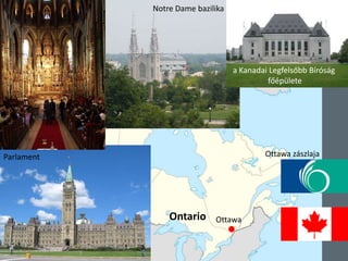
- 25. Ottawa huronnyelv:kereskedÅhely Parlament Ottawa Notre Dame bazilika a Kanadai LegfelsÅbb BÃrÃģsÃĄg fÅÃĐpÞlete Ottawa zÃĄszlaja Ontario
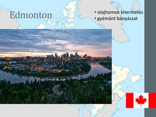
- 26. Edmonton Edmonton Alberta âĒ olajhomok kitermelÃĐs âĒ gyÃĐmÃĄnt bÃĄnyÃĄszat
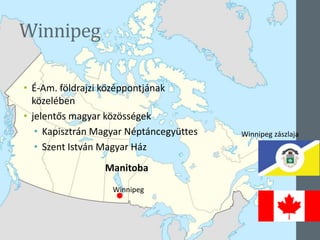
- 28. Winnipeg âĒ Ã-Am. fÃķldrajzi kÃķzÃĐppontjÃĄnak kÃķzelÃĐben âĒ jelentÅs magyar kÃķzÃķssÃĐgek âĒ KapisztrÃĄn Magyar NÃĐptÃĄncegyÞttes âĒ Szent IstvÃĄn Magyar HÃĄz Winnipeg Winnipeg zÃĄszlaja Manitoba
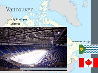
- 29. Vancouver âĒ szolgÃĄltatÃģipar âĒ turizmus Vancouver Brit Columbia Vancouver zÃĄszlaja
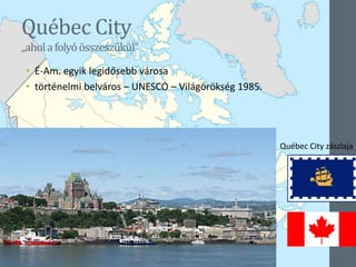
- 31. QuÃĐbec City âaholafolyÃģÃķsszeszÅąkÞlâ âĒ Ã-Am. egyik legidÅsebb vÃĄrosa âĒ tÃķrtÃĐnelmi belvÃĄros â UNESCO â VilÃĄgÃķrÃķksÃĐg 1985. QuÃĐbec City QuÃĐbec QuÃĐbec City zÃĄszlaja
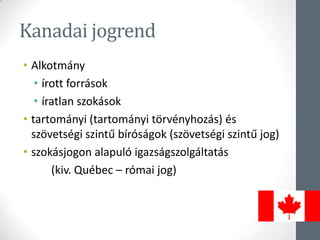
- 32. Kanadai jogrend âĒ AlkotmÃĄny âĒ Ãrott forrÃĄsok âĒ Ãratlan szokÃĄsok âĒ tartomÃĄnyi (tartomÃĄnyi tÃķrvÃĐnyhozÃĄs) ÃĐs szÃķvetsÃĐgi szintÅą bÃrÃģsÃĄgok (szÃķvetsÃĐgi szintÅą jog) âĒ szokÃĄsjogon alapulÃģ igazsÃĄgszolgÃĄltatÃĄs (kiv. QuÃĐbec â rÃģmai jog)
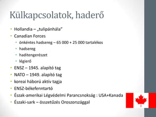
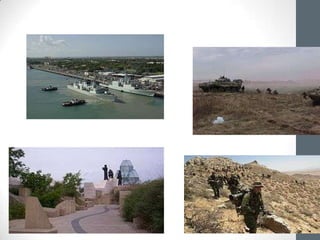
- 33. KÞlkapcsolatok, haderÅ âĒ Hollandia â âtulipÃĄnhÃĄlaâ âĒ Canadian Forces âĒ ÃķnkÃĐntes hadsereg â 65 000 + 25 000 tartalÃĐkos âĒ hadsereg âĒ haditengerÃĐszet âĒ lÃĐgierÅ âĒ ENSZ â 1945. alapÃtÃģ tag âĒ NATO â 1949. alapÃtÃģ tag âĒ koreai hÃĄborÚ aktÃv tagja âĒ ENSZ-bÃĐkefenntartÃģ âĒ Ãszak-amerikai LÃĐgvÃĐdelmi ParancsnoksÃĄg : USA+Kanada âĒ Ãszaki-sark â ÃķsszetÅązÃĐs °ŋ°ųīĮēõģúīĮ°ųēõģúÃĄēĩgal
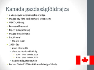
- 35. Kanada gazdasÃĄgfÃķldrajza âĒ a vilÃĄg egyik leggazdagabb orszÃĄga âĒ magas egy fÅre jutÃģ nemzeti jÃķvedelem âĒ OECD-, G8-tag âĒ kereskedÅnemzet âĒ fejlett piacgazdasÃĄg âĒ magas ÃĐletszÃnvonal âĒ impÅrterei âĒ US, UK, JapÃĄn âĒ 1990. Ãģta âĒ gyors nÃķvekedÃĐs âĒ alacsony munkanÃĐlkÞlisÃĐg âĒ 5,9% - teljes Kanada, 2008 âĒ 8,6% - teljes Kanada, 2009 âĒ nagy kÃķltsÃĐgvetÃĐsi szuficit âĒ Forbes Global 2000 â 69 kanadai cÃĐg â 5.hely
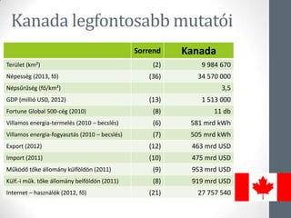
- 36. Kanada legfontosabb mutatÃģi Sorrend Kanada TerÞlet (kmÂē) (2) 9 984 670 NÃĐpessÃĐg (2013, fÅ) (36) 34 570 000 NÃĐpsÅąrÅąsÃĐg (fÅ/kmÂē) 3,5 GDP (milliÃģ USD, 2012) (13) 1 513 000 Fortune Global 500-cÃĐg (2010) (8) 11 db Villamos energia-termelÃĐs (2010 â becslÃĐs) (6) 581 mrd kWh Villamos energia-fogyasztÃĄs (2010 â becslÃĐs) (7) 505 mrd kWh Export (2012) (12) 463 mrd USD Import (2011) (10) 475 mrd USD MÅąkÃķdÅ tÅke ÃĄllomÃĄny kÞlfÃķldÃķn (2011) (9) 953 mrd USD KÞlf.-i mÅąk. tÅke ÃĄllomÃĄny belfÃķldÃķn (2011) (8) 919 mrd USD Internet â hasznÃĄlÃģk (2012, fÅ) (21) 27 757 540
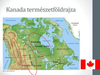
- 37. Kanada termÃĐszetfÃķldrajza forrÃĄs : www.terkepek.net Kanadai - ÅsfÃķld
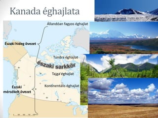
- 38. forrÃĄs : www.wikipedia.hu Kanada ÃĐghajlata Ãszaki hideg Ãķvezet Ãszaki mÃĐrsÃĐkelt Ãķvezet ÃllandÃģan fagyos ÃĐghajlat Tundra ÃĐghajlat Tajga ÃĐghajlat KontinentÃĄlis ÃĐghajlat forrÃĄs : www.wikipedia.hu
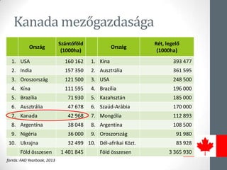
- 39. Kanada mezÅgazdasÃĄga OrszÃĄg SzÃĄntÃģfÃķld (1000ha) OrszÃĄg RÃĐt, legelÅ (1000ha) 1. USA 160 162 1. °ÃēÔēđ 393 477 2. India 157 350 2. AusztrÃĄlia 361 595 3. °ŋ°ųīĮēõģúīĮ°ųēõģúÃĄēĩ 121 500 3. USA 248 500 4. °ÃēÔēđ 111 595 4. BrazÃlia 196 000 5. BrazÃlia 71 930 5. KazahsztÃĄn 185 000 6. AusztrÃĄlia 47 678 6. SzaÚd-ArÃĄbia 170 000 7. Kanada 42 968 7. MongÃģlia 112 893 8. ArgentÃna 38 048 8. ArgentÃna 108 500 9. NigÃĐria 36 000 9. °ŋ°ųīĮēõģúīĮ°ųēõģúÃĄēĩ 91 980 10. Ukrajna 32 499 10. DÃĐl-afrikai KÃķzt. 83 928 FÃķld Ãķsszesen 1 401 845 FÃķld Ãķsszesen 3 365 930 forrÃĄs: FAO Yearbook, 2013
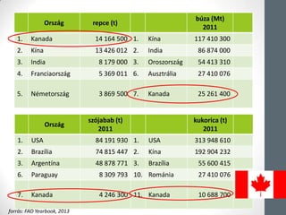
- 40. OrszÃĄg repce (t) bÚza (Mt) 2011 1. Kanada 14 164 500 1. °ÃēÔēđ 117 410 300 2. °ÃēÔēđ 13 426 012 2. India 86 874 000 3. India 8 179 000 3. °ŋ°ųīĮēõģúīĮ°ųēõģúÃĄēĩ 54 413 310 4. đó°ųēđēÔģĶūąēđīĮ°ųēõģúÃĄēĩ 5 369 011 6. AusztrÃĄlia 27 410 076 5. NÃĐmetorszÃĄg 3 869 500 7. Kanada 25 261 400 OrszÃĄg szÃģjabab (t) 2011 kukorica (t) 2011 1. USA 84 191 930 1. USA 313 948 610 2. BrazÃlia 74 815 447 2. °ÃēÔēđ 192 904 232 3. ArgentÃna 48 878 771 3. BrazÃlia 55 600 415 6. Paraguay 8 309 793 10. RomÃĄnia 27 410 076 7. Kanada 4 246 300 11. Kanada 10 688 700 forrÃĄs: FAO Yearbook, 2013
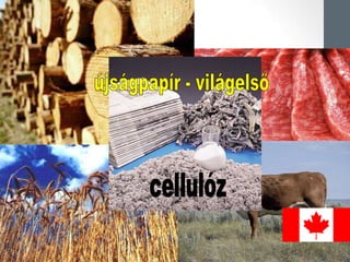
- 43. Kanada ÃĐs a juharszirup
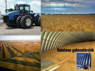
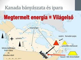
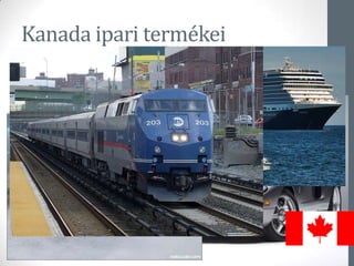
- 44. Kanada bÃĄnyÃĄszata ÃĐs ipara vasÃĐrc Kanadai-pajzs kÅolaj ÃĐs fÃķldgÃĄz PrÃĐri-tÃĄbla ÃĐs Alaszkai-ÃķbÃķl VÃzenergia urÃĄnÃĐrc bauxit DÃĐl-AmerikÃĄbÃģl szÃnesfÃĐm-kohÃĄszat
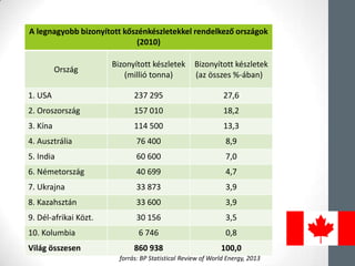
- 45. A legnagyobb bizonyÃtott kÅszÃĐnkÃĐszletekkel rendelkezÅ orszÃĄgok (2010) OrszÃĄg BizonyÃtott kÃĐszletek (milliÃģ tonna) BizonyÃtott kÃĐszletek (az Ãķsszes %-ÃĄban) 1. USA 237 295 27,6 2. °ŋ°ųīĮēõģúīĮ°ųēõģúÃĄēĩ 157 010 18,2 3. °ÃēÔēđ 114 500 13,3 4. AusztrÃĄlia 76 400 8,9 5. India 60 600 7,0 6. NÃĐmetorszÃĄg 40 699 4,7 7. Ukrajna 33 873 3,9 8. KazahsztÃĄn 33 600 3,9 9. DÃĐl-afrikai KÃķzt. 30 156 3,5 10. Kolumbia 6 746 0,8 VilÃĄg Ãķsszesen 860 938 100,0 forrÃĄs: BP Statistical Review of World Energy, 2013
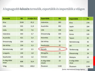
- 46. AlegnagyobbkÅszÃĐntermelÅk,exportÃĄlÃģkÃĐsimportÃĄlÃģkavilÃĄgon TermelÅk Mt A teljes %-a °ÃēÔēđ 3549 45,3 USA 935 11,9 India 595 7,6 IndonÃĐzia 443 5,7 AusztrÃĄlia 421 5,4 °ŋ°ųīĮēõģúīĮ°ųēõģúÃĄēĩ 354 4,5 DÃĐl-Afrika 259 3,3 NÃĐmetorszÃĄg 197 2,5 Lengyelo. 144 1,8 KazahsztÃĄn 126 1,6 A vilÃĄg tÃķbbi rÃĐsze 808 10,4 VilÃĄg 7831 100,0 ExportÃĄlÃģk Mt IndonÃĐzia 383 AusztrÃĄlia 302 USA 106 °ŋ°ųīĮēõģúīĮ°ųēõģúÃĄēĩ 103 Kolumbia 82 DÃĐl-Afrika 72 KazahsztÃĄn 32 Kanada 25 MongÃģlia 22 VietnÃĄm 18 A vilÃĄg tÃķbbi rÃĐszÃĐn 23 Ãsszesen 1168 ImportÃĄlÃģk Mt °ÃēÔēđ 278 JapÃĄn 184 India 158 Korea 126 Tajvan 65 NÃĐmetorszÃĄg 45 UK 44 TÃķrÃķkorszÃĄg 29 OlaszorszÃĄg 24 Malajzia 22 A vilÃĄg tÃķbbi rÃĐsze 213 Ãsszesen 1188 forrÃĄs: International Energy Agency
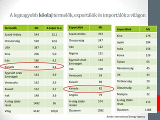
- 47. AlegnagyobbkÅolajtermelÅk,exportÃĄlÃģkÃĐsimportÃĄlÃģkavilÃĄgon TermelÅk Mt A teljes %-a SzaÚd-ArÃĄbia 544 13,1 °ŋ°ųīĮēõģúīĮ°ųēõģúÃĄēĩ 520 12,6 USA 387 9,3 °ÃēÔēđ 206 5,0 IrÃĄn 186 4,5 Kanada 182 4,4 EgyesÞlt Arab EmÃrsÃĐgek 163 3,9 Venezuela 162 3,9 Kuwait 152 3,7 Irak 148 3,6 A vilÃĄg tÃķbbi rÃĐsze 1492 36 VilÃĄg 4142 100,0 ExportÃĄlÃģk Mt SzaÚd-ArÃĄbia 353 °ŋ°ųīĮēõģúīĮ°ųēõģúÃĄēĩ 247 IrÃĄn 122 NigÃĐria 121 EgyesÞlt Arab EmÃrsÃĐgek 114 Irak 108 Venezuela 93 Kuwait 89 Kanada 82 Angola 79 A vilÃĄg tÃķbbi rÃĐszÃĐn 574 Ãsszesen 1982 ImportÃĄlÃģk Mt °ÃēÔēđ 278 JapÃĄn 184 India 158 Korea 126 Tajvan 65 NÃĐmetorszÃĄg 45 UK 44 TÃķrÃķkorszÃĄg 29 OlaszorszÃĄg 24 Malajzia 22 A vilÃĄg tÃķbbi rÃĐsze 213 Ãsszesen 1188 forrÃĄs: International Energy Agency
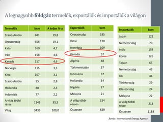
- 48. AlegnagyobbfÃķldgÃĄztermelÅk,exportÃĄlÃģkÃĐsimportÃĄlÃģkavilÃĄgon TermelÅk bcm A teljes %-a SzaÚd-ArÃĄbia 681 19,8 °ŋ°ųīĮēõģúīĮ°ųēõģúÃĄēĩ 656 19,1 Katar 160 4,7 IrÃĄn 158 4,6 Kanada 157 4,6 NorvÃĐgia 115 3,3 °ÃēÔēđ 107 3,1 SzaÚd-ArÃĄbia 95 2,8 Hollandia 80 2,3 IndonÃĐzia 77 2,2 A vilÃĄg tÃķbbi rÃĐsze 1149 33,5 VilÃĄg 3435 100,0 ExportÃĄlÃģk bcm °ŋ°ųīĮēõģúīĮ°ųēõģúÃĄēĩ 185 Katar 120 NorvÃĐgia 109 Kanada 57 AlgÃĐria 48 TÞrkmenisztÃĄn 37 IndonÃĐzia 37 Hollandia 34 NigÃĐria 27 Malajzia 21 A vilÃĄg tÃķbbi rÃĐszÃĐn 154 Ãsszesen 829 ImportÃĄlÃģk bcm JapÃĄn 122 NÃĐmetorszÃĄg 70 India 158 Korea 126 Tajvan 65 NÃĐmetorszÃĄg 45 UK 44 TÃķrÃķkorszÃĄg 29 OlaszorszÃĄg 24 Malajzia 22 A vilÃĄg tÃķbbi rÃĐsze 213 Ãsszesen 1188 forrÃĄs: International Energy Agency
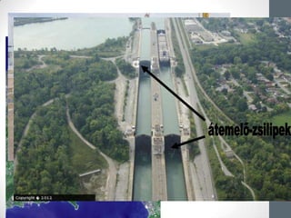
- 51. A Welland-csatorna âĒErie ÃĐs Ontario-tÃģ kÃķzÃķtt âĒ100 mÃĐteres szintkÞlÃķnbsÃĐget hidal ÃĄt âĒkikerÞli a NiagarÃĄt âĒtengerjÃĄrÃģk jutnak fel a Nagy-Tavakig âĒ44 kilomÃĐter hosszÚ âĒ27 zsilipe van
- 52. TermÃĐszeti vilÃĄgÃķrÃķksÃĐg âĒ Nahanni Nemzeti Park âĒ Dinoszaurusz TartomÃĄnyi Park âĒ Wood Buffalo Nemzeti Park âĒ A kanadai SziklÃĄs-hegysÃĐg nemzeti ÃĐs tartomÃĄnyi parkjai âĒ Gros Morne Nemzeti Park âĒ Joggins-szirtek âĒ Miguasha Nemzeti Park
- 53. FelhasznÃĄlt irodalom âĒ ProbÃĄld F. (szerk.) 2004: Amerika regionÃĄlis fÃķldrajza. â Trefort KiadÃģ, Budapest, 360 p. âĒ Miskolci Egyetem â VilÃĄg tÃĄrsadalomfÃķldrajza â jegyzet âĒ Csimax â Kanada fÃķldrajza â prezentÃĄciÃģ âĒ http://www.fao.org/docrep/018/i3107e/i3107e00.htm âĒ http://hu.wikipedia.org/wiki/Kanada_f%C3%B6ldrajza âĒ http://hu.wikipedia.org/wiki/Kanada âĒ http://www.slmc.uottawa.ca/?q=constitutional_act_1791 âĒ http://www.seetorontonow.com/ âĒ http://www.niagaraparks.com/niagara-falls- attractions/journey-behind-the-falls.html âĒ http://www.canadainternational.gc.ca/hungary- hongrie/index.aspx?lang=hun