Lab report 5 vector analysis
ŌĆóDownload as DOCX, PDFŌĆó
1 likeŌĆó215 views

This presentation focuses on Creation of vector analysis in Arcgis of a particular area A geographic information system (GIS) is a system designed to capture, store, manipulate, analyze, manage, and present spatial or geographic data.


Lab report 5 vector analysis
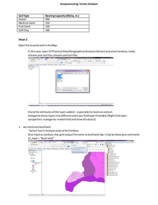
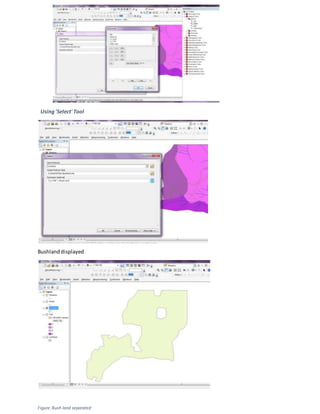
- 1. Geoprocessing: Vector Analysis . Soil Type Bearing Capacity (kN/sq. m.) Gravel 450 MediumSand 250 Fine Sand 150 SoftClay 100 Steps:1 Openfile toworkwithinArcMap. In thiscase, openD:/Practical Data/Geographical Analysis(Vector)andselectlanduse,roads, streamsand soil files streamsandsoil files. Checkthe attributesof the layersadded ŌĆō especiallyforlanduse andsoil. Categorize these layersintodifferentcolorsperfieldtype if needed.(Rightclicklayer- >properties->categories->selectfieldandshow all values) 1. we needonlybushland. ŌĆśSelectŌĆÖtool inAnalysistoolsof ArcToolbox. Give inputas Landuse.shp,giveoutputfilename asbushland.shp.inSql window,give command LU_type = ŌĆ£Bush landŌĆØ
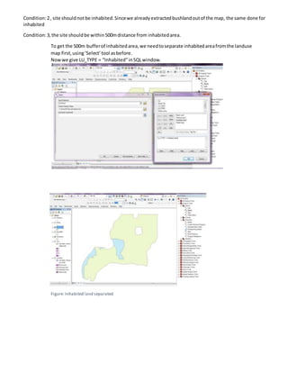
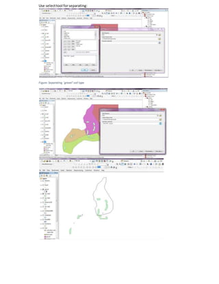
- 3. Condition:2, site shouldnotbe inhabited.Sincewe alreadyextractedbushlandoutof the map, the same done for inhabited Condition:3,the site shouldbe within500mdistance from inhabitedarea. To get the 500m bufferof inhabitedarea,we needtoseparate inhabitedareafromthe landuse map first,usingŌĆśSelectŌĆÖtool asbefore. Nowwe give LU_TYPE = ŌĆ£InhabitedŌĆØinSQLwindow. Figure: Inhabited land separated
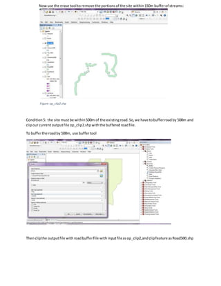
- 4. Afterseparatinginhabitedarea,bufferthe inhabitedareaby500m. To selectsite within500mbufferof inhabitedarea,use clip tool with: Inputfile asŌĆśbushland.shpŌĆÖ,Clipfeature asŌĆśinhabited500.shpŌĆÖ andoutputfile asop_clip1.shp Figure: Op_clip1.shp Condition 4:our site mustnot be within150m of streams. For this,we have to bufferstreamsby150m. Then use the erase tool to remove the portionsof the site (op_clip1.shp) thatintersectswiththe bufferedstreamfile.
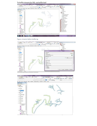
- 5. To bufferstreamsby150, use buffertool Figure: streams before buffering
- 6. Nowuse the erase tool to remove the portionsof the site within150m bufferof streams: Figure:op_clip2.shp Condition 5: the site mustbe within500m of the existingroad.So,we have tobufferroadby 500m and clipour currentoutputfile op_clip2.shpwiththe bufferedroadfile. To bufferthe roadby 500m, use buffertool Thenclipthe outputfile withroadbufferfile withinputfileasop_clip2,andclipfeature asRoad500.shp
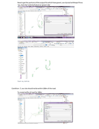
- 7. Outputfile isnamedasop_clip3.shp Figure: op_clip3.shp Condition6:To get siteswithgravel only,we have tofirstseparate gravel fromothersoil typesinthe map.
- 8. Use selecttool forseparating: Figure:Separating 'gravel' soil type
- 9. Nowto getthe portionsof the outputfile whichhave gravel,use cliptool withInputfileas ŌĆśop_clip3.shpŌĆÖandclipfeature asŌĆśgravel.shpŌĆÖ Figure:op_clip4.shp Condition:7, our site should notbe within100m of the road. To create bufferof road for 100m:
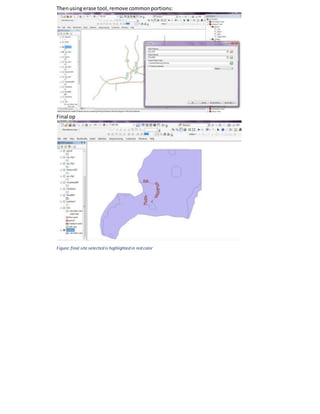
- 10. Thenusingerase tool,remove commonportions: Final op Figure:final site selected is highlighted in red color