Layar and tourism & travel industry
Download as pptx, pdf1 like1,016 views

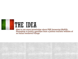
This document describes how to build a geolayer for a touristic website of an Italian medieval village using knowledge of PHP, JavaScript, MySQL, and Photoshop. It involves extracting information like descriptions, images, audio guides, and coordinates from the website's Joomla and K2 components to create geo-located points of interest that can be viewed on mobile devices through augmented reality. The geolayer allows users to search for points of interest, view more details like elevation and linked web pages, and listen to audio guides to enhance their visit to the village.
1 of 18
Download to read offline


Ad
Recommended
Website Implementation #2
Website Implementation #2shannon-newton
?
The document provides step-by-step instructions for designing a website background, header, navigation bar, footer, pages, and adding social media links. It describes changing colors, fonts, images, and layout. Key sections include customizing the background image, changing the header font and size, adding new pages like "News" and "Lyrics", designing the navigation bar and footer to be consistent and contain links to pages and social media, and outlining each page will have content within a semi-transparent grey box.Website implementation
Website implementationjmkyang
?
The document provides details about customizing and implementing a website for a fictional band called Bloc Party. Key points:
- The author customized the website palette to achieve a deep red theme with black accents.
- Images of the band were edited to remove backgrounds and enhance quality.
- Based on research, an "About" page was replaced with a "News" page to keep fans updated.
- Social media feeds from the real Bloc Party accounts were linked to give the site more authenticity.
- Audio and video content from fake Bloc Party albums and performances were added.
- Contact information and fake tour dates/venues were included to complete the band website.Feedback on product
Feedback on productEm St
?
The document provides feedback on the front cover, contents page, and double page spread of a product. For the front cover, testers preferred removing the barcode, using a warmer color for the masthead, and an image showing more personality. They also liked the navy gradient background better than a solid color. For the contents page, testers thought the font contrasts and layout looked good but the silhouette could be repositioned. They suggested including a website link. For the double page spread, testers preferred a softer main image and using white font over black.Pr¨˘ctica 2Ricardo Garcia-Casarrubios Cruz
?
El documento discute la brecha digital y el nivel de penetraci¨®n de las TIC en el mundo y Espa?a. Se?ala que aunque la adopci¨®n de las TIC est¨˘ aumentando, persisten diferencias entre pa¨Şses y grupos. Tambi¨¦n analiza los efectos potenciales del uso de las TIC en el aprendizaje y la atenci¨®n. Finalmente, sugiere que los maestros deben guiar a los estudiantes para un uso efectivo de las herramientas digitales mientras alertan sobre sus posibles efectos negativos.Dimensioni Rurali | Territori Digitali | JecoGuides
Dimensioni Rurali | Territori Digitali | JecoGuidesLuca Francesco Garibaldo
?
Il documento analizza l'innovazione e la valorizzazione del turismo nelle aree rurali dell'Oltrep¨° Pavese, evidenziando l'importanza della cultura e della sostenibilit¨¤. Si sottolinea la crescente domanda di esperienze turistiche basate sull'heritage locale, mentre emerge la necessit¨¤ di migliorare la connessione tra comunit¨¤ e fruitori. Infine, si introduce il progetto Jeco Guides, una soluzione per creare guide interattive e promuovere il patrimonio culturale attraverso tecnologie digitali.OltrepEAT, promozione turistica dell'Oltrep¨° Pavese
OltrepEAT, promozione turistica dell'Oltrep¨° PaveseGiuseppe Moglia
?
L'Oltrep¨° Pavese ¨¨ una regione della provincia di Pavia caratterizzata da una superficie di 1.097 km? e una popolazione di 146.579 abitanti, situata a sud del fiume Po. Il portale Oltrepeat, nato nel 2007, funge da piattaforma per promuovere il turismo nella zona attraverso una serie di servizi digitali, inclusi eventi e offerte speciali, e ha evoluto le sue funzionalit¨¤ nel tempo, integrando tecnologie come la realt¨¤ aumentata. Gli utenti possono registrare contenuti gratuitamente e utilizzare strumenti come QR code e audioguide per arricchire l'esperienza turistica.Kerala ¨C God's Own Country 2025 edition ppt.x
Kerala ¨C God's Own Country 2025 edition ppt.xHaarith Vinesh
?
? Presentation Description
This presentation titled "Kerala ¨C GodˇŻs Own Country" gives a brief yet vibrant overview of KeralaˇŻs most popular tourist destinations, culture, natural beauty, and the rising influence of social media on travel trends. Information and ideas were supported by online sources like Kerala Tourism, Incredible India, and ChatGPT for content assistance.
? Created by: Haarith VineshWhich facts about Char Dham are fascinating.pdf
Which facts about Char Dham are fascinating.pdfEpicYatra
?
Did you know the Char Dham Yatra covers four of the most sacred Hindu pilgrimage sitesˇŞKedarnath, Badrinath, Gangotri, and YamunotriˇŞnestled high in the Himalayas? ?? Each temple holds deep mythological significance and spiritual power that attracts millions of devotees every year.
From ancient legends to breathtaking landscapes, discover what makes the Char Dham Yatra a truly divine journey. ??
Read More: https://www.epicyatra.com/fascinating-facts-about-char-dham/
? Ready to explore these timeless wonders?Preparation for Langtang Valley Trek.docx
Preparation for Langtang Valley Trek.docxHaven Holidays Pvt. Ltd.
?
Preparation for Langtang Valley Trek makes your adventure more comfortable and secure. Actaully, the Langtang trek traverses steep terrain and high altitude, above 5,000 meters on Tserko Ri. Physical fitness is required. Cardio vascular training and leg strengthening is a must. Adequate clothing like waterproof items, warmth wear, and sturdy boots is also essential. These help you adapt to the weather changes and challenging trails easily.Explore Mulagljufur Canyon ¨C IcelandˇŻs Hidden Natural Gem
Explore Mulagljufur Canyon ¨C IcelandˇŻs Hidden Natural GemFirefly Car Rental Iceland
?
Discover the untouched beauty of Mulagljufur Canyon, a hidden gem in South Iceland near the Vatnaj?kull glacier. Surrounded by lush greenery, waterfalls, and dramatic cliffs, this scenic canyon offers a peaceful hiking experience with panoramic views. Perfect for nature lovers seeking off-the-beaten-path adventures in IcelandˇŻs wild landscapes.How to travel to Amaranth Cave by 2025.pdf
How to travel to Amaranth Cave by 2025.pdfEpicYatra
?
Planning your spiritual journey to the sacred Amarnath Cave? ?? Whether you're seeking solitude, family bonding, or the joy of group travel ¨C each has its own charm!
? Solo: Perfect for peaceful reflection and flexible planning.
??????? Family: Safe, sacred, and creates lifelong memories.
? Group: Budget-friendly, social, and well-organized.
Discover the pros and cons of each and choose the path that best matches your spirit! ??How to Track Your Train's Location with Live Train Status
How to Track Your Train's Location with Live Train StatusRailRestro: Order Food in Train
?
While travelling on trains in India, do you frequently encounter the question: ˇ°Where is your trainˇ±, by your friends and family? Travellers usually are clueless about the answer to this question. You can, however, answer this question easily with the Live Train Status service.Delhi to Patiala Cab | Delhi to Patiala Taxi
Delhi to Patiala Cab | Delhi to Patiala TaxiCab Bazar
?
Book Delhi to Patiala cab online at best price. CabBazar provides car rental services for all cab types AC, Non AC, Hatchback, SUV, Sedan, Innova and Tempo Traveller. Both One way drop taxi and round trip cab available at lowest price. Price starts Rs. 9/Km.Flights to Hyderabad: Where History Meets Modern India
Flights to Hyderabad: Where History Meets Modern IndiaTravelopod
?
Discover the charm, flavors, and spirit of the City of Pearls.Huangling Autumn Drying, Wuyuan, Jiangxi, CN (ÖЇř ˝Î÷ćÄÔ´ óňŽXąĹ´ĺ•ńÇď).ppsx
Huangling Autumn Drying, Wuyuan, Jiangxi, CN (ÖЇř ˝Î÷ćÄÔ´ óňŽXąĹ´ĺ•ńÇď).ppsxChung Yen Chang
?
A unique landscape of small village placing crops on rooftops to dry in the sun.
Ś˘Ţr×÷Îď·ĹÔÚÎÝ픕ńĚ«ę–µÄС´ĺÇfŞšĚŘľ°Ó^ˇŁCorporate Gift Vouchers for Employees: A Modern Approach to Workplace Rewards
Corporate Gift Vouchers for Employees: A Modern Approach to Workplace RewardsDreamedays.ae
?
Companies across the UAE are embracing innovative ways to reward and recognize employees. Among these, DreamDays has emerged as a pioneer by offering experiential gift vouchers that go beyond the ordinary and turn appreciation into unforgettable memories.The 5 Most Secluded Islands of the Seychelles.pdf
The 5 Most Secluded Islands of the Seychelles.pdfSeychelles Times
?
Escape to the 5 most secluded islands of SeychellesˇŞSilhouette, F¨¦licit¨¦, Alphonse, North, and Desroches. These hidden gems offer untouched nature, luxury resorts, and total privacy, making them perfect for romantic getaways, nature retreats, or peaceful escapes from the crowds.Crystal Waters Await Snorkeling Cruise on a Luxury Catamaran
Crystal Waters Await Snorkeling Cruise on a Luxury CatamaranDelphi Watersports
?
Set sail on a luxury catamaran and dive into crystal-clear waters with our unforgettable snorkeling cruise. Explore vibrant coral reefs, swim alongside tropical marine life, and relax on deck with breathtaking ocean views. Perfect for adventure seekers and relaxation lovers alike, this premium experience blends comfort and excitement for the ultimate day on the water.Delhi to Haldwani Cab | Delhi to Haldwani Taxi
Delhi to Haldwani Cab | Delhi to Haldwani TaxiCab Bazar
?
Book Delhi to Haldwani cab online at best price. CabBazar provides car rental services for all cab types AC, Non AC, Hatchback, SUV, Sedan, Innova and Tempo Traveller. Both One way drop taxi and round trip cab available at lowest price. Price starts Rs. 9/Km.Delhi to Kasauli Cab | Delhi to Kasauli Taxi
Delhi to Kasauli Cab | Delhi to Kasauli TaxiCab Bazar
?
Book Delhi to Kasauli cab online at best price. CabBazar provides car rental services for all cab types AC, Non AC, Hatchback, SUV, Sedan, Innova and Tempo Traveller. Both One way drop taxi and round trip cab available at lowest price. Price starts Rs. 9/Km.Budget-Friendly Travel Tips for Seeing the World by Chris Janese
Budget-Friendly Travel Tips for Seeing the World by Chris JaneseChris Janese
?
Budget-Friendly Travel Tips for Seeing the World by Chris Janeseoueslatia.pptxhttps://fr.slideshare.net/upload?download_id=255980973&original...
oueslatia.pptxhttps://fr.slideshare.net/upload?download_id=255980973&original...hammatlili777
?
voyagesA-Z Travel Guide To Witness Perfume Pagoda In Hanoi
A-Z Travel Guide To Witness Perfume Pagoda In Hanoithreelandt25
?
From how to reach to what to expect, this A-Z travel guide covers everything you need to witness the beauty of Perfume Pagoda in Hanoi. A spiritual highlight often included in Vietnam tours, this destination offers a unique blend of natural scenery, peaceful boat rides, and cultural depth, perfect for travellers seeking something beyond the ordinary.PACAYA SAMIRIA NATIONAL RESERVE PERU WORLD
PACAYA SAMIRIA NATIONAL RESERVE PERU WORLDDeanT800
?
Peru offers all kinds tourist attraction, one of them is the pacaya samiria national reserve, itˇŻs a tourist place located in PeruˇŻs jungle surrounded by many eco-systems with a high degree of biodiversity. Apply Urgent eVisa Online ( Visa Services )
Apply Urgent eVisa Online ( Visa Services )RanjeetKumar108130
?
Need to travel on short notice? Apply for an Urgent eVisa Online and receive fast approval, often within just a few hours. Ideal for tourism, business, medical emergencies, or conferences, this service is fully onlineˇŞno embassy visits required. Simply complete the application form, upload your passport and photo, and make a secure payment. Once approved, your eVisa is delivered via email and ready to use. Avoid delays and enjoy a quick, smooth, and reliable visa process. Apply now and travel stress-free!
Eric Albuja Share Top 5 Benefits of Contactless Travel Tech.pdf
Eric Albuja Share Top 5 Benefits of Contactless Travel Tech.pdfEric Albuja
?
Eric Albuja explores the key benefits of contactless travel technology in this presentation. Discover how digital tools are making travel faster, safer, and more personalized. From touch-free check-ins to real-time updates, contactless tech is transforming the way we move. This overview highlights why it's becoming essential for modern travelers and the future of the global travel industry.
2024 Trend Updates: What Really Works In SEO & Content Marketing
2024 Trend Updates: What Really Works In SEO & Content MarketingSearch Engine Journal
?
The document outlines key SEO and content marketing trends for 2024, emphasizing the impact of AI, the importance of E-E-A-T (Experience, Expertise, Authoritativeness, Trustworthiness), and a shift towards user-centric content strategies. It advises against focusing on outdated trends like voice search and stresses the need for creating value-driven, authoritative content. Additionally, it highlights the need to leverage AI as a supportive tool rather than relying solely on it for content creation.Storytelling For The Web: Integrate Storytelling in your Design Process
Storytelling For The Web: Integrate Storytelling in your Design ProcessChiara Aliotta
?
The document outlines a livestream presentation by Chiara Aliotta on integrating storytelling into web design to enhance user experiences. It covers the storytelling process for designers, emphasizing aspects such as understanding the audience, structuring narratives, and creating emotional connections. The presentation also includes case studies and practical examples to demonstrate effective storytelling in UX/UI design.More Related Content
Recently uploaded (20)
Kerala ¨C God's Own Country 2025 edition ppt.x
Kerala ¨C God's Own Country 2025 edition ppt.xHaarith Vinesh
?
? Presentation Description
This presentation titled "Kerala ¨C GodˇŻs Own Country" gives a brief yet vibrant overview of KeralaˇŻs most popular tourist destinations, culture, natural beauty, and the rising influence of social media on travel trends. Information and ideas were supported by online sources like Kerala Tourism, Incredible India, and ChatGPT for content assistance.
? Created by: Haarith VineshWhich facts about Char Dham are fascinating.pdf
Which facts about Char Dham are fascinating.pdfEpicYatra
?
Did you know the Char Dham Yatra covers four of the most sacred Hindu pilgrimage sitesˇŞKedarnath, Badrinath, Gangotri, and YamunotriˇŞnestled high in the Himalayas? ?? Each temple holds deep mythological significance and spiritual power that attracts millions of devotees every year.
From ancient legends to breathtaking landscapes, discover what makes the Char Dham Yatra a truly divine journey. ??
Read More: https://www.epicyatra.com/fascinating-facts-about-char-dham/
? Ready to explore these timeless wonders?Preparation for Langtang Valley Trek.docx
Preparation for Langtang Valley Trek.docxHaven Holidays Pvt. Ltd.
?
Preparation for Langtang Valley Trek makes your adventure more comfortable and secure. Actaully, the Langtang trek traverses steep terrain and high altitude, above 5,000 meters on Tserko Ri. Physical fitness is required. Cardio vascular training and leg strengthening is a must. Adequate clothing like waterproof items, warmth wear, and sturdy boots is also essential. These help you adapt to the weather changes and challenging trails easily.Explore Mulagljufur Canyon ¨C IcelandˇŻs Hidden Natural Gem
Explore Mulagljufur Canyon ¨C IcelandˇŻs Hidden Natural GemFirefly Car Rental Iceland
?
Discover the untouched beauty of Mulagljufur Canyon, a hidden gem in South Iceland near the Vatnaj?kull glacier. Surrounded by lush greenery, waterfalls, and dramatic cliffs, this scenic canyon offers a peaceful hiking experience with panoramic views. Perfect for nature lovers seeking off-the-beaten-path adventures in IcelandˇŻs wild landscapes.How to travel to Amaranth Cave by 2025.pdf
How to travel to Amaranth Cave by 2025.pdfEpicYatra
?
Planning your spiritual journey to the sacred Amarnath Cave? ?? Whether you're seeking solitude, family bonding, or the joy of group travel ¨C each has its own charm!
? Solo: Perfect for peaceful reflection and flexible planning.
??????? Family: Safe, sacred, and creates lifelong memories.
? Group: Budget-friendly, social, and well-organized.
Discover the pros and cons of each and choose the path that best matches your spirit! ??How to Track Your Train's Location with Live Train Status
How to Track Your Train's Location with Live Train StatusRailRestro: Order Food in Train
?
While travelling on trains in India, do you frequently encounter the question: ˇ°Where is your trainˇ±, by your friends and family? Travellers usually are clueless about the answer to this question. You can, however, answer this question easily with the Live Train Status service.Delhi to Patiala Cab | Delhi to Patiala Taxi
Delhi to Patiala Cab | Delhi to Patiala TaxiCab Bazar
?
Book Delhi to Patiala cab online at best price. CabBazar provides car rental services for all cab types AC, Non AC, Hatchback, SUV, Sedan, Innova and Tempo Traveller. Both One way drop taxi and round trip cab available at lowest price. Price starts Rs. 9/Km.Flights to Hyderabad: Where History Meets Modern India
Flights to Hyderabad: Where History Meets Modern IndiaTravelopod
?
Discover the charm, flavors, and spirit of the City of Pearls.Huangling Autumn Drying, Wuyuan, Jiangxi, CN (ÖЇř ˝Î÷ćÄÔ´ óňŽXąĹ´ĺ•ńÇď).ppsx
Huangling Autumn Drying, Wuyuan, Jiangxi, CN (ÖЇř ˝Î÷ćÄÔ´ óňŽXąĹ´ĺ•ńÇď).ppsxChung Yen Chang
?
A unique landscape of small village placing crops on rooftops to dry in the sun.
Ś˘Ţr×÷Îď·ĹÔÚÎÝ픕ńĚ«ę–µÄС´ĺÇfŞšĚŘľ°Ó^ˇŁCorporate Gift Vouchers for Employees: A Modern Approach to Workplace Rewards
Corporate Gift Vouchers for Employees: A Modern Approach to Workplace RewardsDreamedays.ae
?
Companies across the UAE are embracing innovative ways to reward and recognize employees. Among these, DreamDays has emerged as a pioneer by offering experiential gift vouchers that go beyond the ordinary and turn appreciation into unforgettable memories.The 5 Most Secluded Islands of the Seychelles.pdf
The 5 Most Secluded Islands of the Seychelles.pdfSeychelles Times
?
Escape to the 5 most secluded islands of SeychellesˇŞSilhouette, F¨¦licit¨¦, Alphonse, North, and Desroches. These hidden gems offer untouched nature, luxury resorts, and total privacy, making them perfect for romantic getaways, nature retreats, or peaceful escapes from the crowds.Crystal Waters Await Snorkeling Cruise on a Luxury Catamaran
Crystal Waters Await Snorkeling Cruise on a Luxury CatamaranDelphi Watersports
?
Set sail on a luxury catamaran and dive into crystal-clear waters with our unforgettable snorkeling cruise. Explore vibrant coral reefs, swim alongside tropical marine life, and relax on deck with breathtaking ocean views. Perfect for adventure seekers and relaxation lovers alike, this premium experience blends comfort and excitement for the ultimate day on the water.Delhi to Haldwani Cab | Delhi to Haldwani Taxi
Delhi to Haldwani Cab | Delhi to Haldwani TaxiCab Bazar
?
Book Delhi to Haldwani cab online at best price. CabBazar provides car rental services for all cab types AC, Non AC, Hatchback, SUV, Sedan, Innova and Tempo Traveller. Both One way drop taxi and round trip cab available at lowest price. Price starts Rs. 9/Km.Delhi to Kasauli Cab | Delhi to Kasauli Taxi
Delhi to Kasauli Cab | Delhi to Kasauli TaxiCab Bazar
?
Book Delhi to Kasauli cab online at best price. CabBazar provides car rental services for all cab types AC, Non AC, Hatchback, SUV, Sedan, Innova and Tempo Traveller. Both One way drop taxi and round trip cab available at lowest price. Price starts Rs. 9/Km.Budget-Friendly Travel Tips for Seeing the World by Chris Janese
Budget-Friendly Travel Tips for Seeing the World by Chris JaneseChris Janese
?
Budget-Friendly Travel Tips for Seeing the World by Chris Janeseoueslatia.pptxhttps://fr.slideshare.net/upload?download_id=255980973&original...
oueslatia.pptxhttps://fr.slideshare.net/upload?download_id=255980973&original...hammatlili777
?
voyagesA-Z Travel Guide To Witness Perfume Pagoda In Hanoi
A-Z Travel Guide To Witness Perfume Pagoda In Hanoithreelandt25
?
From how to reach to what to expect, this A-Z travel guide covers everything you need to witness the beauty of Perfume Pagoda in Hanoi. A spiritual highlight often included in Vietnam tours, this destination offers a unique blend of natural scenery, peaceful boat rides, and cultural depth, perfect for travellers seeking something beyond the ordinary.PACAYA SAMIRIA NATIONAL RESERVE PERU WORLD
PACAYA SAMIRIA NATIONAL RESERVE PERU WORLDDeanT800
?
Peru offers all kinds tourist attraction, one of them is the pacaya samiria national reserve, itˇŻs a tourist place located in PeruˇŻs jungle surrounded by many eco-systems with a high degree of biodiversity. Apply Urgent eVisa Online ( Visa Services )
Apply Urgent eVisa Online ( Visa Services )RanjeetKumar108130
?
Need to travel on short notice? Apply for an Urgent eVisa Online and receive fast approval, often within just a few hours. Ideal for tourism, business, medical emergencies, or conferences, this service is fully onlineˇŞno embassy visits required. Simply complete the application form, upload your passport and photo, and make a secure payment. Once approved, your eVisa is delivered via email and ready to use. Avoid delays and enjoy a quick, smooth, and reliable visa process. Apply now and travel stress-free!
Eric Albuja Share Top 5 Benefits of Contactless Travel Tech.pdf
Eric Albuja Share Top 5 Benefits of Contactless Travel Tech.pdfEric Albuja
?
Eric Albuja explores the key benefits of contactless travel technology in this presentation. Discover how digital tools are making travel faster, safer, and more personalized. From touch-free check-ins to real-time updates, contactless tech is transforming the way we move. This overview highlights why it's becoming essential for modern travelers and the future of the global travel industry.
Featured (20)
2024 Trend Updates: What Really Works In SEO & Content Marketing
2024 Trend Updates: What Really Works In SEO & Content MarketingSearch Engine Journal
?
The document outlines key SEO and content marketing trends for 2024, emphasizing the impact of AI, the importance of E-E-A-T (Experience, Expertise, Authoritativeness, Trustworthiness), and a shift towards user-centric content strategies. It advises against focusing on outdated trends like voice search and stresses the need for creating value-driven, authoritative content. Additionally, it highlights the need to leverage AI as a supportive tool rather than relying solely on it for content creation.Storytelling For The Web: Integrate Storytelling in your Design Process
Storytelling For The Web: Integrate Storytelling in your Design ProcessChiara Aliotta
?
The document outlines a livestream presentation by Chiara Aliotta on integrating storytelling into web design to enhance user experiences. It covers the storytelling process for designers, emphasizing aspects such as understanding the audience, structuring narratives, and creating emotional connections. The presentation also includes case studies and practical examples to demonstrate effective storytelling in UX/UI design.Artificial Intelligence, Data and Competition ¨C SCHREPEL ¨C June 2024 OECD dis...
Artificial Intelligence, Data and Competition ¨C SCHREPEL ¨C June 2024 OECD dis...OECD Directorate for Financial and Enterprise Affairs
?
This presentation by Thibault Schrepel, Associate Professor of Law at Vrije Universiteit Amsterdam University, was made during the discussion ˇ°Artificial Intelligence, Data and Competitionˇ± held at the 143rd meeting of the OECD Competition Committee on 12 June 2024. More papers and presentations on the topic can be found at oe.cd/aicomp.
This presentation was uploaded with the authorˇŻs consent.
How to Leverage AI to Boost Employee Wellness - Lydia Di Francesco - SocialHR...
How to Leverage AI to Boost Employee Wellness - Lydia Di Francesco - SocialHR...SocialHRCamp
?
The document discusses leveraging AI to enhance employee wellness through data analytics, automating tasks, and personalized wellness apps, emphasizing the shared responsibility of employee well-being between leaders and organizations. It outlines best practices for using AI in wellness strategies, including ensuring data privacy and security, understanding employee needs, and promoting inclusivity. Lydia Di Francesco, a wellness specialist, shares insights to optimize workplace wellness strategy using AI-driven data analytics and encourages collaboration and transparency.2024 State of Marketing Report ¨C by Hubspot
2024 State of Marketing Report ¨C by HubspotMarius Sescu
?
The State of Marketing 2024 report highlights the transformative impact of AI and automation, emphasizing the importance of personalization and engagement to drive growth in a competitive landscape. Marketers are focusing on optimizing budgets, leveraging social media for brand awareness, and utilizing AI tools to enhance efficiency across tasks. Key trends for 2024 include the rise of experiential marketing, content creation that meets user needs, and strengthened connections through personalized customer experiences.Everything You Need To Know About ChatGPT
Everything You Need To Know About ChatGPTExpeed Software
?
ChatGPT is an AI chatbot developed by OpenAI, built on advanced language models to facilitate human-like conversational interactions. Launched in November 2022, it utilizes a transformer architecture to understand and generate text, with applications ranging from content creation to customer service. Despite its capabilities, there are concerns about potential misuse and biases in its responses, which OpenAI aims to mitigate through moderation and user feedback.Product Design Trends in 2024 | Teenage Engineerings
Product Design Trends in 2024 | Teenage EngineeringsPixeldarts
?
The realm of product design is a constantly changing environment where technology and style intersect. Every year introduces fresh challenges and exciting trends that mold the future of this captivating art form. In this piece, we delve into the significant trends set to influence the look and functionality of product design in the year 2024.How Race, Age and Gender Shape Attitudes Towards Mental Health
How Race, Age and Gender Shape Attitudes Towards Mental HealthThinkNow
?
The November 2023 mental health report indicates that 70% of respondents rate their mental health as 'good' or 'excellent,' with higher diagnoses reported among African Americans and non-Hispanic whites compared to Hispanics and Asians. Younger generations, particularly Gen Z and millennials, are more likely to experience mental health challenges, seek information online, and report that their mental health impacts their work and relationships. Half of the respondents feel comfortable discussing their mental health with professionals, although Gen Z shows the least comfort in this area.AI Trends in Creative Operations 2024 by Artwork Flow.pdf
AI Trends in Creative Operations 2024 by Artwork Flow.pdfmarketingartwork
?
Creative operations teams expect increased AI use in 2024. Currently, over half of tasks are not AI-enabled, but this is expected to decrease in the coming year. ChatGPT is the most popular AI tool currently. Business leaders are more actively exploring AI benefits than individual contributors. Most respondents do not believe AI will impact workforce size in 2024. However, some inhibitions still exist around AI accuracy and lack of understanding. Creatives primarily want to use AI to save time on mundane tasks and boost productivity.Skeleton Culture Code
Skeleton Culture CodeSkeleton Technologies
?
Organizational culture includes values, norms, systems, symbols, language, assumptions, beliefs, and habits that influence employee behaviors and how people interpret those behaviors. It is important because culture can help or hinder a company's success. Some key aspects of Netflix's culture that help it achieve results include hiring smartly so every position has stars, focusing on attitude over just aptitude, and having a strict policy against peacocks, whiners, and jerks.PEPSICO Presentation to CAGNY Conference Feb 2024
PEPSICO Presentation to CAGNY Conference Feb 2024Neil Kimberley
?
PepsiCo provided a safe harbor statement noting that any forward-looking statements are based on currently available information and are subject to risks and uncertainties. It also provided information on non-GAAP measures and directing readers to its website for disclosure and reconciliation. The document then discussed PepsiCo's business overview, including that it is a global beverage and convenient food company with iconic brands, $91 billion in net revenue in 2023, and nearly $14 billion in core operating profit. It operates through a divisional structure with a focus on local consumers.Content Methodology: A Best Practices Report (Webinar)
Content Methodology: A Best Practices Report (Webinar)contently
?
This document provides an overview of content methodology best practices. It defines content methodology as establishing objectives, KPIs, and a culture of continuous learning and iteration. An effective methodology focuses on connecting with audiences, creating optimal content, and optimizing processes. It also discusses why a methodology is needed due to the competitive landscape, proliferation of channels, and opportunities for improvement. Components of an effective methodology include defining objectives and KPIs, audience analysis, identifying opportunities, and evaluating resources. The document concludes with recommendations around creating a content plan, testing and optimizing content over 90 days.How to Prepare For a Successful Job Search for 2024
How to Prepare For a Successful Job Search for 2024Albert Qian
?
The document provides guidance on preparing a job search for 2024. It discusses the state of the job market, focusing on growth in AI and healthcare but also continued layoffs. It recommends figuring out what you want to do by researching interests and skills, then conducting informational interviews. The job search should involve building a personal brand on LinkedIn, actively applying to jobs, tailoring resumes and interviews, maintaining job hunting as a habit, and continuing self-improvement. Once hired, the document advises setting new goals and keeping skills and networking active in case of future opportunities.Social Media Marketing Trends 2024 // The Global Indie Insights
Social Media Marketing Trends 2024 // The Global Indie InsightsKurio // The Social Media Age(ncy)
?
The 2024 social media marketing trends report highlights significant shifts influenced by generative AI, including the emergence of personalized content, the rise of virtual influencers, and a stronger focus on user-generated content. Insights were gathered from 33 experts across 23 leading independent agencies, providing a perspective that emphasizes creativity and authenticity in marketing strategies. Key trends also include the blending of B2B and B2C approaches, reflecting changes in consumer behavior and the evolving landscape of social media engagement.Trends In Paid Search: Navigating The Digital Landscape In 2024
Trends In Paid Search: Navigating The Digital Landscape In 2024Search Engine Journal
?
The document discusses trends in paid search for 2024, highlighting changes in user behavior, the implications for financial services, and privacy challenges. It emphasizes the importance of adapting search strategies, utilizing AI-driven tools like performance max and smart bidding, and leveraging first-party data for better marketing efficacy. Key takeaways include holistic SEO and SEM approaches, monitoring shifting user intents, and the need for continuous performance evaluation.5 Public speaking tips from TED - Visualized summary
5 Public speaking tips from TED - Visualized summarySpeakerHub
?
The document outlines five public speaking tips from Chris Anderson, TED Talks curator, emphasizing the importance of eye contact, vulnerability, humor, humility, and storytelling. These skills are presented as essential for engaging audiences effectively and are increasingly valuable in today's economy. The article posits that mastering these techniques can enhance speakers' ability to communicate ideas powerfully.ChatGPT and the Future of Work - Clark Boyd
ChatGPT and the Future of Work - Clark Boyd Clark Boyd
?
The document provides an overview of generative AI, particularly focusing on ChatGPT and its implications for business and the job market. It discusses the rapid growth of generative AI, its applications in marketing, and the skills needed for the AI era while addressing potential job displacement and the need for adaptation. The agenda includes a Q&A session and emphasizes rethinking work in collaboration with AI technology.Getting into the tech field. what next
Getting into the tech field. what next Tessa Mero
?
The document provides career advice for getting into the tech field, including:
- Doing projects and internships in college to build a portfolio.
- Learning about different roles and technologies through industry research.
- Contributing to open source projects to build experience and network.
- Developing a personal brand through a website and social media presence.
- Networking through events, communities, and finding a mentor.
- Practicing interviews through mock interviews and whiteboarding coding questions.Google's Just Not That Into You: Understanding Core Updates & Search Intent
Google's Just Not That Into You: Understanding Core Updates & Search IntentLily Ray
?
1. Core updates from Google periodically change how its algorithms assess and rank websites and pages. This can impact rankings through shifts in user intent, site quality issues being caught up to, world events influencing queries, and overhauls to search like the E-A-T framework.
2. There are many possible user intents beyond just transactional, navigational and informational. Identifying intent shifts is important during core updates. Sites may need to optimize for new intents through different content types and sections.
3. Responding effectively to core updates requires analyzing "before and after" data to understand changes, identifying new intents or page types, and ensuring content matches appropriate intents across video, images, knowledge graphs and more.How to have difficult conversations
How to have difficult conversations Rajiv Jayarajah, MAppComm, ACC
?
The document provides essential tips on how to handle difficult conversations in a workplace setting, emphasizing the importance of preparation, environment, and timing. It highlights that many employees dread such conversations, often leading to avoidance and worsening situations. Ultimately, the guide aims to promote positive outcomes while maintaining professional relationships.Artificial Intelligence, Data and Competition ¨C SCHREPEL ¨C June 2024 OECD dis...
Artificial Intelligence, Data and Competition ¨C SCHREPEL ¨C June 2024 OECD dis...OECD Directorate for Financial and Enterprise Affairs
?
Ad
Layar and tourism & travel industry
- 1. Example of application for a medieval italian village
- 2. How to use some knowledge about PHP, Javascript,MySQL, Photoshop to build a geolayer from a Joomla touristic website of an Italian medieval Village
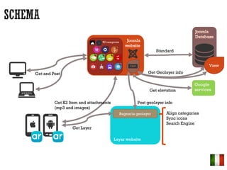
- 3. K2 categories Layar website Google services Bagnaria geolayer Get elevation Standard Get and Post Get K2 Item and attachments (mp3 and images) Get Layer Get Geolayer info View Post geolayer info Align categories Sync icons Search Engine
- 4. Joomla + K2 Component StyleWare K2 google maps plugin
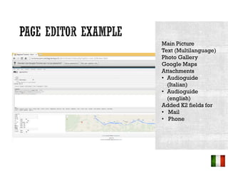
- 5. Main Picture Text (Multilanguage) Photo Gallery Google Maps Attachments ? Audioguide (Italian) ? Audioguide (english) Added K2 fields for ? Mail ? Phone
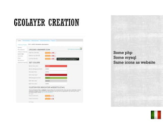
- 7. Some php Some mysql Same icons as website
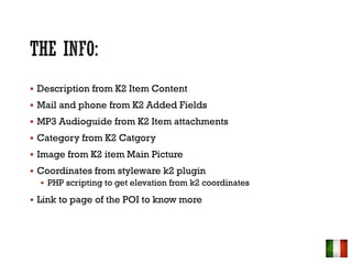
- 8. ? Description from K2 Item Content ? Mail and phone from K2 Added Fields ? MP3 Audioguide from K2 Item attachments ? Category from K2 Catgory ? Image from K2 item Main Picture ? Coordinates from styleware k2 plugin ? PHP scripting to get elevation from k2 coordinates ? Link to page of the POI to know more
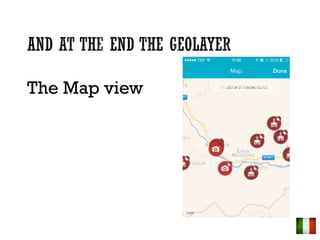
- 12. The Map view
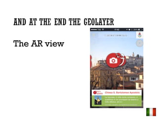
- 13. The AR view
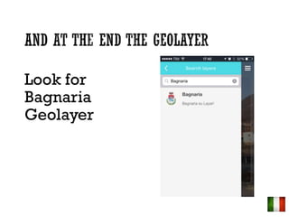
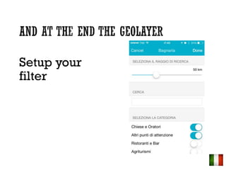
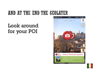
- 14. Look around for your POI
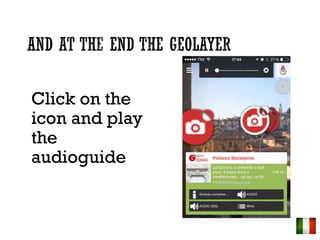
- 15. Click on the icon and play the audioguide
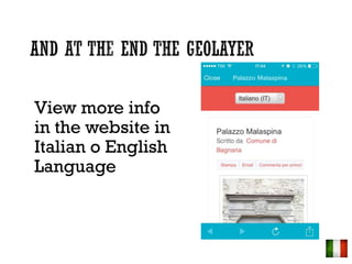
- 16. View more info in the website in Italian o English Language
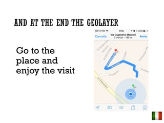
- 17. Go to the place and enjoy the visit
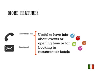
- 18. Direct Phone call Direct email Useful to have info about events or opening time or for booking in restaurant or hotels