Madt Ppt Contractors 031909 (Pdf)
•
2 likes•1,386 views
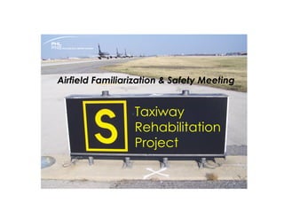
Mini-version of the airfield Movement Area Driver Training targeted at contractors prior to a taxiway rehabilitation job
1 of 21


Recommended
Biz Av Avionics Systems Insight Oct 2010
Biz Av Avionics Systems Insight Oct 2010Jeremy R.C. Cox
Ěý
This document provides a historical overview of avionics systems in business jet aircraft cockpits, ending with a review of Dassault Falcon cockpits from 1965 to present. It begins by defining avionics as aviation electronics and describes the role of early avionics such as basic instruments. The document then reviews the evolution of key avionics components like airspeed indicators and flight management systems. Finally, it highlights the avionics suites installed on different Falcon models from the Falcon 20 to the Falcon 7X.Mlat ads-b-reference-guide
Mlat ads-b-reference-guideSergio Llugdar
Ěý
But what exactly is multilateration? How does it work?
Why are ANSPs and airports increasingly adopting it?
What are its benefits? What about certification?
How will it aid in the transition to ADS-B?
Most importantly, how can it benefit your organization?ADS-B: A Special Report
ADS-B: A Special ReportGina Longo - Britain Unleashed
Ěý
A plain-language special report on what ADS-B is, how it works, why you should equip before the deadline, and why just being legal may not mean you're as safe as you could be.
A TL to build team presentation
A TL to build team presentationDoug Scannell
Ěý
This document discusses passenger sensitive equipment at Terminal 5, including boarding bridges, ground power, guidance systems, vertical carousels, elevators, escalators, and automatic doors. It provides information on areas of responsibility, stakeholders, timelines, and examples of equipment layouts. The goal is to ensure integrated technical plans and solutions across the Terminal 5 campus.Compartive study of surface heliport and elevated heliport
Compartive study of surface heliport and elevated heliportJayakrishnan Jayarajan
Ěý
This is a brief comparitive study of "surface and elevated " heliports which i have done for my project during summer internship .Flying Rules, Aerodrome markings and navigation 
Flying Rules, Aerodrome markings and navigation Yuuji
Ěý
This document discusses different topics related to flying rules, aerodrome markings and navigation including: flying rules for IFR and VFR, aerodrome markings like runway and taxiway markings, aerodrome signs, and different types of radio navigation aids like VOR, NDB, ILS, DME, RNAV, and RNP. The objectives are for trainees to understand different flying rules, aerodrome signs and layouts, and how to identify different navigation aids.Axle load monitoring for freight trucks
Axle load monitoring for freight trucksLuba Nikonorenkova
Ěý
The document discusses an axle load monitoring system that uses sensors mounted on a truck's air suspension to detect the weight on each axle. The sensors send analog signals to a digital converter that puts the data on the CAN bus. This data is then sent to the driver's display and a tracking device that uploads it to an online server. The system allows drivers to monitor axle weight during loading and unloading, and fleet managers to track location, route, and axle weights in real time to prevent overloading and cargo theft.ADSB with GAGAN
ADSB with GAGANShivam Sharma
Ěý
The document discusses ADS-B technology and how it can improve air traffic surveillance when combined with GAGAN, India's satellite-based augmentation system. ADS-B uses GPS to broadcast flight information like location and speed to nearby aircraft and ground stations every second, providing more real-time awareness than radar which has a 12 second delay. When paired with GAGAN, ADS-B with GAGAN will give pilots and air traffic controllers more accurate location data to safely manage airspace. This could have prevented past mid-air collisions in India, like the 1966 crash that killed 349 people due to lack of information in dense traffic. The document argues for implementing ADS-B with GAGAN to improve aviation safety as air traveloia_cip
oia_cipMark Nardo
Ěý
The Capital Improvement Program for fiscal years 2013-2018 at Orlando International Airport outlines a $1.1 billion plan to maintain and expand airport facilities. The major projects include expanding terminal areas like ticket lobbies and baggage systems, replacing automated people movers, improving airside facilities, and developing an intermodal transit system and parking facilities to support growth at the airport's South Terminal. The plan's objectives are to maintain existing facilities, modify facilities to achieve increased terminal capacity, improve international processing, and develop non-aviation revenue opportunities. Funding will come from a variety of sources including grants, airport funds, passenger facility charges, and bonds.Lorry crane operator_handbook_1st_revision_2019
Lorry crane operator_handbook_1st_revision_2019Cuong Manh Nguyen
Ěý
This document contains information for operating a lorry crane safely, including:
- A load chart showing the safe working load at different boom lengths up to 20 meters.
- Instructions to fully extend outriggers on firm, level ground and avoid overhead obstructions when lifting.
- A checklist for the crane supervisor including conducting a risk assessment, checking certificates and maintenance logs, and ensuring safe work procedures are followed.
- A pre-operation checklist for inspecting the crane structure and components, engine, hydraulic and braking systems, limit switches, and fire extinguisher.EGNOS benefits for aviation
EGNOS benefits for aviationThe European GNSS Agency (GSA)
Ěý
Presented by Gian Gherardo Calini (Head of Market Development) in Toulouse - France at EGNOS flight event, 6-7 May 2015 IFR Flight Planning
IFR Flight PlanningYuuji
Ěý
This document discusses factors that must be considered when planning an IFR flight, including origin and destination, weather, route, distance, speed, weight and balance, fuel, and alternates. It also describes the components of a flight plan such as the fuel plan, weight restrictions, navigation plan, air traffic services routing, and weather forecast. Finally, it provides details on various stages of flight like standard instrument departures, transitions, enroute navigation, standard terminal arrivals, instrument approach procedures, and ETOPS flights.Helitech - Leonardo Helicopters Division: Technology for Safety
Helitech - Leonardo Helicopters Division: Technology for SafetyLeonardo
Ěý
During Helitech 2016 Leonardo Helicopters Division held a presentation called "Technology for Safety" focused on:
- Ergonomics & Human Machine Interface;
- Dry Run Transmission Capabilities;
- Design to Performance;
- OGP standards compliance across different roles.Signals
Signalsgeorgezac
Ěý
This document discusses signaling systems and the classification of signals. It covers the objectives of signaling which are to provide efficient train movement, ensure safety between trains, maximize track utility, and guide train movement during repairs. Signals are classified based on their operating characteristics such as fixed, hand, and detonating signals. They can also be classified functionally as stop, warner, and shunting signals. Locationally, signals include reception signals like outer and home signals as well as departure signals like starter and advance starter signals. Special signals include routing and calling-on signals. The document provides diagrams to illustrate the different types of signals and their indications.SESAR at World ATM Congress 2016 - Exploratory Research programme
SESAR at World ATM Congress 2016 - Exploratory Research programmeSESAR Joint Undertaking
Ěý
The document discusses SESAR exploratory research. It provides an introduction from Dr. Stella Tkatchova of SESAR JU and outlines two WPE project examples on airport slot allocation (ACCESS) and modeling ATM policy changes (CASSIOPEIA). It also discusses how SESAR takes science seriously through its Scientific Committee, chaired by Peter Hecker. The way forward and closing remarks are provided by Dr. Tkatchova.European Rotors - AW609 for HEMS Market
European Rotors - AW609 for HEMS MarketLeonardo
Ěý
Leonardo attended European Rotors HEMS Conference focusing on the AW609 tiltrotor advantages for EMS and on helicopter operations in Icing ConditionsAviation powered by EGNOS: high precision, low investment
Aviation powered by EGNOS: high precision, low investmentThe European GNSS Agency (GSA)
Ěý
Katerina Strelcova, European GNSS Agency
Presented on 15th April 2015, at the session "EGNOS - the European Satnav Solution for Pilots" (2015 AERO Friedrichshafen, Germany).Tokyo Flight Service Center
Tokyo Flight Service CenterSecretaria de Aviação Civil da Presidência da República
Ěý
The document summarizes the remote air-ground communication services provided by the Tokyo Flight Service Center (FSC) for small airports in Japan. The Tokyo FSC uses a REMOTE-AFIS system to provide air traffic services like clearance delivery and aerodrome advisories for airports without control towers. A single flight information officer remotely handles air traffic communication for multiple small airports using cameras, radios, and data links with airport operators and air traffic control. The system ensures safety through agreements with local weather services and area control centers for coordination.KAIA_Site Plan-Model
KAIA_Site Plan-ModelAhmed Salah El-din
Ěý
Zone A - Terminal Processor handles departing passengers. Zones B through H cover different areas of the airport including domestic and international piers, parking areas, and support buildings. The document provides labels and numbers for over 30 facilities that support operations at the airport such as air traffic control towers, data centers, maintenance stations, and utility areas.Sesar General presentation
Sesar General presentationSESAR Joint Undertaking
Ěý
This presentation provides an overview of the role of air traffic management in Europe, the challenges of future growth, and the Single European Sky initiative. It discusses how the SESAR program is developing new air traffic management technologies and procedures through a public-private partnership to enable more efficient airspace usage and meet rising demand while improving safety and environmental performance. The presentation outlines SESAR's goals and organization, as well as its progress in developing and validating new concepts of operations through research projects across Europe.European Rotors - Mission Management System’s Capabilities for Law Enforcemen...
European Rotors - Mission Management System’s Capabilities for Law Enforcemen...Leonardo
Ěý
Leonardo attended at European Rotors the Police Aviation Conference illustrating its Mission Management System’s capabilities for Law Enforcement OperatorsRunway Incursion, Airport Signage and Markings - Presentation for future CFIs
Runway Incursion, Airport Signage and Markings - Presentation for future CFIsThomas Bergen
Ěý
şÝşÝߣ about Runway Incursion, Airport Signage and Markings that me and David Hogg made for our CFI exam in early 2015.BasicAirportOperation - TerminalFacilities
BasicAirportOperation - TerminalFacilitiesAiDY
Ěý
The document describes the facilities and operations of an airport terminal. It outlines the organizational structure and responsibilities of various divisions including terminal facilities, engineering, operations, security systems, baggage handling systems, and track transit systems. It provides details on the maintenance and operations of the terminal buildings, mechanical systems, electrical systems, and other infrastructure.Taxiway design perfect ppt
Taxiway design perfect pptVijay Reddy
Ěý
The document provides information about the components and design of airport taxiways. It discusses the functions of taxiways as connecting runways, aprons, hangars and terminals. Key factors considered in taxiway layout include avoiding interference with aircraft using runways and providing the shortest route from runways. The document also outlines geometric design standards for taxiways such as recommended widths, gradients and sight distances set by ICAO for different aircraft types. Turning radii are designed so aircraft can negotiate curves without reducing speed significantly.C104 atc communication
C104 atc communicationfavata
Ěý
This document provides an overview of basic air traffic control communication procedures. It reviews the roles and responsibilities of each ATC position including clearance delivery, ground control, tower control, departure control, center control, approach control, and provides examples of pilot-controller communications. It emphasizes that while procedures vary between facilities, the basic information exchanged is consistent, including aircraft callsign, route clearance, altitude assignments, frequencies changes. The document concludes with a review example of a flight from Miami to Nashville.Runway orientation
Runway orientationrehan5c
Ěý
Runways are paved surfaces on airports designed for aircraft landing and takeoff. Runways have markings and lighting to guide pilots. Key markings include runway numbers, centerline, edge lines, and threshold markings. Runway lighting includes edge lights, centerline lights, and approach lighting systems. Factors like surface type, length, width, and wind direction determine which runway is active. Strict procedures are in place in and around runways to prevent incursions and ensure safety.SUN N FUN 2014 NOTAM - 3-21-2014
SUN N FUN 2014 NOTAM - 3-21-2014FAA Safety Team Central Florida
Ěý
This is the latest NOTAM for SUN 'N FUN 2014. For the most current information go to http://www.sun-n-fun.org/flyin.aspxVisual approach
Visual approachAbuRoma
Ěý
This document provides definitions and procedures for visual approaches, contact approaches, and circling to land from an instrument approach. It defines a visual approach as approaching visually and clearing clouds to land at an airport. A contact approach allows proceeding visually to the destination airport when clear of clouds with at least 1 mile visibility. Circling to land brings an aircraft into position to land on a runway not aligned with the instrument approach. It provides circling area dimensions and procedures to maintain visual contact with the runway environment while circling to land.Air Traffic Control and Nav Aids
Air Traffic Control and Nav AidsEmmanuel Fuchs
Ěý
The document discusses various technologies used in air traffic control and air navigation, including navigation aids like VOR, ILS, DME, RNAV, and satellite navigation. It also covers flight planning, airport charts, approach charts, and the role of the flight management system.airportlightssignsandmarkings-110118113918-phpapp01.ppt
airportlightssignsandmarkings-110118113918-phpapp01.pptJohnDejak2
Ěý
Discuss lighting and marking of obstacles at airports and signage for airport safety.
More Related Content
What's hot (13)
oia_cip
oia_cipMark Nardo
Ěý
The Capital Improvement Program for fiscal years 2013-2018 at Orlando International Airport outlines a $1.1 billion plan to maintain and expand airport facilities. The major projects include expanding terminal areas like ticket lobbies and baggage systems, replacing automated people movers, improving airside facilities, and developing an intermodal transit system and parking facilities to support growth at the airport's South Terminal. The plan's objectives are to maintain existing facilities, modify facilities to achieve increased terminal capacity, improve international processing, and develop non-aviation revenue opportunities. Funding will come from a variety of sources including grants, airport funds, passenger facility charges, and bonds.Lorry crane operator_handbook_1st_revision_2019
Lorry crane operator_handbook_1st_revision_2019Cuong Manh Nguyen
Ěý
This document contains information for operating a lorry crane safely, including:
- A load chart showing the safe working load at different boom lengths up to 20 meters.
- Instructions to fully extend outriggers on firm, level ground and avoid overhead obstructions when lifting.
- A checklist for the crane supervisor including conducting a risk assessment, checking certificates and maintenance logs, and ensuring safe work procedures are followed.
- A pre-operation checklist for inspecting the crane structure and components, engine, hydraulic and braking systems, limit switches, and fire extinguisher.EGNOS benefits for aviation
EGNOS benefits for aviationThe European GNSS Agency (GSA)
Ěý
Presented by Gian Gherardo Calini (Head of Market Development) in Toulouse - France at EGNOS flight event, 6-7 May 2015 IFR Flight Planning
IFR Flight PlanningYuuji
Ěý
This document discusses factors that must be considered when planning an IFR flight, including origin and destination, weather, route, distance, speed, weight and balance, fuel, and alternates. It also describes the components of a flight plan such as the fuel plan, weight restrictions, navigation plan, air traffic services routing, and weather forecast. Finally, it provides details on various stages of flight like standard instrument departures, transitions, enroute navigation, standard terminal arrivals, instrument approach procedures, and ETOPS flights.Helitech - Leonardo Helicopters Division: Technology for Safety
Helitech - Leonardo Helicopters Division: Technology for SafetyLeonardo
Ěý
During Helitech 2016 Leonardo Helicopters Division held a presentation called "Technology for Safety" focused on:
- Ergonomics & Human Machine Interface;
- Dry Run Transmission Capabilities;
- Design to Performance;
- OGP standards compliance across different roles.Signals
Signalsgeorgezac
Ěý
This document discusses signaling systems and the classification of signals. It covers the objectives of signaling which are to provide efficient train movement, ensure safety between trains, maximize track utility, and guide train movement during repairs. Signals are classified based on their operating characteristics such as fixed, hand, and detonating signals. They can also be classified functionally as stop, warner, and shunting signals. Locationally, signals include reception signals like outer and home signals as well as departure signals like starter and advance starter signals. Special signals include routing and calling-on signals. The document provides diagrams to illustrate the different types of signals and their indications.SESAR at World ATM Congress 2016 - Exploratory Research programme
SESAR at World ATM Congress 2016 - Exploratory Research programmeSESAR Joint Undertaking
Ěý
The document discusses SESAR exploratory research. It provides an introduction from Dr. Stella Tkatchova of SESAR JU and outlines two WPE project examples on airport slot allocation (ACCESS) and modeling ATM policy changes (CASSIOPEIA). It also discusses how SESAR takes science seriously through its Scientific Committee, chaired by Peter Hecker. The way forward and closing remarks are provided by Dr. Tkatchova.European Rotors - AW609 for HEMS Market
European Rotors - AW609 for HEMS MarketLeonardo
Ěý
Leonardo attended European Rotors HEMS Conference focusing on the AW609 tiltrotor advantages for EMS and on helicopter operations in Icing ConditionsAviation powered by EGNOS: high precision, low investment
Aviation powered by EGNOS: high precision, low investmentThe European GNSS Agency (GSA)
Ěý
Katerina Strelcova, European GNSS Agency
Presented on 15th April 2015, at the session "EGNOS - the European Satnav Solution for Pilots" (2015 AERO Friedrichshafen, Germany).Tokyo Flight Service Center
Tokyo Flight Service CenterSecretaria de Aviação Civil da Presidência da República
Ěý
The document summarizes the remote air-ground communication services provided by the Tokyo Flight Service Center (FSC) for small airports in Japan. The Tokyo FSC uses a REMOTE-AFIS system to provide air traffic services like clearance delivery and aerodrome advisories for airports without control towers. A single flight information officer remotely handles air traffic communication for multiple small airports using cameras, radios, and data links with airport operators and air traffic control. The system ensures safety through agreements with local weather services and area control centers for coordination.KAIA_Site Plan-Model
KAIA_Site Plan-ModelAhmed Salah El-din
Ěý
Zone A - Terminal Processor handles departing passengers. Zones B through H cover different areas of the airport including domestic and international piers, parking areas, and support buildings. The document provides labels and numbers for over 30 facilities that support operations at the airport such as air traffic control towers, data centers, maintenance stations, and utility areas.Sesar General presentation
Sesar General presentationSESAR Joint Undertaking
Ěý
This presentation provides an overview of the role of air traffic management in Europe, the challenges of future growth, and the Single European Sky initiative. It discusses how the SESAR program is developing new air traffic management technologies and procedures through a public-private partnership to enable more efficient airspace usage and meet rising demand while improving safety and environmental performance. The presentation outlines SESAR's goals and organization, as well as its progress in developing and validating new concepts of operations through research projects across Europe.European Rotors - Mission Management System’s Capabilities for Law Enforcemen...
European Rotors - Mission Management System’s Capabilities for Law Enforcemen...Leonardo
Ěý
Leonardo attended at European Rotors the Police Aviation Conference illustrating its Mission Management System’s capabilities for Law Enforcement OperatorsSimilar to Madt Ppt Contractors 031909 (Pdf) (20)
Runway Incursion, Airport Signage and Markings - Presentation for future CFIs
Runway Incursion, Airport Signage and Markings - Presentation for future CFIsThomas Bergen
Ěý
şÝşÝߣ about Runway Incursion, Airport Signage and Markings that me and David Hogg made for our CFI exam in early 2015.BasicAirportOperation - TerminalFacilities
BasicAirportOperation - TerminalFacilitiesAiDY
Ěý
The document describes the facilities and operations of an airport terminal. It outlines the organizational structure and responsibilities of various divisions including terminal facilities, engineering, operations, security systems, baggage handling systems, and track transit systems. It provides details on the maintenance and operations of the terminal buildings, mechanical systems, electrical systems, and other infrastructure.Taxiway design perfect ppt
Taxiway design perfect pptVijay Reddy
Ěý
The document provides information about the components and design of airport taxiways. It discusses the functions of taxiways as connecting runways, aprons, hangars and terminals. Key factors considered in taxiway layout include avoiding interference with aircraft using runways and providing the shortest route from runways. The document also outlines geometric design standards for taxiways such as recommended widths, gradients and sight distances set by ICAO for different aircraft types. Turning radii are designed so aircraft can negotiate curves without reducing speed significantly.C104 atc communication
C104 atc communicationfavata
Ěý
This document provides an overview of basic air traffic control communication procedures. It reviews the roles and responsibilities of each ATC position including clearance delivery, ground control, tower control, departure control, center control, approach control, and provides examples of pilot-controller communications. It emphasizes that while procedures vary between facilities, the basic information exchanged is consistent, including aircraft callsign, route clearance, altitude assignments, frequencies changes. The document concludes with a review example of a flight from Miami to Nashville.Runway orientation
Runway orientationrehan5c
Ěý
Runways are paved surfaces on airports designed for aircraft landing and takeoff. Runways have markings and lighting to guide pilots. Key markings include runway numbers, centerline, edge lines, and threshold markings. Runway lighting includes edge lights, centerline lights, and approach lighting systems. Factors like surface type, length, width, and wind direction determine which runway is active. Strict procedures are in place in and around runways to prevent incursions and ensure safety.SUN N FUN 2014 NOTAM - 3-21-2014
SUN N FUN 2014 NOTAM - 3-21-2014FAA Safety Team Central Florida
Ěý
This is the latest NOTAM for SUN 'N FUN 2014. For the most current information go to http://www.sun-n-fun.org/flyin.aspxVisual approach
Visual approachAbuRoma
Ěý
This document provides definitions and procedures for visual approaches, contact approaches, and circling to land from an instrument approach. It defines a visual approach as approaching visually and clearing clouds to land at an airport. A contact approach allows proceeding visually to the destination airport when clear of clouds with at least 1 mile visibility. Circling to land brings an aircraft into position to land on a runway not aligned with the instrument approach. It provides circling area dimensions and procedures to maintain visual contact with the runway environment while circling to land.Air Traffic Control and Nav Aids
Air Traffic Control and Nav AidsEmmanuel Fuchs
Ěý
The document discusses various technologies used in air traffic control and air navigation, including navigation aids like VOR, ILS, DME, RNAV, and satellite navigation. It also covers flight planning, airport charts, approach charts, and the role of the flight management system.airportlightssignsandmarkings-110118113918-phpapp01.ppt
airportlightssignsandmarkings-110118113918-phpapp01.pptJohnDejak2
Ěý
Discuss lighting and marking of obstacles at airports and signage for airport safety.
Sema History and Overview
Sema History and OverviewClark Jay Wilson
Ěý
History of United States Army Aviation Special Electronic Mission Aircraft (SEMA) from the Vietnam conflict to date.Precission Approach Path Indicator (PAPI)
Precission Approach Path Indicator (PAPI)Suhanto Tuban
Ěý
The Precision Approach Path Indicator (PAPI) provides visual guidance for pilots during approaches and landings. It uses a combination of red and white lights to indicate the aircraft's positioning relative to the ideal glidepath. The PAPI was developed to be more accurate than its predecessor, the VASI system. It generates lighting from a single wing bar rather than two longitudinal bars. In 1995, the PAPI was accepted internationally by ICAO as the standard visual approach indicator.Sectionals (Groups B/D)
Sectionals (Groups B/D)Logan Nielsen
Ěý
This presentation explains how to read a sectional as well as how to depict all symbols that can be found on a sectional.mh_saad_resume (2) - Copy
mh_saad_resume (2) - Copymohamed saad
Ěý
This document contains contact information and a resume for Mohamed Saad Abd El Sabour Ahmed Helaly. It lists his address, phone numbers, email, personal details such as nationality and date of birth, education history including graduating from Alexandria University's Faculty of Law in 2002, technical skills including Microsoft Office and various operating systems, and professional experience conducting subsea inspections for oil and gas companies from 2013 to 2015.Rwy Sfty Flash Cards AOPA.pdf
Rwy Sfty Flash Cards AOPA.pdfSantiago Hidalgo
Ěý
This document provides information on various signs and markings used at airports to aid pilots in taxiing, taking off, and landing safely. It includes descriptions and diagrams of signs like runway holding position signs, taxiway direction signs, and destination signs. It also covers pavement markings such as runway holding position markings, taxiway centerline markings, and non-movement area boundaries. Lighting systems are described, including runway edge lights, taxiway edge lights, and runway end identifier lights. The document is intended to help pilots understand airport signage and markings.Communicating With Atc Iii
Communicating With Atc IiiRiverol
Ěý
The document provides an overview of communicating with air traffic control (ATC) including basic radio communications procedures, contacting clearance delivery, ground control, and the tower for departures and arrivals. It discusses Automatic Terminal Information Service (ATIS), phonetic alphabet, aircraft identification, radio techniques and procedures, and ATC responses and pilot read-backs.AIRPORT SIGNS, RUNWAY AND TAXIWAY MARKINGS.pptx
AIRPORT SIGNS, RUNWAY AND TAXIWAY MARKINGS.pptxarafahmedsadib97
Ěý
This document summarizes ICAO recommended airport signs, runway, and taxiway markings. It describes various mandatory instruction signs, information signs, runway markings including thresholds, centerlines, and aiming points. It also outlines taxiway markings such as holding positions, stop bars, and closed or non-load bearing surface markings.Airfield Lighting Introductory
Airfield Lighting IntroductoryMilten Jose
Ěý
This is a introductory presentation for airfield lighting that created by Milten Jose Airfield Engineer, AMAINDIA PVT. LTD. for Mumbai international airport limited.ACRP 4-09
Risk Assessment Method to Support Modification of Airfield Separat...
ACRP 4-09
Risk Assessment Method to Support Modification of Airfield Separat...Mukeshwaran Balu
Ěý
AIRPORT DESIGNThe Successful Cross Country Part 1 (2010)
The Successful Cross Country Part 1 (2010)FAA Safety Team Central Florida
Ěý
This document provides guidance for pilots conducting cross-country flights, including:
- Planning tips such as obtaining a weather briefing, reviewing charts and publications, and understanding airport operations.
- Key rules and markings including runway safety areas, hold short lines, and signs.
- Scenarios walking through planning a flight from New Century Air Center to Ottumwa Industrial Airport and Eppley Airfield, focusing on interpreting airport diagrams and publications.Sample
Samplemoshthepitt
Ěý
The document provides instructions for instrument navigation along Route 1, including procedures for takeoff, en route checks, holding patterns, approaches, and landing. It describes setting up radios and navigation aids at checkpoints A and B, then holding at the GG/GV beacon before intercepting the localizer for an ILS approach to runway 07 at NV. Precise instructions are given for radio frequencies, headings, altitudes, and checks to perform at each stage of flight.