


More Related Content
Viewers also liked (20)
Similar to Ýñý¿¯ªý¿Ê௢°ÏýîÊ࿵¯¢°Ï°Ï4°Ø (20)


More from ¢çùƒ ò₤V (6)


Ýñý¿¯ªý¿Ê௢°ÏýîÊ࿵¯¢°Ï°Ï4°Ø
- 1. 2016/10/30 FOSS4G NARA.KANSAI Ýñý¿¯ªý¿Ê௢°ÏýîÊ࿵¯¢°Ï°Ï4°Ø - Code for Nara£ŸÆ§B§Õ - Code for Nara ǺÝÚ Yasushi ISHIZUKA
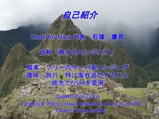
- 2. æ奤§B§Õ Code for Nara ǺÝÚ ò₤V ¢çùƒ æå°óÀ¡ôûʿʊ˴˵ˡËùËÂÀ¿ ôIȤËíËõˋ`ÊöËçˋ`ËÅüç˴˵ˡËùË àÊöÑȤôûÅÅ äÄÊù¤ÈëãäÆë—Ê¿ÊŠÊ°Êà ôûüàÊúOSMÊ·ÜÆû Yasushi ISHIZUKA Facebook: https://www.facebook.com/yasushi00 Twitter: @yasushi00j
- 3. Code for Nara ÊàÊü ¢ˆÇÔËÊËì˵Ëà üøåÖÊöø¼Êò£ŸÑ₤ Code for Nara Êö§þ¤µ ÊßÊàÊà ¯kÝÚáÖàï
- 4. Code for Nara ÊàÊü
- 5. Code for Nara ÊàÊü ´C ÊàÊãÊù¢¥Ê´ÀÂÊàÊãÊùÊáÊ₤ÊŠ - ÊàÊÊÊ΢¥Ê´Ê·Ëìˋ`Ë¿Êù À¡áöê¥Ê·øˆÊõÀÂáöê¥Ê·Æ»ÊÁÀ¿ ÊàÊÊÊÎâÚáŸÊöÊãÊà À¡IT(code)ÊöêÎÊàáöê¥Êööá£₤ÊöàÖ¤üÀ¿ Ê·á¢ø¡ÊñÊóÊÊÊŠàöØããäÍ
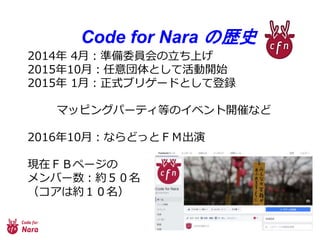
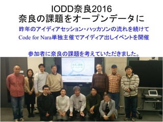
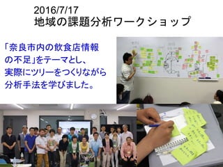
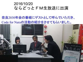
- 6. Code for Nara Êösòñ 2014áõ 4åôȤòðö₤T£ÃÊöêÂÊêèüÊý 2015áõ10åôȤàöØããäÍÊàÊñÊó£ŸÆÕ_ò¥ 2015áõ 1åôȤí»ò§ËøËõËýˋ`ËèÊàÊñÊóçúÍh ËßËûËå˵˯Ëîˋ`ËóËÈçàÊöËÊËì˵ËàÕ_ÇÔÊòÊè 2016áõ10åôȤÊòÊÕÊèÊûÊàÈóÈë°—îï ˜FåÖÈóÈôËÖˋ`Ë¡Êö ËÃ˵ËÅˋ`ò»È¤¥sÈçȯû« È´Ë°ËÂÊü¥sÈÝȯû«Èˋ
- 7. ¢ˆÇÔËÊËì˵Ëà
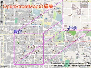
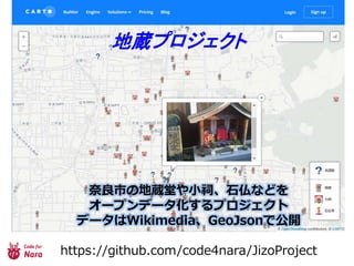
- 8. áöê¥Ëˆˋ`Ëæ˵Ëúˋ`ˢ˧˵ WikiPediaË¢ËÎ˵ + OpenStreetMapËßËûËå˵˯Ëîˋ`ËóËÈ ÈýȯÈÝÈÇáõÈÝÈÝåôÈýÈ°àí šÑ áöê¥éÛæÆǵáö꥟ÛË£ËÔËòˋ`ËüËÎË¿
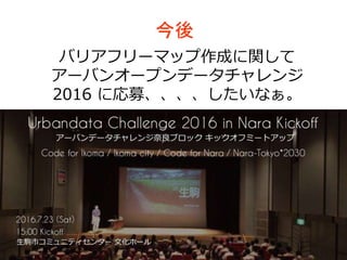
- 17. üøåÖÊöø¼Êò£ŸÑ₤
- 19. Ëêˋ`ËÁ§¶¥Ýòôä˜
- 22. Code for Nara Êö§þ¤µ
- 23. §þÃà ËÅËõËÂËíËõˋ`ËßËûËææ¼°èÊùÕvÊñÊó ËÂˋ`ËÅ˵ˈˋ`Ëæ˵Ëúˋ`Ë¢ËêËÐ˚˵ˡ 2016 Êùõá¥ÀÂÀÂÀÂÀÂÊñÊ¢ÊÊÊòÊÀÀÈ
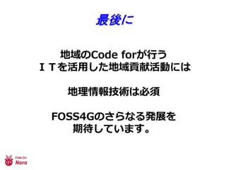
- 25. ÊãÊØÊàÊá Code for Nara ÊúÊü¯åôçÖÈÝùÛõæÊöØ¿Êù À¡Ñ´â»£ÃÀ¿Ê·ÅÅÊûÊóÊÊÊßÊ¿ÀÈ ýö¥ÆìY¡þÊüÊÂÊõÊßʣʵÊöÊúÀÂáöê¥Êù édöÑʘÊÂÊŠñ§Êöýö¥ÆʷʈǻÊêÊñÊóÊÊÊßÊ¿ÀÈ §þÃÃÊö£ŸÆñ§ÃÊðÀÂËÊËì˵ËàÔ\ÆÊòÊèÊ·À ÊÑÊûÊ₤ÊÅÊÕʵÊùåÊñ¤üÊûÊóÊÊÊßÊ¿ÀÈ
- 26. ÊßÊàÊÃ