Mapping Data - A guide for making geodata visualizations
- 1. MAPPING DATA A guide for making geodata visualizations
- 2. CIVIC HACKERS MAPPABLE.INFO WE AREN‘T JOURNALISTS, BUT... BLOGGER MAPPABLE.INFO URBAN PLANERS @PatrickStotz @A_Tack
- 3. WHY WE MAKE MAPS and why journalists should do so more often MAPPABLE.INFO
- 4. MAPPABLE.INFO TO DISCOVER OTHERWISE HIDDEN PATTERNS Source: John Snow 1854, public domain, http://upload.wikimedia.org/wikipedia/commons/2/27/Snow-cholera-map-1.jpg
- 5. TO COMMUNICATE WELL KNOWN PATTERNS MORE CLEARLY MAPPABLE.INFO Source: Michel Jansen (@dawuss / twitter) https://twitter.com/dawuss/status/382163898566057984/photo/1 by Berliner Morgenpost 2013
- 6. TO GAIN INSIGHTS & IMPROVE DECISSION MAKING MAPPABLE.INFO Source: http://senseable.mit.edu/livesingapore/images/raining_taxis_lg.png - LIVE Singapore! MIT Senseable City Lab
- 7. INCREASE TRAFFIC ON YOUR SITE :-) MAPPABLE.INFO Source: http://readingbyeugene.files.wordpress.com/2013/12/screen-shot-2013-12-23-at-11-31-00-am.png
- 8. NECESSARY KNOW HOW FOR MAKING GEODATA VISUALIZATIONS 1 MAPPABLE.INFO Finding / generating data sets a) Searching data for a given story b) Searching a story inside a given data set Software skills and geospatial analytics a) Software skills (->Mappable Toolset) b) Skills in (exploratory) geodata analytics Presenting / visualizing / validating a) Dataviz types and techniques b) Validating results 2 3
- 9. ALMOST EVERYTHING IS “MAPPABLE” (geo-) data everywhere MAPPABLE.INFO 1
- 10. MAPPABLE.INFO “Geodata is digital information, that can be related to a specific spatial location” Wikipedia BUT: where to find the necessary data sets for your project?
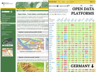
- 11. OPEN DATA PLATFORMS GERMANY . MAPPABLE.INFO
- 13. SELF GENERATED e.g. GPS TRACKING MAPPABLE.INFO MAPPABLE.INFO
- 14. SELF DRAWN e.g. QGIS MAPPABLE.INFO
- 15. WE ? UNUSUAL DATA SOURCES Examples from MAPPABLE.INFO MAPPABLE.INFO
- 16. OPEN DATA: NON-VOTERS MAPPABLE.INFO
- 17. MAPPABLE.INFO GEOCODING: PHONE DIRECTORIES
- 18. MAPPABLE.INFO SCRAPING: TAXI DATA
- 19. SCRAPING: TAXI DATA MAPPABLE.INFO Average speed
- 20. MAPPABLE.INFO SCRAPING: CARSHARING DATA
- 21. MAPPABLE.INFO
- 22. SELF DRAWN DATA: LIMITED ACCESSIBILITY MAPPABLE.INFO
- 23. IS THIS ALL COMPLICATED GIS STUFF? A look into our toolbox MAPPABLE.INFO Warning: nerdy stuff 2
- 24. MAPPABLE.INFO LIVE DEMO - FROM DATASET TO MAP 1. Gathering address data of refugee homes in Hamburg 2. Geocoding addresses using http://www.gpsvisualizer.com/geocoder/ 3. Importing and styling the data using QGIS 4. Adding district borders and median income 5. Exporting the map to the web using qgis2leaf
- 25. MAPPABLE.INFO CHOOSING THE RIGHT TOOLS - OUR TOOLBOX http://tiny.cc/mappable_tools_en
- 26. MAPFAILS Validating Geodata MAPPABLE.INFO 3
- 27. MAPPABLE.INFO SPEECHLESS mapfail.tumblr.com/ Source: mapfail.tumblr.com/
- 28. UNDERSTANDING GEODATA MAPPABLE.INFO Source: http://www.economist.com/node/1788311
- 29. UNDERSTANDING GEODATA Source: http://www.economist.com/node/1788311 MMAAPPPPAABBLLEE..IINNFFOO
- 30. MAPPABLE.INFO VALIDATING GEODATA Source: http://aureliamoser.com/2014/05/15/538-errors-plotting-crises-and-the-protocol-of-reprocessing-data/
- 31. VALIDATING GEODATA Source: http://aureliamoser.com/2014/05/15/538-errors-plotting-crises-and-the-protocol-of-reprocessing-data/ MAPPABLE.INFO
- 32. MAPPABLE CHEAT-SHEET A simple checklist for creating geovisualizations in data journalism http://tiny.cc/mappable_checklist_en MAPPABLE.INFO ? data handling ? cartographic representation ? visual implementation ? legend and attribution ? interactivity
- 33. MAPPING DATA questions? @PatrickStotz @A_Tack


