Old park wood leaflet v2
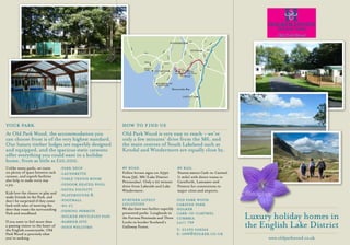
- 2. A591 A6 WINDERMERE 85 A6 A59 KENDAL A684 37 5 93 A595 A592 A5 A5 A6 A5084 07 85 4 M6 Millom 90 A5092 A5 36 A595 A65 Duddon OLD PARK HOLKER Sands WOOD HALL Cartmel ULVERTON A6 Grange- A59 0 Cark B5278 over-Sands Flookburgh 870 35 A5 BARROW-IN- FURNESS M6 Morecambe Bay LANCASTER 34