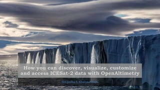
OpenAltimetry demo at Polar Data Forum #3
Download as pptx, pdf0 likes32 views

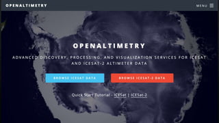
This document provides instructions for using an interface to explore satellite data. It allows the user to select dates, regions, and beams to display track and sampling information. The interface includes options to zoom, change projections, and display annotations, base layers, legends and feedback forms. It also provides tools to explore elevation profiles, segment data, and photon information by clicking on different elements.
1 of 12
Download to read offline
Ad
Recommended
Australia's Environment Explorer: Quick Tour
Australia's Environment Explorer: Quick Touraijmvandijk
Ěý
This document provides a tour of Australia's Environment Explorer, which allows users to view maps and charts about environmental data in Australia. It summarizes the key features including selecting map themes and types, using zoom and location tools, viewing regional or point data in charts, and accessing Street View imagery to see on-the-ground conditions. The tour demonstrates how to choose data years, regions, and map or data views to explore environmental information.FloodMap Mobile
FloodMap MobileJoshuaPrice
Ěý
The document outlines functionalities of an iPad application for flood hazard reports, including features to search current locations, customize maps with FEMA flood layers, and access additional resources. Users can retrieve and modify elevation data, structure values, and insurance information, as well as generate and email reports. The application integrates with USGS/NOAA stream gauges and provides a comprehensive portal for FEMA-related information.Gis Mapping Examples
Gis Mapping ExamplesALBAKRI MOHAMMAD
Ěý
The document discusses different types of maps and charts that can be used to visualize data based on the message, data, audience, and context. It lists common map types like choropleth, graduated symbol, dot density, and 3D maps. It also lists different chart types useful for different purposes, such as bar charts for comparing values, area charts for showing total values, line charts for trends over time, and scatter plots for revealing patterns. The document provides guidance on selecting the most appropriate visual based on the characteristics of the data and the goals of the analysis or communication.Examples of D3 Visualizations
Examples of D3 VisualizationsMD AMAN KHAN
Ěý
The document describes features of D3 visualizations, specifically focusing on bubble charts where bubble size and position depend on data dimensions. It highlights interactive elements such as a time selection drop-down, zooming, dragging, and tool-tips for additional data information. It also mentions the use of timeline charts to visualize data over different time periods.Ib geo skills overview
Ib geo skills overviewTom McLean
Ěý
The document provides an overview of various geographical skills and map types used for identifying and describing locations. It includes methods of location determination such as latitude and longitude, and different map types like thematic, topographic, and flow maps, as well as various graph types for data representation. Additionally, it discusses specific tools for visualizing data relationships, population structures, and development indicators.Iv visualisation on carbon emmisions final
Iv visualisation on carbon emmisions finalnirmalal
Ěý
The document describes the original layout and functionality of a data visualization tool, including drop down menus to filter data by year and type, slide bars to filter data ranges, options to adjust the scale and color intensity of filtered data, ability to change the displayed data without moving the slide bars, rollover options on countries for details and adding to a comparison table, clicking a box for a fisheye list and country selection, and a pop-up comparison table that can be sorted by column.GEOG101 Chapt02 lecture
GEOG101 Chapt02 lectureRichard Smith
Ěý
Maps are the primary tools of geography and cartography. They represent the earth's surface by using projections to translate the globe's spherical shape onto a flat surface, which inevitably distorts some characteristics. Different map projections prioritize preserving properties such as area, shape, distance, or direction. Thematic maps depict specific spatial distributions or categories of geographic data using symbols, colors, and other visual encoding techniques. Geographic information systems (GIS) are computer systems for assembling, analyzing, and visualizing geospatial data. GIS sees wide applications across fields like biology, political science, and urban planning.OLM Science6_2
OLM Science6_2gosomers
Ěý
This document provides an overview of key concepts for understanding maps and models of the Earth, including cardinal directions, latitude and longitude, map projections, and topographic maps. It defines common geographic terms like the prime meridian, equator, and magnetic declination. It also explains how maps represent the spherical Earth on a flat surface using different projections, and how topographic maps indicate elevation, contours, relief, and index contours.Topo and satellite views notes
Topo and satellite views notese045911
Ěý
Topographic maps and satellite views are used to interpret landforms and predict how erosion may change them over time. Cartographers create topographic maps using data from aerial photos and satellites, which photograph the Earth's surface. Topographic maps model the three-dimensional landscape using contour lines that connect points of equal elevation, with closer lines indicating steeper slopes. Contour lines never cross and show the shape and elevation of an area.GEOGRAPHIC SKILLS: FLOW-LINE MAPS
GEOGRAPHIC SKILLS: FLOW-LINE MAPSGeorge Dumitrache
Ěý
Flow-line maps are thematic maps used in cartography to illustrate the movement of objects across different areas, such as goods, species, and traffic volume, utilizing line symbols of varying widths to represent qualitative and quantitative data. There are three main types of flow maps: radial, network, and distributive, each serving different visualization purposes. To create a flow-line map, one must obtain a base map, determine line thickness according to data magnitude, and accurately plot movements with a clear legend.Dispatch Full Presentation
Dispatch Full Presentationguestf48423
Ěý
The document summarizes the key features and capabilities of the British Columbia Ministry of Forests and Range Dispatch Program. It provides an overview of the program's situational awareness tools like airtanker tracking, resource tracking, incident mapping, weather monitoring, and interagency cooperation functions for sharing resources across different agencies.reading maps
reading mapsShanson Shaji
Ěý
The document discusses different types of maps, including physical maps which show natural features and cultural maps which show man-made features, and how maps are classified based on their scale and function. It also covers how to read maps, including understanding scale using statement of scale, representative fraction, and linear scale, as well as using cardinal directions and signs/symbols.Interpreting maps
Interpreting mapsrrodri37
Ěý
Maps are diagrams that represent physical features and areas of land or sea. They have certain key elements like a title, legend, scale, and grid that help interpret the information shown. These elements include the title, which indicates the subject; the legend or key, which explains the symbols; and the scale, which shows the ratio of distances on the map to actual distances.GEOGRAPHIC SKILLS: DOT MAPS
GEOGRAPHIC SKILLS: DOT MAPSGeorge Dumitrache
Ěý
A dot map, or dot distribution map, uses dots to represent the presence and distribution of geographic phenomena, providing a visual scatter that indicates overall patterns such as population density. Historically significant in medical geography, Dr. John Snow utilized a dot map in 1854 to demonstrate the link between cholera outbreaks and contaminated water. To construct a dot map, one must select a base map, determine dot values, and accurately represent features across various administrative regions.Presantation on Map
Presantation on MapKhaza Ahmed Palash
Ěý
This document provides information about maps, including what they are, their types, advantages, and elements. Maps show the relationship between places on Earth's surface using distance, direction and size. There are physical/natural maps that show things like terrain and climate, and cultural maps that show things like land use, economics and politics. Maps have advantages like showing distributions and densities clearly using colors, but also disadvantages like being time-consuming to create and sometimes misleading. Key factors in map-making include scale, projection, skills, and the area and details needed. Elements on all maps include a compass rose, legend, bar scale, title and sometimes an inset map.Staff Luncheon Geosources
Staff Luncheon Geosourcesroycekitts
Ěý
The document discusses various geographic sources, both print and online, that are utilized in reference services for library users. It covers the importance of understanding geographic resources, including scale, projection, evaluation, and various types of atlases, gazetteers, and travel guides. Additionally, it highlights the emergence of online resources and geographic mashups that integrate maps with other digital content.Mapping concepts unit II
Mapping concepts unit IIH.M College of science and technology, Manjeri
Ěý
This document provides an overview of key concepts in mapping, including:
1) It describes the shape and size of the Earth and different ways of representing it, such as globes and maps.
2) It explains what maps are, different types of maps, and factors to consider like scale and purpose.
3) It discusses important concepts like map projections, elements of maps, and considerations for cartography like scale, accuracy, and resolution.Use of Maps and Charts in Research
Use of Maps and Charts in ResearchShashikant Kumar, Ph.D
Ěý
The document discusses the evolution and significance of using maps, graphs, and charts in research reports, particularly in social science research. It highlights the importance of visual representation in data analysis and presentation, emphasizing various types of charts and maps used for effectively communicating research findings. Additionally, it addresses the role of Geographic Information Systems (GIS) in enhancing the accuracy and accessibility of spatial data.Types of Maps
Types of Mapsitutor
Ěý
There are several types of maps that show different kinds of information. Political maps depict boundaries between countries and states. Physical maps show natural features like mountains, rivers, and oceans without man-made additions. Thematic maps represent single variables like climate, population, or elevation through different colors or symbols. Topographic maps use contour lines to illustrate the shape and elevation of landforms.GEOGRAPHIC SKILLS: CHOROPLETH MAPS
GEOGRAPHIC SKILLS: CHOROPLETH MAPSGeorge Dumitrache
Ěý
A choropleth map is a thematic map that displays statistical variables, such as population density, through shaded areas, with the term originating from Greek words for 'area' and 'multitude'. The first known choropleth map was created in 1826, and effective use requires normalization to accurately represent data independent of polygon size. Key principles for interpretation include recognizing geographic features, checking values against the legend, and using limited color categories for clarity.Digitalcartography
DigitalcartographyNimraArshad25
Ěý
Digital cartography involves the generation, storage, and editing of maps using computers. It has advantages over analog cartography like easier storage, updating, and access to data. Data is collected through remote sensing, aerial photography, scanning, and digitizing. GPS is also used. Digital databases store spatial and non-spatial data. Analysis and representation of data is facilitated using GIS tools. Digital cartography has made mapping accessible to non-specialists.Distribution maps
Distribution mapsivisdude82
Ěý
This document discusses different types of distribution maps, including dot maps, choropleth maps, proportional circle maps, and isoline maps. Dot maps represent values using dots, with dot density corresponding to measurement levels. Choropleth maps use color shades to show measurement variations across areas. Proportional circle maps represent data at points using circle areas scaled to values. Isoline maps show quantities that vary smoothly using lines or colors of equal value. Each map type has advantages like ease of use but also disadvantages like difficulty showing some relationships.pwp Vocabulary Unit 1
pwp Vocabulary Unit 1slopezandreu
Ěý
This document defines and describes various geographic terms and concepts. It defines key terms like geoid, globe, map, cardinal points, compass, physical map, thematic map, political map, key, meridian, parallel, latitude, longitude, and scale. Each term is defined in one or two concise sentences. The document provides essential information about basic geographic concepts.Interpreting maps
Interpreting mapsrrodri37
Ěý
Maps are diagrams that represent physical features and areas of land or sea. They have certain standard elements like a title, legend, scale, and grid that provide important information about what is shown and how to interpret it. These elements include the title, legend, scale, grid, and orientation that provide details on what the map shows, what symbols mean, distances and locations.Themating maping
Themating mapingVishvendu pandey
Ěý
A thematic map is a type of map that focuses on displaying information about a single theme or topic within a geographic area. Thematic maps emphasize specific distributions of phenomena, such as climate, population density, or other social, economic, or agricultural aspects. They show variations and relationships of geographic elements by using symbols instead of focusing on base map details. The purpose is to tell a story about places by mapping spatial patterns rather than just showing where locations are.Maps Ppt
Maps PptDonald Johnson
Ěý
Maps represent the three-dimensional Earth on a two-dimensional surface, inevitably introducing some distortion. Different map projections attempt to minimize this distortion in different ways, prioritizing accuracy of shapes, areas, or distances depending on the projection. No single projection can accurately depict the entire globe without compromising some property of geographic accuracy.GIS-KM-LRSP
GIS-KM-LRSPStig-Arne Kristoffersen
Ěý
This document discusses the role of geographic information systems (GIS) in knowledge management (KM), long-range strategic planning (LRSP), and exploration. It states that GIS is strongly supported as an essential tool for capturing, analyzing, and transferring geographically-referenced data and information to enable decision-making. Current and potential future uses of GIS in exploration include play mapping, analysis, and resource assessment to support KM, LRSP, and focusing exploration strategies. Overlaying various geologic factor maps in GIS applications allows identification of key play segments.Maps, projection and scale 2012
Maps, projection and scale 2012cindipatten
Ěý
The document discusses different types of maps and map scale. It explains that there are two main types of maps: reference maps, which show locations of features, and thematic maps, which emphasize a particular theme. It also defines scale as the ratio of distance on a map compared to actual distance. There are three types of scale: graphic, verbal, and representative fraction. The document provides examples of different scales and types of maps, including topographic, choropleth, dot, and cartogram maps.MODIS
MODISSabaragamuwa University of Sri Lanka
Ěý
MODIS is an instrument aboard the Terra and Aqua satellites that images the entire Earth every 1-2 days using 36 spectral bands. It provides data to study global land, ocean, and atmospheric processes. MODIS data products include measurements of sea surface temperature, snow cover, sea ice, vegetation indices, ocean color, and more. The data is available freely from NASA and USGS websites and can be used with GIS software for applications like monitoring wildfires, agriculture, water quality, and air pollution.MODIS (Moderate Resolution Imaging Spectrometer)
MODIS (Moderate Resolution Imaging Spectrometer)Nepal Flying Labs
Ěý
The document outlines the development and objectives of the Moderate Resolution Imaging Spectroradiometer (MODIS), an essential instrument for NASA's Earth Observing System, launched aboard the Terra and Aqua satellites for monitoring global environmental changes. It provides detailed information on the design, capabilities, and applications of MODIS, including how its data is processed and made available to users worldwide. Specifically, it highlights the significance of MODIS in analyzing terrestrial, atmospheric, and oceanic conditions, emphasizing its utility in fire detection and monitoring through real-time data applications.More Related Content
What's hot (20)
Topo and satellite views notes
Topo and satellite views notese045911
Ěý
Topographic maps and satellite views are used to interpret landforms and predict how erosion may change them over time. Cartographers create topographic maps using data from aerial photos and satellites, which photograph the Earth's surface. Topographic maps model the three-dimensional landscape using contour lines that connect points of equal elevation, with closer lines indicating steeper slopes. Contour lines never cross and show the shape and elevation of an area.GEOGRAPHIC SKILLS: FLOW-LINE MAPS
GEOGRAPHIC SKILLS: FLOW-LINE MAPSGeorge Dumitrache
Ěý
Flow-line maps are thematic maps used in cartography to illustrate the movement of objects across different areas, such as goods, species, and traffic volume, utilizing line symbols of varying widths to represent qualitative and quantitative data. There are three main types of flow maps: radial, network, and distributive, each serving different visualization purposes. To create a flow-line map, one must obtain a base map, determine line thickness according to data magnitude, and accurately plot movements with a clear legend.Dispatch Full Presentation
Dispatch Full Presentationguestf48423
Ěý
The document summarizes the key features and capabilities of the British Columbia Ministry of Forests and Range Dispatch Program. It provides an overview of the program's situational awareness tools like airtanker tracking, resource tracking, incident mapping, weather monitoring, and interagency cooperation functions for sharing resources across different agencies.reading maps
reading mapsShanson Shaji
Ěý
The document discusses different types of maps, including physical maps which show natural features and cultural maps which show man-made features, and how maps are classified based on their scale and function. It also covers how to read maps, including understanding scale using statement of scale, representative fraction, and linear scale, as well as using cardinal directions and signs/symbols.Interpreting maps
Interpreting mapsrrodri37
Ěý
Maps are diagrams that represent physical features and areas of land or sea. They have certain key elements like a title, legend, scale, and grid that help interpret the information shown. These elements include the title, which indicates the subject; the legend or key, which explains the symbols; and the scale, which shows the ratio of distances on the map to actual distances.GEOGRAPHIC SKILLS: DOT MAPS
GEOGRAPHIC SKILLS: DOT MAPSGeorge Dumitrache
Ěý
A dot map, or dot distribution map, uses dots to represent the presence and distribution of geographic phenomena, providing a visual scatter that indicates overall patterns such as population density. Historically significant in medical geography, Dr. John Snow utilized a dot map in 1854 to demonstrate the link between cholera outbreaks and contaminated water. To construct a dot map, one must select a base map, determine dot values, and accurately represent features across various administrative regions.Presantation on Map
Presantation on MapKhaza Ahmed Palash
Ěý
This document provides information about maps, including what they are, their types, advantages, and elements. Maps show the relationship between places on Earth's surface using distance, direction and size. There are physical/natural maps that show things like terrain and climate, and cultural maps that show things like land use, economics and politics. Maps have advantages like showing distributions and densities clearly using colors, but also disadvantages like being time-consuming to create and sometimes misleading. Key factors in map-making include scale, projection, skills, and the area and details needed. Elements on all maps include a compass rose, legend, bar scale, title and sometimes an inset map.Staff Luncheon Geosources
Staff Luncheon Geosourcesroycekitts
Ěý
The document discusses various geographic sources, both print and online, that are utilized in reference services for library users. It covers the importance of understanding geographic resources, including scale, projection, evaluation, and various types of atlases, gazetteers, and travel guides. Additionally, it highlights the emergence of online resources and geographic mashups that integrate maps with other digital content.Mapping concepts unit II
Mapping concepts unit IIH.M College of science and technology, Manjeri
Ěý
This document provides an overview of key concepts in mapping, including:
1) It describes the shape and size of the Earth and different ways of representing it, such as globes and maps.
2) It explains what maps are, different types of maps, and factors to consider like scale and purpose.
3) It discusses important concepts like map projections, elements of maps, and considerations for cartography like scale, accuracy, and resolution.Use of Maps and Charts in Research
Use of Maps and Charts in ResearchShashikant Kumar, Ph.D
Ěý
The document discusses the evolution and significance of using maps, graphs, and charts in research reports, particularly in social science research. It highlights the importance of visual representation in data analysis and presentation, emphasizing various types of charts and maps used for effectively communicating research findings. Additionally, it addresses the role of Geographic Information Systems (GIS) in enhancing the accuracy and accessibility of spatial data.Types of Maps
Types of Mapsitutor
Ěý
There are several types of maps that show different kinds of information. Political maps depict boundaries between countries and states. Physical maps show natural features like mountains, rivers, and oceans without man-made additions. Thematic maps represent single variables like climate, population, or elevation through different colors or symbols. Topographic maps use contour lines to illustrate the shape and elevation of landforms.GEOGRAPHIC SKILLS: CHOROPLETH MAPS
GEOGRAPHIC SKILLS: CHOROPLETH MAPSGeorge Dumitrache
Ěý
A choropleth map is a thematic map that displays statistical variables, such as population density, through shaded areas, with the term originating from Greek words for 'area' and 'multitude'. The first known choropleth map was created in 1826, and effective use requires normalization to accurately represent data independent of polygon size. Key principles for interpretation include recognizing geographic features, checking values against the legend, and using limited color categories for clarity.Digitalcartography
DigitalcartographyNimraArshad25
Ěý
Digital cartography involves the generation, storage, and editing of maps using computers. It has advantages over analog cartography like easier storage, updating, and access to data. Data is collected through remote sensing, aerial photography, scanning, and digitizing. GPS is also used. Digital databases store spatial and non-spatial data. Analysis and representation of data is facilitated using GIS tools. Digital cartography has made mapping accessible to non-specialists.Distribution maps
Distribution mapsivisdude82
Ěý
This document discusses different types of distribution maps, including dot maps, choropleth maps, proportional circle maps, and isoline maps. Dot maps represent values using dots, with dot density corresponding to measurement levels. Choropleth maps use color shades to show measurement variations across areas. Proportional circle maps represent data at points using circle areas scaled to values. Isoline maps show quantities that vary smoothly using lines or colors of equal value. Each map type has advantages like ease of use but also disadvantages like difficulty showing some relationships.pwp Vocabulary Unit 1
pwp Vocabulary Unit 1slopezandreu
Ěý
This document defines and describes various geographic terms and concepts. It defines key terms like geoid, globe, map, cardinal points, compass, physical map, thematic map, political map, key, meridian, parallel, latitude, longitude, and scale. Each term is defined in one or two concise sentences. The document provides essential information about basic geographic concepts.Interpreting maps
Interpreting mapsrrodri37
Ěý
Maps are diagrams that represent physical features and areas of land or sea. They have certain standard elements like a title, legend, scale, and grid that provide important information about what is shown and how to interpret it. These elements include the title, legend, scale, grid, and orientation that provide details on what the map shows, what symbols mean, distances and locations.Themating maping
Themating mapingVishvendu pandey
Ěý
A thematic map is a type of map that focuses on displaying information about a single theme or topic within a geographic area. Thematic maps emphasize specific distributions of phenomena, such as climate, population density, or other social, economic, or agricultural aspects. They show variations and relationships of geographic elements by using symbols instead of focusing on base map details. The purpose is to tell a story about places by mapping spatial patterns rather than just showing where locations are.Maps Ppt
Maps PptDonald Johnson
Ěý
Maps represent the three-dimensional Earth on a two-dimensional surface, inevitably introducing some distortion. Different map projections attempt to minimize this distortion in different ways, prioritizing accuracy of shapes, areas, or distances depending on the projection. No single projection can accurately depict the entire globe without compromising some property of geographic accuracy.GIS-KM-LRSP
GIS-KM-LRSPStig-Arne Kristoffersen
Ěý
This document discusses the role of geographic information systems (GIS) in knowledge management (KM), long-range strategic planning (LRSP), and exploration. It states that GIS is strongly supported as an essential tool for capturing, analyzing, and transferring geographically-referenced data and information to enable decision-making. Current and potential future uses of GIS in exploration include play mapping, analysis, and resource assessment to support KM, LRSP, and focusing exploration strategies. Overlaying various geologic factor maps in GIS applications allows identification of key play segments.Maps, projection and scale 2012
Maps, projection and scale 2012cindipatten
Ěý
The document discusses different types of maps and map scale. It explains that there are two main types of maps: reference maps, which show locations of features, and thematic maps, which emphasize a particular theme. It also defines scale as the ratio of distance on a map compared to actual distance. There are three types of scale: graphic, verbal, and representative fraction. The document provides examples of different scales and types of maps, including topographic, choropleth, dot, and cartogram maps.Similar to OpenAltimetry demo at Polar Data Forum #3 (7)
MODIS
MODISSabaragamuwa University of Sri Lanka
Ěý
MODIS is an instrument aboard the Terra and Aqua satellites that images the entire Earth every 1-2 days using 36 spectral bands. It provides data to study global land, ocean, and atmospheric processes. MODIS data products include measurements of sea surface temperature, snow cover, sea ice, vegetation indices, ocean color, and more. The data is available freely from NASA and USGS websites and can be used with GIS software for applications like monitoring wildfires, agriculture, water quality, and air pollution.MODIS (Moderate Resolution Imaging Spectrometer)
MODIS (Moderate Resolution Imaging Spectrometer)Nepal Flying Labs
Ěý
The document outlines the development and objectives of the Moderate Resolution Imaging Spectroradiometer (MODIS), an essential instrument for NASA's Earth Observing System, launched aboard the Terra and Aqua satellites for monitoring global environmental changes. It provides detailed information on the design, capabilities, and applications of MODIS, including how its data is processed and made available to users worldwide. Specifically, it highlights the significance of MODIS in analyzing terrestrial, atmospheric, and oceanic conditions, emphasizing its utility in fire detection and monitoring through real-time data applications.Modis Product Extractor Turorial
Modis Product Extractor TurorialSohrab Kolsoumi
Ěý
The document describes Modis Product Extractor, a tool for extracting data from MODIS HDF files. MODIS collects data from NASA satellites about the Earth's surface and atmosphere. MODIS products contain information about various parameters like land cover, vegetation, and atmosphere. Modis Product Extractor allows users to extract data from HDF files for MODIS products through a simple interface. It has tabs for extracting data and specifying regions of interest. Users select files, variables, and extraction options, and can then export the extracted data. The tool facilitates access and use of MODIS satellite data.Pushing MODIS to the edge: high-resolution applications of moderate-resolutio...
Pushing MODIS to the edge: high-resolution applications of moderate-resolutio...Dániel Kristóf
Ěý
This document discusses using moderate resolution MODIS satellite data at high resolutions by calculating the observation footprints in polygon format rather than relying on the predefined grid. The authors simulate MODIS data over a study area in Hungary by taking the mean of high resolution SPOT satellite data within each MODIS observation footprint. They compare simple gridding versus assigning values to crop parcels based on the proportion of pixels within each. Their quality assessment shows correlation and errors are higher when using parcel-based approach versus gridded data, indicating moderate resolution data can provide high resolution information when using observation footprints rather than the grid.Mundi Presentation - A Space of New Opportunities
Mundi Presentation - A Space of New Opportunitiesplan4all
Ěý
This document provides an overview of Mundi, an Atos DIAS (Data and Information Access Service) platform. It discusses how Mundi provides simple access to Copernicus and other satellite data through cloud and big data technologies. The document outlines Mundi's offerings, including Jupyter notebooks, APIs, data formats, historical data access, on-demand processing, and its growing marketplace. Users are invited to create an account, explore the marketplace and data, and try Mundi.MODIS Land and HDF-EOS
MODIS Land and HDF-EOSThe HDF-EOS Tools and Information Center
Ěý
The document discusses MODIS Land products and their distribution format. MODIS Land products include radiation budget, ecosystem, and land cover variables. Products are distributed in HDF-EOS format with fine resolution grids in Integerized Sinusoidal or Lambert Azimuthal Equal-Area projections and coarse grids in a geographic Climate Modeling Grid. HDF-EOS allows for collaboration and standard geolocation representation but toolkit support is still limited.Fundamentals remote sensing land used
Fundamentals remote sensing land usedHidraulica Tymanzo
Ěý
The NASA Applied Remote Sensing Training (ARSET) program offers training on remote sensing applications for land management and wildfire monitoring, with the goal of increasing the utilization of NASA's observational data among environmental professionals. Since its inception from 2008 to 2015, the program has conducted over 53 trainings with more than 4000 participants globally, focusing on areas such as water resources, disasters, and air quality. The document outlines the different satellite systems used, including MODIS, VIIRS, and Landsat, and discusses their applications, products, and access methods for stakeholders in environmental management.Ad
Recently uploaded (20)
Pathophysiology_Unit1_BPharm CELL INJURY
Pathophysiology_Unit1_BPharm CELL INJURYKRUTIKA CHANNE
Ěý
Basic principles of Cell injury and Adaptation:
Introduction, definitions, Homeostasis, Components and Types of Feedback systems, Causes of cellular injury, Pathogenesis (Cell membrane damage, Mitochondrial damage, Ribosome damage, Nuclear damage), Morphology of cell injury – Adaptive changes (Atrophy, Hypertrophy, hyperplasia, Metaplasia, Dysplasia), Cell swelling, Intra cellular accumulation, Calcification, Enzyme leakage and Cell Death, Acidosis &Alkalosis, Electrolyte imbalance
Science 8 Quarter 4 first quiz digestive system.docx
Science 8 Quarter 4 first quiz digestive system.docxjunefermunez
Ěý
Quiz for the topic Digestive System. 4th QaurterIntroductory Material for Markov-chain Description of Abzymes Catalysis
Introductory Material for Markov-chain Description of Abzymes CatalysisOrchidea Maria Lecian
Ěý
speaker: Orchidea Maria Lecian
Authors: Orchidea Maria Lecian, seergey Suchkov
Title: Introductory Material for
Markov-chain Description of Abzymes Catalysis
Talk presented at the International Symposium on
Public Health and Epidemiology and
Immunology Research
12-13 June 2025, Rome, Italy on 13 June 2025.Science Experiment: Properties of Water.pptx
Science Experiment: Properties of Water.pptxmarionrada1985
Ěý
Different experiments to know the properties of waterGBSN__Unit 2 - Control of Microorganisms
GBSN__Unit 2 - Control of MicroorganismsAreesha Ahmad
Ěý
Microbiology for Nursing students - According to New PNC course curriculum - 2025
Primary and Secondary immune modulation.pptx
Primary and Secondary immune modulation.pptxdevikasanalkumar35
Ěý
Primary and secondary immune modulation
Scientific Instruments Market (PPT) (Satiyam).pptx
Scientific Instruments Market (PPT) (Satiyam).pptxExpert Market Research
Ěý
The global scientific instruments market reached USD 39.94 billion in 2024 and is projected to grow at a 4.50% CAGR, hitting around USD 62.03 billion by 2034.This surge is driven by increasing R&D investments in pharmaceuticals, biotech, environmental testing, and industrial analytics. Demand for high-precision analytical and clinical analyzers supports growth across academic, industrial, and government sectors, fueled by stricter regulations and scientific collaborations worldwide.HOW TO FACE THREATS FROM THE FORCES OF NATURE EXISTING ON PLANET EARTH.pdf
HOW TO FACE THREATS FROM THE FORCES OF NATURE EXISTING ON PLANET EARTH.pdfFaga1939
Ěý
This article aims to present how to deal with localized or global threats to human beings caused by the forces of nature that exist on planet Earth. The threats to human beings caused by the forces of nature that exist on planet Earth include earthquakes and tsunamis that can affect specific areas of the planet, volcanic eruptions that can affect specific areas of the planet or have a global impact, the cooling of the Earth's core and the inversion of the Earth's magnetic poles, both of which have a global impact. Specific measures are proposed to deal with each of the threats, but in addition to these, it is necessary to create a global structure, a World Organization for Defense Against Natural Disasters with global scope linked to the UN (United Nations) that has the capacity to technically coordinate the actions of countries around the world in dealing with these threats. The creation of this body is absolutely necessary because most of the threats from the forces of nature that exist on planet Earth have a global impact. To carry out its functions, this body must have financial resources from a global fund against natural disasters of global scope to be maintained by all countries on the planet and administered by the UN.Matt Ridley: Economic Evolution and Ideas that have Sex
Matt Ridley: Economic Evolution and Ideas that have SexConservative Institute / KonzervatĂvny inštitĂşt M. R. Ĺ tefánika
Ěý
Matt Ridley is a British independent science popularizer, journalist, entrepreneur, and author of several bestselling books, for which he has received numerous awards. He focuses primarily on the economic, biological, and environmental dimensions of the spontaneous functioning and advancement of human society. International Journal of Pharmacological Sciences (IJPS)
International Journal of Pharmacological Sciences (IJPS)journalijps98
Ěý
Call for Research Articles.!!!
FREE PUBLICATION CHARGES
International Journal of Pharmacological Sciences (IJPS)
Webpage URL : https://www.wireilla.com/medical/IJPS/index.html
Wikicfp Url:http://www.wikicfp.com/cfp/servlet/event.showcfp?eventid=181292©ownerid=33993
Authors are invited to submit papers through the Journal Submission System
http://allcfps.com/wireilla/submission/index.php
Submission Deadline : June 17, 2025
Contact Us
Here's where you can reach us : journalijps98@gmail.com or ijpsjournal@wireilla.comSmart Grids Selected Topics, Advanced Metering Infrastructure
Smart Grids Selected Topics, Advanced Metering InfrastructureFrancisSeverineRugan
Ěý
This slides are for the smart grid AMI componentScience Holiday Homework (interesting slide )
Science Holiday Homework (interesting slide )aryanxkohli88
Ěý
science holiday homework
good for childrenHow STEM Labs Are Revolutionizing Education
How STEM Labs Are Revolutionizing Educationyashfotonvr
Ěý
This PowerPoint presentation explores the concept and significance of STEM Labs in modern education. Based on the comprehensive blog by FotonVR, it delves into what STEM labs are, their growing importance in bridging theoretical knowledge with real-world application, and how they foster essential 21st-century skills.
The presentation outlines:
What defines a STEM Lab and how it supports hands-on learning in science, technology, engineering, and math.
The key components of an effective STEM lab, including learning tools like robotics kits, AR/VR devices, and collaborative environments.
A breakdown of the various types of STEM labs—from coding and robotics labs to VR-enabled and maker spaces.
The benefits of integrating STEM labs into schools, such as enhanced creativity, critical thinking, and adaptive learning.
The pivotal role of AR and VR technologies in making STEM education immersive and engaging.
Perfect for educators, school leaders, and edtech enthusiasts, this presentation provides insights into creating future-ready learning environments powered by innovation and interactivity.
đź”— Read the full blog here: https://fotonvr.com/stem-labs-importance-components-types-benefits
Role of Glutamate, glutamine and Alanine in Transport of Ammonia in Tissues
Role of Glutamate, glutamine and Alanine in Transport of Ammonia in TissuesTayyab
Ěý
This slide explains the roles of Glutamate, Glutamine, and Alanine in safely transporting toxic ammonia from tissues to the liver and kidneys, where it is detoxified or excreted."Gas Exchange in Insects and structures 01
Gas Exchange in Insects and structures 01PhoebeAkinyi1
Ěý
Description of structures involved in gaseous exchangeAbzymes mimickers in catalytic reactions at nanoscales
Abzymes mimickers in catalytic reactions at nanoscalesOrchideaMariaLecian
Ěý
Title: Abzymes mimickers in
catalytic reactions at nanoscales
Speaker: Orchidea Maria Lecian
Authors: Orchidea Maria Lecian, Sergey Suchkov
Talk presented at 4th International Conference on
Advanced Nanomaterials and Nanotechnology
12-13 June 2025, Rome, Italy on 12 June 2025.Matt Ridley: Economic Evolution and Ideas that have Sex
Matt Ridley: Economic Evolution and Ideas that have SexConservative Institute / KonzervatĂvny inštitĂşt M. R. Ĺ tefánika
Ěý
Ad
OpenAltimetry demo at Polar Data Forum #3
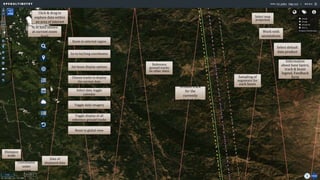
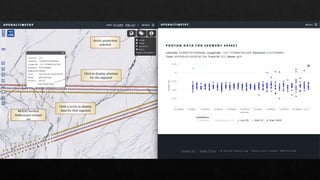
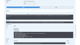
- 3. Ground track for the currently selected date Reference ground tracks on other dates Sampling of segments for each beam Select map projection Work with annotations Information about base layers, track & beam legend, Feedback form Zoom to selected region Go to lat/long coordinates Set beam display options Choose tracks to display for current date Select date, toggle calendar Toggle daily imagery Toggle display of all reference ground tracks Reset to global view Distance scale Date of displayed data % of data shown at current zoom level Click & drag to explore data within an area of interest Coordinates under cursor Select default data product
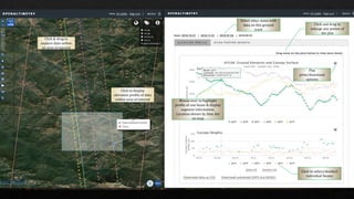
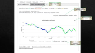
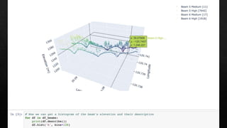
- 4. Select other dates with data on this ground track Click and drag to enlarge any potion of the plot Click to select/deselect individual beams Plot print/download options Click to display elevation profile of data within area of interest Click & drag to explore data within an area of interest Mouse-over to highlight profile of one beam & display segment information. Location shown by blue dot on map
- 5. Click to select which confidence categories to display Click to select which beam to display Plot print/download options Click and drag to enlarge any potion of the plot
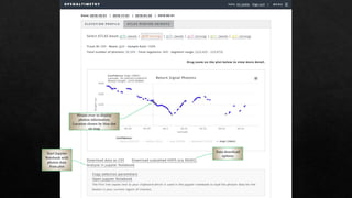
- 6. Mouse-over to display photon information. Location shown by blue dot on map Data download options Start Jupyter Notebook with photon data from plot
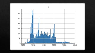
- 7. Click a circle to display data for that segmentMODIS Surface Reflectance turned on Arctic projection selected Click to display photons for the segment