Our country in numbers
- 1. Our country in numbers Hungary
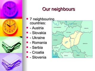
- 2. Our neighbours ïŪ 7 neighbouring countries: ïŪ - Austria ïŪ - Slovakia ïŪ - Ukraine ïŪ - Romania ïŪ - Serbia ïŪ - Croatia ïŪ - Slovenia
- 3. Geographycal facts ïŪ Location: 45°45â-48°35â N 16°05â-22°55â E ïŪ Territory: 93.030 kmÂē ïŪ The territory of Hungary is 1% of Europe ïŪ Length of its border: 2242 km
- 4. Before the Treaty of Trianon ïŪ The territory was 282.870 kmÂē ïŪ It had 64 counties ïŪ In 1920 Hungary lost 71% of its territory and 66% of its population
- 5. Population ïŪ 10,2 million ïŪ 82th place in the list of countries by population ïŪ Density: 118/ kmÂē ïŪ The biggest city and capital, Budapest has 1.7 million inhabitants
- 6. Lake Balaton ïŪ The biggest lake of Central Europe is Lake Balaton. Its territory is 591 kmÂē, length is 78 kms and width is 12-15 kms. The maximum temperature of water can reach 28-29°C.
- 7. Rivers and mountains ïŪ Two main rivers: Duna (Danube-417 kms) and Tisza (597kms) ïŪ The highest point is KÃĐkestetÅ, 1014m in MÃĄtra mountains
- 8. 160 gold medals won on Olympic Games
- 9. ïŪ The village that has got the longest name is NYUGOTIFELSÅSZOMBATFALVA 24 CHARACTERS
- 10. Our currency â lots of zeros!!! 1 euro = 315 HUF
- 11. KÅtelek Population is 1600 people 1 church 1 primary school 1 post office
- 12. The primary school ïŪ It has got 120 pupils ïŪ There are 8 classes ïŪ It has got 11 teachers ïŪ It has got 12 classrooms ïŪ Pupils have 5 or 6 lessons a day ïŪ Lessons are 45 minutes ïŪ Breaks are 15 minutes


