
power point presentation in Abuja
- 1. JIDET NIGERIA LIMITED COAL TO POWER PROJECT PRESENTEDBY FALAE PHILIPSOMOWUMI GEOLOGIST/PROJECT MANAGER
- 2. COMPANY INTRODUCTION JIDET Nigeria Limited is a leading name in Solid and Industrial Minerals Exploration and Mining with an attractive portfolio of coal (Lignite), Gold and Kaolin. We are a limited liability company registered with Corporate Affairs Commission with the head office located at No 26 Idi-ishin main avenue Jericho Reservation area, Ibadan Oyo state. Our vision which is to become the leading producer of Solid and Industrial minerals in Africa, which is the driving force that defines how we conduct our business as a leading producer of coal to power generation in Africa.
- 3. INTRODUCTION ’āÆ This presentation content details of reconnaissance survey, Geological mapping, Laboratory Analysis, and core drilling reports of the lignite. The area of interest in which the Economic mineral potential (Coal) is investigated is in Uhunmwode LGA of Edo state.
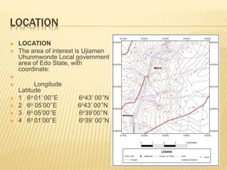
- 4. LOCATION ’āÆ LOCATION ’āÆ The area of interest is Ujiamen Uhunmwonde Local government area of Edo State, with coordinate: ’āÆ ’āÆ Longitude Latitude ’āÆ 1 6o 01ŌĆÖ 00ŌĆÖŌĆÖE 6o43ŌĆÖ 00ŌĆÖŌĆÖN ’āÆ 2 6o 05ŌĆÖ00ŌĆÖŌĆÖE 6o43ŌĆÖ 00ŌĆÖŌĆÖN ’āÆ 3 6o 05ŌĆÖ00ŌĆÖŌĆÖE 6o39ŌĆÖ00ŌĆÖŌĆÖN ’āÆ 4 6o 01ŌĆÖ00ŌĆÖŌĆÖE 6o39ŌĆÖ 00ŌĆÖŌĆÖN
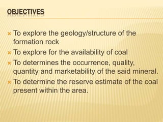
- 5. OBJECTIVES ’āÆ To explore the geology/structure of the formation rock ’āÆ To explore for the availability of coal ’āÆ To determines the occurrence, quality, quantity and marketability of the said mineral. ’āÆ To determine the reserve estimate of the coal present within the area.
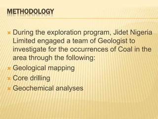
- 6. METHODOLOGY ’āÆ During the exploration program, Jidet Nigeria Limited engaged a team of Geologist to investigate for the occurrences of Coal in the area through the following: ’āÆ Geological mapping ’āÆ Core drilling ’āÆ Geochemical analyses
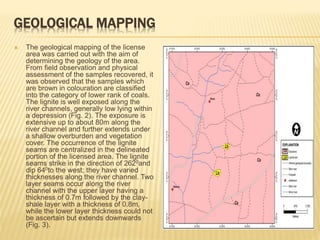
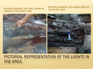
- 7. GEOLOGICAL MAPPING ’āÆ The geological mapping of the license area was carried out with the aim of determining the geology of the area. From field observation and physical assessment of the samples recovered, it was observed that the samples which are brown in colouration are classified into the category of lower rank of coals. The lignite is well exposed along the river channels, generally low lying within a depression (Fig. 2). The exposure is extensive up to about 80m along the river channel and further extends under a shallow overburden and vegetation cover. The occurrence of the lignite seams are centralized in the delineated portion of the licensed area. The lignite seams strike in the direction of 2620and dip 640to the west; they have varied thicknesses along the river channel. Two layer seams occur along the river channel with the upper layer having a thickness of 0.7m followed by the clay- shale layer with a thickness of 0.8m, while the lower layer thickness could not be ascertain but extends downwards (Fig. 3).
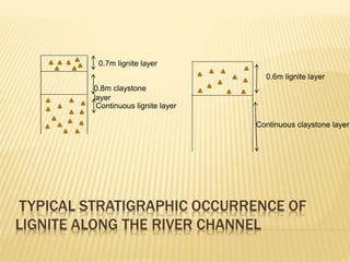
- 8. TYPICAL STRATIGRAPHIC OCCURRENCE OF LIGNITE ALONG THE RIVER CHANNEL 0.7m lignite layer 0.8m claystone layer Continuous lignite layer 0.6m lignite layer Continuous claystone layer
- 9. PICTORIAL REPRESENTATION OF THE LIGINTE IN THE AREA. PICTURE SHOWING THE TWO LAYERS OF LIGNITE IN THE STUDY AREA PICTURE SHOWING THE LIGNITE BODY IN THE STUDY AREA
- 10. CORE DRILLING ’āÆ The drilling programme on the license area on EL 14643 in Ujiamenin Uhunmwonde Local government area of Edo State commenced after the presentation of the report of the geological mapping. The recommended points of drilling as indicated on the map, first aim at drilling within the area of concentration of the coal while the drilling is extended to the other areas. The total area of the concentration of the coal is about 4.94kmsq. The area of concentration of the coal was well grid according to the geological report and twenty (20) drilling points were located with the aid of GPS. The drilling diameter is 52mm while the drilling depth is 40m. During the drilling operations, the lithological arrangement commonly encountered within the area includes: ’āÆ Sandstone of different colour which ranges from brown, yellowish, reddish and whitish ’āÆ Clay stone ’āÆ Clay ŌĆō shale ’āÆ Coal
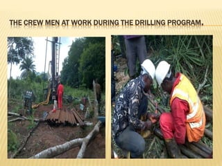
- 11. THE CREW MEN AT WORK DURING THE DRILLING PROGRAM.
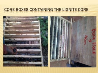
- 12. CORE BOXES CONTAINING THE LIGNITE CORE
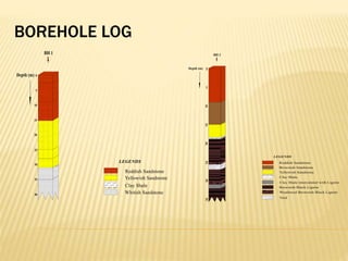
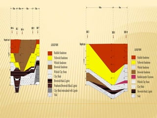
- 13. BOREHOLE LOG
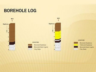
- 14. BOREHOLE LOG
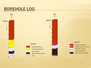
- 15. BOREHOLE LOG
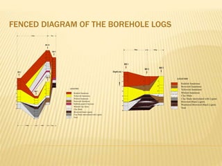
- 16. FENCED DIAGRAM OF THE BOREHOLE LOGS
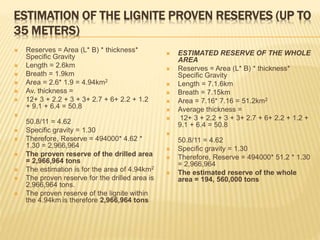
- 18. ESTIMATION OF THE LIGNITE PROVEN RESERVES (UP TO 35 METERS) ’āÆ Reserves = Area (L* B) * thickness* Specific Gravity ’āÆ Length = 2.6km ’āÆ Breath = 1.9km ’āÆ Area = 2.6* 1.9 = 4.94km2 ’āÆ Av. thickness = ’āÆ 12+ 3 + 2.2 + 3 + 3+ 2.7 + 6+ 2.2 + 1.2 + 9.1 + 6.4 = 50.8 ’āÆ 50.8/11 = 4.62 ’āÆ Specific gravity = 1.30 ’āÆ Therefore, Reserve = 494000* 4.62 * 1.30 = 2,966,964 ’āÆ The proven reserve of the drilled area = 2,966,964 tons ’āÆ The estimation is for the area of 4.94km2 ’āÆ The proven reserve for the drilled area is 2,966,964 tons. ’āÆ The proven reserve of the lignite within the 4.94km is therefore 2,966,964 tons ’āÆ ESTIMATED RESERVE OF THE WHOLE AREA ’āÆ Reserves = Area (L* B) * thickness* Specific Gravity ’āÆ Length = 7.1.6km ’āÆ Breath = 7.15km ’āÆ Area = 7.16* 7.16 = 51.2km2 ’āÆ Average thickness = ’āÆ 12+ 3 + 2.2 + 3 + 3+ 2.7 + 6+ 2.2 + 1.2 + 9.1 + 6.4 = 50.8 ’āÆ 50.8/11 = 4.62 ’āÆ Specific gravity = 1.30 ’āÆ Therefore, Reserve = 494000* 51.2 * 1.30 = 2,966,964 ’āÆ The estimated reserve of the whole area = 194, 560,000 tons
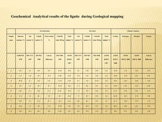
- 19. Air dried basis Dry basis Ultimate Analyses Sample name Inherent moisture % Ash content % Volatile matters % Fixed carbon % Calorific value MJ.kg Total sulphur % Ash content % Volatile matters % Calorific value MJ.kg Total sulphur % Carbon Hydrogen Nitrogen Oxygen SABS 925: 1978 ISO 1171: 1997 ISO 562: 1998 Calc by Difference ISO 1928: 1995 ASTM D4239: 1997 ISO 1171: 1997 ISO 562: 1998 ISO 1928: 1995 ASTM D4239: 1997 ASTM D5373: 2008 ASTM D5373: 2008 ASTM D5373: 2008 Calc by Difference 1 20.1 6.6 48.5 26.7 22.66 0.48 6.0 6.03 29.8 0.6 59.42 5.18 0.85 6.93 2 31.3 144 39.5 18.8 16.84 0.44 17.8 58.7 22.6 0.6 49.03 3.58 0.81 4.01 3 30.25 6.7 42.5 25.2 21.59 0.38 8.5 58.3 29.35 0.6 58.41 6.45 0.84 5.83 4 22.5 8.2 45.4 25.1 22.49 0.42 6.7 60.1 28.7 0.6 49.42 5.85 0.78 6.92 5 20.7 6.1 48.2 22.1 23.61 0.43 7.2 59.2 26.5 0.5 61.31 5.92 0.81 6.54 6 21.4 5.4 46.1 19.5 24.1 0.44 7.1 58.7 29.2 0.6 60.25 6.01 0.74 4.98 7 20.2 5.3 45.2 25.1 16.5 0.41 6.85 60.1 29.5 0.5 61.11 4.58 0.79 5.75 8 20.4 5.4 44.3 19.2 19.89 0.43 7.52 60.2 23.1 0.6 60.21 4.89 0.85 5.92 9 28.2 10.2 40.1 18.5 15.85 0.47 16.2 59.2 21.6 0.7 48.2 4.21 0.81 3.98 Geochemical Analytical results of the lignite during Geological mapping
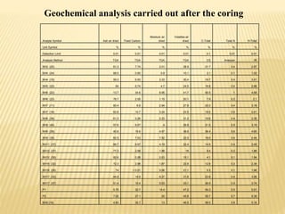
- 20. Analyte Symbol Ash air dried Fixed Carbon Moisture air dried Volatiles air dried C-Total Total N H-Total Unit Symbol % % % % % % % Detection Limit 0.01 0.01 0.01 0.01 0.1 0.01 0.01 Analysis Method TGA TGA TGA TGA CS Analyzer IR BH2 (25) 61.3 7.74 2.01 28.9 21.7 0.4 2.97 BH4 (24) 88.5 0.65 0.8 10.1 2.1 0.1 1.02 BH4 (19) 59.3 6.93 3.33 30.4 19.7 0.4 3.01 BH5 (22) 64 6.74 4.7 24.5 16.8 0.4 2.68 BH6 (22) 13.7 34.6 9.95 41.7 50.5 1 4.58 BH6 (23) 76.7 2.05 1.15 20.1 7.9 0.2 2.1 BH7 (11) 60.4 8.9 2.94 27.8 20.3 0.4 3.18 BH7 (18) 62.6 10.7 3.24 23.5 18.5 0.5 2.41 BH8 (38) 61.3 5.26 2.23 31.2 19.6 0.4 3.35 BH8 (40) 57.6 8.57 4 29.8 21.5 0.5 3.19 BH9 (38) 40.8 15.6 4.97 38.6 36.4 0.6 4.65 BH9 (35) 62.5 7.53 7.52 22.5 16.6 0.4 2.44 BH11 (37) 66.7 6.67 4.19 22.4 14.9 0.4 2.49 BH12 (37) 77.3 2.68 1.98 18 9.4 0.2 1.88 BH12 (39) 82.6 0.28 2.03 15.1 4.1 0.1 1.54 BH16 (32) 72.3 2.98 1.87 22.9 12.9 0.3 2.34 BH16 (39) 74 < 0.01 5.06 21.1 5.3 0.1 1.86 BH17 (32) 44.9 14.9 8.37 31.8 23.8 0.4 3.08 BH17 (37) 51.4 10.4 5.03 33.1 26.9 0.5 3.74 P1 5.75 32.7 14.4 47.2 54.3 0.5 5.61 P2 7.02 27.1 20 45.8 50.7 0.7 5.39 BH5 (19) 4.83 35.7 13 46.5 56.5 0.9 5.18 Geochemical analysis carried out after the coring
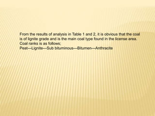
- 21. From the results of analysis in Table 1 and 2, it is obvious that the coal is of lignite grade and is the main coal type found in the license area. Coal ranks is as follows; Peat---Lignite---Sub bituminous---Bitumen---Anthracite
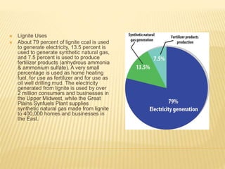
- 22. ’āÆ Lignite Uses ’āÆ About 79 percent of lignite coal is used to generate electricity, 13.5 percent is used to generate synthetic natural gas, and 7.5 percent is used to produce fertilizer products (anhydrous ammonia & ammonium sulfate). A very small percentage is used as home heating fuel, for use as fertilizer and for use as oil well drilling mud. The electricity generated from lignite is used by over 2 million consumers and businesses in the Upper Midwest, while the Great Plains Synfuels Plant supplies synthetic natural gas made from lignite to 400,000 homes and businesses in the East.
- 23. WHAT NEXT ’āś COAL MINING ’é¦ Opening up ’é¦ Equipment ’é¦ Mines layout & plan ’āś COAL FIRE POWER PROJECT ’āś PPA, TCN CONNECTION, POWER LICENCE, ’āś EPC, O&M, OEM ’āś TRANSMISSION ’āÆ COMMUNITY REALATED ISSUE ’é¦ Singing of MoUs ’é¦ Payment of Land owner
- 24. CONCUSION AND RECOMMEDATIONS ’āÆ The lignite occurrence proven reserve in an area of 4.96sq km is estimated to be 2,966,964 tons and an estimated reserve of 194, 560,000 tons ’āÆ The area, from literature, and previous studies has multiple seams of lignite (about 3, up to about 200m) from preliminary geological investigation and previous geophysical configurations of the Tertiary lignite series. ’āÆ The lignite in the area is mineable and economical ’āÆ Further drilling is ongoing to the depth of 80m to confirm the availability of other lignite seam within the drilled area. ’āÆ Appropriate geochemical analysis will also be carried out to determine the quality of the lignite with depth. ’āÆ With the depth of the over burden range between 18 and 35m, open cast mining will therefore be suitable for the mining of the lignite in the area. ’āÆ During mining programme, caution will be taken considering the topography of the area. Appropriate impact assessment of the area is ongoing before the commencement of the mining of the lignite proper. ’āÆ The lignite within the area is enough to generate the proposed 1000mwatt of electricity. And if we utilized 3,000,000 per annum, it is expected that. the project will last for an average of 67years.