Predicting Future Growth from Unbuilt Lots
Download as pptx, pdf2 likes782 views

The document provides an overview of population growth and development trends in Jefferson County, highlighting the increase in residential lots approved prior to the onset of impact fees and the housing market downturn. It outlines the creation of an unbuilt lots map and database to understand and assess the potential for future development based on existing approvals. The document also discusses the ongoing planning processes, including the Envision Jefferson 2035 plan, which aims to provide a future land use map and better align development with infrastructural capacity.


Predicting Future Growth from Unbuilt Lots
- 1. Predicting Future Growth from Unbuilt Lots Chris Whittaker-Jefferson County Planning and Zoning Departments Clay Raines-Jefferson County Planning and Zoning Departments
- 2. Background Information • Growth of Jefferson County’s population – 49% population growth between 1990 and 2010 (from 35,926 residents in 1990 to 53,498 in 2010) • In early 2000’s, over 1,000 residential lots per year were approved by the Jefferson County Planning Commission • Large number of building permits obtained in early 2000’s in Jefferson County – Peaked in 2003, just before impact fees were enacted. • Impact fees pay for needed infrastructure required by new development • In Jefferson County: Schools, Parks, Police, and Fire Services. • Slightly more than $13,000 per typical single family home
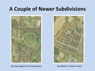
- 4. A Couple of Newer Subdivisions Huntfield in Charles TownBreckenridge North Subdivision
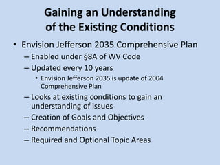
- 5. Gaining an Understanding of the Existing Conditions • Envision Jefferson 2035 Comprehensive Plan – Enabled under §8A of WV Code – Updated every 10 years • Envision Jefferson 2035 is update of 2004 Comprehensive Plan – Looks at existing conditions to gain an understanding of issues – Creation of Goals and Objectives – Recommendations – Required and Optional Topic Areas
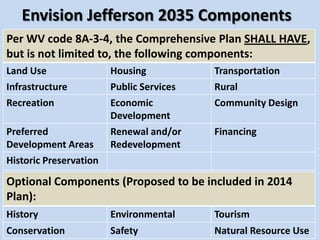
- 6. Envision Jefferson 2035 Components Per WV code 8A-3-4, the Comprehensive Plan SHALL HAVE, but is not limited to, the following components: Land Use Housing Transportation Infrastructure Public Services Rural Recreation Economic Development Community Design Preferred Development Areas Renewal and/or Redevelopment Financing Historic Preservation 6 Optional Components (Proposed to be included in 2014 Plan): History Environmental Tourism Conservation Safety Natural Resource Use
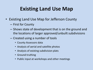
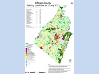
- 7. Existing Land Use Map • Existing Land Use Map for Jefferson County – First for County – Shows state of development that is on the ground and the locations of larger approved/unbuilt subdivisions – Created using a number of tools • County Assessors data • Analysis of aerial and satellite photos • Analysis of existing subdivision plats • Ground truthing • Public input at workshops and other meetings
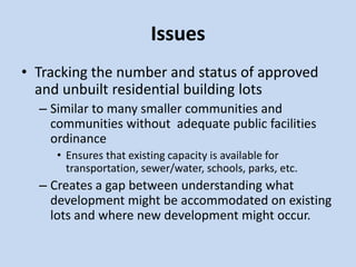
- 9. Issues • Tracking the number and status of approved and unbuilt residential building lots – Similar to many smaller communities and communities without adequate public facilities ordinance • Ensures that existing capacity is available for transportation, sewer/water, schools, parks, etc. – Creates a gap between understanding what development might be accommodated on existing lots and where new development might occur.
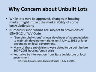
- 10. Why Concern about Unbuilt Lots • While lots may be approved, changes in housing market might impact the marketability of some lots/subdivisions • Numerous subdivisions are subject to provisions of §8A-5-12 of WV Code – “Zombie subdivisions” allows developer of approved plats to maintain development rights until July 1, 2012 or later depending on local government. – Many of these subdivisions were slated to be built before 2007-2008 housing/credit crisis – Kept alive by intervention from State Legislature or local government • Jefferson County extended cutoff date is July 1, 2015
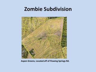
- 11. Zombie Subdivision Aspen Greens, Located off of Flowing Springs Rd.
- 12. What we are doing? • Creating a map and database showing all unbuilt residential and non-residential lots in major and minor subdivisions • Assessing potential build-out of Jefferson County based on approved and unbuilt residential and non-residential lots
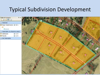
- 13. Creation of Unbuilt Lots Map
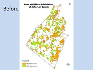
- 14. The Start • Working from an existing subdivisions database created by Meghan Hammond a previous intern. • The majority of the subdivisions were completed in phases, and each record was recorded in sequence – This means my records originally started as nearly 650 major subdivision polygons and 1300 minor subdivisions
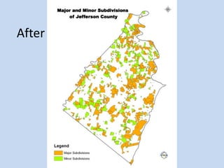
- 15. Trimming the Fat • Needed to reduce the workload and volume, but need to maintain record keeping functionality • Elected to merge records of same subdivision, and keep the most recent planfile • This reduced the number of records as well as the polygons that needed examined
- 17. After
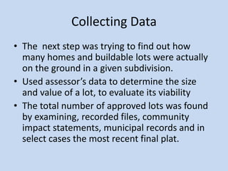
- 18. Collecting Data • The next step was trying to find out how many homes and buildable lots were actually on the ground in a given subdivision. • Used assessor’s data to determine the size and value of a lot, to evaluate its viability • The total number of approved lots was found by examining, recorded files, community impact statements, municipal records and in select cases the most recent final plat.
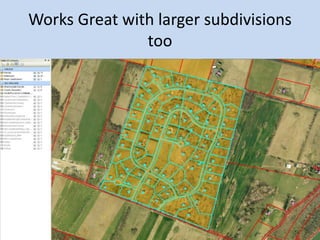
- 21. Works Great with larger subdivisions too
- 22. The “Mountain” • The previous strategy worked about 95% of the time, until I encountered the lots on the Mountain • Here a new, more tedious strategy was adopted. • Moving alphabetically, I applied the same strategy as with the traditional subdivisions, except adopting stricter guidelines on lot size (depending on location of the subdivision)
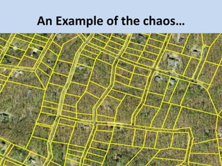
- 23. An Example of the chaos…
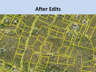
- 24. After Edits
- 25. Worthwhile process • Started with nearly 6,000 parcels • Reduced to under 3,000 by removing parcels unsuitable for building • Proceeded to count the remaining lots and addressed homes on the mountain to obtain the last of my data
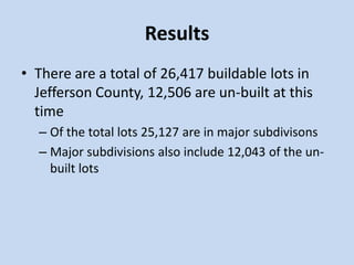
- 26. Results • There are a total of 26,417 buildable lots in Jefferson County, 12,506 are un-built at this time – Of the total lots 25,127 are in major subdivisons – Major subdivisions also include 12,043 of the un- built lots
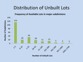
- 27. Distribution of Unbuilt Lots 115 20 34 18 11 13 5 3 2 0 20 40 60 80 100 120 140 NumberofSubdivisions Number of Unbuilt Lots Frequency of Available Lots in major subdivisions
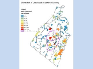
- 28. Lots Available
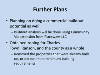
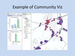
- 29. Further Plans • Planning on doing a commercial buildout potential as well – Buildout analysis will be done using Community Viz extension from Placeways LLC • Obtained zoning for Charles Town, Ranson, and the county as a whole – Removed the properties that were already built on, or did not meet minimum building requirements
- 30. Example of Community Viz
- 31. Applicability of unbuilt lot data • Aid in subdivision and land use process • Key component of Envision Jefferson 2035 document • Use to assess viability of population/employment projections – WVU Bureau of Business and Economic Research – Metro Washington Council of Governments – Hagerstown/Eastern Panhandle MPO – Projection based on 2010-2012 Census growth
- 33. Future Land Use Map • Guide to help developers and public better understand where growth is targeted over the next two decades • Provides greater clarity in comparison to interpretation of descriptions. • Based on data and public input • Helps staff to better understand where zoning changes might be warranted.
- 34. Timeline • Finalization of unbuilt lots (including non- residential lots) by late August • Draft Future Land Use Map to be completed by early 2014 • Final Future Land Use Map will be included with Envision Jefferson 2035 Comprehensive Plan, to be completed by the end of 2014
- 35. More Information • Envision Jefferson 2035 – www.envisionjefferson2035.com • Jefferson County Planning and Zoning – http://www.jeffersoncountywv.org/government/d epartments/planning-and-zoning- department.html
- 36. Thanks for your time
- 37. Questions?
Editor's Notes
- #7: Required component of WV Code 8APlan document prepared under direction of Planning Commission and County Commission -- Role of Steering CommitteeLays out a vision and sets forth policies for future development of the entire County -- Goals and ObjectivesOngoing input from citizens and community leadersBased on data inventory, analysis, and evaluation - Existing Conditions Includes existing and future land use maps and shows future growth areasServes as guide for community decisionsProvides policy and program guidance to decision-makersAccomplishes a coordinated and compatible development of land and improvements (i.e., land development regulations)Must be updated every 10 years
- #27: Editited it atleast twice in the presentation