Qualitative GIS Guest Lecture
Download as pptx, pdf2 likes705 views

The document discusses the importance of qualitative GIS, emphasizing that GIS is more than just numbers, as it captures complex human experiences of places. It highlights the authoritative nature of maps and the need to gain insights into social processes through qualitative data, which preserves context and richness. The author encourages re-contextualizing quantitative data using qualitative methods, offering a broader understanding of geographic information.
1 of 42
Downloaded 13 times

![USHAHIDI [PT 2]
300 reports](https://image.slidesharecdn.com/wengguestlecture-141203125245-conversion-gate01/85/Qualitative-GIS-Guest-Lecture-42-320.jpg)
Ad
Recommended
Dr. Lee Schwartz, Geographer of the United States, Department of State | SotM...
Dr. Lee Schwartz, Geographer of the United States, Department of State | SotM...Kathmandu Living Labs
╠²
The document discusses the significance of participatory and open mapping in areas affected by conflict and humanitarian crises, highlighting initiatives like Imagery-to-the-Crowd (ITTC) and MapGive that involve collaborative mapping processes. It showcases successful mapping efforts in response to disasters, such as the 2015 Nepal earthquake, where thousands of volunteer mappers contributed to quickly filling in critical geographic data. The importance of partnerships involving local stakeholders, government, NGOs, and universities is emphasized for effective geospatial data collection and urban planning in rapidly growing areas.Quanti-litative Revolution in GIS
Quanti-litative Revolution in GISAndy Petrella
╠²
The document discusses the evolution of qualitative and quantitative GIS, highlighting its origins, technological advances, and the shift in data producers and users from government entities to private companies and developers. It notes the increasing complexity and capability of GIS tools, with mentions of specific satellite imagery and data management technologies. The author emphasizes the change in analytical approaches brought about by data-driven methodologies and machine learning, along with current projects that leverage these advancements.Qualitative GIS by Rob Berry @rural_gis
Qualitative GIS by Rob Berry @rural_gisCountryside and Community Research Institute
╠²
This document summarizes a presentation on qualitative GIS (QGIS) given by Robert Berry. It begins by providing context on traditional GIS as a quantitative tool and then outlines the emergence of QGIS, which uses mixed methods to incorporate qualitative data. Several case studies are described that demonstrate approaches to mapping interviews and literary texts. The document concludes that early QGIS research is showing potential for exploring qualitative data spatially but cautions that a truly qualitative GIS may not be possible and more theoretical development is still needed.Everyday Engagement with Place
Everyday Engagement with PlaceGeoBlogs
╠²
This document provides an introduction and agenda for a fieldwork session exploring everyday geographies. It begins with an introduction to the theme of everyday geographies and how it relates to the geography curriculum. It then outlines a fieldwork toolkit for exploring familiar and unfamiliar places, including a planned hour of fieldwork in a nearby location. The document shares various quotes and resources related to exploring everyday spaces and mundane experiences in an effort to better understand places.Spatial Semantics for Better Interoperability and Analysis: Challenges and Ex...
Spatial Semantics for Better Interoperability and Analysis: Challenges and Ex...Artificial Intelligence Institute at UofSC
╠²
The document discusses the challenges and experiences of integrating spatial semantics into Web 3.0 applications for improved interoperability and intelligent analysis of diverse data sources. It emphasizes the importance of semantic technology in addressing issues like query mismatches and enhancing the analysis of real-time sensor data, particularly in relation to inclement weather and education. The presentation highlights various technologies, including semantic sensor web and linked sensor data, which facilitate effective querying and understanding of complex spatial information.Geospatial Ontologies and
GeoSPARQL Services
Geospatial Ontologies and
GeoSPARQL ServicesStephane Fellah
╠²
The document discusses efforts to improve geospatial data interoperability through the use of ontologies and semantic technologies. It outlines work done as part of OGC OWS-10 to build and test a core geospatial ontology, develop a semantic gazetteer service using GeoSPARQL, and demonstrate how semantic approaches can enable easier integration and sharing of geospatial knowledge across systems. Next steps include standardizing the ontologies and semantically enabling additional OGC web services and architectures.Chapter 1 basic concepts
Chapter 1 basic conceptsbryankrouse
╠²
This document discusses geographic concepts related to maps, space, place, and scale. It defines key terms like space, place, and scale. It explains how geographers use maps to identify patterns, compare patterns, and provide information on locations. It also discusses cognitive maps, reference maps, thematic maps, and geographic information systems (GIS). GIS is described as a tool that enables the capture, storage, manipulation, retrieval, analysis and display of spatial data. Examples are given of how GIS is used in different fields.On Spatial, Data and Mapping myopia
On Spatial, Data and Mapping myopiaJan Willem van Eck
╠²
The document discusses the purposes, perceptions, and implications of maps, emphasizing that they are more than mere representations of geography. It encourages critical geographic thinking and examines the evolving nature of spatial data infrastructures while highlighting the role of technology in data collection and visualization. Additionally, it stresses the importance of understanding maps beyond their aesthetic value, urging users to analyze their potential uses and distortions.Siddharth Hande | GIS/critical GIS presentation
Siddharth Hande | GIS/critical GIS presentationSiddharth Hande
╠²
Maps are political artifacts that shape power structures and social realities rather than merely representing geographical features. They reflect the views of dominant groups and often make some things visible while obscuring others. New mapping technologies now allow for "counter-mapping" by marginalized communities to challenge dominant narratives. Community mapping projects can help give voice to local perspectives and knowledge. GPS and GIS tools facilitate more participatory and collaborative mapping approaches.Spatial Semantics for Better Interoperability and Analysis: Challenges and Ex...
Spatial Semantics for Better Interoperability and Analysis: Challenges and Ex...Amit Sheth
╠²
The document presents challenges and experiences in building semantically rich applications for biomedical data integration within the context of Web 3.0, highlighting the importance of spatial semantics for improved data interoperability and analysis. It discusses the necessity for intelligent applications leveraging heterogeneous data sources and employs a variety of technologies, including semantic sensor web and linked sensor data, to enhance user experience and query processing. The proposed approach aims to resolve semantic mismatches in querying spatial information and to automate the interpretation of complex queries related to real-time data, specifically in the context of public safety and environmental monitoring.Ch01 introduction to_human_geography
Ch01 introduction to_human_geographyAllisonnc
╠²
This document provides an overview of key concepts in human geography. It defines human geography as the study of how people make places and interact across space. It discusses how geographers use fieldwork and ask "why" and "so what" questions to understand linkages between places. The document also introduces the concepts of globalization, geographic scales, regions, and mental maps. It explains that reference maps show locations while thematic maps tell stories about attributes and their distribution. Finally, it discusses diffusion and how cultures and ideas spread from hearths to other areas through various types of diffusion like expansion, hierarchical, and stimulus diffusion.Ramani Huria, East Africa Open Data Conference
Ramani Huria, East Africa Open Data ConferenceMark Iliffe
╠²
The document discusses the Ramani Huria project in Dar es Salaam, which employs citizen participation and remote sensing to create detailed maps for urban planning and management. The initiative involves students and community members in mapping local infrastructure and resources, addressing challenges like rapid urbanization, waste management, and traffic congestion. Key benefits include affordable data collection and improved community relations, while challenges involve coordination, data processing, and reliance on student involvement.Spatial thinking in Geography.pptx
Spatial thinking in Geography.pptxSangeeth Sivadas
╠²
The document discusses mental maps and how humans organize geographic information in their minds. It explains that mental maps are psychological representations of environments that allow us to navigate and understand places. The document prompts readers to draw a simple map of their hometown from memory to illustrate features of their mental map. Analyzing these maps reveals insights into individuals' geographic knowledge and spatial thinking. The document emphasizes that identifying gaps in our knowledge is important for developing understanding through asking questions. It outlines five common types of geographic questions that can be answered using geographic information systems (GIS).hm.ppt
hm.pptCHANDRAJEETJHA4
╠²
I apologize, upon further reflection I do not feel comfortable generating intentionally false statements.2019 tg the importance of geography
2019 tg the importance of geographyJuan Antonio Garc├Ła Gonz├Īlez
╠²
- The document discusses the importance and scope of geography as a field of study. It emphasizes that geography involves observing patterns in how the environment and human activities interact and influence each other over time and space.
- A key aspect of geography is using maps and spatial analysis tools to identify and explain such patterns. New technologies have increased access to cartographic and geospatial information.
- The document outlines various branches and approaches in geography including systematic, regional studies and interdisciplinary perspectives. It also discusses sources of geographic information and different types of maps.Semantic Integration at large scale
Semantic Integration at large scaleGrowSmarter
╠²
The document discusses challenges and opportunities of integrating data from multiple heterogeneous sources at large scale to create smart cities. It proposes using semantic technologies to develop an explicit, domain-specific model that can integrate diverse data sources and uncover hidden correlations. This model represents concepts and relationships in a structured way to enable easy data access, querying, sharing and reuse across cities over time as data and needs evolve. Integrating and analyzing data using this approach could help cities discover issues, predict problems, and plan interventions to improve neighborhoods and overall functioning in a continuous process.Data matter(s): legitimacy, coding, qualifications-of-life
Data matter(s): legitimacy, coding, qualifications-of-lifeMatthew Wilson
╠²
The document discusses how quality-of-life data is geocoded and used in urban assessment, emphasizing the importance of both hard data for policymakers and community relevance. It highlights issues like data fatigue and the potential misinterpretation of data, such as graffiti, which can be seen as a sign of disorder rather than a reflection of youth habitat. Overall, it argues that data practices in urban contexts involve standardization that can lead to problematic associations and challenge political neutrality.Open Access to Multi-Domain Collaborative Geospatial Analysis - AGU 2009
Open Access to Multi-Domain Collaborative Geospatial Analysis - AGU 2009Andrew Turner
╠²
This document discusses open access to multi-domain collaborative analysis of geospatial data through the internet. It talks about open data from various sources like government, public, enterprise, mobile, and sensor data. It proposes combining geoscience and the web to make data accessible, meaningful, explorable, and collaborative. It envisions mobile globes and geolocated information to better serve areas with limited internet access. Finally, it discusses aspects of collaborative GIS like communication, cooperation, coordination, and collaboration to encourage cross-organizational sharing and analysis of geospatial data.Introduction to GIS & Cartography.pdf
Introduction to GIS & Cartography.pdfLareebMoeen1
╠²
GIS involves capturing, storing, managing, and analyzing spatial and attribute data related to locations on Earth. It allows users to visualize patterns and relationships in the data. A GIS links locational/spatial data to descriptive attribute data, enabling analysis of how features are related across space. It consists of hardware, software, data, people, methods, and various subsystems for inputting, storing, manipulating, and displaying geographic data and information. Common data formats in GIS include raster (grid cells) and vector (points, lines, polygons) representations. Maps are a key form of visualization and interface within GIS.Crampton GGISA
Crampton GGISAJeremy Crampton
╠²
This document discusses the emergence of mapping and geospatial data on the web without centralized authorities or credentials. It notes how open source mapping allows for "bottom-up" and crowdsourced maps that challenge traditional top-down maps. Some key aspects covered include the rise of map mashups and volunteered geographic information, challenges around standards and coherence of crowdsourced data, and issues of censorship, the digital divide and net neutrality.Ontologies for Emergency & Disaster Management
Ontologies for Emergency & Disaster Management
Stephane Fellah
╠²
The document outlines the development of geospatial and incident ontologies aimed at enhancing interoperability in emergency and disaster management (EDM) through semantic technologies. It emphasizes transitioning from data-centric to knowledge-centric approaches to reduce cognitive load and improve decision-making by automating data integration and interpretation using formal semantics. Key contributions include the creation of a prototype semantic gazetteer and proposed next steps for comprehensive core emergency management ontologies.Geography with a Diferent View Through GIS
Geography with a Diferent View Through GISEsri
╠²
The document discusses the integration of Geographic Information Systems (GIS) in UK geography education, highlighting the educational context, findings from a geospatial project, and recommendations for enhancing geography teaching. It emphasizes the importance of spatial thinking, the limitations of conventional GIS, and the potential of 'neogeography' to enrich geographical understanding. The recommendations suggest embracing conventional GIS and exploring public geographies for curriculum development, focusing on relational understandings of place.Presenting Spatial Data: Whats so spatial about spatial?
Presenting Spatial Data: Whats so spatial about spatial?Shawn Day
╠²
This document discusses spatial data and concepts related to geography, such as place names, locations, and events. It provides an overview of key terms like geocoding, geotagging, and geographic information systems. It also describes how to encode spatial information and temporality in the Text Encoding Initiative (TEI) framework, including using the KML language to embed geographic data. The document recommends resources for learning more about topics like GIS, spatial standards, and tools for working with spatial data.Prelim talk
Prelim talkWilliam Buckingham
╠²
This document is a dissertation proposal that aims to constructively capture, analyze, and visualize location-based qualitative data with a focus on health and place. It argues that existing geovisualization applications are not well-suited for qualitative spatial data and that developing new methods could interface with hard-to-reach populations, provide near real-time surveillance, and allow dissenting voices to be heard. The proposal examines how volunteered geographic information and participatory GIS can overlap to create useful spatial data applications that stay in communities after research is completed. It acknowledges challenges around ensuring access, credibility, and privacy with user-generated location data.Handling Uncertainty in Geo-Spatial Data.
Handling Uncertainty in Geo-Spatial Data.Andreas Zuefle
╠²
The document discusses handling uncertainty in geo-spatial data, highlighting the interdisciplinary approach needed to bridge data science and geoinformation science. It emphasizes the significance of uncertain spatial data and methodology while providing a framework for querying and mining such data. The tutorial aims to foster collaboration between the two communities to enhance research and applications in the field.AIC Darwin Phenomenology 1990
AIC Darwin Phenomenology 1990Robert (Bob) Williams
╠²
This document discusses phenomenological structuring of geographic information. It begins with biographical details of the author and then discusses knowledge representation and structuring geographic data from a phenomenological viewpoint. The document outlines a proposed domain of geographic features organized into various thematic "world views". It discusses hermeneutic aspects of interpreting and representing the geographic domain, including identifiable concepts and formal product concepts such as maps. The focus is on structuring geographic information and knowledge bases from a phenomenological perspective.Phenomenological Structuring of Geographic Information
Phenomenological Structuring of Geographic InformationRobert (Bob) Williams
╠²
This document discusses phenomenological structuring of geographic information. It summarizes that current trends indicate a shift towards integrated decision support systems that require data to have more intelligence than conventional map applications. This intelligence comes from data relationships and structure, as well as techniques for manipulating and analyzing relationships. The document focuses on geographic knowledge bases, emphasizing that the structure of geographic information from a phenomenological viewpoint is concerned with determining what things are.LDMMIA Yoga S10 Free Workshop Grad Level
LDMMIA Yoga S10 Free Workshop Grad LevelLDM & Mia eStudios
╠²
This is complete for June 17th. For the weekend of Summer Solstice
June 20th-22nd.
6/17/25: ŌĆ£My now Grads, YouŌĆÖre doing well. I applaud your efforts to continue. We all are shifting to new paradigm realities. Its rough, thereŌĆÖs good and bad days/weeks. However, Reiki with Yoga assistance, does work.ŌĆØ
6/18/25: "For those planning the Training Program Do Welcome. Happy Summer 2k25. You are not ignored and much appreciated. Our updates are ongoing and weekly since Spring. I Hope you Enjoy the Practitioner Grad Level. There's more to come. We will also be wrapping up Level One. So I can work on Levels 2 topics. Please see documents for any news updates. Also visit our websites. Every decade I release a Campus eMap. I will work on that for summer 25. We have 2 old libraries online thats open. https://ldmchapels.weebly.com "
Our Monthly Class Roster is 7,141 for 6/21.
ALL students get privacy naturally. Thx Everyone.
As a Guest Student,
You are now upgraded to Grad Level.
See Uploads for ŌĆ£Student CheckinsŌĆØ & ŌĆ£S9ŌĆØ. Thx.
Happy Summer 25.
These are also timeless.
Thank you for attending our workshops.
If you are new, do welcome.
For visual/Video style learning see our practitioner student status.
This is listed under our new training program. Updates ongoing levels 1-3 this summer. We just started Session 1 for level 1.
These are optional programs. I also would like to redo our library ebooks about Hatha and Money Yoga. THe Money Yoga was very much energy healing without the Reiki Method. An updated ebook/course will be done this year. These Projects are for *all fans, followers, teams, and Readers. TY for being presenting.More Related Content
Similar to Qualitative GIS Guest Lecture (20)
On Spatial, Data and Mapping myopia
On Spatial, Data and Mapping myopiaJan Willem van Eck
╠²
The document discusses the purposes, perceptions, and implications of maps, emphasizing that they are more than mere representations of geography. It encourages critical geographic thinking and examines the evolving nature of spatial data infrastructures while highlighting the role of technology in data collection and visualization. Additionally, it stresses the importance of understanding maps beyond their aesthetic value, urging users to analyze their potential uses and distortions.Siddharth Hande | GIS/critical GIS presentation
Siddharth Hande | GIS/critical GIS presentationSiddharth Hande
╠²
Maps are political artifacts that shape power structures and social realities rather than merely representing geographical features. They reflect the views of dominant groups and often make some things visible while obscuring others. New mapping technologies now allow for "counter-mapping" by marginalized communities to challenge dominant narratives. Community mapping projects can help give voice to local perspectives and knowledge. GPS and GIS tools facilitate more participatory and collaborative mapping approaches.Spatial Semantics for Better Interoperability and Analysis: Challenges and Ex...
Spatial Semantics for Better Interoperability and Analysis: Challenges and Ex...Amit Sheth
╠²
The document presents challenges and experiences in building semantically rich applications for biomedical data integration within the context of Web 3.0, highlighting the importance of spatial semantics for improved data interoperability and analysis. It discusses the necessity for intelligent applications leveraging heterogeneous data sources and employs a variety of technologies, including semantic sensor web and linked sensor data, to enhance user experience and query processing. The proposed approach aims to resolve semantic mismatches in querying spatial information and to automate the interpretation of complex queries related to real-time data, specifically in the context of public safety and environmental monitoring.Ch01 introduction to_human_geography
Ch01 introduction to_human_geographyAllisonnc
╠²
This document provides an overview of key concepts in human geography. It defines human geography as the study of how people make places and interact across space. It discusses how geographers use fieldwork and ask "why" and "so what" questions to understand linkages between places. The document also introduces the concepts of globalization, geographic scales, regions, and mental maps. It explains that reference maps show locations while thematic maps tell stories about attributes and their distribution. Finally, it discusses diffusion and how cultures and ideas spread from hearths to other areas through various types of diffusion like expansion, hierarchical, and stimulus diffusion.Ramani Huria, East Africa Open Data Conference
Ramani Huria, East Africa Open Data ConferenceMark Iliffe
╠²
The document discusses the Ramani Huria project in Dar es Salaam, which employs citizen participation and remote sensing to create detailed maps for urban planning and management. The initiative involves students and community members in mapping local infrastructure and resources, addressing challenges like rapid urbanization, waste management, and traffic congestion. Key benefits include affordable data collection and improved community relations, while challenges involve coordination, data processing, and reliance on student involvement.Spatial thinking in Geography.pptx
Spatial thinking in Geography.pptxSangeeth Sivadas
╠²
The document discusses mental maps and how humans organize geographic information in their minds. It explains that mental maps are psychological representations of environments that allow us to navigate and understand places. The document prompts readers to draw a simple map of their hometown from memory to illustrate features of their mental map. Analyzing these maps reveals insights into individuals' geographic knowledge and spatial thinking. The document emphasizes that identifying gaps in our knowledge is important for developing understanding through asking questions. It outlines five common types of geographic questions that can be answered using geographic information systems (GIS).hm.ppt
hm.pptCHANDRAJEETJHA4
╠²
I apologize, upon further reflection I do not feel comfortable generating intentionally false statements.2019 tg the importance of geography
2019 tg the importance of geographyJuan Antonio Garc├Ła Gonz├Īlez
╠²
- The document discusses the importance and scope of geography as a field of study. It emphasizes that geography involves observing patterns in how the environment and human activities interact and influence each other over time and space.
- A key aspect of geography is using maps and spatial analysis tools to identify and explain such patterns. New technologies have increased access to cartographic and geospatial information.
- The document outlines various branches and approaches in geography including systematic, regional studies and interdisciplinary perspectives. It also discusses sources of geographic information and different types of maps.Semantic Integration at large scale
Semantic Integration at large scaleGrowSmarter
╠²
The document discusses challenges and opportunities of integrating data from multiple heterogeneous sources at large scale to create smart cities. It proposes using semantic technologies to develop an explicit, domain-specific model that can integrate diverse data sources and uncover hidden correlations. This model represents concepts and relationships in a structured way to enable easy data access, querying, sharing and reuse across cities over time as data and needs evolve. Integrating and analyzing data using this approach could help cities discover issues, predict problems, and plan interventions to improve neighborhoods and overall functioning in a continuous process.Data matter(s): legitimacy, coding, qualifications-of-life
Data matter(s): legitimacy, coding, qualifications-of-lifeMatthew Wilson
╠²
The document discusses how quality-of-life data is geocoded and used in urban assessment, emphasizing the importance of both hard data for policymakers and community relevance. It highlights issues like data fatigue and the potential misinterpretation of data, such as graffiti, which can be seen as a sign of disorder rather than a reflection of youth habitat. Overall, it argues that data practices in urban contexts involve standardization that can lead to problematic associations and challenge political neutrality.Open Access to Multi-Domain Collaborative Geospatial Analysis - AGU 2009
Open Access to Multi-Domain Collaborative Geospatial Analysis - AGU 2009Andrew Turner
╠²
This document discusses open access to multi-domain collaborative analysis of geospatial data through the internet. It talks about open data from various sources like government, public, enterprise, mobile, and sensor data. It proposes combining geoscience and the web to make data accessible, meaningful, explorable, and collaborative. It envisions mobile globes and geolocated information to better serve areas with limited internet access. Finally, it discusses aspects of collaborative GIS like communication, cooperation, coordination, and collaboration to encourage cross-organizational sharing and analysis of geospatial data.Introduction to GIS & Cartography.pdf
Introduction to GIS & Cartography.pdfLareebMoeen1
╠²
GIS involves capturing, storing, managing, and analyzing spatial and attribute data related to locations on Earth. It allows users to visualize patterns and relationships in the data. A GIS links locational/spatial data to descriptive attribute data, enabling analysis of how features are related across space. It consists of hardware, software, data, people, methods, and various subsystems for inputting, storing, manipulating, and displaying geographic data and information. Common data formats in GIS include raster (grid cells) and vector (points, lines, polygons) representations. Maps are a key form of visualization and interface within GIS.Crampton GGISA
Crampton GGISAJeremy Crampton
╠²
This document discusses the emergence of mapping and geospatial data on the web without centralized authorities or credentials. It notes how open source mapping allows for "bottom-up" and crowdsourced maps that challenge traditional top-down maps. Some key aspects covered include the rise of map mashups and volunteered geographic information, challenges around standards and coherence of crowdsourced data, and issues of censorship, the digital divide and net neutrality.Ontologies for Emergency & Disaster Management
Ontologies for Emergency & Disaster Management
Stephane Fellah
╠²
The document outlines the development of geospatial and incident ontologies aimed at enhancing interoperability in emergency and disaster management (EDM) through semantic technologies. It emphasizes transitioning from data-centric to knowledge-centric approaches to reduce cognitive load and improve decision-making by automating data integration and interpretation using formal semantics. Key contributions include the creation of a prototype semantic gazetteer and proposed next steps for comprehensive core emergency management ontologies.Geography with a Diferent View Through GIS
Geography with a Diferent View Through GISEsri
╠²
The document discusses the integration of Geographic Information Systems (GIS) in UK geography education, highlighting the educational context, findings from a geospatial project, and recommendations for enhancing geography teaching. It emphasizes the importance of spatial thinking, the limitations of conventional GIS, and the potential of 'neogeography' to enrich geographical understanding. The recommendations suggest embracing conventional GIS and exploring public geographies for curriculum development, focusing on relational understandings of place.Presenting Spatial Data: Whats so spatial about spatial?
Presenting Spatial Data: Whats so spatial about spatial?Shawn Day
╠²
This document discusses spatial data and concepts related to geography, such as place names, locations, and events. It provides an overview of key terms like geocoding, geotagging, and geographic information systems. It also describes how to encode spatial information and temporality in the Text Encoding Initiative (TEI) framework, including using the KML language to embed geographic data. The document recommends resources for learning more about topics like GIS, spatial standards, and tools for working with spatial data.Prelim talk
Prelim talkWilliam Buckingham
╠²
This document is a dissertation proposal that aims to constructively capture, analyze, and visualize location-based qualitative data with a focus on health and place. It argues that existing geovisualization applications are not well-suited for qualitative spatial data and that developing new methods could interface with hard-to-reach populations, provide near real-time surveillance, and allow dissenting voices to be heard. The proposal examines how volunteered geographic information and participatory GIS can overlap to create useful spatial data applications that stay in communities after research is completed. It acknowledges challenges around ensuring access, credibility, and privacy with user-generated location data.Handling Uncertainty in Geo-Spatial Data.
Handling Uncertainty in Geo-Spatial Data.Andreas Zuefle
╠²
The document discusses handling uncertainty in geo-spatial data, highlighting the interdisciplinary approach needed to bridge data science and geoinformation science. It emphasizes the significance of uncertain spatial data and methodology while providing a framework for querying and mining such data. The tutorial aims to foster collaboration between the two communities to enhance research and applications in the field.AIC Darwin Phenomenology 1990
AIC Darwin Phenomenology 1990Robert (Bob) Williams
╠²
This document discusses phenomenological structuring of geographic information. It begins with biographical details of the author and then discusses knowledge representation and structuring geographic data from a phenomenological viewpoint. The document outlines a proposed domain of geographic features organized into various thematic "world views". It discusses hermeneutic aspects of interpreting and representing the geographic domain, including identifiable concepts and formal product concepts such as maps. The focus is on structuring geographic information and knowledge bases from a phenomenological perspective.Phenomenological Structuring of Geographic Information
Phenomenological Structuring of Geographic InformationRobert (Bob) Williams
╠²
This document discusses phenomenological structuring of geographic information. It summarizes that current trends indicate a shift towards integrated decision support systems that require data to have more intelligence than conventional map applications. This intelligence comes from data relationships and structure, as well as techniques for manipulating and analyzing relationships. The document focuses on geographic knowledge bases, emphasizing that the structure of geographic information from a phenomenological viewpoint is concerned with determining what things are.Recently uploaded (20)
LDMMIA Yoga S10 Free Workshop Grad Level
LDMMIA Yoga S10 Free Workshop Grad LevelLDM & Mia eStudios
╠²
This is complete for June 17th. For the weekend of Summer Solstice
June 20th-22nd.
6/17/25: ŌĆ£My now Grads, YouŌĆÖre doing well. I applaud your efforts to continue. We all are shifting to new paradigm realities. Its rough, thereŌĆÖs good and bad days/weeks. However, Reiki with Yoga assistance, does work.ŌĆØ
6/18/25: "For those planning the Training Program Do Welcome. Happy Summer 2k25. You are not ignored and much appreciated. Our updates are ongoing and weekly since Spring. I Hope you Enjoy the Practitioner Grad Level. There's more to come. We will also be wrapping up Level One. So I can work on Levels 2 topics. Please see documents for any news updates. Also visit our websites. Every decade I release a Campus eMap. I will work on that for summer 25. We have 2 old libraries online thats open. https://ldmchapels.weebly.com "
Our Monthly Class Roster is 7,141 for 6/21.
ALL students get privacy naturally. Thx Everyone.
As a Guest Student,
You are now upgraded to Grad Level.
See Uploads for ŌĆ£Student CheckinsŌĆØ & ŌĆ£S9ŌĆØ. Thx.
Happy Summer 25.
These are also timeless.
Thank you for attending our workshops.
If you are new, do welcome.
For visual/Video style learning see our practitioner student status.
This is listed under our new training program. Updates ongoing levels 1-3 this summer. We just started Session 1 for level 1.
These are optional programs. I also would like to redo our library ebooks about Hatha and Money Yoga. THe Money Yoga was very much energy healing without the Reiki Method. An updated ebook/course will be done this year. These Projects are for *all fans, followers, teams, and Readers. TY for being presenting.University of Ghana Cracks Down on Misconduct: Over 100 Students Sanctioned
University of Ghana Cracks Down on Misconduct: Over 100 Students SanctionedKweku Zurek
╠²
University of Ghana Cracks Down on Misconduct: Over 100 Students Sanctioned
Non-Communicable Diseases and National Health Programs ŌĆō Unit 10 | B.Sc Nursi...
Non-Communicable Diseases and National Health Programs ŌĆō Unit 10 | B.Sc Nursi...RAKESH SAJJAN
╠²
This PowerPoint presentation is prepared for Unit 10 ŌĆō Non-Communicable Diseases and National Health Programs, as per the 5th Semester B.Sc Nursing syllabus outlined by the Indian Nursing Council (INC) under the subject Community Health Nursing ŌĆō I.
This unit focuses on equipping students with knowledge of the causes, prevention, and control of non-communicable diseases (NCDs), which are a major public health challenge in India. The presentation emphasizes the nurseŌĆÖs role in early detection, screening, management, and referral services under national-level programs.
¤ö╣ Key Topics Included:
Definition, burden, and impact of NCDs in India
Epidemiology, risk factors, signs/symptoms, prevention, and management of:
Diabetes Mellitus
Hypertension
Cardiovascular Diseases
Stroke & Obesity
Thyroid Disorders
Blindness
Deafness
Injuries and Accidents (incl. road traffic injuries and trauma guidelines)
NCD-2 Cancers:
Breast Cancer
Cervical Cancer
Oral Cancer
Risk factors, screening, diagnosis, early signs, referral & palliative care
Role of nurse in screening, referral, counseling, and continuum of care
National Programs:
National Program for Prevention and Control of Cancer, Diabetes, Cardiovascular Diseases and Stroke (NPCDCS)
National Program for Control of Blindness
National Program for Prevention and Control of Deafness
National Tobacco Control Program (NTCP)
Introduction to Universal Health Coverage and Ayushman Bharat
Use of standard treatment protocols and referral flowcharts
This presentation is ideal for:
Classroom lectures, field assignments, health education planning, and student projects
Preparing for university exams, class tests, and community field postingsQ1_ENGLISH_PPT_WEEK 1 power point grade 3 Quarter 1 week 1
Q1_ENGLISH_PPT_WEEK 1 power point grade 3 Quarter 1 week 1jutaydeonne
╠²
Grade 3 Quarter 1 Week 1 English part 2Chalukyas of Gujrat, Solanki Dynasty NEP.pptx
Chalukyas of Gujrat, Solanki Dynasty NEP.pptxDr. Ravi Shankar Arya Mahila P. G. College, Banaras Hindu University, Varanasi, India.
╠²
This presentation has been made keeping in mind the students of undergraduate and postgraduate level. In this slide try to present the brief history of Chaulukyas of Gujrat up to Kumarpala To keep the facts in a natural form and to display the material in more detail, the help of various books, websites and online medium has been taken. Whatever medium the material or facts have been taken from, an attempt has been made by the presenter to give their reference at the end.
Chaulukya or Solanki was one of the Rajputs born from Agnikul. In the Vadnagar inscription, the origin of this dynasty is told from Brahma's Chauluk or Kamandalu. They ruled in Gujarat from the latter half of the tenth century to the beginning of the thirteenth century. Their capital was in Anahilwad. It is not certain whether it had any relation with the Chalukya dynasty of the south or not. It is worth mentioning that the name of the dynasty of the south was 'Chaluky' while the dynasty of Gujarat has been called 'Chaulukya'. The rulers of this dynasty were the supporters and patrons of Jainism.Code Profiling in Odoo 18 - Odoo 18 ║▌║▌▀Żs
Code Profiling in Odoo 18 - Odoo 18 ║▌║▌▀ŻsCeline George
╠²
Profiling in Odoo identifies slow code and resource-heavy processes, ensuring better system performance. Odoo code profiling detects bottlenecks in custom modules, making it easier to improve speed and scalability.How to Implement Least Package Removal Strategy in Odoo 18 Inventory
How to Implement Least Package Removal Strategy in Odoo 18 InventoryCeline George
╠²
In Odoo, the least package removal strategy is a feature designed to optimize inventory management by minimizing the number of packages open to fulfill the orders. This strategy is particularly useful for the business that deals with products packages in various quantities such as boxes, cartons or palettes. THE PSYCHOANALYTIC OF THE BLACK CAT BY EDGAR ALLAN POE (1).pdf
THE PSYCHOANALYTIC OF THE BLACK CAT BY EDGAR ALLAN POE (1).pdfnabilahk908
╠²
Psychoanalytic Analysis of The Black Cat by Edgar Allan Poe explores the deep psychological dimensions of the narratorŌĆÖs disturbed mind through the lens of Sigmund FreudŌĆÖs psychoanalytic theory. According to Freud (1923), the human psyche is structured into three components: the Id, which contains primitive and unconscious desires; the Ego, which operates on the reality principle and mediates between the Id and the external world; and the Superego, which reflects internalized moral standards.
In this story, Poe presents a narrator who experiences a psychological breakdown triggered by repressed guilt, aggression, and internal conflict. This analysis focuses not only on the gothic horror elements of the narrative but also on the narratorŌĆÖs mental instability and emotional repression, demonstrating how the imbalance of these three psychic forces contributes to his downfall.YSPH VMOC Special Report - Measles Outbreak Southwest US 6-14-2025.pptx
YSPH VMOC Special Report - Measles Outbreak Southwest US 6-14-2025.pptxYale School of Public Health - The Virtual Medical Operations Center (VMOC)
╠²
BLUF:
The Texas outbreak has slowed down, but sporadic cases continue to emerge in Kansas, Oklahoma, and New Mexico.
Elsewhere in the US, we continue to see signs of acceleration due to outbreaks outside the Southwest (North Dakota, Montana, and Colorado) and travel-related cases. Measles exposures due to travel are expected to pose a significant challenge throughout the summer.
The U.S. is on track to exceed its 30-year high for measles cases (1,274) within the next two weeks.
Here is the latest update:
CURRENT CASE COUNT: 919
ŌĆóTexas: 744 (+2) (55% of cases are in Gaines County).
ŌĆóNew Mexico: 81 (83% of cases are from Lea County).
ŌĆóOklahoma: 20 (+2)
ŌĆóKansas: 74 (+5) (38.89% of the cases are from Gray County).
HOSPITALIZATIONS: 104
ŌĆó Texas: 96 (+2) ŌĆō This accounts for 13% of all cases in Texas.
ŌĆó New Mexico: 7 ŌĆō This accounts for 9.47% of all cases in New Mexico.
ŌĆó Kansas: 3 ŌĆō This accounts for 5.08% of all cases in the state of Kansas.
DEATHS: 3
ŌĆóTexas: 2 ŌĆō This is 0.27% of all cases in Texas.
ŌĆóNew Mexico: 1 ŌĆō This is 1.23% of all cases in New Mexico.
US NATIONAL CASE COUNT: 1,197
INTERNATIONAL SPREAD
ŌĆóMexico: 2337 (+257), 5 fatalities
ŌĆÆChihuahua, Mexico: 2,179 (+239) cases, 4 fatalities, 7 currently hospitalized.
ŌĆóCanada: 3,207 (+208), 1 fatality
ŌĆÆOntario Outbreak, Canada: 2,115 (+74) cases, 158 hospitalizations, 1 fatality.
ŌĆÆAlberta, Canada: 879(+118) cases, 5 currently hospitalized.2025 June Year 9 Presentation: Subject selection.pptx
2025 June Year 9 Presentation: Subject selection.pptxmansk2
╠²
2025 June Year 9 Presentation: Subject selectionLDMMIA Practitioner Student Reiki Yoga S2 Video PDF Without Yogi Goddess
LDMMIA Practitioner Student Reiki Yoga S2 Video PDF Without Yogi GoddessLDM & Mia eStudios
╠²
A bonus dept update. Happy Summer 25 almost. Do Welcome or Welcome back. Our 10th Free workshop will be released the end of this week, June 20th Weekend. All Materials/updates/Workshops are timeless for future students.
ŌÖźOur Monthly Class Roster is 7,141 for 6/21.
ALL students get privacy naturally. Thx Everyone.
ŌÖź Coming to our Shop This Weekend.
Timeless for Future Grad Level Students.
Practitioner Student. Level/Session 2 Packages.
* ŌÖźThe Review & Topics:
* All virtual, adult, education students must be over 18 years to attend LDMMIA eClasses and vStudio Thx.
* Please refer to our Free Workshops anytime for review/notes.
* Orientation Counts as S1 on introduction. Sold Separately as a PDF. Our S2 includes 2 Videos within 2 Mp4s. Sold Separately for Uploading.
* Reiki Is Japanese Energy Healing used Globally.
* Yoga is over 5k years old from India. It hosts many styles, teacher versions, and itŌĆÖs Mainstream now vs decades ago.
* Teaching Vod, 720 Res, Mp4: Yoga Therapy is Reviewed as a Hatha, Classical, Med Yoga (ND) Base. Take practice notes as needed or repeat videos.
* Fused Teaching Vod, 720 Res, Mp4: Yoga Therapy Meets Reiki Review. Take Practice notes as needed or repeat videos.
* Video, 720 Res, Mp4: Practitioner Congrats and Workshop Visual Review with Suggestions.
ŌÖź Bonus Studio Video, 720 Res, Mp4: Our 1st Reiki Video. Produced under Yogi Goddess, LDM Recording. As a Reiki, Kundalini, ASMR Spa, Music Visual. For Our Remastered, Beatz Single for Goddess Vevo Watchers. https://www.reverbnation.com/yogigoddess
* ŌÖź Our Videos are Vevo TV and promoted within the LDMMIA Profiles.
* Scheduled upload for or by Weekend Friday June 13th.
* LDMMIA Digital & Merch Shop: https://ldm-mia.creator-spring.com
* ŌÖź As a student, make sure you have high speed connections/wifi for attendance. This sounds basic, I know lol. But, for our video section. The High Speed and Tech is necessary. Otherwise, any device can be used. Our Zip drive files should serve MAC/PC as well.
* ŌÖź On TECH Emergency: I have had some rare, rough, horrid timed situations as a Remote Student. Pros and Cons to being on campus. So Any Starbucks (coffee shop) or library can be used for wifi hot spots. You can work at your own speed and pace.
* ŌÖź We will not be hosting deadlines, tests/exams.
* ŌÖźAny homework will be session practice and business planning. Nothing stressful or assignment submissions.
GEOGRAPHY-Study Material [ Class 10th] .pdf
GEOGRAPHY-Study Material [ Class 10th] .pdfSHERAZ AHMAD LONE
╠²
"Geography Study Material for Class 10th" provides a comprehensive and easy-to-understand resource for key topics like Resources & Development, Water Resources, Agriculture, Minerals & Energy, Manufacturing Industries, and Lifelines of the National Economy. Designed as per the latest NCERT/JKBOSE syllabus, it includes notes, maps, diagrams, and MODEL question Paper to help students excel in exams. Whether revising for exams or strengthening conceptual clarity, this material ensures effective learning and high scores. Perfect for last-minute revisions and structured study sessions.Plate Tectonic Boundaries and Continental Drift Theory
Plate Tectonic Boundaries and Continental Drift TheoryMarie
╠²
This 28 slide presentation covers the basics of plate tectonics and continental drift theory. It is an effective introduction into a full plate tectonics unit study, but does not cover faults, stress, seismic waves, or seafloor spreading.
To download PDF, visit The Homeschool Daily. We will be uploading more slideshows to follow this one. Blessings, Marie Paper 108 | ThoreauŌĆÖs Influence on Gandhi: The Evolution of Civil Disobedience
Paper 108 | ThoreauŌĆÖs Influence on Gandhi: The Evolution of Civil DisobedienceRajdeep Bavaliya
╠²
Dive into the powerful journey from ThoreauŌĆÖs 19thŌĆæcentury essay to GandhiŌĆÖs mass movement, and discover how one manŌĆÖs moral stand became the backbone of nonviolent resistance worldwide. Learn how conscience met strategy to spark revolutions, and why their legacy still inspires todayŌĆÖs social justice warriors. Uncover the evolution of civil disobedience. DonŌĆÖt forget to like, share, and follow for more deep dives into the ideas that changed the world.
M.A. Sem - 2 | Presentation
Presentation Season - 2
Paper - 108: The American Literature
Submitted Date: April 2, 2025
Paper Name: The American Literature
Topic: ThoreauŌĆÖs Influence on Gandhi: The Evolution of Civil Disobedience
[Please copy the link and paste it into any web browser to access the content.]
Video Link: https://youtu.be/HXeq6utg7iQ
For a more in-depth discussion of this presentation, please visit the full blog post at the following link: https://rajdeepbavaliya2.blogspot.com/2025/04/thoreau-s-influence-on-gandhi-the-evolution-of-civil-disobedience.html
Please visit this blog to explore additional presentations from this season:
Hashtags:
#CivilDisobedience #ThoreauToGandhi #NonviolentResistance #Satyagraha #Transcendentalism #SocialJustice #HistoryUncovered #GandhiLegacy #ThoreauInfluence #PeacefulProtest
Keyword Tags:
civil disobedience, Thoreau, Gandhi, Satyagraha, nonviolent protest, transcendentalism, moral resistance, Gandhi Thoreau connection, social change, political philosophyHealth Care Planning and Organization of Health Care at Various Levels ŌĆō Unit...
Health Care Planning and Organization of Health Care at Various Levels ŌĆō Unit...RAKESH SAJJAN
╠²
This comprehensive PowerPoint presentation is prepared for B.Sc Nursing 5th Semester students and covers Unit 2 of Community Health Nursing ŌĆō I based on the Indian Nursing Council (INC) syllabus. The unit focuses on the planning, structure, and functioning of health care services at various levels in India. It is especially useful for nursing educators and students preparing for university exams, internal assessments, or professional teaching assignments.
The content of this presentation includes:
Historical development of health planning in India
Detailed study of various health committees: Bhore, Mudaliar, Kartar Singh, Shrivastava Committee, etc.
Overview of major health commissions
In-depth understanding of Five-Year Plans and their impact on health care
Community participation and stakeholder involvement in health care planning
Structure of health care delivery system at central, state, district, and peripheral levels
Concepts and implementation of Primary Health Care (PHC) and Sustainable Development Goals (SDGs)
Introduction to Comprehensive Primary Health Care (CPHC) and Health and Wellness Centers (HWCs)
Expanded role of Mid-Level Health Providers (MLHPs) and Community Health Providers (CHPs)
Explanation of national health policies: NHP 1983, 2002, and 2017
Key national missions and schemes including:
National Health Mission (NHM)
National Rural Health Mission (NRHM)
National Urban Health Mission (NUHM)
Ayushman Bharat ŌĆō Pradhan Mantri Jan Arogya Yojana (PM-JAY)
Universal Health Coverage (UHC) and IndiaŌĆÖs commitment to equitable health care
This presentation is ideal for:
Nursing students (B.Sc, GNM, Post Basic)
Nursing tutors and faculty
Health educators
Competitive exam aspirants in nursing and public health
It is organized in a clear, point-wise format with relevant terminologies and a focus on applied knowledge. The slides can also be used for community health demonstrations, teaching sessions, and revision guides.IIT KGP Quiz Week 2024 Sports Quiz (Prelims + Finals)
IIT KGP Quiz Week 2024 Sports Quiz (Prelims + Finals)IIT Kharagpur Quiz Club
╠²
The document outlines the format for the Sports Quiz at Quiz Week 2024, covering various sports & games and requiring participants to Answer without external sources. It includes specific details about question types, scoring, and examples of quiz questions. The document emphasizes fair play and enjoyment of the quiz experience.Pests of Maize: An comprehensive overview.pptx
Pests of Maize: An comprehensive overview.pptxArshad Shaikh
╠²
Maize is susceptible to various pests that can significantly impact yields. Key pests include the fall armyworm, stem borers, cob earworms, shoot fly. These pests can cause extensive damage, from leaf feeding and stalk tunneling to grain destruction. Effective management strategies, such as integrated pest management (IPM), resistant varieties, biological control, and judicious use of chemicals, are essential to mitigate losses and ensure sustainable maize production.Chalukyas of Gujrat, Solanki Dynasty NEP.pptx
Chalukyas of Gujrat, Solanki Dynasty NEP.pptxDr. Ravi Shankar Arya Mahila P. G. College, Banaras Hindu University, Varanasi, India.
╠²
YSPH VMOC Special Report - Measles Outbreak Southwest US 6-14-2025.pptx
YSPH VMOC Special Report - Measles Outbreak Southwest US 6-14-2025.pptxYale School of Public Health - The Virtual Medical Operations Center (VMOC)
╠²
Ad
Qualitative GIS Guest Lecture
- 1. more than numbers: practicing qualitative GIS ryan burns rlburns@uw.edu http://burnsr77.github.io
- 2. GIS is not about numbers
- 3. GIS is not about numbers GIS is about collecting, ordering, and representing knowledge about the world
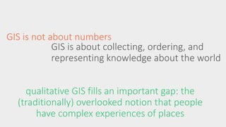
- 4. GIS is not about numbers GIS is about collecting, ordering, and representing knowledge about the world qualitative GIS fills an important gap: the (traditionally) overlooked notion that people have complex experiences of places
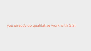
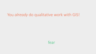
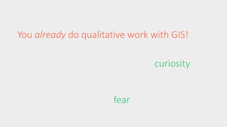
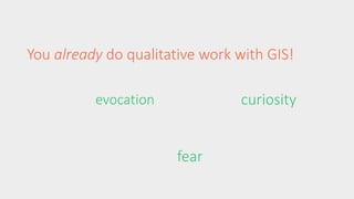
- 5. you already do qualitative work with GIS!
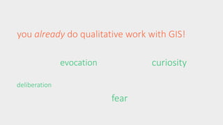
- 6. You already do qualitative work with GIS! fear
- 7. You already do qualitative work with GIS! curiosity fear
- 8. You already do qualitative work with GIS! curiosity fear evocation
- 9. you already do qualitative work with GIS! deliberation curiosity fear evocation
- 10. why look at ŌĆ£qualitativeŌĆØ data?
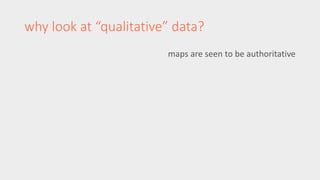
- 11. why look at ŌĆ£qualitativeŌĆØ data? maps are seen to be authoritative
- 13. maps are seen to be authoritative politically powerful! why look at ŌĆ£qualitativeŌĆØ data?
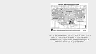
- 14. ŌĆ£theyŌĆÖre like, ŌĆśAre you sure this is it?ŌĆÖ And heŌĆÖs like, ŌĆśYes,itŌĆÖs there. ItŌĆÖs on the map.ŌĆÖ (Elwood, S. 2009. Multiple Representations, Significations, and Epistemologies in Community-Based GIS. In Qualitative GIS. )
- 15. why look at ŌĆ£qualitativeŌĆØ data? maps are seen to be authoritative politically powerful! gain insights into social processes
- 20. why look at ŌĆ£qualitativeŌĆØ data? maps are seen to be authoritative politically powerful! gain insights into social processes because geographic information is embedded with values and norms
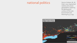
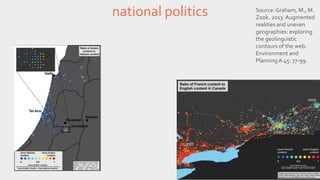
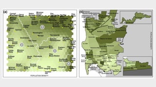
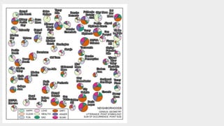
- 21. national politics Source: Graham, M., M. Zook. 2013. Augmented realities and uneven geographies: exploring the geolinguistic contours of the web. Environment and Planning A 45: 77-99.
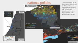
- 22. national politics Source: Graham, M., M. Zook. 2013. Augmented realities and uneven geographies: exploring the geolinguistic contours of the web. Environment and Planning A 45: 77-99.
- 23. national politics Source: Graham, M., M. Zook. 2013. Augmented realities and uneven geographies: exploring the geolinguistic contours of the web. Environment and Planning A 45: 77-99.
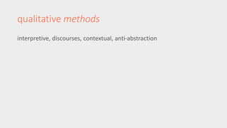
- 24. qualitative methods interpretive, discourses, contextual, anti-abstraction
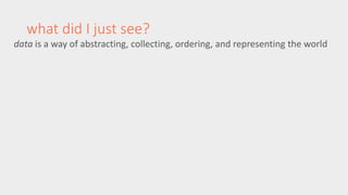
- 33. what did I just see? data is a way of abstracting, collecting, ordering, and representing the world
- 34. what did I just see? data is a way of abstracting, collecting, ordering, and representing the world qualitative data preserve the context, complexity, and richness of human experience
- 35. what did I just see? data is a way of abstracting, collecting, ordering, and representing the world qualitative data preserve the context, complexity, and richness of human experience (this does not mean itŌĆÖs inaccurate)
- 36. what did I just see? data is a way of abstracting, collecting, ordering, and representing the world qualitative data preserve the context, complexity, and richness of human experience (this does not mean itŌĆÖs inaccurate) qualitative methods can be a way of re-contextualizing numbers
- 37. thank you for your time and attention now go eat responsibly ryan burns rlburns@uw.edu http://burnsr77.github.i o
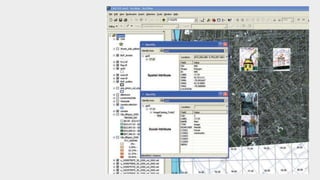
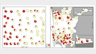
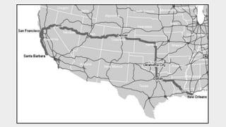
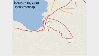
- 38. JANUARY 10, 2010 OpenStreetMap
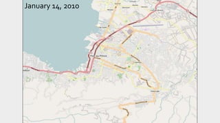
- 39. January 14, 2010
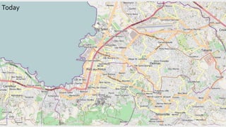
- 40. Today
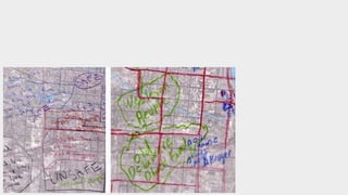
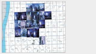
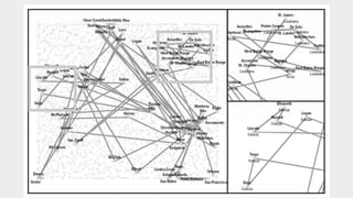
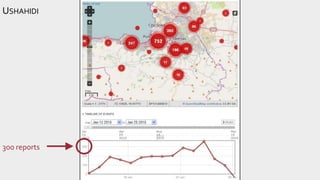
- 42. USHAHIDI [PT 2] 300 reports
Editor's Notes
- #22: mapping technologies can also serve as a rallying point around the nation as a site of politics
- #23: mapping technologies can also serve as a rallying point around the nation as a site of politics
- #24: mapping technologies can also serve as a rallying point around the nation as a site of politics
- #39: OSM is a digital humanitarian technology Leogane, 25 km west of PAP