Quick update on map printing for global atlas
ŌĆóDownload as PPTX, PDFŌĆó
1 likeŌĆó192 views

The document provides an overview of the current map printing capability. It demonstrates that users can edit map titles, legends and features before printing or downloading map images. The interface allows reordering and removing legend items as well as changing the legend position. Individual map layers can also be downloaded separately for further editing. The capability is mostly complete with a focus on finishing the backend web services.


Quick update on map printing for global atlas
- 1. Quick Update on Map Printing
- 2. Overview of Current Capability ŌĆó A series of slides outlining the capability as it stands currently in development is provided. ŌĆó An example is provided to demonstrate what can be done with the downloaded images
- 3. Overview of Current Capability ŌĆó This series of slides will walk you though the capability we have already developed. Most of the interface work is finished and we are now focused on completing the web services behind the capability.
- 4. Print Button in the Atlas Interface
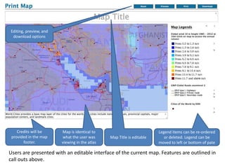
- 5. Users are presented with an editable interface of the current map. Features are outlined in call outs above. Credits will be provided in the map footer. Map is identical to what the user was viewing in the atlas Map Title is editable Legend items can be re-ordered or deleted. Legend can be moved to left or bottom of pate Editing, preview, and download options
- 7. Legend items and position changed
- 8. Legend has been removed to print just the map
- 9. The Print Preview removes editing options and shows what the map will look like when printed
- 10. Printing is accomplished with the browserŌĆÖs print dialog.
- 11. Overview of Current Capability ŌĆó The capability to download map images directly is also provided. This capability will allow users to access those directly rather than having to take screen captures of the interface and paste into PPT. ŌĆó The next few slides demonstrate what can be done with these images.
- 12. The complete map is provided as a single image
- 13. All maps are also provided independently. This slide presents all images overlaid along with their legends All maps are also provided independently. This slide presents all images overlaid along with their legends
- 14. All maps are also provided independently. This slide presents all images overlaid along with their legends Cities were removed
- 15. All maps are also provided independently. This slide presents all images overlaid along with their legends Roads were removed