狠狠撸

狠狠撸Share a Scribd company logo
RNK GEO INFRAPROJECTS LLP
GIS Brochure
1221, Maple Trade Center, Near Surdhara Circle,
SAL Hospital Road, Thaltej, Ahmedabad, 380059
(M) +91 9898981713
(O) +91 7948981713
office@rnkgeo.com
www.rnkgeo.com
? Geospatial technology is about using a range of modern tools used
for geographic mapping and analysis of the earth & human societies.
We keep Information & Technology at the core of all our offerings
? We are proficient in provision of geo-spatial solutions serving a host
of sectors ranging from infrastructure like roads and railways, utilities
like water supply, gas, electricity, mining & minerals, agriculture,
irrigation etc. Our core competency lies in providing solutions across
the entire geo-spatial domain – from data creation, conversion,
analysis, modelling and management
About us
Mission
? Provide state-of-the-art mapping in various domains, visualization of
geographic data, analysis of spatial relationships and efficient data
management
? Sustainable and Profitable growth through superior customer service
and become the preferred destination to harness the potential of
Geospatial realm around the world
Vision
? Crux in maintaining the expertise in technical skills and give original
geospatial technology solutions
? Provision of productive response, support and knowledgeable services
to cater communities need for geospatial issues and other GIS based
applications
Clients and Associates
? Poseidon Hydro Infratech
? Vector Consultancy Services
? Ambaji Infratech
? Real Lifespace LLP
Services provided
? Cadastral mapping
? Utility mapping
? Topographical mapping
? Parcel mapping
? Land Use / Land Cover Mapping
? Flood Mapping
? Geological Mapping
? Data capture
? Data creation
? Data modelling
? Data scraping
? Data cleaning
? Data conversion
? Geodatabase development
? Efficiency in Door Step Collection
? Monitoring vehicle movement
? Cautious Weight Management
? Smart Storage Bins
? Transparency in Payment
? Central Control
? Property Tax Assessment
? Survey of the individual properties
? Updation of the non-spatial database
? Infrastructure database creation
? Updation of property records
? Base maps digitization
? Land records computerization
GIS and Remote Sensing Services
Database Services
GIS based Solid waste management
Municipal GIS
Engineering Surveys
Application Development
Services provided
? Water treatment, Storm and Sanitary utilities
? Gas and electric utilities
? Street and highway maintenance, rehabilitation
or replacement
? Building, equipment and facility maintenance
? Customer service and work order management
? Earth Imaging Services
? Triangulation
? Stereo Data Collection – Feature Mapping
? Terrain Modeling and 3D Visualisation
? Orthophoto Generation
? Cartography – Map Finishing and Publishing
? Thematic Mapping using Satellite Imagery
? DEM / DTM Generation
? Topographic and Planimetric Feature Extraction
? Mosaicking And Tile Generation
? Contour Generation
? Customised Web Application Development
? WebGIS based Application development
? Customized mobile application development for
Windows/Android/Apple devices
? Mobile based Map Service Applications
? Cloud based modular GIS Applications
? Customized GIS application development/
deployment in cloud environment
? Total station survey
? Lidar Survey
? GPR Survey
? DGPS Survey
? Drone Survey
GIS based asset management
Digital Photogrammetry Services
Industry specific solutions
? Environment Impact
? Geo-referencing maps
? Land Cover Mapping
? Route Planning
? Monitoring and Change detection
? Land record management
? Land suitability analysis
? Geodetic surveys
? Geo database generation
? Land use and Land cover mapping
? Smart city planning
? Land and Property assessment
? Urban sprawl analysis and management
? Mine site planning and access to utilities
? Broad area lithological distribution mapping
? GIS based Mines and mineral management system
? Mineral excavation detection
? Monitoring mineral movement
? Assessment and Monitoring
? Risk and Geohazard assessment
? Landcover classification
? Stability monitoring
? Geographic Environmental Management System
? Pollution and forest mapping
? Wetlands management
? Network Planning
? Asset management
? Operations and performance monitoring
? Safety and security monitoring
Infrastructure
Land information management
Mining and minerals
Environment
Transportation
Industry specific solutions
? Vegetation cover and monitoring
? Digital elevation model for efficient drainage
? Planning, Analysis, Modelling of agricultural pattern
? Water requirement for irrigation and planning
? Satellite image processing for yield estimation
? Agricultural information management system
? Crop assessment and Crop health
? Irrigated landscape mapping
? Change detection studies
? Existing and future land use planning
? Urban change detection and mapping
? Urban sprawl/urban spatial growth monitoring
? Urban infrastructure and utility mapping
? Urban hydrology
? Effective traffic management
? Solid and hazardous waste management
? Field operations using high resolution imagery
? Oil and gas pipeline planning
? Environmental management
? Disaster management
? Gas distribution management system
? Data acquisition and monitoring
? Pipeline integrity management system
? Pipeline network survey and mapping
? Integrated port management system
? Port survey, planning and 3D modeling
? Fuel inventory management system
? Traffic management and tracking system
? Terminal operation system
Agriculture
Urban planning and development
Oil and Gas
Marine and port
Major Completed Works
Government of Rajasthan (GoR) initiated a
mega project for development of urban
centers of the State in the year 2000 under
ADB financing through Rajasthan Urban
Infrastructure Development Project
(RUIDP) established specially for this
purpose. Under RUIDP Phase-I of the
Program 6 (six) divisional headquarter
cities aiming for a population benefit of 77
Lacs by year 2011, viz., Ajmer, Bikaner,
Jaipur, Jodhpur, Kota and Udaipur were
taken up for development of urban
infrastructure
RNK’s scope of work was to create GIS compatible consumer survey data by
integrating total station survey with household survey and deliver based on
the requirements of the client for Kota city. The project also included
development of Geodatabase containing hydraulic design of Kota sewerage
network
Name of the work – Preparation of GIS compatible consumer survey data
(around 70000 consumers) and Hydraulic Design for Kota city under
Rajasthan Urban Sector Development Project for the construction of Kota
sewerage network.
Name of the work – Development and maintenance of Web-GIS based asset
management system
The term “Asset Management
System” (AMS) embraces all the
processes, tools, data and policies
necessary to achieve the goal of
effectively managing assets. AMS
provides an integrated approach
to all administration costs, be
they road user, works,
administration, environment or
social costs, and the use of
existing administration data
sources.
The project included development and maintenance of Web-GIS based asset
management system of Saurashtra Branch Canal. It included integration of
data from various fields such as Soil reports, Design sections, Specifications
of all the structures present on the canal, etc.
Major Completed Works
Gujarat has the total geographical area of
196 lakh ha out of which cultivable area is
124 lakh ha. Agriculture is highly
dependent upon erratic and uneven
monsoon and is basically rainfed in nature.
In Gujarat, the importance of scarce water
resources and the need for their rational
development and utilization are both self-
evident.
Government of Gujarat has various on-
going construction of minor irrigation
schemes all over Gujarat. This project was
done as a proposal to monitor the
construction and progress of various
components of the schemes in real time. It
included development and maintenance of
Management Information System based
asset management system.
Name of the work – Development and maintenance of MIS based asset
management system of minor irrigation schemes of Gujarat for monitoring
the construction and progress of the schemes in real time
Name of the work – Development and maintenance of Web-GIS based asset
management system of Underground Pipe Line (UGPL) for monitoring the
progress
Once established, asset management
systems provide a framework to
efficiently and equitably allocate scarce
resources among competing objectives.
Field personnel can take detailed GIS
information with them on any number of
mobile devices and quickly locate
relevant facilities and perform detailed
inspections.
The project was to develop and maintain Web-GIS based asset
management system of Underground Pipe Line (UGPL) for monitoring the
progress of Vansva Disty (LD - 6) of Narshingpura Branch Canal. It included
integration of data of various minor irrigation canals and integration of
various types of data into the system.
Major Completed Works
This study has successfully implemented
the functionalities for geo-visualization and
analysis of the disaster events on a web
browser in 3D-GIS environment. This was
done by integrating cesium with a
hydrological model (HAND) using WebGL
library. The hydrological model generates a
spatial layer as KML/KMZ file in real-time
based on the amount of flood mentioned by
the user.
Another objective of this study was to integrate the mobile application for
the public participatory approach of this study. This application reduces the
challenges faced during data collection. Various data sources have used in
this mobile application for weather forecasting. The data received from the
mobile application has been integrated with the cesium environment and
therefore the data can be visualized in 3D-GIS environment for effective
analysis.
Name of the work - Online 3D visualisation and virtual reality of disaster
affected areas in hilly region. The project was based on Web-GIS and aimed
to provide a web based interface that can be used for visualising potential
disaster zones of Uttarakhand. (Academic)
Name of the work - Preparation of GIS compatible data and carry out
volumetric analysis for the work “Consultancy Services for Design, Survey,
Detailed Project Report Preparation, Tender Document Preparation and
Supervision for Construction of Composite Earthen Tailing- Dam at
Jhamarkotra Mines near Udaipur”
The project was to create Digital Elevation Model and corresponding
contour maps based on total station survey and the same was further
used for the volumetric analysis to help in the design of Earthen Tailing
Dam
The major activity of RSMML is
the mining of Rockphosphate ore.
It operates one of the largest and
fully mechanized mines in the
country at Jhamarkotra, 26 Kms.
from Udaipur and Kanpur Group
of Mines located 15 Kms. from
Udaipur
Various other projects
? Providing complete GIS based analysis support and development of
Geodatabase for the work “Restoration & strengthening of Saurashtra
Branch Canals and preparation of estimates & DTP for the remedial
measures work of SBC off taking from Narmada Main Canal
(Approximate length 104 km.)”
? Providing GIS consulting services for “Preparation of Preliminary Project
Report (PPR) for carrying water from Sone river near Chataniaghat
through pipe for meeting the requirement of drinking water and
providing irrigation facilities in the area of Palamu/Garhwa district”
? Total station survey and preparation of demographic maps for layout
planning and building planning of of R.S.No. 258 and 259, Anjar Taluka
? Total station survey and utility mapping of the study area for submission
of Hotel and building plans of R.S.No. 258 of Anjar to Anjar Area
Development Authority (AADA)
? Topography, contour survey and submission of data in GIS ready format
for planning and development of S.No. 555/1, Varsamedi, Taluka Anjar.
Major Completed Works
Name of the work - A novel approach using open system architecture to
convert Indian meteorological grid data in GIS ready format - Designed and
developed a desktop application to convert Indian meteorological grid data
into GIS ready format using Python programming (Academic)
The data provided by India
Meteorological Department (IMD) is in
grid (.grd) format. This format cannot
be studied directly. Grid (.grd) format
first needs to be converted into
different format for analysing its
values. The grid file consists of values
of temperature or rainfall of the
corresponding location.
Therefore, this project was done to develop a tool or software that converts
grid file into GIS format. This tool would take grid file as input and would
provide shapefile (.shp) file as output which can be viewed directly in the
GIS softwares such as ArcGIS or QGIS.
1221, Maple Trade Center, Near Surdhara Circle,
SAL Hospital Road, Thaltej, Ahmedabad, 380059
(M) +91 9898981713
(O) +91 7948981713
office@rnkgeo.com
www.rnkgeo.com
Get in Touch With Us
Ad

Recommended

PDF
GIS enabled eGovernance
Esri India
?
PDF
Enea Enabling Real-Time in Linux Whitepaper
Enea Software AB
?
PPTX
Vehicle Tracking System
Vikas Agarwal
?
PPTX
Thesis Defense
Wendell Rodrigues
?
PDF
Erdas image analysis for arcgis
César Martín Suárez Suárez
?
PDF
Cartography and Geospatial Intelligence (GEOINT): Actionable Knowledge for Hu...
British Cartographic Society
?
PDF
Zero Gravity Communications : Corporate Profile
Khushboo Solanki Sharma
?
PDF
Anatomy of self driving vehicle
Suyash Shetty
?
PPTX
GIS at Sain Associates
SainAssociates
?
PDF
Introduction to Nespak_2016
Atiqa khan
?
PDF
A Review of _Urban Water Networks Management Using GIS
IRJET Journal
?
PPTX
Gis in urban
Dilhan Bandara
?
DOCX
murali_cv_updated
murali krishna
?
PDF
TechM GIS Utilities
TechM-GIS
?
PDF
Spatial Earth Profile2
Vishwas Nirgude
?
PDF
DIGITIZATION OF CITIES ON GIS PLATFORM.pdf
HimanshuDeshmukh32
?
PPTX
Introduction to gis and its application
gandhinagar
?
PPTX
Applications of gis
PRAMODA G
?
PPTX
Applications of gis
PRAMODA G
?
PPTX
GIS-WaterSector (1).pptx
sayedkhaderahmed
?
DOC
Gis
whitetpgit
?
PDF
Geographic information systems
Mukund Harne
?
PDF
Thames Tunnel: the Many Forms of Web GIS Reporting
Esri
?
PPTX
Gis powerpoint
kaushdave
?
PPTX
ADCC Infocad Limited
Ceinsys Tech Limited
?
PDF
Vivek Resume
Vivekananth Arunachalam
?
PPTX
Application of GIS (Geographical information system)
Fayaz Ahamed A P
?
PPTX
Using GIS for Water Resources Management – Selected U.S. and International Ap...
Michael Baker Jr., Inc.
?
PDF
Measurecamp Copenhagen - Consent Context
Human37
?
PPTX
定制翱颁础顿学生卡加拿大安大略艺术与设计大学成绩单范本,翱颁础顿成绩单复刻
taqyed
?

More Related Content

Similar to RNK - GIS Brochure (20)

PPTX
GIS at Sain Associates
SainAssociates
?
PDF
Introduction to Nespak_2016
Atiqa khan
?
PDF
A Review of _Urban Water Networks Management Using GIS
IRJET Journal
?
PPTX
Gis in urban
Dilhan Bandara
?
DOCX
murali_cv_updated
murali krishna
?
PDF
TechM GIS Utilities
TechM-GIS
?
PDF
Spatial Earth Profile2
Vishwas Nirgude
?
PDF
DIGITIZATION OF CITIES ON GIS PLATFORM.pdf
HimanshuDeshmukh32
?
PPTX
Introduction to gis and its application
gandhinagar
?
PPTX
Applications of gis
PRAMODA G
?
PPTX
Applications of gis
PRAMODA G
?
PPTX
GIS-WaterSector (1).pptx
sayedkhaderahmed
?
DOC
Gis
whitetpgit
?
PDF
Geographic information systems
Mukund Harne
?
PDF
Thames Tunnel: the Many Forms of Web GIS Reporting
Esri
?
PPTX
Gis powerpoint
kaushdave
?
PPTX
ADCC Infocad Limited
Ceinsys Tech Limited
?
PDF
Vivek Resume
Vivekananth Arunachalam
?
PPTX
Application of GIS (Geographical information system)
Fayaz Ahamed A P
?
PPTX
Using GIS for Water Resources Management – Selected U.S. and International Ap...
Michael Baker Jr., Inc.
?
GIS at Sain Associates
SainAssociates
?
Introduction to Nespak_2016
Atiqa khan
?
A Review of _Urban Water Networks Management Using GIS
IRJET Journal
?
Gis in urban
Dilhan Bandara
?
murali_cv_updated
murali krishna
?
TechM GIS Utilities
TechM-GIS
?
Spatial Earth Profile2
Vishwas Nirgude
?
DIGITIZATION OF CITIES ON GIS PLATFORM.pdf
HimanshuDeshmukh32
?
Introduction to gis and its application
gandhinagar
?
Applications of gis
PRAMODA G
?
Applications of gis
PRAMODA G
?
GIS-WaterSector (1).pptx
sayedkhaderahmed
?
Geographic information systems
Mukund Harne
?
Thames Tunnel: the Many Forms of Web GIS Reporting
Esri
?
Gis powerpoint
kaushdave
?
ADCC Infocad Limited
Ceinsys Tech Limited
?
Application of GIS (Geographical information system)
Fayaz Ahamed A P
?
Using GIS for Water Resources Management – Selected U.S. and International Ap...
Michael Baker Jr., Inc.
?

Recently uploaded (20)

PDF
Measurecamp Copenhagen - Consent Context
Human37
?
PPTX
定制翱颁础顿学生卡加拿大安大略艺术与设计大学成绩单范本,翱颁础顿成绩单复刻
taqyed
?
PPTX
最新版美国佐治亚大学毕业证(鲍骋础毕业证书)原版定制
Taqyea
?
PPTX
ppt somu_Jarvis_AI_Assistant_presen.pptx
MohammedumarFarhan
?
PPTX
最新版美国威斯康星大学河城分校毕业证(鲍奥搁贵毕业证书)原版定制
taqyea
?
PPTX
美国毕业证范本中华盛顿大学学位证书颁奥鲍学生卡购买
Taqyea
?
PPTX
Daily, Weekly, Monthly Report MTC March 2025.pptx
PanjiDewaPamungkas1
?
PDF
624753984-Annex-A3-RPMS-Tool-for-Proficient-Teachers-SY-2024-2025.pdf
CristineGraceAcuyan
?
PDF
Allotted-MBBS-Student-list-batch-2021.pdf
subhansaifi0603
?
PDF
Residential Zone 4 for industrial village
MdYasinArafat13
?
PDF
Informatics Market Insights AI Workforce.pdf
karizaroxx
?
PPTX
最新版美国约翰霍普金斯大学毕业证(闯贬鲍毕业证书)原版定制
Taqyea
?
PPTX
一比一原版(罢鲍颁毕业证书)开姆尼茨工业大学毕业证如何办理
taqyed
?
PPTX
Crafting-Research-Recommendations Grade 12.pptx
DaryllWhere
?
PPSX
PPT1_CB_VII_CS_Ch3_FunctionsandChartsinCalc.ppsx
animaroy81
?
PDF
NVIDIA Triton Inference Server, a game-changing platform for deploying AI mod...
Tamanna36
?
PPTX
UPS and Big Data intro to Business Analytics.pptx
sanjum5582
?
PPTX
PPT2 W1L2.pptx.........................................
palicteronalyn26
?
PDF
ilide.info-tg-understanding-culture-society-and-politics-pr_127f984d2904c57ec...
jed P
?
PPTX
@Reset-Password.pptx presentakh;kenvtion
MarkLariosa1
?
Measurecamp Copenhagen - Consent Context
Human37
?
定制翱颁础顿学生卡加拿大安大略艺术与设计大学成绩单范本,翱颁础顿成绩单复刻
taqyed
?
最新版美国佐治亚大学毕业证(鲍骋础毕业证书)原版定制
Taqyea
?
ppt somu_Jarvis_AI_Assistant_presen.pptx
MohammedumarFarhan
?
最新版美国威斯康星大学河城分校毕业证(鲍奥搁贵毕业证书)原版定制
taqyea
?
美国毕业证范本中华盛顿大学学位证书颁奥鲍学生卡购买
Taqyea
?
Daily, Weekly, Monthly Report MTC March 2025.pptx
PanjiDewaPamungkas1
?
624753984-Annex-A3-RPMS-Tool-for-Proficient-Teachers-SY-2024-2025.pdf
CristineGraceAcuyan
?
Allotted-MBBS-Student-list-batch-2021.pdf
subhansaifi0603
?
Residential Zone 4 for industrial village
MdYasinArafat13
?
Informatics Market Insights AI Workforce.pdf
karizaroxx
?
最新版美国约翰霍普金斯大学毕业证(闯贬鲍毕业证书)原版定制
Taqyea
?
一比一原版(罢鲍颁毕业证书)开姆尼茨工业大学毕业证如何办理
taqyed
?
Crafting-Research-Recommendations Grade 12.pptx
DaryllWhere
?
PPT1_CB_VII_CS_Ch3_FunctionsandChartsinCalc.ppsx
animaroy81
?
NVIDIA Triton Inference Server, a game-changing platform for deploying AI mod...
Tamanna36
?
UPS and Big Data intro to Business Analytics.pptx
sanjum5582
?
PPT2 W1L2.pptx.........................................
palicteronalyn26
?
ilide.info-tg-understanding-culture-society-and-politics-pr_127f984d2904c57ec...
jed P
?
@Reset-Password.pptx presentakh;kenvtion
MarkLariosa1
?
Ad

RNK - GIS Brochure

  • 1. RNK GEO INFRAPROJECTS LLP GIS Brochure 1221, Maple Trade Center, Near Surdhara Circle, SAL Hospital Road, Thaltej, Ahmedabad, 380059 (M) +91 9898981713 (O) +91 7948981713 office@rnkgeo.com www.rnkgeo.com
  • 2. ? Geospatial technology is about using a range of modern tools used for geographic mapping and analysis of the earth & human societies. We keep Information & Technology at the core of all our offerings ? We are proficient in provision of geo-spatial solutions serving a host of sectors ranging from infrastructure like roads and railways, utilities like water supply, gas, electricity, mining & minerals, agriculture, irrigation etc. Our core competency lies in providing solutions across the entire geo-spatial domain – from data creation, conversion, analysis, modelling and management About us Mission ? Provide state-of-the-art mapping in various domains, visualization of geographic data, analysis of spatial relationships and efficient data management ? Sustainable and Profitable growth through superior customer service and become the preferred destination to harness the potential of Geospatial realm around the world Vision ? Crux in maintaining the expertise in technical skills and give original geospatial technology solutions ? Provision of productive response, support and knowledgeable services to cater communities need for geospatial issues and other GIS based applications Clients and Associates ? Poseidon Hydro Infratech ? Vector Consultancy Services ? Ambaji Infratech ? Real Lifespace LLP
  • 3. Services provided ? Cadastral mapping ? Utility mapping ? Topographical mapping ? Parcel mapping ? Land Use / Land Cover Mapping ? Flood Mapping ? Geological Mapping ? Data capture ? Data creation ? Data modelling ? Data scraping ? Data cleaning ? Data conversion ? Geodatabase development ? Efficiency in Door Step Collection ? Monitoring vehicle movement ? Cautious Weight Management ? Smart Storage Bins ? Transparency in Payment ? Central Control ? Property Tax Assessment ? Survey of the individual properties ? Updation of the non-spatial database ? Infrastructure database creation ? Updation of property records ? Base maps digitization ? Land records computerization GIS and Remote Sensing Services Database Services GIS based Solid waste management Municipal GIS
  • 4. Engineering Surveys Application Development Services provided ? Water treatment, Storm and Sanitary utilities ? Gas and electric utilities ? Street and highway maintenance, rehabilitation or replacement ? Building, equipment and facility maintenance ? Customer service and work order management ? Earth Imaging Services ? Triangulation ? Stereo Data Collection – Feature Mapping ? Terrain Modeling and 3D Visualisation ? Orthophoto Generation ? Cartography – Map Finishing and Publishing ? Thematic Mapping using Satellite Imagery ? DEM / DTM Generation ? Topographic and Planimetric Feature Extraction ? Mosaicking And Tile Generation ? Contour Generation ? Customised Web Application Development ? WebGIS based Application development ? Customized mobile application development for Windows/Android/Apple devices ? Mobile based Map Service Applications ? Cloud based modular GIS Applications ? Customized GIS application development/ deployment in cloud environment ? Total station survey ? Lidar Survey ? GPR Survey ? DGPS Survey ? Drone Survey GIS based asset management Digital Photogrammetry Services
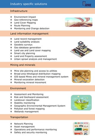
  • 5. Industry specific solutions ? Environment Impact ? Geo-referencing maps ? Land Cover Mapping ? Route Planning ? Monitoring and Change detection ? Land record management ? Land suitability analysis ? Geodetic surveys ? Geo database generation ? Land use and Land cover mapping ? Smart city planning ? Land and Property assessment ? Urban sprawl analysis and management ? Mine site planning and access to utilities ? Broad area lithological distribution mapping ? GIS based Mines and mineral management system ? Mineral excavation detection ? Monitoring mineral movement ? Assessment and Monitoring ? Risk and Geohazard assessment ? Landcover classification ? Stability monitoring ? Geographic Environmental Management System ? Pollution and forest mapping ? Wetlands management ? Network Planning ? Asset management ? Operations and performance monitoring ? Safety and security monitoring Infrastructure Land information management Mining and minerals Environment Transportation
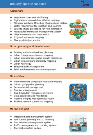
  • 6. Industry specific solutions ? Vegetation cover and monitoring ? Digital elevation model for efficient drainage ? Planning, Analysis, Modelling of agricultural pattern ? Water requirement for irrigation and planning ? Satellite image processing for yield estimation ? Agricultural information management system ? Crop assessment and Crop health ? Irrigated landscape mapping ? Change detection studies ? Existing and future land use planning ? Urban change detection and mapping ? Urban sprawl/urban spatial growth monitoring ? Urban infrastructure and utility mapping ? Urban hydrology ? Effective traffic management ? Solid and hazardous waste management ? Field operations using high resolution imagery ? Oil and gas pipeline planning ? Environmental management ? Disaster management ? Gas distribution management system ? Data acquisition and monitoring ? Pipeline integrity management system ? Pipeline network survey and mapping ? Integrated port management system ? Port survey, planning and 3D modeling ? Fuel inventory management system ? Traffic management and tracking system ? Terminal operation system Agriculture Urban planning and development Oil and Gas Marine and port
  • 7. Major Completed Works Government of Rajasthan (GoR) initiated a mega project for development of urban centers of the State in the year 2000 under ADB financing through Rajasthan Urban Infrastructure Development Project (RUIDP) established specially for this purpose. Under RUIDP Phase-I of the Program 6 (six) divisional headquarter cities aiming for a population benefit of 77 Lacs by year 2011, viz., Ajmer, Bikaner, Jaipur, Jodhpur, Kota and Udaipur were taken up for development of urban infrastructure RNK’s scope of work was to create GIS compatible consumer survey data by integrating total station survey with household survey and deliver based on the requirements of the client for Kota city. The project also included development of Geodatabase containing hydraulic design of Kota sewerage network Name of the work – Preparation of GIS compatible consumer survey data (around 70000 consumers) and Hydraulic Design for Kota city under Rajasthan Urban Sector Development Project for the construction of Kota sewerage network. Name of the work – Development and maintenance of Web-GIS based asset management system The term “Asset Management System” (AMS) embraces all the processes, tools, data and policies necessary to achieve the goal of effectively managing assets. AMS provides an integrated approach to all administration costs, be they road user, works, administration, environment or social costs, and the use of existing administration data sources. The project included development and maintenance of Web-GIS based asset management system of Saurashtra Branch Canal. It included integration of data from various fields such as Soil reports, Design sections, Specifications of all the structures present on the canal, etc.
  • 8. Major Completed Works Gujarat has the total geographical area of 196 lakh ha out of which cultivable area is 124 lakh ha. Agriculture is highly dependent upon erratic and uneven monsoon and is basically rainfed in nature. In Gujarat, the importance of scarce water resources and the need for their rational development and utilization are both self- evident. Government of Gujarat has various on- going construction of minor irrigation schemes all over Gujarat. This project was done as a proposal to monitor the construction and progress of various components of the schemes in real time. It included development and maintenance of Management Information System based asset management system. Name of the work – Development and maintenance of MIS based asset management system of minor irrigation schemes of Gujarat for monitoring the construction and progress of the schemes in real time Name of the work – Development and maintenance of Web-GIS based asset management system of Underground Pipe Line (UGPL) for monitoring the progress Once established, asset management systems provide a framework to efficiently and equitably allocate scarce resources among competing objectives. Field personnel can take detailed GIS information with them on any number of mobile devices and quickly locate relevant facilities and perform detailed inspections. The project was to develop and maintain Web-GIS based asset management system of Underground Pipe Line (UGPL) for monitoring the progress of Vansva Disty (LD - 6) of Narshingpura Branch Canal. It included integration of data of various minor irrigation canals and integration of various types of data into the system.
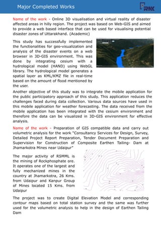
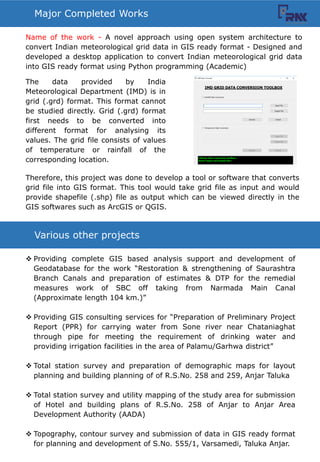
  • 9. Major Completed Works This study has successfully implemented the functionalities for geo-visualization and analysis of the disaster events on a web browser in 3D-GIS environment. This was done by integrating cesium with a hydrological model (HAND) using WebGL library. The hydrological model generates a spatial layer as KML/KMZ file in real-time based on the amount of flood mentioned by the user. Another objective of this study was to integrate the mobile application for the public participatory approach of this study. This application reduces the challenges faced during data collection. Various data sources have used in this mobile application for weather forecasting. The data received from the mobile application has been integrated with the cesium environment and therefore the data can be visualized in 3D-GIS environment for effective analysis. Name of the work - Online 3D visualisation and virtual reality of disaster affected areas in hilly region. The project was based on Web-GIS and aimed to provide a web based interface that can be used for visualising potential disaster zones of Uttarakhand. (Academic) Name of the work - Preparation of GIS compatible data and carry out volumetric analysis for the work “Consultancy Services for Design, Survey, Detailed Project Report Preparation, Tender Document Preparation and Supervision for Construction of Composite Earthen Tailing- Dam at Jhamarkotra Mines near Udaipur” The project was to create Digital Elevation Model and corresponding contour maps based on total station survey and the same was further used for the volumetric analysis to help in the design of Earthen Tailing Dam The major activity of RSMML is the mining of Rockphosphate ore. It operates one of the largest and fully mechanized mines in the country at Jhamarkotra, 26 Kms. from Udaipur and Kanpur Group of Mines located 15 Kms. from Udaipur
  • 10. Various other projects ? Providing complete GIS based analysis support and development of Geodatabase for the work “Restoration & strengthening of Saurashtra Branch Canals and preparation of estimates & DTP for the remedial measures work of SBC off taking from Narmada Main Canal (Approximate length 104 km.)” ? Providing GIS consulting services for “Preparation of Preliminary Project Report (PPR) for carrying water from Sone river near Chataniaghat through pipe for meeting the requirement of drinking water and providing irrigation facilities in the area of Palamu/Garhwa district” ? Total station survey and preparation of demographic maps for layout planning and building planning of of R.S.No. 258 and 259, Anjar Taluka ? Total station survey and utility mapping of the study area for submission of Hotel and building plans of R.S.No. 258 of Anjar to Anjar Area Development Authority (AADA) ? Topography, contour survey and submission of data in GIS ready format for planning and development of S.No. 555/1, Varsamedi, Taluka Anjar. Major Completed Works Name of the work - A novel approach using open system architecture to convert Indian meteorological grid data in GIS ready format - Designed and developed a desktop application to convert Indian meteorological grid data into GIS ready format using Python programming (Academic) The data provided by India Meteorological Department (IMD) is in grid (.grd) format. This format cannot be studied directly. Grid (.grd) format first needs to be converted into different format for analysing its values. The grid file consists of values of temperature or rainfall of the corresponding location. Therefore, this project was done to develop a tool or software that converts grid file into GIS format. This tool would take grid file as input and would provide shapefile (.shp) file as output which can be viewed directly in the GIS softwares such as ArcGIS or QGIS.
  • 11. 1221, Maple Trade Center, Near Surdhara Circle, SAL Hospital Road, Thaltej, Ahmedabad, 380059 (M) +91 9898981713 (O) +91 7948981713 office@rnkgeo.com www.rnkgeo.com Get in Touch With Us