SNPWG GeoCoastPilot
Download as ppt, pdf2 likes972 views

The document discusses the GeoCoastPilot project, which links the NOAA Coast Pilot with geo-referenced imagery, charts, and other information. It describes how key features from the Coast Pilot are tagged with XML identifiers and linked to related data like images, locations, and regulations. This creates an interactive digital version of the Coast Pilot that could integrate additional data sources over time. The initial version for Portsmouth Harbor is available online, with the next version focusing on Boston Harbor.
![Thanks for listening http://schwehr.org/ [email_address]](https://image.slidesharecdn.com/20090226-snpwg-schwehr-v09-090918112926-phpapp01/85/SNPWG-GeoCoastPilot-45-320.jpg)
SNPWG GeoCoastPilot
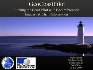
- 1. Kurt Schwehr Matthew Plumlee Briana Sullivan Colin Ware 26-Feb-2009 GeoCoastPilot Linking the Coast Pilot with Geo-referenced Imagery & Chart Information
- 2. Center for Coastal and Ocean Mapping / NOAA Joint Hydrographic Center development of hydrographic & ocean mapping technologies and approaches expand the scope of ocean mapping constituencies through the development of applications and collaborative work with both private sector and government labs educate a new generation of hydrographers and ocean mappers for the growing needs of both government agencies and private sector SNPWG http://www.ccom.unh.edu/vislab
- 3. Research Themes Sonar System Capabilities and Limitations New approaches to multibeam sonar data processing New Applications of Seafloor Mapping Data Remote Seafloor Characterization and Fisheries Habitat Data Visualization and Management Law of the Sea Chart of the Future SNPWG http://www.ccom.unh.edu/vislab
- 4. Warning! What mariners need is strongly task dependent SNPWG http://www.ccom.unh.edu/vislab
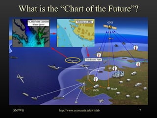
- 7. What is the ŌĆ£Chart of the FutureŌĆØ? SNPWG http://www.ccom.unh.edu/vislab
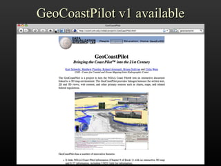
- 8. GeoCoastPilot v1 available SNPWG http://www.ccom.unh.edu/vislab
- 9. Additional Topics How do we streamline data collection/validation? Metadata and data tracking How old is data / when does it need to be updated? Integrating the Code of Federal Regulations (CFR) SNPWG http://www.ccom.unh.edu/vislab
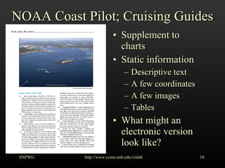
- 10. NOAA Coast Pilot; Cruising Guides Supplement to charts Static information Descriptive text A few coordinates A few images Tables What might an electronic version look like? SNPWG http://www.ccom.unh.edu/vislab
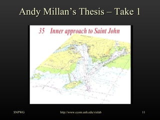
- 11. Andy MillanŌĆÖs Thesis ŌĆō Take 1 SNPWG http://www.ccom.unh.edu/vislab
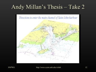
- 12. Andy MillanŌĆÖs Thesis ŌĆō Take 2 SNPWG http://www.ccom.unh.edu/vislab
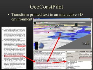
- 13. GeoCoastPilot Transform printed text to an interactive 3D environment http://www.ccom.unh.edu/vislab
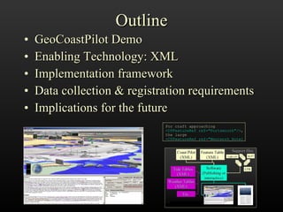
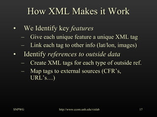
- 14. Outline GeoCoastPilot Demo Enabling Technology: XML Implementation framework Data collection & registration requirements Implications for the future For craft approaching <CPFeatureRef ref="Portsmouth"/> , the large <CPFeatureRef ref="Wentworh_Hotel
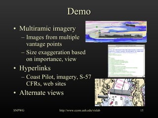
- 15. Demo Multiramic imagery Images from multiple vantage points Size exaggeration based on importance, view Hyperlinks Coast Pilot, imagery, S-57 CFRs, web sites Alternate views SNPWG http://www.ccom.unh.edu/vislab
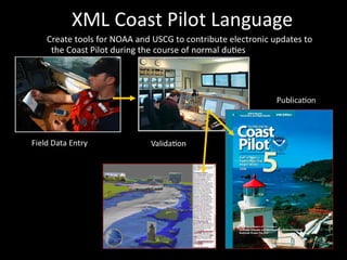
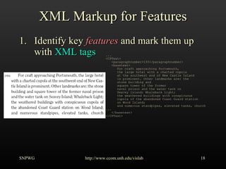
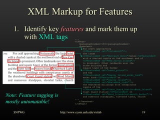
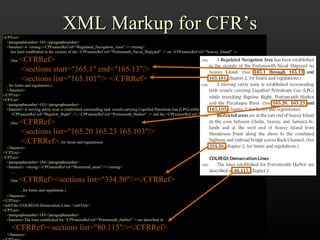
- 17. How XML Makes it Work We Identify key features Give each unique feature a unique XML tag Link each tag to other info (lat/lon, images) Identify references to outside data Create XML tags for each type of outside ref. Map tags to external sources (CFRŌĆÖs, URLŌĆÖsŌĆ”) SNPWG http://www.ccom.unh.edu/vislab
- 18. XML Markup for Features Identify key features and mark them up with XML tags SNPWG http://www.ccom.unh.edu/vislab ... <CPText> <paragraphnumber>193</paragraphnumber> <basetext> For craft approaching Portsmouth, the large hotel with a charted cupola at the southwest end of New Castle Island is prominent. Other landmarks are: the stone building and square tower of the former naval prison and the water tank on Seavey Island; Whaleback Light; the weathered buildings with conspicuous cupola of the abandoned Coast Guard station on Wood Island; and numerous standpipes, elevated tanks, church ... </basetext> </CPText>
- 19. XML Markup for Features Identify key features and mark them up with XML tags SNPWG http://www.ccom.unh.edu/vislab ... <CPText> <paragraphnumber>193</paragraphnumber> <basetext> For craft approaching <CPFeatureRef ref="Portsmouth"/>, the large <CPFeatureRef ref="Wentworh_Hotel"> hotel </CPFeatureRef> with a charted cupola at the southwest end of <CPFeatureRef ref="New_Castle_Island"/> is prominent. Other landmarks are: the stone building and square tower of the former <CPFeatureRef ref="naval_prison"/> and the <CPFeatureRef ref="Seavey_Island_water_tank"> water tank </CPFeatureRef> on <CPFeatureRef ref="Seavey_Island"/> ; <CPFeatureRef ref="Whaleback_Light"/> ; the weathered buildings with conspicuous cupola of the <CPFeatureRef ref="Coast_Guard_Station:Wood_Island"> Coast Guard station </CPFeatureRef> on <CPFeatureRef ref="Wood_Island:Portsmouth_Harbor"/> ; and numerous standpipes, elevated tanks, church ... </basetext> </CPText> Note: Feature tagging is mostly automatable!
- 20. XML Markup for Features Identify key features and mark them up with XML tags Create table: XML tags ’ā© feature records Make feature records point to sources of info (images, URLŌĆÖs, ŌĆ”) SNPWG http://www.ccom.unh.edu/vislab Tag Reference Geo. Coordinate Record name ŌĆ” Coast_Guard_Station:WoodIsland Wood_Island naval_prison Naval_Prison Portsmouth Seavey_Island Seavey_Island_water_tank Wentworth_Hotel Wentworth Whaleback_Light (43┬░03.5'N., 70┬░41.8'W.) Whaleback_Lighthouse Wood_Island:Portsmouth_Harbor Wood_Island
- 21. XML Markup for CFRŌĆÖs <CPText> <paragraphnumber>182</paragraphnumber> <basetext>A <strong><CPFeatureRef ref="Regulated_Navigation_Area" /></strong> has been established in the vicinity of the <CPFeatureRef ref="Portsmouth_Naval_Shipyard" /> on <CPFeatureRef ref="Seavey_Island" />. (See <CFRRef> <sections start="165.1" end="165.13"/> <sections list="165.101"/> </CFRRef> , for limits and regulations.) </basetext> </CPText> <CPText> <paragraphnumber>183</paragraphnumber> <basetext>A moving safety zone is established surrounding tank vessels carrying Liquified Petroleum Gas (LPG) while transiting <CPFeatureRef ref="Bigelow_Bight" />, <CPFeatureRef ref="Portsmouth_Harbor" /> and the <CPFeatureRef ref="Piscataqua_River" />. (See <CFRRef> <sections list="165.20 165.23 165.103"/> </CFRRef> , for limits and regulations) </basetext> </CPText> <CPText> <paragraphnumber>184</paragraphnumber> <basetext> <strong><CPFeatureRef ref="Restricted_areas" /></strong> ŌĆ” (See <CFRRef><sections list="334.50"/></CFRRef> , for limits and regulations.) </basetext> </CPText> <subTitle>COLREGS Demarcation Lines </subTitle> <CPText> <paragraphnumber>185</paragraphnumber> <basetext>The lines established for <CPFeatureRef ref="Portsmouth_Harbor" /> are described in <CFRRef><sections list="80.115"/></CFRRef> . </basetext> </CPText>
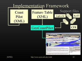
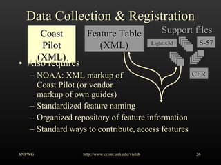
- 22. Implementation Framework SNPWG http://www.ccom.unh.edu/vislab Coast Pilot (XML) Feature Table (XML) Support files GeoCoastPilot S-57 CFR Light.x3d
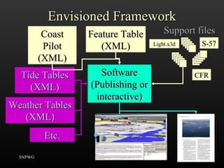
- 23. Envisioned Framework SNPWG Coast Pilot (XML) Feature Table (XML) Support files Software (Publishing or interactive) S-57 CFR Light.x3d Tide Tables (XML) Weather Tables (XML) Etc.
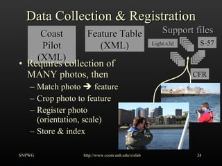
- 24. Data Collection & Registration Requires collection of MANY photos, then Match photo ’ā© feature Crop photo to feature Register photo (orientation, scale) Store & index SNPWG http://www.ccom.unh.edu/vislab Coast Pilot (XML) Feature Table (XML) Support files S-57 CFR Light.x3d
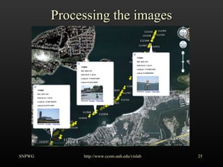
- 25. Processing the images SNPWG http://www.ccom.unh.edu/vislab
- 26. Data Collection & Registration Also requires NOAA: XML markup of Coast Pilot (or vendor markup of own guides) Standardized feature naming Organized repository of feature information Standard ways to contribute, access features SNPWG http://www.ccom.unh.edu/vislab Coast Pilot (XML) Support files Feature Table (XML) S-57 CFR Light.x3d
- 27. ╠²
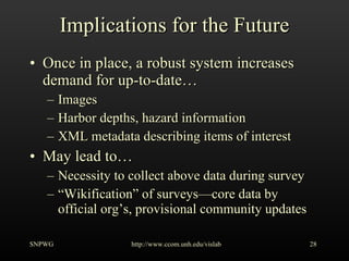
- 28. Implications for the Future Once in place, a robust system increases demand for up-to-dateŌĆ” Images Harbor depths, hazard information XML metadata describing items of interest May lead toŌĆ” Necessity to collect above data during survey ŌĆ£ WikificationŌĆØ of surveysŌĆöcore data by official orgŌĆÖs, provisional community updates SNPWG http://www.ccom.unh.edu/vislab
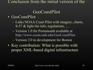
- 29. Conclusion from the initial version of the GeoCoastPilot GeoCoastPilot Links NOAA Coast Pilot with imagery, charts, S-57 & light-list info, regulations, ŌĆ” Version 1.0 for Portsmouth available at http://www.ccom.unh.edu/GeoCoastPilot Version 2.0 in development for Boston Key contribution: What is possible with proper XML-based digital infrastructure SNPWG http://www.ccom.unh.edu/vislab
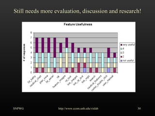
- 30. Still needs more evaluation, discussion and research! SNPWG http://www.ccom.unh.edu/vislab
- 31. Other data products that may be able to support Nautical Publications Automatic Identification System (AIS) Incident Databases (e.g. USCG MISLE) New Tides and Currents tools SNPWG http://www.ccom.unh.edu/vislab
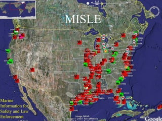
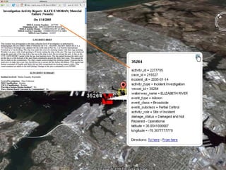
- 32. MISLE Marine Information for Safety and Law Enforcement
- 33. MISLE linked to USCG Investigation Report
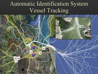
- 34. Automatic Identification System Vessel Tracking SNPWG http://www.ccom.unh.edu/vislab
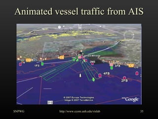
- 35. Animated vessel traffic from AIS SNPWG http://www.ccom.unh.edu/vislab
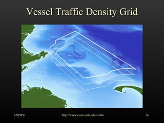
- 36. Vessel Traffic Density Grid SNPWG http://www.ccom.unh.edu/vislab
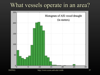
- 37. What vessels operate in an area? SNPWG http://www.ccom.unh.edu/vislab Histogram of AIS vessel draught (in meters)
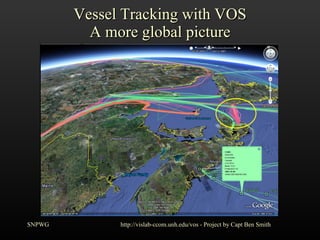
- 38. Vessel Tracking with VOS A more global picture SNPWG http://vislab-ccom.unh.edu/vos - Project by Capt Ben Smith
- 39. nowCOAST
- 40. ╠²
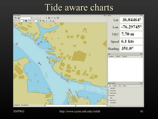
- 41. Tide aware charts SNPWG http://www.ccom.unh.edu/vislab
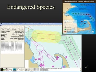
- 42. Endangered Species SNPWG http://www.ccom.unh.edu/vislab
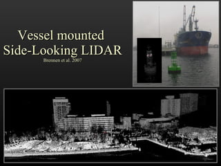
- 43. Vessel mounted Side-Looking LIDAR Brennen et al. 2007
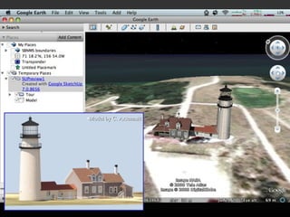
- 44. Model by C. Arsenault
- 45. Thanks for listening http://schwehr.org/ [email_address]
- 46. Additional information My blog: http://schwehr.org/blog Google Tech talk by Kurt: http://www.youtube.com/watch?v=Szw2mkqicos More Chart of the Future related videos: http://www.youtube.com/goatbar A 2004 Chart of the Future Paper: http://www.trb.org/conferences/mts/2a%20plumlee.pdf SNPWG http://www.ccom.unh.edu/vislab
Editor's Notes
- #2: Roland Arsenault provided critical support for the GeoZui4D / libgz infrastructure used by GeoCoastPilot version 1. GeoZui is a 3D graphical programming environment that also supports time. GeoZui was developed by the Data Visualization Research Lab of CCOM/JHC at the University of New Hampshire. http://vislab-ccom.unh.edu/GeoZui4D/
- #3: A brief introduction to CCOM/JHC for people not familiar with the organization. The group started in 1999/2000 and is located near the coast in Durham, NH. UNH has marine facilities at Jackson Estuarine Labs in Little Bay and Newcastle, NH.
- #4: For more detailed information on the ongoing research at CCOM/JHC, please see our annual progress reports at http://ccom.unh.edu/index.php?p=2|50|85&page=about_us/annual_reports.php For example, the 2007 report: http://ccom.unh.edu/about_us/reports/2007_ccom_progressReport.pdf Kurt Schwehr heads up the Chart of the Future (CotF) theme. This theme looks at a wide range of research tasks to improve information handling in the maritime environment. This ranges from what information mariners use while at sea to what they have available while planning prior to work on the water. However, the research does not stop there. It includes tools for shore side monitoring of vessel activities and long term planning for those managing the support infrastructures that allow waterways to function smoothly. We work with NOAA, USCG, NASA, state & local agencies, and mariners of all types to create a broad range of possible solutions. With our industrial partners (e.g. Caris and ICAN Marine), we work to bring the research from the technology demonstration phase to deployment and use in maritime operations.
- #5: The information needed by mariners is strongly influenced by the task that they are currently engaged in, the environmental conditions, their knowledge of the area, the intricacies of the local environment, the instruments available, and number of crew on board. What works for one mariner may not work for others. For example, dredgers, pilots, and fisherman all have different needs. Additionally, it is likely that the most common navigational aids across all vessels types (ranging from kayaks to large tankers) are now the personal cell phone and GPS units.
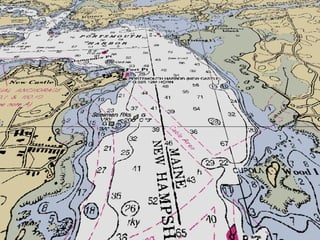
- #6: CCOM/JHC aims to take traditional products that work well and integrate them with more modern techniques. Here we have the Raster Nautical Chart (RNC/BSB) from NOAA showing the entrance to Portsmouth Harbor, NH.
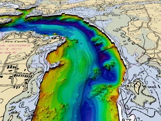
- #7: For example, some maritime tasks may be better suited to a blended chart and multibeam shaded relief model of bathymetry. Other tasks might decimate the chart to just a safe water contour, the shoreline, and the key buoys.
- #8: At CCOM/JHC, we view the Chart of the Future as a blend of technologies, both old and new, that bring the right information to the mariner for the task at hand. For example, vessels attempting to bring in the maximum cargo with small under-keel clearances will benefit from nowcast and forecast water level displays. The system provides realtime AIS water level messages to TCARI for onboard finite element based safe-water contour determination by comparison to a high resolution multibeam bathymetry.
- #9: Please download and try the demonstration software: GeoCoastPilot. Version 1 of the GeoCoastPilot illustrates what might be done with future versions of Coast Pilot / Sailing Directions style nautical publications. The demonstration covers Portsmouth, NH. The site was chosen based on the proximity to our research facilities.
- #10: While going through the following slides, keep these topics in mind. Future nautical publications may require much more data to be collected in the field, but with proper automation, it may be possible for the workload to actually be less that what it currently takes to maintain the documents and keep them current.
- #11: This is view of a current sailing directions nautical publication. It exists in both physical print form and as a digital PDF. Up till now, these publications were limited to what can be presented in a paper form. It had to be a one size fits all document. We want to preserve the quality of the existing publication and at the same time, allow these documents to provide additional capabilities, information, and display types if the vessel has a computer or other flexible display device available.
- #12: One concept explored by Andres Millan while he was working on his Masters at Univ. of New Brunswick is the idea of providing videos with a narrator explaining what the mariner is seeing. Additionally, the video is overlaid with markings to highlight key features. In this movie, the video focuses on the view from an aircraft. http://www.omg.unb.ca/omg/papers/Millan_Andres_USHydro07.pdf http://gge.unb.ca./Pubs/TR254.pdf http://gge.unb.ca./Pubs/TR254InnerApproachToSaintJohn.swf
- #13: This second video by Andres Millan focuses on the view from the water and the features as they might look when viewed from a vessel. Especially interesting is to see directional arrows on top of the water and at one point the video blends into 3D bathymetry to show the rocks inside of a buoy that should be avoided. This is a dramatic emphasis on following the routing on the chart. For more information, please see his paper from the US Hydro 2007 conference or his Masters Thesis entitled Sailing Directions in Digital Format: An Opportunity for Enriched Media and Information Content . http://www.omg.unb.ca/omg/papers/Millan_Andres_USHydro07.pdf http://gge.unb.ca./Pubs/TR254.pdf http://gge.unb.ca./Pubs/TR254TheChannelIntoTheHarbour.swf
- #14: CCOM and the VisLab have created the GeoCoastPilot to demonstrate and test a number of concepts. The key focus has been to increase the amount of georeferencing that goes along with any feature or area in the nautical publication. Think of this as geospatial hyperlinks as you might find on an internet web page. Anything in the text that is a place should be a clickable link to the location in a view of the world or chart. Anything in the chart that has a reference in the text should be linkable back to the text. Additionally, any feature or location that has additional information in other charts or tables, should be able to have that information brought into the interface when that feature is selected by the operator (e.g. light lists and S57 object information). We believe that there are many different ways that this information could be linked, but by providing an instance of one particular display style, we aim to give the community something from which to spark discussion and debate within the community as to what might be possible. For example, here we have a 3D application, but what might need to change if the interface was purely 2D with only a map view?
- #16: For those reading this presentation after the working group, please download and try out the application. If you are not able to run the software, take a look at a video of an older version on YouTube: http://www.youtube.com/watch?v=Uyqwt1oM7Jg S-57 are vector based electronic charts (ENC). GeoCoastPilot can display both the raster (RNC) and vector data at the same time. The software comes with a copy of the Code of Federal Regulations (CFR), and can download updates when it starts if an internet connection is available. With the multirama images, the images switch to a flat, unscaled mode when in map view.
- #17: We will now take a look under the hood at how we think the nautical publications workflow might be in the future. In this case, we drive the whole process with an XML markup language that contains the text of the Coast Pilot with added information.
- #18: We start with the text of an existing nautical publication - in this case, NOAA Coast Pilot Volume 1.
- #19: The initial task is to identify all features in the Coast Pilot text.
- #20: Using dictionaries, capitalization, name databases, and formatting (bold words), it is possible to catch most of the features. Key features are often presenting in bold text.
- #21: Once the features are tagged, we have to create a database of where these features are located and create a unique name. For example, there may be several ŌĆ£Rocky PointŌĆØ features in an area.
- #22: When we see a reference to the Code of Federal Regulations, we replace it with a tag. Note that we have kept the presentation out of the markup. The style can be added outside of the XML content document. This the same idea as Cascading Styles Sheets (CSS) used with HTML to make web pages.
- #23: The overall system then becomes a combination of the Coast Pilot XML form combined with the Feature Table. The GeoCoastPilot then brings in the USCG Light List, S-57 Chart information, and the Code of Federal Regulations. The GeoCoastPilot application has a built in style-rendering system that creates a consistent looking text representation and matches feature and CFR references to the supporting files.
- #24: We see the GeoCoastPilot as just one instance in the framework. Combining the data sources that are included in the appendices of the Coast Pilot into the chain, the publishing system can drive the production of computer interfaces (such as the GeoCoastPilot) and the traditional nautical publication in paper and/or PDF form.
- #25: To provide the extra images to create the multiramas of key landmarks, we have to collect images from the field. We have been working on improving the processing method to reduce the amount of work involved. Matt and Kurt collected 3000 images through all of Boston Harbor in one day. Tools such as GPS and compass equipped cameras make the data collection easier. The rest of the processing still takes a substantial amount of time, but this will likely be reduced as we create tools to help with the tasks. This is similar to the Google Street View cars that travel the roads collecting georeferenced imagery. Unlike Street View, we do not want to give the mariner every possible image. We need to distill the images down to those critical to maritime operations and the context of operating a vessel in the area.
- #26: Here is a preview generated for one GPS enabled camera as we transited through one corner of Boston Harbor. The 2 nd version of the GeoCoastPilot will cover Boston Harbor.
- #27: To complete the process for a region, the nautical publication text has to be marked up with XML codes, the feature names need to be normalized, and it all has to be organized into a repository.
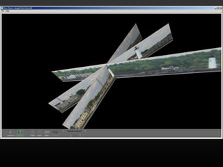
- #28: Once the key images have been identified and grouped by feature, we can begin building the multirama objects. Here is the USCG station and lighthouse at Newcastle, NH.
- #29: The necessity to collect and update all this information may lead to new methods of data entry. We think there is a potential for wiki type interfaces where the community can help contribute their knowledge to upcoming editions of nautical publications. Local mariners have the most experience in many waterways and know first when there are changes to the waterways that impact them.
- #30: This is just the first attempt at implementing a new generation of nautical publications. We hope that the international community looks at this as a place to start discussions on what is needed at all levels of the process and how these tools may be able to keep assisting mariners to effectively utilize the marine environment. We believe that creating an XML distribution method will spur developments of all types of tools built around nautical publications, from value-added cruising guides through to 3D user interfaces. From here, we would like to present some ideas that may influence the production and use of nautical publications in the future.
- #31: This first step is the evaluation of the GeoCoastPilot and the XML infrastructure. We have begun the process, but encourage everyone to participate either through contacting us with your feedback or conducting your own evaluation.
- #33: The Marine Information for Safety and Law Enforcement (MISLE) system provides the USCG a database of incidents that occur under United States jurisdiction. A subset of these incidents are investigated and released to the public. A portion of the public incident records contain information about issues faced by mariners on the waterway (as opposed to things like mechanical failures of vessels). As authors work on future additions of nautical publications, it may be helpful to provide these incidents in an easy to use form such as a Google Earth KML. The authors can then see where text modification might reduce the chances of further incidents.
- #34: This is an example of one incident in the Elizabeth River adjacent to the SNPWG 10 meeting. This particular incident was a line handling issue and has little bearing on nautical publications, but demonstrates how the interface can link the cryptic summary to the complete investigation available on the USCG web site.
- #35: This is one day of vessel traffic in the Hampton Roads, VA area. Having a clear view of where vessels are going and the traffic density might impact decisions about future nautical publication text. Are there areas of the waterway that are safe, but under-utilized? Are there vessels getting too close to hazards of navigation?
- #36: It is easy to add S-57 chart data to the AIS traffic display. This is an older version of EarthNC for the entrance to Delaware Bay.
- #37: Summary plots of vessel density over extended periods of time and broken out by vessel type may be more useful. An animated version of this slide is available on YouTube: http://www.youtube.com/watch?v=TvtMuF945dA
- #38: Also useful will be statistics such as vessel draft. These parameters may shift over time and necessitate changes in the text guiding mariners.
- #39: Using other datasets, it is also possible to look out farther than the regional limits of AIS (20-40km) and see the global ship patterns. This information may help mariners coming from other countries. For example, in this image it is possible to see a ferry transiting frequently across a key area (denoted by the dense group of pink lines running inside the yellow circle).
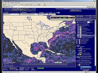
- #40: The Coast Pilot includes tide and current summary tables in the appendices. However, it is becoming possible to present realtime visualizations of operational models of currents to work with the well-established weather displays. Shown here is FlowVis by Colin Ware displayed in NOAAŌĆÖs nowCOAST. These visualizations should be available to the public in the near future. http://nowcoast.noaa.gov
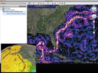
- #41: Outside of the traditional radio, TV, weather fax, and web page delivery mechanisms, it is now possible to present these in a virtual globe such as Google Earth.
- #42: NOAAŌĆÖs Pydro demonstrating receiving realtime AIS waterlevel messages. Pydro uses TCARI to build a finite element model of the water surface. The water surface is differenced against a high resolution bathymetric survey grid to create safe the safe water contour based on the vesselŌĆÖs draught. This demonstration does NOT use ENC depth areas. Down the road when these types of information services are available, what should the Coast Pilot provide as supporting material to help the mariners understand the system? Animation available on YouTube: http://www.youtube.com/watch?v=qo2fLnW7vr8
- #43: Right now, there are two active AIS test beds running the United States. The US meteorology and hydrography message is being tested in Tampa, FL and a timed area notice (TAN) for right whale acoustic detections is being broadcast in the Boston Harbor approaches. The rules that apply to these kinds of data are rapidly changing. How can nautical publications support the communication to the mariner and keep up with the pace of change with the rules? http://listenforwhales.org
- #44: Brennen et al 2007 New technologies such as vessel mounted side-looking LIDAR will be generating vast amounts of data about waterways. How can we use this data to help mariners. The datasets are large and not helpful in their raw form. In the vast point clouds are key details about aids to navigation, piers and other support infrastructure providing as much information as was captured with traditional ŌĆ£as-builtŌĆØ studies. An as-built is a design document created after the fact that is taken from an existing structure to show how the structure was actually built. Over time, this can differ significantly from the original plans and the changes may not be well documented.
- #45: In this presentation, we focused on the concept of a multirama and 2D imagery. 3D models of structures provide different tradeoffs and a high cost to develop. Solutions in the future may include a mix of multirama and 3D model information and may allow the mariner to pick which type of presentation suits their needs. As evidenced by the simulators at maritime training facilities and in virtual globes (e.g. Google Earth), 3D models are becoming more common.
- #46: Please donŌĆÖt hesitate to contact me with question or feedback.