Summary_presentation_TL
0 likes273 views

The document describes a summer project analyzing distance-related variables at the block level in New York City. The project aims to calculate distances from city blocks to various points of interest, such as subway stations, parks, and other amenities, and analyze how these distances impact property values. The methodology uses GIS network analysis to calculate walking distances and Euclidean distances to measure externalities. Distances will be classified into groups for future hedonic modeling. The results can be used as variables to understand how proximity to amenities affects property values.


More Related Content
Viewers also liked (16)
Similar to Summary_presentation_TL (20)


Summary_presentation_TL
- 1. SUMMER PROJECT: DISTANCE-RELATED VARIABLES AT BLOCK LEVEL IN NYC PRESENTER: TIANYUAN LIU INSTRUCTOR: MIN ZHU 08/2015
- 2. CONTENTS âĒ Project Description âĒ Methodology âĒ Takeaway
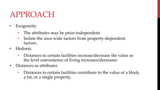
- 4. APPROACH âĒ Exogeneity âĒ The attributes may be price-independent. âĒ Isolate the area-wide factors from property-dependent factors. âĒ Hedonic âĒ Distances to certain facilities increase/decrease the value as the level convenience of living increases/decreases âĒ Distances as attributes âĒ Distances to certain facilities contribute to the value of a block, a lot, or a single property.
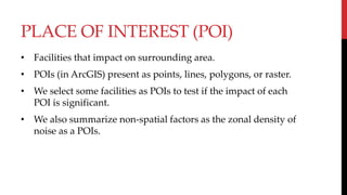
- 5. PLACE OF INTEREST (POI) âĒ Facilities that impact on surrounding area. âĒ POIs (in ArcGIS) present as points, lines, polygons, or raster. âĒ We select some facilities as POIs to test if the impact of each POI is significant. âĒ We also summarize non-spatial factors as the zonal density of noise as a POIs.
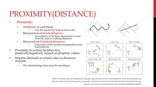
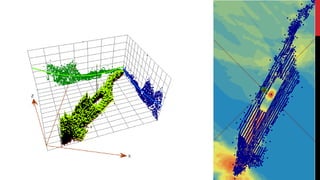
- 6. PROXIMITY(DISTANCE) âĒ Proximity: âĒ Attributes of each block âĒ Test the sensitivity of block-level scale. âĒ Measured as network distances âĒ Accessibility of facilities-dependent of road network, such as walking distances âĒ Measured as Euclidean distances âĒ Externality of the facilities-independent from road network âĒ Proximity to certain facilities may positively/negatively impact on property values. âĒ Impacts diminish at certain rates as distances increase. âĒ The diminishing rates may be non-linear. https://en.wikibooks.org/wiki/Transportation_Geography_and_Network_Science/Circuity#/media/File:TGNS_NetworkDistance.png https://en.wikibooks.org/wiki/Transportation_Geography_and_Network_Science/Circuity#/media/File:TGNS_EuclideanDistance.png http://resources.arcgis.com/en/help/main/10.1/index.html#/Near/00080000001q000000/
- 7. METHODOLOGY
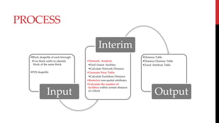
- 8. âĒBlock shapefile of each borough âĒUse block suffix to identify block of the same block âĒPOI shapefile Input âĒNetwork Analysis âĒFind closest facilities âĒCalculate Network Distance âĒGenerate Near Table âĒCalculate Euclidean Distance âĒRasterize non-spatial attributes âĒCalculate the number of facilities within certain distance of a block Interim âĒDistance Table âĒDistance-Dummy Table âĒZonal Attribute Table Output PROCESS
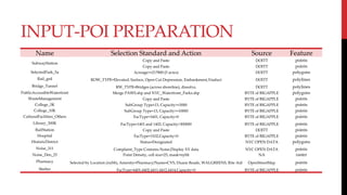
- 9. INPUT-POI PREPARATION Name Selection Standard and Action Source Feature SubwayStation Copy and Paste DOITT points Copy and Paste DOITT points SelectedPark_5a Acreage>=217800 (5 acres) DOITT polygons Rail_grd ROW_TYPE=Elevated, Surface, Open Cut Depression, Embankment,Viaduct DOITT polylines Bridge_Tunnel RW_TYPE=Bridges (across shoreline), dissolve, DOITT polylines PublicAccessibleWaterfront Merge PAWS.shp and NYC_Waterfront_Parks.shp BYTE of BIGAPPLE polygons WasteManagement Copy and Paste BYTE of BIGAPPLE points College_3K SubGroup Type=13, Capacity>=3000 BYTE of BIGAPPLE points College_10K SubGroup Type=13, Capacity>=10000 BYTE of BIGAPPLE points CulturalFacilities_Others FacType=1601, Capacity>0 BYTE of BIGAPPLE points Library_300K FacType=1401 and 1402, Capacity>300000 BYTE of BIGAPPLE points RailStation Copy and Paste DOITT points Hospital FacType=3102,Capacity>0 BYTE of BIGAPPLE points HistoricDistrict Status=Designated NYC OPEN DATA polygons Noise_311 Complaint_Type Contains Noise,Display XY data NYC OPEN DATA points Noise_Den_25 Point Density, cell size=25, mask=nybb NA raster Pharmacy Selected by Location (nybb), Amenity=Pharmacy/Name=CVS, Duane Reade, WALGREENS, Rite Aid OpenStreetMap points Shelter FacType=4401,4402,4411,4412,4414,Capacity>0 BYTE of BIGAPPLE points
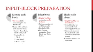
- 10. INPUT-BLOCK PREPARATION Identify each Block âĒNewbase table containing bbl and block suffix âĒSelect index lot from each physical block âĒSort by Boro, Block, Block Suffix, Lot âĒExclude lot of: âĒPid <0 âĒLand size=0 âĒBC=T*, U*, R* Select block âĒDigital Tax Map containing tax lot features âĒTable containing bbl and block suffix âĒJoin by lot BBL âĒLot Feature containing Boro, Block, and Block Suffix. Blocks with blksuf âĒDigital Tax Map tax block feature âĒSpatial Join the lot feature with block feature (get attributes) âĒDissolve to combine the small block with same block and suffix number âĒGenerate centroid for each block
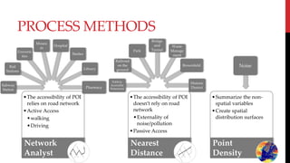
- 11. PROCESS METHODS âĒThe accessibility of POI relies on road network âĒActive Access âĒwalking âĒDriving Network Analyst âĒThe accessibility of POI doesnât rely on road network âĒExternality of noise/pollution âĒPassive Access Nearest Distance âĒSummarize the non- spatial variables âĒCreate spatial distribution surfaces Point Density Subway Station Rail Stations Universi ties Museu m Hospital Shelter Library Pharmacy Publicly Accessible Waterfront Railroad on the ground Park Bridge and Tunnel Waste Manage ment Brownfield Historic District Noise
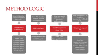
- 12. METHOD LOGIC If the POI should be actively accessed from each blockâĶ Network Analyst (5 nearest POIs) Distance Table: 1st Nearest Distance 2nd Nearest Distance 3rd Nearest Distance 4th Nearest Distance 5th Nearest Distance ArcGIS shapefile If the POI should be passively accessed from each blockâĶ Make Near Table Nearest Distance Table ArcGIS shapefile If the non-spatial attributes can be presented geographicallyâĶ Point Density/Raster/ Zonal Table Zonal Table: Non-spatial attributes If the number of POIs were to be summarized at block levelâĶ Multiple Buffers/Spatial Join Count Table: Numbers of POIs of each block at distance_1 Numbers of POIs of each block at distance_2 ArcGIS shapefile
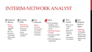
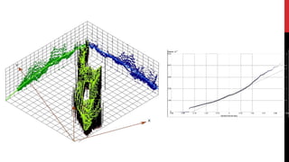
- 13. INTERIM-NETWORK ANALYST Incidents -Blocks âĒBlock centroid shapefile (OID) âĒBy boro âĒGenerate IncidentID âĒReasonable Check Facilities - POIs âĒPOI (Point features only âĒGenerate FacilityID âĒFrom incidents to facilities Use Network âĒRoad Network âĒ Generated from CSCL Centerline (topology) Solve âĒUse incidents, facilities, and network feature layers âĒFind the Closest Facility âĒNumber of POIs to find=5 âĒUse trip length as impedance Save results âĒSave route feature class âĒSave the 5 distance values to table âĒTranspose by incident Join Distance back to Block âĒDistance table with IncidentID âĒBlocks with IncidentsID âĒBlocks with OID
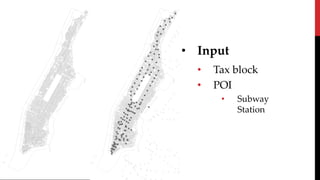
- 14. âĒ Input âĒ Tax block âĒ POI âĒ Subway Station
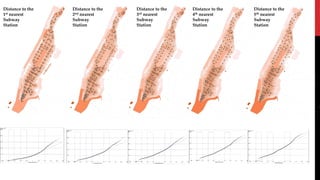
- 15. Distance to the 1st nearest Subway Station Distance to the 2nd nearest Subway Station Distance to the 3rd nearest Subway Station Distance to the 4th nearest Subway Station Distance to the 5th nearest Subway Station
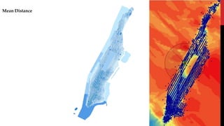
- 16. Mean Distance
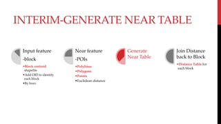
- 18. INTERIM-GENERATE NEAR TABLE Input feature -block âĒBlock centroid shapefile âĒAdd OID to identify each block âĒBy boro Near feature -POIs âĒPolylines âĒPolygons âĒPoints âĒEuclidean distance Generate Near Table Join Distance back to Block âĒDistance Table for each block
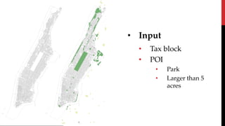
- 19. âĒ Input âĒ Tax block âĒ POI âĒ Park âĒ Larger than 5 acres
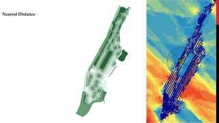
- 20. Nearest Distance
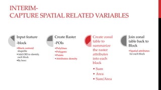
- 22. INTERIM- CAPTURE SPATIAL RELATED VARIABLES Input feature -block âĒBlock centroid shapefile âĒAdd OID to identify each block âĒBy boro Create Raster -POIs âĒPolylines âĒPolygons âĒPoints âĒAttributes: density Create zonal table to summarize the raster attributes into each block âĒ Sum âĒ Area âĒ Sum/Area Join zonal table back to Block âĒSpatial attributes for each block
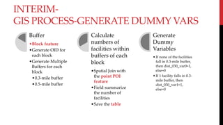
- 25. INTERIM- GIS PROCESS-GENERATE DUMMY VARS Buffer âĒBlock feature âĒGenerate OID for each block âĒGenerate Multiple Buffers for each block âĒ0.3-mile buffer âĒ0.5-mile buffer Calculate numbers of facilities within buffers of each block âĒSpatial Join with the point POI feature âĒField summarize the number of facilities âĒSave the table Generate Dummy Variables âĒIf none of the facilities fall in 0.3-mile buffer, then dist_030_var0=1, else=0 âĒIf 1 facility falls in 0.3- mile buffer, then dist_030_var1=1, else=0
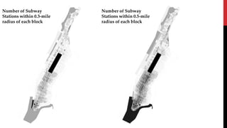
- 26. âĒ Input âĒ Tax block âĒ POI âĒ Subway Station
- 27. Number of Subway Stations within 0.3-mile radius of each block Number of Subway Stations within 0.5-mile radius of each block
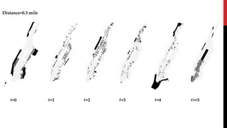
- 28. Distance=0.3 mile #=0 #=1 #=2 #=3 #=4 #>=5
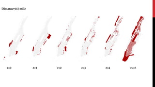
- 29. Distance=0.5 mile #=0 #=1 #=2 #=3 #=4 #>=5
- 31. TAKEAWAY
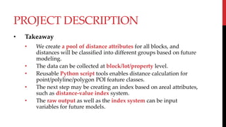
- 32. PROJECT DESCRIPTION âĒ Takeaway âĒ We create a pool of distance attributes for all blocks, and distances will be classified into different groups based on future modeling. âĒ The data can be collected at block/lot/property level. âĒ Reusable Python script tools enables distance calculation for point/polyline/polygon POI feature classes. âĒ The next step may be creating an index based on areal attributes, such as distance-value index system. âĒ The raw output as well as the index system can be input variables for future models.
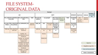
- 33. FILE SYSTEM- ORIGINAL DATA RawInput DCP DOITT OPENDATA OpenStreet Collected workflow_d ocumentati on NYC_PubliclyAccessibleWater Front_2014 NYC_SelectedFacilities_ 2015 TANK Borough_Bo undaries cscl_pub.gdb NYC_Planim etrics_2010 Noise_311_ 07012014_0 7012015 TANK remedsitebo rders new- york_new- york.osm- point.shp Potential Materials nyc_paws_2 014shp nyc_waterfrontp arks_2014shp nyc_facilities2015_shp Potential Materials nybb_15b CSCL SubwayStati on.shp NYC_DOITT_ Planimetric_ Seamless_2 010.gdb Potential Materials Remediatio n_site_bord ers PAWS.shp NYC_Waterfront _Parks.shp Facilities - 01 - Schools.lyr nybb.shp Centerline.s hp RailStation.s hp NYCPlanime tric Remediation _site_border s.shp Facilities - 02 - Recreational & Cultural Facilities.lyr Rail.shp PARK.shp Facilities - 04 - Nursing Homes, Hospitals, Hospices and Ambulatory Services.lyr Subway.shp Facilities - 10 - Food Programs & Residential Facilities for Adults and Families.lyr Facilities - 12 - Waste Management Facilities.lyr Table File Shapefile or Layer File Tools and Documentation Folder or Geodatabase
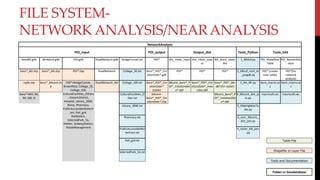
- 34. FILE SYSTEM- NETWORK ANALYSIS/NEARANALYSIS NetworkAnalysis POI_input POI_output Output_dist Tools_Python Tools_SAS boroBD.gdb dtmblock.gdb POI.gdb RoadNetwork.gdb BridgeTunnel.txt POI* dist_mean_input dist_mean_outp ut NA_block_mean dist 1_BlkSuf.py POI_MakeNear Table POI_NetworkAn alyst boro*_BD.shp boro*_blk.shp POI*.shp RoadNetwork College_3K.txt boro*_POI*_Cre ationDate*.gdb POI* POI* POI* 2_blksuf_cent_to _poigdb.py POI* (create near table) POI*(for network analysis) nybb.shp boro*_blkcent.sh p POI*=BridgeTunnel, Brownfield, College_3K, College_10K, CulturalFacilities_Others , HistoricDistrict, Hospital, Library_300K, Noise, Pharmacy, PublicAccessibleWaterfr ont, Rail_grd, RailStation, SelectedPark_5a, Shelter, SubwayStation, WasteManagement RoadNetwork_ND College_10K.txt boro*_POI*_Cre ationDate* (table) blkcent_boro*_P OI*_CreationDat e*.dbf boro*_POI*_Cre ationDate*_mea ndist.dbf boro*_POI*_blk. dbf (for raster) 3_NA_NF.py boro_macro.sa s boro_macro.sa s boro*=MH, BX, BK, QN, SI CulturalFacilities_O ther.txt blkcent- boro*_POI*_Cre ationDate*.shp blkcent_boro*_P OI*_CreationDat e*.dbf 4_Blkcent_dist_jo in.py macrocall.sas macrocall.sas Library_300K.txt 5_MakingNearTa ble.py Pharmacy.txt 6_near_Blkcent_ dist_join.py PublicAccessibleWa terfront.txt 9_raster_blk_join .py Rail_grd.txt SelectedPark_5A.txt Table File Shapefile or Layer File Tools and Documentation Folder or Geodatabase
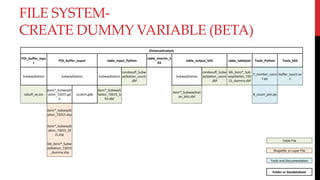
- 35. FILE SYSTEM- CREATE DUMMY VARIABLE (BETA) DistanceAnalysis POI_buffer_inpu t POI_buffer_ouput table_input_Python table_interim_S AS table_output_SAS table_tablejoin Tools_Python Tools_SAS SubwayStation SubwayStation SubwayStation condosuff_Subw ayStation_count .dbf SubwayStation condosuff_Subw ayStation_count .dbf blk_boro*_Sub wayStation_720 15_dummy.dbf 7_number_coun t.py buffer_count.sa s cdsuff_xy.csv boro*_SubwaySt ation_72015.gd b scratch.gdb boro*_SubwayS tation_72015_b fct.dbf boro*_SubwayStati on_bfct.dbf 8_count_join.py boro*_SubwaySt ation_72015.shp boro*_SubwaySt ation_72015_bf ct.shp blk_boro*_Subw ayStation_72015 _dummy.shp Table File Shapefile or Layer File Tools and Documentation Folder or Geodatabase
- 36. *FUTURE ACTIONS- ADD POI âĒ Download original shapefiles in RawInput Folder âĒ Sort by the source of the files (DCP, DOITT, OPENDATA, OpenStreetMap, or SelfCollectionâĶ) âĒ Put POI shapefiles in POI_inputPOI.gdb âĒ Select the Python Tools and SAS Tools to process âĒ Need to change POIs manually in each script
- 37. *FUTURE ACTIONS- TOOLS AND RESULT TABLESâĶ âĒ Network Analysis- âĒ Input âĒ POI_inputPOI.gdb âĒ POI_inputdtmblock.gdbblk(cent) âĒ Point Features only âĒ Tool_Python3_NA_NF.py âĒ dist_mean_inputPOI*dbf âĒ Tool_SASPOI_NetworkAnalystboro_macro âĒ dist_mean_outputPOI*dbf âĒ Tool_Python4_blkcent_dist_join âĒ NA_block_meandistPOI*dbf âĒ Generate Near Table- âĒ Input âĒ POI_inputPOI.gdb âĒ POI_inputdtmblock.gdbblk(cent) âĒ Point/Polyline/Polygon features âĒ Tool_Python5_make_near_table.py âĒ dist_mean_inputPOI*dbf âĒ Tool_SASPOI_MakeNearTable boro_macro âĒ dist_mean_outputPOI*dbf âĒ Tool_Python 6_near_Blkcent_dist_join.py âĒ NA_block_meandistPOI*dbf
- 38. *FUTURE ACTIONS- SUMMARIZE THE RESULT âĒ Summarize the result in the master table of each boro âĒ Output_distDescriptiveboro*.xlsx âĒ Sort the result based on the method of distance calculation âĒ Near âĒ Sorted by ORIG_FID âĒ Network Analyst âĒ Sorted by ORIG_FID âĒ Mark the missing value with IncidentID âĒ Raster (Beta) âĒ Sorted by OID_12 âĒ Mark the missing value with IncidentID